
Ports & Harbours of the North Sea
YearMaps maps 144 harbours on the North Sea, in 7 countries and territories. The largest by the World Port Index's harbour size are Dundee, Bremen, London, Antwerpen, Bremerhaven and Amsterdam. 13 are written up in full below, and every harbour is listed with its depths, tidal range and the largest ships it takes.
The North Sea is a shallow shelf sea of the Atlantic, averaging about 95 m deep, between Great Britain, Norway, Denmark, Germany and the Low Countries. Rotterdam, Antwerp, Hamburg and London grew on the estuaries of the Rhine and Meuse, the Scheldt, the Elbe and the Thames that open onto it, and it was the home water of the Vikings, the Hanseatic League and the Dutch merchant fleets. Its oil and gas fields have been worked since the 1960s.
- Harbours
- 144
- Countries
- 7
- Large Harbours
- 7
- Written Up
- 13
Map of the Ports of the North Sea
Blue dots are the harbours of the World Port Index; tap or click one to open its entry. Use the layer panel to add trade routes, rivers and historical borders.
Harbours of the North Sea in Detail
The 13 harbours of the North Sea with an encyclopedia article, each with its figures from the World Port Index.

Grimsby
Medium harbour · United Kingdom
The Port of Grimsby is located on the south bank of the Humber Estuary at Grimsby in North East Lincolnshire. Sea trade out of Grimsby dates to at least the medieval period. The Grimsby Haven Company began dock development in the late 1700s, and the port was further developed from the 1840s onwards by the Manchester, Sheffield and Lincolnshire Railway (MSLR) and its successors. The port has had three main dock systems:
The earliest dock, or Old Dock was developed in the 1790s, downriver from the medieval Haven, on the outfall of the same water course; in around 1880 it was expanded westwards, and renamed Alexandra Dock, being connected to the Royal Dock system by a short canal, named the Union Dock. From the 1880s the dock's focus was coal, later timber. From the 1970s onwards the dock has been used for large-scale car importation.
The Royal Dock was developed from the 1840s onwards, contemporary with the arrival of the railway – it was built on a large area of land reclaimed from the Humber Estuary north-east of the original town and harbour. The dock's trade has included a wide variety of goods including coal, timber and general merchandise.
Adapted from Wikipedia: Port of Grimsby (CC BY-SA 4.0).
- Harbour size
- Medium
- Channel depth
- 45.7 m
- Anchorage depth
- 53 m
- Cargo pier depth
- 49.4 m
- Tidal range
- 6 m
- Largest vessel
- medium vessels
- Country
- United Kingdom
- Province
- England
- Coordinates
- 53.5800°, -0.0700°
More about Grimsby
History
Grimsby's development as a landing place and town has an underlying basis in the area's geography – the combination of relatively high ground (compared to surrounding land) of over 16 feet (5 m), near to the Humber, and close to a water outfall (The Haven).
Grimsby has been documented as a landing place dating to at least the Viking Age. According to 19th century writers Grimsby was referenced in medieval histories as the landing place of marauding Danish armies. The haven is also reputed to be the landing place of the semi-legendary figures Grim and Havelok in the town's founding myth, Havelok the Dane (written c. 13th century).
Sections adapted from Wikipedia: Port of Grimsby (CC BY-SA 4.0).
Immingham
Medium harbour · United Kingdom
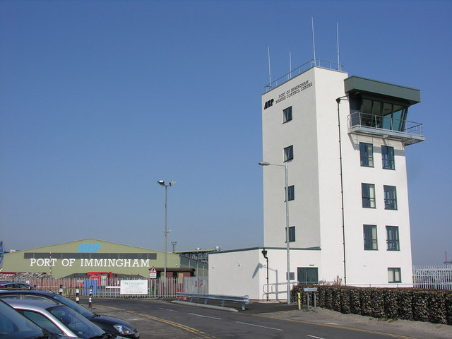
The Port of Immingham, also known as Immingham Dock, is a major port on the east coast of England, on the south bank of the Humber in the town of Immingham, Lincolnshire. In 2019, the Port of Grimsby & Immingham was the largest port in the United Kingdom by tonnage, with 54.1 million tonnes of cargo passing through that year.
The port was established by the Humber Commercial Railway and Dock Company in association with the Great Central Railway; the dock company incorporated and the works permitted by the Humber Commercial Railway and Dock Act 1901 (1 Edw. 7. c. ccii). Construction of the dock started in 1906 and was completed by 1912. The original main purpose of the dock was export of coal.
Adapted from Wikipedia: Port of Immingham (CC BY-SA 4.0).
- Harbour size
- Medium
- Channel depth
- 42.1 m
- Anchorage depth
- 49.4 m
- Cargo pier depth
- 31.1 m
- Oil terminal depth
- 38.4 m
- Tidal range
- 5 m
- Largest vessel
- large vessels
- Country
- United Kingdom
- Province
- Lincolnshire
- Coordinates
- 53.6300°, -0.2000°
More about Immingham
History
From the mid 19th century onwards the Manchester, Sheffield and Lincolnshire Railway developed the Port of Grimsby into a modern outlet for its rail system onto the east coast of England.
In 1874 a report was commissioned from Charles Liddell on alternatives to expansion at Grimsby – it recommended a new dock west of Grimsby at South Killingholme, preferable due to low land costs and proximity to the Humber Estuary's navigable channel. Liddell's scheme was not proceeded with at that time.
Plans were submitted to Parliament in 1902 for a dock near Immingham, but the bill was withdrawn due to conditions requiring the GCR to dredge the Humber shipping channels to undo any change thought to have been caused by the dock works.
Sections adapted from Wikipedia: Port of Immingham (CC BY-SA 4.0).

Peterhead
Medium harbour · United Kingdom
Peterhead Harbour is a harbour in Peterhead, Aberdeenshire, Scotland. Situated immediately northeast of Peterhead Bay, it is composed of three harbours: Port Henry, North Harbour and South Harbour. The harbour is a Category B listed structure.
Queenie Bridge connects Bridge Street and Greenhill Road between North Harbour and South Harbour.
The harbour is owned and maintained by Peterhead Port Authority, which was formed in 2006 via a merger of Peterhead Bay Authority and Peterhead Harbour Trustees.
Adapted from Wikipedia: Peterhead Harbour (CC BY-SA 4.0).
- Harbour size
- Medium
- Channel depth
- 38.4 m
- Anchorage depth
- 31.1 m
- Cargo pier depth
- 38.4 m
- Oil terminal depth
- 38.4 m
- Tidal range
- 3 m
- Largest vessel
- large vessels
- Country
- United Kingdom
- Province
- Scotland
- Coordinates
- 57.5000°, -1.7800°
More about Peterhead
History
The harbour was formed by the filling in of the water around the former islands of Keith Inch and Greenhill. When Peterhead was founded, in 1593, it was known as the "Harbour and Barony of Keith Insche commonly called Peterhead".
The harbour was proving so valuable that in 1738, the Leith shipmasters attested that "the harbour of Peterhead is in our opinion the best situate of any place in Scotland for all ships trading on the north seas".
In 1815, before the increase in herring popularity, there were 72 vessels registered to Peterhead operating from the port; by 1850 there were over 400.
North Harbour and the dry dock were built by John Rennie and Thomas Telford between 1818 and 1822. They were improved fifteen years later.
Sections adapted from Wikipedia: Peterhead Harbour (CC BY-SA 4.0).
Methil
Small harbour · United Kingdom
The Methil Docks are situated in Methil, Fife, Scotland, on the northern shores of the Firth of Forth. Historically, the docks served as a port for the transport of coal cargoes. However, since the decline of the mining industry of Fife, the port now specialises as a wood pulp and timber distribution centre.
Adapted from Wikipedia: Methil Docks (CC BY-SA 4.0).
- Harbour size
- Small
- Channel depth
- 56.7 m
- Anchorage depth
- 34.7 m
- Cargo pier depth
- 49.4 m
- Tidal range
- 3 m
- Largest vessel
- medium vessels
- Country
- United Kingdom
- Coordinates
- 56.1800°, -3.0000°
More about Methil
History
No. 1 dock was built by Cunningham, Blythe and Westland and completed May 1887. No.2 dock was completed in January 1900 and No. 3 dock was built by Sir Robert McAlpine and completed in 1913. No.3 dock closed in 1977. Plans in the early 2000s to convert the area into a network of restaurants and social space fell through due to a lack of funds. The project, provisionally named Methil Ramblas, would have included al fresco dining, cafes, and open-air fitness sessions.
Sections adapted from Wikipedia: Methil Docks (CC BY-SA 4.0).

Goole
Small harbour · United Kingdom
The Port of Goole (also known as Goole Docks and The Port in Green Fields), is a maritime port at the mouth of the Aire and Calder Navigation where it feeds into the River Ouse, in the East Riding of Yorkshire, England. The port opened in 1826, when the Aire and Calder Navigation was completed, connecting to the River Ouse at what is now the town of Goole. The port is one of the Humber Ports, associated with the waterway of the Humber Estuary and its tributaries, and is known to be Britain's largest inland port, being some 50 miles (80 km) from the open sea. It has good road and rail transport links, and deals with about £800 million worth of trade each year.
Originally the port was in the West Riding of Yorkshire, but was transferred to Humberside in 1974, then it was moved into the East Riding of Yorkshire in 1996.
Adapted from Wikipedia: Port of Goole (CC BY-SA 4.0).
- Harbour size
- Small
- Channel depth
- 53 m
- Cargo pier depth
- 49.4 m
- Tidal range
- 5 m
- Largest vessel
- medium vessels
- Country
- United Kingdom
- Coordinates
- 53.7000°, -0.8300°
More about Goole
History
Whilst the location of Goole as a settlement has been around since Anglo-Saxon times, the land surrounding the area of Goole was marshy, and only drained when King Charles I granted Cornelius Vermuyden the right to drain the land and divert the River Don into the Ouse, rather than the Trent. The River Don had hitherto drained eastwards directly into the Trent at Adlingfleet. Prior to the diversion of the River Don (which became known as the Dutch River), and the opening of the Aire and Calder Navigation, Goole itself was a tiny hamlet, on the south bank of the River Ouse. In 1821, five years before the port was opened, the population of Goole was listed as 450; by 1831, it had increased threefold to 1,671. By 1901, the town had grown to 4,549 residents.
Geography
The port is connected at the west end to the Aire and Calder Navigation, with the Dutch River (the new course of the River Don) immediately to the south of the canal, and they run alongside each other to the west for 6 miles (9.7 km). Initially, the port only had two locks; Barge Lock (3 acres (1.2 ha)) controlled entry into the River Ouse, and Ship Lock (2.75 acres (1.11 ha)) was a little further north, connected to the canal end of Barge Dock. Despite the small size of both locks, they could hold about 60 ships and 200 barges, and the nascent port was known to be quite efficient at the transshipment of goods. A timber pond was built on the western approach to the dock on the Aire and Calder Navigation, but this was later developed into South Dock.
Sections adapted from Wikipedia: Port of Goole (CC BY-SA 4.0).

Lowestoft
Small harbour · United Kingdom
The Port of Lowestoft is a harbour and commercial port in Lowestoft in the English county of Suffolk owned by Associated British Ports. It is the most easterly harbour in the United Kingdom and has direct sea access to the North Sea. The harbour is made up of two sections divided by a bascule bridge. The inner harbour is formed by Lake Lothing whilst the outer harbour is constructed from breakwaters. Lowestoft handles around 30,000 tonnes of cargo per year.
Traditionally the harbour was the site for an extensive fishing industry as well as engineering and shipbuilding companies such as Brooke Marine, Richards and Boulton and Paul. The offshore oil and gas industry has also operated from the harbour with Shell maintaining their Southern Operations base in the harbour from the mid-1960s until 2003. Today, the Port is a hub for renewable offshore energy generation, with companies including SSE and Scottish Power Renewables having their maintenance & operations bases at Lowestoft.
Adapted from Wikipedia: Port of Lowestoft (CC BY-SA 4.0).
- Harbour size
- Small
- Channel depth
- 53 m
- Anchorage depth
- 42.1 m
- Cargo pier depth
- 49.4 m
- Oil terminal depth
- 49.4 m
- Tidal range
- 2 m
- Largest vessel
- medium vessels
- Country
- United Kingdom
- Province
- England
- Coordinates
- 52.4800°, 1.7500°
More about Lowestoft
History
The harbour was originally built by the Lowestoft and Norwich Navigation Company and developed by the Norfolk Railway following the construction of the Norwich to Lowestoft railway. The original Inner Harbour was constructed in 1831 when Lake Lothing was joined to the sea, as shown on a chart based on a survey by William Hewett of HMS Fairy dated 1834, while the Outer Harbour was constructed in 1937. The railway line ran along the north side of the docks and a series of docks railway sidings were used mainly for fishing and freight wagons. These lines have mainly been removed from service but in places sections of the track can be seen.
Sections adapted from Wikipedia: Port of Lowestoft (CC BY-SA 4.0).

Whitby
Small harbour · United Kingdom
The Port of Whitby is an ancient and historic seaport on the North Yorkshire coast of England. The port lies at the mouth of the River Esk, where it enters the North Sea. A port has been in existence at Whitby since at least the 7th century, when it was used to bring in supplies for Whitby Abbey. The port is famous for being the port of origin for the sailings of Captain Cook, and some of the ships that he sailed on were also built in the harbour.
Commercial cargo ceased in the late 20th century; however, the port is still important for the landing of fish.
Adapted from Wikipedia: Port of Whitby (CC BY-SA 4.0).
- Harbour size
- Small
- Channel depth
- 49.4 m
- Anchorage depth
- 31.1 m
- Cargo pier depth
- 56.7 m
- Tidal range
- 4 m
- Largest vessel
- medium vessels
- Country
- United Kingdom
- Coordinates
- 54.4800°, -0.6200°
More about Whitby
History
No records exist of actual dates when the port started, but fish were being landed at Whitby during the time that the first abbey had been built in 657. It is thought that the port was in what is now the upper harbour (south of the swing bridge, as coastal erosion had not yet subjected the lower harbour cliff walls to collapse, making that side of the estuary too steep to house piers). William de Percy granted the port to the abbey at Whitby, a grant which was confirmed by William II sometime before 1096. In 1122, a dispute was recorded in the collection of tithes from fishermen due to the abbot, which also noted that coal was imported into Whitby.
Sections adapted from Wikipedia: Port of Whitby (CC BY-SA 4.0).
Ramsgate
Small harbour · United Kingdom
The Port of Ramsgate (also known as Port Ramsgate, Ramsgate Harbour, and Royal Harbour, Ramsgate) is a harbour situated in Ramsgate, south-east England, serving cross-Channel freight traffic and smaller working and pleasure craft. It is owned and operated by Thanet District Council.
Adapted from Wikipedia: Port of Ramsgate (CC BY-SA 4.0).
- Harbour size
- Small
- Channel depth
- 45.7 m
- Anchorage depth
- 56.7 m
- Cargo pier depth
- 45.7 m
- Tidal range
- 5 m
- Largest vessel
- medium vessels
- Country
- United Kingdom
- Province
- Kent
- Coordinates
- 51.3300°, 1.4200°
More about Ramsgate
History
The construction of Ramsgate Harbour began in 1749, and was completed in about 1850. The two most influential architects of the harbour were father and son John Shaw and John Shaw Jr, who designed the clock house, the obelisk, the lighthouse and the Jacob's Ladder steps.
The harbour has the unique distinction of being the only harbour in the United Kingdom awarded the right to call itself a Royal Harbour. This was bestowed by King George IV after he was taken by the hospitality shown by the people of Ramsgate when he used the harbour to depart and return with the Royal Yacht Squadron in 1821. In 2024 the harbour was designated a Heritage Harbour.
Sections adapted from Wikipedia: Port of Ramsgate (CC BY-SA 4.0).

Harwich
Small harbour · United Kingdom
Harwich International Port is a North Sea seaport in Essex, England, and one of the Haven ports. It lies on the south bank of the River Stour 1 mile (1.5 kilometres) upstream from the town of Harwich, opposite the Port of Felixstowe. The port was formerly known as Parkeston Quay.
Adapted from Wikipedia: Harwich International Port (CC BY-SA 4.0).
- Harbour size
- Small
- Channel depth
- 31.1 m
- Anchorage depth
- 34.7 m
- Cargo pier depth
- 38.4 m
- Oil terminal depth
- 42.1 m
- Tidal range
- 3 m
- Largest vessel
- large vessels
- Country
- United Kingdom
- Province
- Essex
- Coordinates
- 51.9500°, 1.2800°
More about Harwich
History
The Great Eastern Railway, which was formed from the merging of the Eastern Counties Railway and the Eastern Union Railway in 1862, operated passenger steamers across the North Sea from Harwich to continental Europe. By 1872, shipping trade had increased so that more capacity was required and the Great Eastern Railway obtained permission to reclaim land at Ray Farm, a mile to the west of Harwich, and build a new quay. This new quay was opened in 1883 by Charles H. Parkes, the chairman of the Great Eastern Railway company, the port being named after him as Parkeston Quay. The port had its own railway station, and a hotel was built between the northern platform and the quay; the hotel building is now used as offices.
Current operations
The main user of the port is the regular ferry services of Stena Line who run twice daily passenger and freight services to the Hook of Holland; as well as freight only services to Rotterdam Europort. The main vessels serving the port are the RoPax ferries the Stena Hollandica and the Stena Britannica, and the RoRo ferries.
Previously, DFDS Seaways operated services to Esbjerg, Denmark (ceased 29 September 2014), Cuxhaven (and before that to Hamburg), Germany, and Gothenburg, Sweden; the latter two services were discontinued by 2005.
Cruise ships once called regularly at the port during the summer months, although in recent times these calls have become more and more infrequent. The year 2016 saw 12 visits – the lowest since the service started.
Facilities
There are four ro-ro berths with linkspans. The specialised pier for the High Speed Ferry Discovery is disused now that the high-speed ferry service has been discontinued and its linkspan has been removed. There are extensive railway sidings adjacent to and within the port with 40 acres (16 hectares) of standing for cars including electric vehicle charging points. In total, there are over 105 acres (42 hectares) of operational land with parking for over 1,000 trailers.
Sections adapted from Wikipedia: Harwich International Port (CC BY-SA 4.0).

Tilbury
Small harbour · United Kingdom
The Port of Tilbury is a port located on the River Thames at Tilbury in Essex, England. It serves as the principal port for London, as well as being the main United Kingdom port for handling the importation of paper. There are extensive facilities for shipping containers, grain, and other bulk cargoes. There are also facilities for the importation of cars. It forms part of the wider Port of London.
Adapted from Wikipedia: Port of Tilbury (CC BY-SA 4.0).
- Harbour size
- Small
- Anchorage depth
- 45.7 m
- Cargo pier depth
- 38.4 m
- Tidal range
- 3 m
- Largest vessel
- medium vessels
- Country
- United Kingdom
- Province
- Essex
- Coordinates
- 51.4700°, 0.3300°
More about Tilbury
History
The original docks of London, all built close to the City, were opened in stages by what were to become the East and West India Dock Company (E&WIDC) and the London and Saint Katharine Docks Company (L&StKDC) at the beginning of the 19th century. With the coming of the railways and increasing ship size, proximity to the centre of London became less important than access to deep water, unrestricted sites, and reduction in time spent traveling up the winding Thames.
The E&WIDC had long been in competition with its rival, the L&StKDC. The opening of the Royal Albert Dock by the L&StKDC, with its deepwater quayage, in 1880 had given access to the Thames at Gallions Reach, 11 miles (18 km) by river below London Bridge and downstream of the then principal London docks.
Geography
The Port of Tilbury lies on the north shore of the River Thames, 25 miles (40 km) downstream of London Bridge, at a point where the river makes a loop southwards, and where its width narrows to 800 yards (730 m). The loop is part of the Thames lower reaches: within the meander was a huge area of marshland. Gravesend on the opposite shore had long been a port of entry for shipping, all of which had used the river itself for loading and unloading of cargo and passengers. There was also a naval dockyard at Northfleet at the mouth of the Ebbsfleet River. The new deep-water docks were an extension of all that maritime activity.
Sections adapted from Wikipedia: Port of Tilbury (CC BY-SA 4.0).

Wisbech
Small harbour · United Kingdom
Port of Wisbech is an inland port on the River Nene in Wisbech, Isle of Ely, Cambridgeshire, United Kingdom. It is mainly used for cargo and industrial purposes, with the southern part of the port housing a number of berths for yachts. Fenland District Council is the harbour authority for most of the River Nene; as well as operating the port and harbour, it provides a Port Health service to commercial ships, leisure craft and fishing vessels. The port runs a fortnightly service from Riga, Latvia importing from the Baltic.
Adapted from Wikipedia: Port of Wisbech (CC BY-SA 4.0).
- Harbour size
- Small
- Anchorage depth
- 49.4 m
- Cargo pier depth
- 53 m
- Tidal range
- 4 m
- Largest vessel
- medium vessels
- Country
- United Kingdom
- Coordinates
- 52.6700°, 0.1500°
More about Wisbech
History
Wisbech was an Anglo-Saxon port on The Wash and continued to serve as a port in medieval times. After the estuary of the River Ouse became silted up, it was diverted into the sea at King's Lynn. This led to the construction of the present course of the River Nene from Peterborough to the Wash. The drained marshes provided rich productive farmland, bringing prosperity to the port of Wisbech from the regular shipments of corn and oil seed rape to the coast and continent, and imports which included coal from the North, slate from Wales and timber from the Baltic. Woad (Isatis tinctoria) was shipped out from the port.
Sections adapted from Wikipedia: Port of Wisbech (CC BY-SA 4.0).

Dunbar
Very Small harbour · United Kingdom
Dunbar Harbour is a seaport forming the north-east part of the town of Dunbar, East Lothian, Scotland. It is situated on a point projecting from the North Sea coast of East Lothian into the mouth of the Firth of Forth.
The built harbour, on the site of an earlier natural anchorage, comprises three main sections: the Old Harbour, in the east of the port, protected by a sea-wall to its east and north and dating from the late 16th-Century; the New or Victoria Harbour in the west dating from 1842; and Broad Haven, formerly the approach from the Forth to the Old Harbour, but latterly, its entrance having been blocked, providing additional sheltered water between the Old and New Harbours.
The harbour is a trust port, responsibility for which lies since 2004 with the Dunbar Harbour Trust. In prior times the port was controlled by the local authority and, earlier, by the magistrates and council of the burgh. It is the home port for a commercial fishing fleet, offering moorings and fuel and water facilities for pleasure yachts. It is the base for local sailing, rowing and diving clubs, as well as for the Royal National Lifeboat Institution station.
Adapted from Wikipedia: Dunbar Harbour (CC BY-SA 4.0).
- Harbour size
- Very Small
- Channel depth
- 53 m
- Anchorage depth
- 31.1 m
- Cargo pier depth
- 49.4 m
- Oil terminal depth
- 42.1 m
- Tidal range
- 3 m
- Largest vessel
- medium vessels
- Country
- United Kingdom
- Coordinates
- 56.0000°, -2.5200°
More about Dunbar
History
For centuries Dunbar has been a port, although the harbour was originally situated at Belhaven, which lies to the west of Dunbar. The first known reference to this port is in an 1153 grant to the monks of May, at the formation of the Isle of May Priory, of a homestead "near my port of Bele" given by Gospatric III, Earl of Lothian. It is referenced again in a 1369/70 grant by David II of Scotland to George Dunbar, 10th Earl of March of "a free Dunbar... and a free port at the Bellehaven... with free entry and exit of ships". Belhaven continued in use up to the 19th-century; its site is thought to be on land now reclaimed by the C19 construction of a sea-wall running east–west between Belhaven village and Biel Water.
Sections adapted from Wikipedia: Dunbar Harbour (CC BY-SA 4.0).

Felixstowe
Very Small harbour · United Kingdom
The Port of Felixstowe, in Felixstowe, Suffolk, is the United Kingdom's largest container port, dealing with 48% of Britain's containerised trade. In 2017, it was ranked as 43rd busiest container port in the world and 8th in Europe, with a handled traffic of 3.85 million twenty-foot equivalent units (TEU). In 2019 it was ranked the UK's 7th busiest port.
The port is operated by the Felixstowe Dock and Railway Company, which was set up under an act of Parliament, the Felixstowe Railway and Pier Act 1875 (38 & 39 Vict. c. cxlv), and so is one of the few limited companies in the UK that do not have the word "Limited" in their name. Much of the land on which it sits is owned by Trinity College, Cambridge, which in the 1930s bought some land near Felixstowe which included a dock that was too small to be included in the National Dock Labour Scheme. In 1967, it set up Britain's first container terminal for £3.5m in a deal with Sea-Land Service. Because container shipping is much more economically efficient in bulk, this early start led to it becoming the UK's largest container port, despite its previous insignificance to the shipping market.
Adapted from Wikipedia: Port of Felixstowe (CC BY-SA 4.0).
- Harbour size
- Very Small
- Channel depth
- 27.4 m
- Anchorage depth
- 34.7 m
- Cargo pier depth
- 45.7 m
- Oil terminal depth
- 42.1 m
- Tidal range
- 2 m
- Largest vessel
- large vessels
- Country
- United Kingdom
- Province
- Suffolk
- Coordinates
- 51.9500°, 1.3200°
More about Felixstowe
Description
The port has two main container terminals, Trinity and Landguard, as well as a roll-on/roll-off terminal.
There is a continuous quay of over 2.3 kilometres (1.4 miles), equipped with 29 ship-to shore gantry cranes. The main navigation channel is dredged to 14.5 m (48 ft) below chart datum, with a maximum depth of 15 m (49 ft) alongside the quay. This allows Felixstowe to accommodate the world's latest generation of deep-draughted post-Panamax vessels and the much larger Maersk Triple E class, launched in 2013 and capable of carrying 18,000 TEUs.
The A14 connects the port to the English Midlands and the M6, the north via the M1 and M6 and A1 and via the A12 to London. The port (as simply "Felixstowe") is signed from as far away as M6 junction 1 for Rugby.
Sections adapted from Wikipedia: Port of Felixstowe (CC BY-SA 4.0).
All Harbours of the North Sea
144 harbours, the largest first by the index's harbour size. Channel depth and tidal range set the physical limit on which ships can call. 25 of them are recorded in the source with the city they serve.
| Harbour | Country | Size | Channel | Anchorage | Tide | Largest vessel | Map |
|---|---|---|---|---|---|---|---|
| Dundee | United Kingdom | Major | 45.7 m | — | 5 m | large vessels | |
| Bremen | Germany | Major | 42.1 m | — | 4 m | medium vessels | |
| London | United Kingdom | Major | 42.1 m | — | 6 m | large vessels | |
| Antwerpen | Belgium | Major | 34.7 m | — | 4 m | medium vessels | |
| Bremerhaven | Germany | Major | 34.7 m | — | 4 m | medium vessels | |
| Amsterdam | Netherlands | Major | 31.1 m | — | 2 m | medium vessels | |
| Teesport | United Kingdom | Major | 27.4 m | 31.1 m | 3 m | medium vessels | |
| Aberdeen | United Kingdom | Medium | 49.4 m | — | 4 m | large vessels | |
| Grimsby | United Kingdom | Medium | 45.7 m | 53 m | 6 m | medium vessels | |
| Sunderland | United Kingdom | Medium | 45.7 m | — | 4 m | large vessels | |
| Blyth | United Kingdom | Medium | 42.1 m | 20.1 m | 3 m | medium vessels | |
| Brake | Germany | Medium | 42.1 m | 42.1 m | 4 m | medium vessels | |
| Emden | Germany | Medium | 42.1 m | — | 3 m | medium vessels | |
| Immingham | United Kingdom | Medium | 42.1 m | 49.4 m | 5 m | large vessels | |
| Tynemouth | United Kingdom | Medium | 42.1 m | 31.1 m | 3 m | large vessels | |
| Dordrecht | Netherlands | Medium | 38.4 m | 34.7 m | 1 m | large vessels | |
| Peterhead | United Kingdom | Medium | 38.4 m | 31.1 m | 3 m | large vessels | |
| Terneuzen | Netherlands | Medium | 38.4 m | 27.4 m | 4 m | medium vessels | |
| Zeebruggeserves Brugge | Belgium | Medium | 38.4 m | — | 4 m | large vessels | |
| Ghentserves Gent | Belgium | Medium | 34.7 m | — | — | large vessels | |
| Lyness | United Kingdom | Medium | 31.1 m | 34.7 m | 3 m | — | |
| Cuxhaven | Germany | Medium | 27.4 m | 53 m | 3 m | medium vessels | |
| Dunkerque Port Est | France | Medium | 27.4 m | 12.8 m | 6 m | large vessels | |
| Dunkerque Port Ouest | France | Medium | 12.8 m | 12.8 m | 6 m | large vessels | |
| Europoort | Netherlands | Medium | 12.8 m | 34.7 m | 1 m | large vessels | |
| Bergen | Norway | Medium | 5.5 m | — | 1 m | large vessels | |
| Karsto | Norway | Medium | 5.5 m | 5.5 m | — | large vessels | |
| Mongstad | Norway | Medium | 5.5 m | 5.5 m | 7 m | medium vessels | |
| Chatham Docks | United Kingdom | Small | 56.7 m | 27.4 m | 4 m | medium vessels | |
| Helmsdale Harbor | United Kingdom | Small | 56.7 m | 56.7 m | 8 m | medium vessels | |
| Inverness | United Kingdom | Small | 56.7 m | — | 5 m | medium vessels | |
| King'S Lynn | United Kingdom | Small | 56.7 m | 49.4 m | 4 m | medium vessels | |
| Methil | United Kingdom | Small | 56.7 m | 34.7 m | 3 m | medium vessels | |
| Portmahomack Harbor | United Kingdom | Small | 56.7 m | 49.4 m | 8 m | — | |
| Seaham | United Kingdom | Small | 56.7 m | 31.1 m | 3 m | medium vessels | |
| Whitstable | United Kingdom | Small | 56.7 m | 53 m | 4 m | — | |
| Bruxellesserves Brussels | Belgium | Small | 53 m | — | — | medium vessels | |
| Gluckstadt | Germany | Small | 53 m | 45.7 m | 3 m | medium vessels | |
| Goole | United Kingdom | Small | 53 m | — | 5 m | medium vessels | |
| Great Yarmouth | United Kingdom | Small | 53 m | 38.4 m | 2 m | medium vessels | |
| Holstebro-Stuer | Denmark | Small | 53 m | 53 m | — | medium vessels | |
| Lowestoft | United Kingdom | Small | 53 m | 42.1 m | 2 m | medium vessels | |
| Papenburg | Germany | Small | 53 m | 42.1 m | 3 m | medium vessels | |
| Pierowall | United Kingdom | Small | 53 m | 45.7 m | 7 m | — | |
| Boston | United Kingdom | Small | 49.4 m | 42.1 m | 5 m | — | |
| Fraserburgh Harbor | United Kingdom | Small | 49.4 m | 34.7 m | 3 m | medium vessels | |
| Ipswich | United Kingdom | Small | 49.4 m | — | 3 m | medium vessels | |
| Oostende | Belgium | Small | 49.4 m | 45.7 m | 5 m | medium vessels | |
| Whitby | United Kingdom | Small | 49.4 m | 31.1 m | 4 m | medium vessels | |
| Delfzijl | Netherlands | Small | 45.7 m | 42.1 m | 3 m | medium vessels | |
| Grangemouth | United Kingdom | Small | 45.7 m | 49.4 m | 3 m | medium vessels | |
| Ramsgate | United Kingdom | Small | 45.7 m | 56.7 m | 5 m | medium vessels | |
| Den Helder | Netherlands | Small | 42.1 m | 23.8 m | 2 m | medium vessels | |
| Eemshaven | Netherlands | Small | 42.1 m | 38.4 m | 2 m | medium vessels | |
| Flekkefjorden | Norway | Small | 42.1 m | 34.7 m | — | medium vessels | |
| Gravesend | United Kingdom | Small | 42.1 m | 23.8 m | — | medium vessels | |
| Rosyth | United Kingdom | Small | 42.1 m | 31.1 m | 5 m | medium vessels | |
| Zaandam | Netherlands | Small | 42.1 m | 27.4 m | 4 m | medium vessels | |
| Braefoot Bay Terminal | United Kingdom | Small | 38.4 m | — | 4 m | medium vessels | |
| Burntisland | United Kingdom | Small | 38.4 m | 31.1 m | 4 m | medium vessels | |
| Esbjerg | Denmark | Small | 38.4 m | — | 1 m | medium vessels | |
| Brunsbuttel Canal Terminals | Germany | Small | 34.7 m | 34.7 m | 5 m | medium vessels | |
| Haugesund | Norway | Small | 34.7 m | — | 1 m | medium vessels | |
| Isle of Grain | United Kingdom | Small | 34.7 m | 27.4 m | 4 m | large vessels | |
| Nordenham | Germany | Small | 34.7 m | 42.1 m | 4 m | medium vessels | |
| Thamesport | United Kingdom | Small | 34.7 m | 27.4 m | 6 m | large vessels | |
| Butzfleth | Germany | Small | 31.1 m | 45.7 m | 3 m | medium vessels | |
| Harwich | United Kingdom | Small | 31.1 m | 34.7 m | 3 m | large vessels | |
| Cromarty | United Kingdom | Small | 27.4 m | 42.1 m | 4 m | medium vessels | |
| Ijmuiden | Netherlands | Small | 27.4 m | 27.4 m | 2 m | medium vessels | |
| Invergordon | United Kingdom | Small | 27.4 m | 12.8 m | 4 m | large vessels | |
| Scapa Bayserves Kirkwall | United Kingdom | Small | 27.4 m | — | 3 m | large vessels | |
| Hartlepool | United Kingdom | Small | 23.8 m | 42.1 m | 3 m | large vessels | |
| Sullom Voe | United Kingdom | Small | 23.8 m | — | 1 m | large vessels | |
| Wick | United Kingdom | Small | 23.8 m | — | 3 m | medium vessels | |
| Hound Point Terminal | United Kingdom | Small | 16.5 m | 31.1 m | 4 m | large vessels | |
| Wilhelmshaven | Germany | Small | 12.8 m | 34.7 m | 4 m | medium vessels | |
| Tranneset | Norway | Small | 5.5 m | 5.5 m | 1 m | large vessels | |
| Vaksdal | Norway | Small | 5.5 m | 45.7 m | — | medium vessels | |
| Perth | United Kingdom | Small | — | — | 3 m | medium vessels | |
| Tilbury | United Kingdom | Small | — | 45.7 m | 3 m | medium vessels | |
| Wisbech | United Kingdom | Small | — | 49.4 m | 4 m | medium vessels | |
| Berwick-Upon-Tweed | United Kingdom | Very Small | 56.7 m | 31.1 m | 4 m | medium vessels | |
| Bridlington | United Kingdom | Very Small | 56.7 m | 38.4 m | 4 m | medium vessels | |
| Buckie Harbor | United Kingdom | Very Small | 56.7 m | 42.1 m | 2 m | medium vessels | |
| Colchester | United Kingdom | Very Small | 56.7 m | 49.4 m | 3 m | medium vessels | |
| Husum | Germany | Very Small | 56.7 m | 45.7 m | 3 m | medium vessels | |
| Lemvig | Denmark | Very Small | 56.7 m | 53 m | — | medium vessels | |
| Macduff | United Kingdom | Very Small | 56.7 m | 34.7 m | 5 m | medium vessels | |
| Nieuwpoort | Belgium | Very Small | 56.7 m | 45.7 m | 5 m | medium vessels | |
| Oldenburg | Germany | Very Small | 56.7 m | — | 3 m | medium vessels | |
| Ringkobing | Denmark | Very Small | 56.7 m | — | — | — | |
| Scarborough | United Kingdom | Very Small | 56.7 m | — | 1 m | medium vessels | |
| St Margarets Hope | United Kingdom | Very Small | 56.7 m | 49.4 m | 7 m | — | |
| Warkworth Harbour | United Kingdom | Very Small | 56.7 m | 42.1 m | — | — | |
| Burghead | United Kingdom | Very Small | 53 m | 34.7 m | 3 m | medium vessels | |
| Dunbar | United Kingdom | Very Small | 53 m | 31.1 m | 3 m | medium vessels | |
| Egersund | Norway | Very Small | 53 m | 49.4 m | — | medium vessels | |
| Elsfleth | Germany | Very Small | 53 m | — | 4 m | — | |
| Harlingen | Netherlands | Very Small | 53 m | 53 m | 2 m | medium vessels | |
| Howdendyke | United Kingdom | Very Small | 53 m | 49.4 m | — | medium vessels | |
| Kirkehamn | Norway | Very Small | 53 m | 23.8 m | — | medium vessels | |
| Leer | Germany | Very Small | 53 m | 42.1 m | 2 m | medium vessels | |
| Lossiemouth | United Kingdom | Very Small | 53 m | 31.1 m | 4 m | medium vessels | |
| Neuhaus | Germany | Very Small | 53 m | 34.7 m | — | medium vessels | |
| South Ness | United Kingdom | Very Small | 53 m | 45.7 m | 7 m | — | |
| Whitehall | United Kingdom | Very Small | 53 m | 56.7 m | 7 m | — | |
| Eyemouth | United Kingdom | Very Small | 49.4 m | 53 m | 13 m | — | |
| Hansweert | Netherlands | Very Small | 49.4 m | 34.7 m | 3 m | medium vessels | |
| Itzehoe | Germany | Very Small | 49.4 m | 34.7 m | 2 m | medium vessels | |
| Kopervik | Norway | Very Small | 49.4 m | 38.4 m | — | — | |
| Montrose | United Kingdom | Very Small | 49.4 m | 5.5 m | 4 m | large vessels | |
| Stromness | United Kingdom | Very Small | 49.4 m | 45.7 m | 3 m | medium vessels | |
| Thisted | Denmark | Very Small | 49.4 m | 38.4 m | — | medium vessels | |
| Thyboron | Denmark | Very Small | 49.4 m | 49.4 m | 1 m | medium vessels | |
| Busum | Germany | Very Small | 45.7 m | 56.7 m | 3 m | medium vessels | |
| Scallowayserves Lerwick | United Kingdom | Very Small | 45.7 m | — | 1 m | medium vessels | |
| Skudeneshavn | Norway | Very Small | 45.7 m | 49.4 m | — | medium vessels | |
| Sagvag | Norway | Very Small | 42.1 m | 38.4 m | — | medium vessels | |
| Grantonserves Edinburgh | United Kingdom | Very Small | 38.4 m | — | 3 m | medium vessels | |
| Schiedamserves Rotterdam | Netherlands | Very Small | 38.4 m | — | 2 m | medium vessels | |
| Sheerness | United Kingdom | Very Small | 34.7 m | 27.4 m | 4 m | medium vessels | |
| Vlaardingen | Netherlands | Very Small | 34.7 m | 34.7 m | 2 m | medium vessels | |
| Brunsbuttel Elbahafen | Germany | Very Small | 31.1 m | 34.7 m | 5 m | large vessels | |
| Maassluis | Netherlands | Very Small | 31.1 m | 34.7 m | 5 m | medium vessels | |
| Akrahamn | Norway | Very Small | 27.4 m | — | — | medium vessels | |
| Felixstowe | United Kingdom | Very Small | 27.4 m | 34.7 m | 2 m | large vessels | |
| Mosterhamn | Norway | Very Small | 27.4 m | 27.4 m | — | medium vessels | |
| Odda | Norway | Very Small | 27.4 m | 5.5 m | 1 m | medium vessels | |
| Hoek Van Holland | Netherlands | Very Small | 20.1 m | 27.4 m | 1 m | — | |
| Rekefjord | Norway | Very Small | 20.1 m | 5.5 m | — | medium vessels | |
| Ardalstangen | Norway | Very Small | 5.5 m | 5.5 m | — | large vessels | |
| Brattholmen | Norway | Very Small | 5.5 m | 34.7 m | — | medium vessels | |
| Farsund | Norway | Very Small | 5.5 m | 53 m | — | medium vessels | |
| Stura | Norway | Very Small | 5.5 m | — | 2 m | large vessels | |
| Espevaer | Norway | Very Small | — | 31.1 m | — | medium vessels | |
| Gravelines | France | Very Small | — | 38.4 m | 6 m | medium vessels | |
| Husnes | Norway | Very Small | — | 23.8 m | 1 m | large vessels | |
| Kettletoft | United Kingdom | Very Small | — | 56.7 m | 7 m | — | |
| Leirvik | Norway | Very Small | — | 5.5 m | 1 m | medium vessels | |
| Meling | Norway | Very Small | — | 31.1 m | — | medium vessels | |
| Norheimsund | Norway | Very Small | — | 34.7 m | — | medium vessels | |
| Sauda | Norway | Very Small | — | 34.7 m | — | medium vessels | |
| Strandvik | Norway | Very Small | — | 31.1 m | — | medium vessels |
Port Cities of the North Sea
The most populous cities with a harbour of the North Sea within 25 km. Each city is listed with its country's other cities on the country page.
- London8.57 million
Capital of United Kingdom · London
- Brussels1.74 million
Capital of Belgium · Bruxelles
- The Hague1.41 million
Netherlands · Europoort (18 km), Schiedam (23 km), Vlaardingen (21 km), Maassluis (18 km)
- Amsterdam1.03 million
- Rotterdam1.00 million
Netherlands · Dordrecht (16 km), Europoort (25 km), Schiedam, Vlaardingen (9 km)
- Antwerpen920,000
Belgium · Antwerpen
- Newcastle882,000
United Kingdom · Sunderland (17 km), Blyth (15 km), Tynemouth (13 km)
- Bremen724,909
Germany · Bremen
- Southend-on-Sea618,386
United Kingdom · Chatham Docks (20 km), Isle of Grain (13 km), Thamesport (13 km), Sheerness (11 km)
- Edinburgh504,966
United Kingdom · Rosyth (15 km), Braefoot Bay Terminal (11 km), Burntisland (11 km), Hound Point Terminal (11 km)
- Sunderland452,934
United Kingdom · Sunderland, Blyth (24 km), Tynemouth (9 km), Seaham (11 km)
- Gent444,336
Belgium · Ghent
- Middlesbrough416,042
United Kingdom · Teesport (10 km), Hartlepool (14 km)
- Haarlem349,957
Netherlands · Amsterdam (20 km), Zaandam (15 km), Ijmuiden (11 km)
- Kingston upon Hull302,296
United Kingdom · Immingham (16 km)
- Bergen213,585
Norway · Bergen, Tranneset (17 km), Vaksdal (24 km), Brattholmen (10 km)
- Aberdeen189,364
United Kingdom · Aberdeen
- Oldenburg167,458
- Dundee151,592
United Kingdom · Dundee
- Brugge146,469
- Ipswich143,767
United Kingdom · Ipswich, Harwich (15 km), Felixstowe (17 km)
- Bremerhaven137,751
Germany · Bremerhaven, Brake (25 km), Nordenham (10 km)
- Leeuwarden125,778
Netherlands · Harlingen (25 km)
- Calais92,201
France · Gravelines (21 km)
- Esbjerg72,205
Denmark · Esbjerg
- Scarborough70,571
United Kingdom · Whitby (25 km), Scarborough
- Emden51,526
- Middelburg46,485
Netherlands · Terneuzen (22 km)
- Inverness45,158
United Kingdom · Inverness, Invergordon (24 km)
- Haugesund40,321
Norway · Karsto (21 km), Haugesund, Kopervik (15 km), Akrahamn (17 km)
Countries with Harbours on the North Sea
More Seas and Coasts
- Ports of Skagerrak & Kattegat
- Ports of Baltic Sea
- Ports of Norwegian Sea & European Arctic
- Ports of Irish Sea & Celtic Sea
- Ports of English Channel
- Ports of Bay of Biscay & Atlantic Iberia
See every sea, grouped from North America to Oceania & Antarctica, on the world ports index, or the voyages that crossed these waters on the famous sea voyages map.
North Sea: Quick Answers
- How many ports are there on the North Sea?
- YearMaps lists 144 ports and harbours on the North Sea, from the World Port Index of the US National Geospatial-Intelligence Agency. Small fishing harbours and private terminals outside the index are not counted.
- Which countries have ports on the North Sea?
- United Kingdom (68), Norway (27), Germany (19), Netherlands (15), Belgium (6), Denmark (6) and France (3).
- What are the largest ports on the North Sea?
- By the World Port Index's harbour size, the largest are Dundee, Bremen, London, Antwerpen, Bremerhaven and Amsterdam.
- What are the main port cities on the North Sea?
- The most populous cities with a harbour here are London (8.57 million), Brussels (1.74 million), The Hague (1.41 million), Amsterdam (1.03 million) and Rotterdam (1.00 million).