Skip to content
YearMaps
Caravan Road Infrastructure

Caravanserais & Caravan Halting Places

The roadside inns and named camping grounds of the old caravan roads, from Anatolia and Iran to Ladakh, each tied to the trade route it served.

Two kinds of place are mapped here. A caravanserai is a building: a walled inn with a courtyard, stables and storerooms. A halting place is a camping ground with a name and nothing else, the usual overnight stop on high mountain and desert tracks. Of the 852 places mapped, 481 stand on a trade route in the atlas and are described on that route's page. 105 of them have a photograph and a written summary.

Places Mapped
852
Caravanserais
709
Roadside inns, from Wikidata
Halting Places
143
Caravan camps, from OWTRAD
Routes Served
14

How Caravans Travelled and Where They Stopped

A caravanserai was a roadside inn for merchants, their animals and their goods. They were built about a day's march apart along the caravan roads of Asia, North Africa and south-eastern Europe, most of them between the 10th and the 18th century.

A caravan arriving outside the walls of Marrakesh, painted by Edwin Lord Weeks in the 1880s.

How people travelled

Long-distance trade moved in caravans: merchants, drivers and guards travelling together with strings of camels, mules or horses, because a large party was safer from raiders and could share guides and water. A loaded camel walks about as fast as a person, so a caravan covered roughly 30 to 40 km between sunrise and sunset. That distance set the spacing of the inns along the road.

A caravan arriving outside the walls of Marrakesh, painted by Edwin Lord Weeks in the 1880s. Public domain, via Wikimedia Commons.

Ribat-i Sharaf in north-eastern Iran, a Seljuk caravanserai of the 12th century on the road between Nishapur and Merv.

The desert caravanserai

On open desert and steppe roads the caravanserai was a small fortress. A single gate, tall enough for a loaded camel, led into a courtyard ringed with rooms for travellers, with stables and storerooms behind. The blank outer walls kept out both raiders and the wind. A well or a cistern stood inside or just outside the gate, since a stop without water was no use to anyone.

Ribat-i Sharaf in north-eastern Iran, a Seljuk caravanserai of the 12th century on the road between Nishapur and Merv. CC BY-SA 4.0, via Wikimedia Commons.

Tash Rabat in Kyrgyzstan, a stone caravanserai of the 15th century standing above 3,000 m in the Tian Shan.

The mountain stop

In high mountains the building changed shape. Courtyards were roofed over or left out, and the rooms opened off a covered hall so that people and animals could shelter from snow. Where nobody could build at all, as on the passes between Ladakh and Yarkand, the stops were open camping grounds known by name, chosen for water, fuel and grazing. The atlas maps those as halting places.

Tash Rabat in Kyrgyzstan, a stone caravanserai of the 15th century standing above 3,000 m in the Tian Shan. CC BY-SA 3.0, via Wikimedia Commons.

Khan As’ad Pasha in the old city of Damascus, completed in the 1750s under the Ottoman governor As’ad Pasha al-Azm.

The city khan

At the end of the road stood the urban caravanserai, called a khan, han, funduq or wikala depending on the country. It worked as a warehouse and a market as much as an inn. Goods were stored and sold on the ground floor around the court, and merchants lodged in the rooms above. Many still stand in the bazaars of Aleppo, Damascus, Cairo, Istanbul and Isfahan, and some remain in use as shops.

Khan As’ad Pasha in the old city of Damascus, completed in the 1750s under the Ottoman governor As’ad Pasha al-Azm. CC BY-SA 4.0, via Wikimedia Commons.

Caravanserais by Trade Route

Each place is tied to the nearest mapped route within 40 km. Open a route to read about the caravanserais along it and see every halting place recorded on the way.

Caravanserais Away From the Mapped Routes

These stand on regional roads that are not yet drawn as a route on the atlas, such as the Seljuk roads of Anatolia and the Safavid roads of Iran.

Turkey (201)

Ağzıkara Han, Turkey

Ağzıkara Han

Caravanserai · Turkey · 38.4453° N, 34.1406° E

Ağzıkara Han is a historic Seljuk-era caravanserai in Turkey. It is located in the Ağzıkarahan village in the province of Aksaray.

Text from Wikipedia (CC BY-SA 4.0). Photo via Wikimedia Commons

Caravanserai of Zor, Turkey

Caravanserai of Zor

Caravanserai · Turkey · 39.8368° N, 43.8392° E

The Caravanserai of Zor (Armenian: Զորի քարավանատուն; Turkish: Iğdır Kervansarayı) is a 13th-century Armenian caravanserai located 35 kilometers southwest of modern-day Iğdır. Built during the period of Zakarid Armenia, it was commissioned by the Zakarian-Mkhargrdzeli princes and designed by an Armenian architect named Ashot. It was an important stop in the trade routes to the city of Ani and the Silk Road. Its architectural style is connected to those of the churches and caravanserais in Ani and the Aragatsotn Province of Armenia of the period. It also shows similarities to Seljuk architecture, showing the growing influence of Armenian architecture on the Seljuk empire. The present-day structure is a result of a controversial restoration by the Turkish government.

Text from Wikipedia (CC BY-SA 4.0). Photo via Wikimedia Commons

Ekmekcioğlu Caravanserai, Turkey

Ekmekcioğlu Caravanserai

Caravanserai · Turkey · 41.6708° N, 26.5628° E

Ekmekcioğlu Ahmed Pasha Caravanserai (Turkish: Ekmekcioğlu Ahmed Paşa Kervansarayı) was a caravanserai located in Edirne (formerly Adrianople in English), northwestern Turkey. It was commissioned by Ottoman statesman and Defterdar (Minister of Finance) Ekmekcioğlu Ahmed Pasha in honour of Sultan Ahmed I, on the site of the earlier and smaller Ayşe Kadın Caravanserai. It is locally also called Küpeli Han ("Earring Inn"), because of a design feature on the entrance, and Deve Hanı ("Camel Inn") because the gates were tall enough to admit camels. The structure, completed in 1610, was built on an unusually large scale for a wayside inn and was probably designed by Sedefkar Mehmed Agha. The main building of the caravanserai is of the double-wing type, with a central entrance hall flanked by two larger halls. There were also smaller rooms and buildings around the courtyard, the entrance to which was set in a row of twenty shops. The structure was primarily built in limestone with lead roofs and domes. Notable visitors to the caravanserai include Jakab Nagy de Harsány, Giovanni Benaglia and Evliya Çelebi.

Text from Wikipedia (CC BY-SA 4.0). Photo via Wikimedia Commons

Hasan Pasha Han, Diyarbakır, Turkey

Hasan Pasha Han, Diyarbakır

Caravanserai · Turkey · 37.9127° N, 40.2372° E

The Hasan Pasha Han (Turkish: Hasan Paşa Hanı) is a historic building and former caravanserai in Diyarbakır, Turkey. It is located near the center of the Sur district (the old walled city), across from the Great Mosque of Diyarbakır. It was built in the 16th century during the Ottoman period of the city. Along with the nearby Delliler Han to the south, it is one of the best preserved Ottoman caravanserais in eastern Turkey. Today the building hosts cafés and shops.

Text from Wikipedia (CC BY-SA 4.0). Photo via Wikimedia Commons

Öküz Mehmed Pasha Caravanserai, Turkey

Öküz Mehmed Pasha Caravanserai

Caravanserai · Turkey · 37.8603° N, 27.2566° E

The Öküz Mehmed Pasha Caravanserai (Turkish: Öküz Mehmet Paşa Kervansarayı; Ottoman Turkish: اوکز محمد پاشا کاروانسرای ALA-LC: Öküz Mehmet Pâşâ Kârvânserây) is a caravanserai located in Kuşadası, Aydın Province, western Turkey, built by Ottoman statesman and military commander "Öküz" Mehmed Pasha (died 1619). After its renovation, the building is used as a hotel today.

Text from Wikipedia (CC BY-SA 4.0). Photo via Wikimedia Commons

Rüstem Pasha Caravanserai (Edirne), Turkey

Rüstem Pasha Caravanserai (Edirne)

Caravanserai · Turkey · 41.6757° N, 26.5555° E

Rüstem Pasha Caravanserai (Turkish: Rüstem Paşa Kervansarayı) is a caravanserai located in Edirne (formerly Adrianople in English), northwestern Turkey, commissioned by Ottoman statesman and grand vizier Rüstem Pasha and built by court architect Mimar Sinan in 1561. The building is used today as a hotel with 110 rooms, the interior having been remodelled in 2016–18. It is a two-storey rectangular construction with courtyard and hammam, housing 21 shops in the front part. In the courtyard there used to be a well area and a prayer room; these were destroyed during the Russo-Turkish War (1877–1878). The commercial courtyard was for centuries a marketing place for domestic silk moths, which were raised in the area of Edirne. The building was restored in 1972 and converted into a hotel. The restoration, led by architect Ertan Cakirlar, was among the first to receive the Aga Khan Award for Architecture.

Text from Wikipedia (CC BY-SA 4.0). Photo via Wikimedia Commons

Rüstem Pasha Caravanserai (Erzurum), Turkey

Rüstem Pasha Caravanserai (Erzurum)

Caravanserai · Turkey · 39.9089° N, 41.2739° E

Rüstem Pasha Caravanserai (Turkish: Rüstem Paşa Kervansarayı), also known as Taşhan, is a caravanserai located in Yakutiye district of Erzurum, eastern Turkey, built by Ottoman statesman and grand vizier Rüstem Pasha in 1561.

Text from Wikipedia (CC BY-SA 4.0). Photo via Wikimedia Commons

Sultan Han, Turkey

Sultan Han

Caravanserai · Turkey · 38.2479° N, 33.5467° E

Sultan Han is a large and significant 13th-century Seljuk caravanserai located in the town of Sultanhanı, Aksaray Province, Turkey. It is one of the three monumental caravanserais in the neighbourhood of Aksaray and is located about 40 km (25 mi) west of Aksaray on the road to Konya.

Text from Wikipedia (CC BY-SA 4.0). Photo via Wikimedia Commons

Hafsa Sultan Caravanserai

Caravanserai · Turkey · 36.8514° N, 28.2736° E

Hafsa Sultan Caravanserai (Turkish: Hafsa Sultan Kervansarayı) is a 16th-century caravansarai in Marmaris ilçe (district) of Muğla Province, southwestern Turkey. It is situated to the north of the Marmaris Castle and the harbor at 36°51′05″N 28°16′25″E.

Text from Wikipedia (CC BY-SA 4.0)

Taşhan, Mut

Caravanserai · Turkey · 36.6430° N, 33.4357° E

Taşhan is a historical caravanserai in Mersin Province, Turkey. It is situated in Mut ilçe (district) of Mersin Province to the south of Mut Castle at 36°38′38″N 33°26′09″E. The caravanserai was constructed in 1723-1725 by an Ottoman mutasarrıf (governor) named Hacı Sunullah Pasha. It is a rectangular-plan caravanserai. After the period of caravans the caravanserai was used as a local bazaar. But for the last 30 years, it was out of commission. In 2020 Mersin Metropolitan Municipality and Arslan family (the owner of building) decided to open the bazaar as a Producer Women’s market. The opening ceremony was held on 26 September 2020. Mersin metropolitan mayor Vahap Seçer as well as Mut mayor Volkan Şeker and the owner of the building were present in the ceremony. The honoured quest was folk musician Musa Eroğlu.

Text from Wikipedia (CC BY-SA 4.0)

Also recorded: Abdülfettah Ağa Hanı, Abdurrahman Ağa Hanı (Kınık), Abdüsselam Hanı, Akhan Caravanserai, Akhan Caravanserai, Alaca Han (Ortahisar), Alara Han, Alayhan, Ali Bey Menzil Hanı, Anadolu Han (Ortahisar), Ani Caravanserai, Apostol Han (Muğla), Aşir Efendi Hanı (Kastamonu), Atabey Hanı, Bakır Han (Tire), Balcı Han (Soma), Bardakçı Hanı, Başhan Hanı (Bitlis), Belbaşı Hanı, Böğet Hanı, Bozüyük Menzil Hanı, Burma Han, Burma Hanı (Manavgat), Büyük Yenice Hanı (Korkuteli), Çakallı Han (Kavak), Çamlıbel Caravanserai, Çaputçu Han (Milas), Çekereksu Hanı, Celal Bey Hanı (Söke), Cengiz Hanı (Soma), Çeper Hanı, Çeşnigir Hanı, Çifte Inn, Cinci Han (Safranbolu), Çınçınlı Sultan Hanı (Saraykent), Çoğul Hanı, Çöllüoğlu Hanı, Çöplüce Hanı (Tire), Covered Market of Soma, Cudi Paşa Hanı, Çukur Han (Bergama), Damat İbrahim Paşa Caravanserai (Nevşehir), Dazya Hanı, Dedeler Hanı, Demirkapı Hanı (Alacakaya), Denizli Caravanserai, Derebucak Tol Hanı, Deve Hanı (Kastamonu), Deve Hanı (Seyitgazi), Deveci Han (Edirne), Deveci Hanı (Milas), Deveciler Hanı (Tokat), Dipli Han, Doğala Han, Dolay Han, Dombaycıoğlu Han, Duhan Hanı (Bitlis), Dumluca Hanı, Durak Han (Sinop), Durak Köyü Büyük Han, Eğirdir-Han, Ertokuş Han, Eshab-ı Kehf Han (Kahramanmaraş), Eskikasım Hanı (Niksar), Evdir Han, Eynif Tol Hanı, Ezinepazar Hanı, Gazi Yakup Paşa Hanı, Gelendi Hanı, Gelesandra Hanı, Gökçeağaç Hanı (Hanönü, Gümrükönü Hanı (Aydın), Hacı Atıf Hanı (Taraklı), Hacı Gedik Hanı, Hacı Murat Hanı, Hacıbekir Caravanserai (Aşkale), Hacımollaoğlu Hanı (Bodrum), Hanköy Hanı, Hanobası Han, Hapan Han, Hazo Hanı (Bitlis), Hışva Han, Hocahasan Hanı, Hüsrev Paşa Hanı, İbipse Han, İki Kapılı Han (Edirne), İlyas Bey Caravanserai (Didim), İncioğlu Han, Incir Han, İsimsiz Han (Ayvalık), Issız Han, Kanarya Han (Muş), Kanuni Caravanserai (Çeşme), Karakadı Hanı (Tire), Karakaya Hanı, Karakurt Hanı (Kırşehir), Karasu Han, Kargı Han, Kasım Paşa Caravanserai, Katır Han (Bergama), Katrancı Hanı, Kefeli Han (Ünye), Kesikköprü Hanı, Kırkgöz Han, Kızıl Han (Beçin), Kocahan (Nallıhan), Köprü Hanı, Köprüköy Hanı, Köprülü Han (Giresun), Kurşunlu Han (Kastamonu), Kurtkulağı Caravanserai, Kuru Han (Afşin), Kutu Han (Tire), Lütfü Paşa Hanı (Tire), Mahperi Hatun Caravanserai, Mama Hatun Caravanserai (Tercan), Mecidiye Han (Gaziantep), Mestanağa Hanı (Tavas), Mihal Bey Hanı, Millet Han (Arapgir), Misis Kenvansarayı, Misli Han, Murçinge Hanı, Nodar Hanı, Nurhak Çevirme Han (Kahramanmaraş), Obruk Han, Okla Hanı, Öresun Han, Ortapayam Hanı, Pamuk Han, Papşin Hanı, Paşa Hanı (Tokat), Paşa Hanı (Uşak), Paşaoğlu Hanı, Penbe Han (Kastamonu), Pireli Han (Balat), Rahva Caravanserai, Sabır Han (Ortahisar), Șarapsa Han, Sarıhan Caravanserai, Sarının Hanı, Sertavul Han, Sevdilli Han, Sinan Paşa Hanı (Hacıhamza), Şire Hanı, Sıraçakıl Han, Sırtköy Tol Hanı, Sokollu Mehmet Pasha Caravanserai, Sokullu Mehmed Paşa Caravanserai (Lüleburgaz), Suçeken Hanı (Batman), Şükrü Bey Hanı (Altınova), Sulu Han (Karacabey), Sulu Han (Kozan), Sulu Han (Tokat), Suluhan Caravanserai (Beypazarı), Susuz Han, Tahtalı Beli Hanı (Korkuteli), Tahtoba Hanı, Tarihi Han (Güllük), Tarihi Han Building (Aliağa), Taş Han (Bayburt), Taş Han (Edirne), Taş Han (Kahramanmaraş), Taş Han (Silifke), Taşhan (Amasya), Taşhan (Bergama), Taşhan (Bolu), Taşhan (İlkadım), Taşhan (Marmaris), Taşhan (Ortahisar), Taşhan (Vezirköprü), Taşhan, Tokat, The Tütün Hanı (Şahinbey), Tol Caravanserai, Tonozlu Yapı (Selçuk), Üçgöz Hanı (Beçin), Ulukışla Öküz Mehmet Paşa Caravanserai, Vakıf Han (Ortahisar), Veli Paşa Hanı, Yalı Han (Çanakkale), Yalı Han (Ortahisar), Yanık Han (Milas), Yanık Hanı (Kastamonu), Yazmacılar Hanı, Yemiş Kapanı Hanı, Yeni Han (Gaziantep), Yukarı Taş Han (Bolu), Zalmanda Hanı, Zeytinoğlu Hanı (Emet), Zincirli Han (Aydın), Zıvarık Han

Iran (111)

Abbasi Hotel, Iran

Abbasi Hotel

Caravanserai · Iran · 32.6517° N, 51.6703° E

The Abbasi Hotel (Persian: هتل عباسی, formerly known as the "Shah Abbas Hotel", Persian: هتل شاه عباس) is a hotel located in Isfahan, Iran. The whole complex was built at the time of king Sultan Husayn of Safavid to provide lodging for travelers. Upon the suggestion of French André Godard (1881–1965), an archaeologist, architect, and historian of French and Middle Eastern Art., the Cultural Heritage Organization of Isfahan and insurance company by Civil Engineer A.Mohit decided to proceed with the renovation of the caravansary. The 1974 film And Then There Were None, starring Oliver Reed and Elke Sommer, was shot here.

Text from Wikipedia (CC BY-SA 4.0). Photo via Wikimedia Commons

Amin al-tojar Caravansarai, Iran

Amin al-tojar Caravansarai

Caravanserai · Iran · 35.2332° N, 58.4623° E

Amin al-tojar Caravansarai (Persian: کاروانسرای امین التجار) is a caravanserai related to the Qajar era and is located in Kashmar. This Caravansarai is opposite the Jameh Mosque of Kashmar.

Text from Wikipedia (CC BY-SA 4.0). Photo via Wikimedia Commons
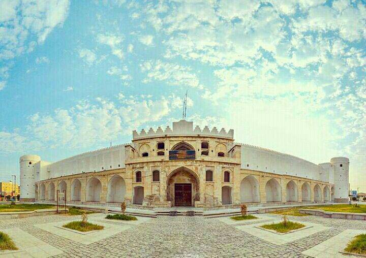
Borazjan Castle, Iran

Borazjan Castle

Caravanserai · Iran · 29.2673° N, 51.2084° E

Borazjan Castle (Persian: دژ برازجان) is a Qajar era castle and caravanserai located in Dashtestan County, Bushehr province, Iran. It was constructed during the reign of Naser al-Din Shah Qajar and is the only caravanserai in Iran built of stone and mortar.

Text from Wikipedia (CC BY-SA 4.0). Photo via Wikimedia Commons

Gouged Stronghold, Iran

Gouged Stronghold

Caravanserai · Iran · 33.4819° N, 50.3569° E

The Gouged stronghold (Persian: ارگ گوگد) is located in the city of Gouged, Golpayegan county, Iran. Gouged is located 5 km to the north of Golpayegan. In peacetime, the stronghold was used as a caravansary, but during war time or when bandits attacked, it was used as a castle. This structure is located in the Golpayegani alley and Ghale alley. At present, the stronghold is used as a traditional three star hotel. The Gouged stronghold is one of the biggest adobe and mud structures in Iran. It was built approximately 400 years ago. The only document related to this structure dates back to 140 years ago. By this document, Ali Khan Bakhtiari gave half of the stronghold to his wife as mahr.

Text from Wikipedia (CC BY-SA 4.0). Photo via Wikimedia Commons

Izadkhast Caravanserai, Iran

Izadkhast Caravanserai

Caravanserai · Iran · 31.5133° N, 52.1331° E

The Izadkhast Caravanserai (Persian: کاروانسرای ایزدخواست, lit. 'God Desire') is a historic site located in Izadkhast, Fars province, Iran. It was a caravanserai or roadside inn on the ancient Silk Road, serving caravaners and travelers as a place for rest and recovery during long journeys. It is situated in the historical complex of Izadkhast, lying in a natural low basin looking onto the Izadkhast Castle situated in the nearby high bedrock. Its construction dates to the early 17th century during the reign of Abbas the Great. Izadkhast Caravanserai is one of just 25 caravanserais on the UNESCO List of Persian Caravanserai from among hundreds of other caravanserais from all over Iran. The complex of Izadkhast with the Izadkhast Caravanserai and Izadkhast Castle has been on the UNESCO Tentative List for World Heritage status since 2007.

Text from Wikipedia (CC BY-SA 4.0). Photo via Wikimedia Commons

Jamalabad Caravanserai, Iran

Jamalabad Caravanserai

Caravanserai · Iran · 37.2719° N, 47.8431° E

Jamalabad Caravanserai (Persian: کاروانسرای جمال آباد) (Azerbaijani: جمال آباد کروانسراسی) is a historic caravanserai in Jamalabad, near Mianeh, Iran. It was originally constructed during the Ilkhanate, but was repaired during the reign of Shah Abbas II. Although the building is attributed to the Ilkhanate, the inscription on top of its gate attributes it to Abbas II, and cites the date of construction as 1654–55. This building was listed among the national heritage sites of Iran on 29 September 2002 with the number 6152.

Text from Wikipedia (CC BY-SA 4.0). Photo via Wikimedia Commons

Khajeh Nazar Caravansarai, Iran

Khajeh Nazar Caravansarai

Caravanserai · Iran · 38.9775° N, 45.5769° E

Khajeh Nazar Caravansarai (Persian: کاروانسرای خواجه نظر) is a restored caravanserai in East Azerbaijan province, Iran. It is located above a bend of the Aras border River 5 km west of the city of Jolfa. The caravanserai was registered on Iran's National Cultural Monument List in 2002 under the number 7744. In September 2023 it was inscribed as UNESCO World Heritage Site as one of the 54 Caravanserais of Iran with the registration number 1668-035.

Text from Wikipedia (CC BY-SA 4.0). Photo via Wikimedia Commons

Maranjab Caravansarai, Iran

Maranjab Caravansarai

Caravanserai · Iran · 34.2991° N, 51.8124° E

The Maranjab Caravansarai (Persian: کاروانسرای مرنجاب) is a Safavid era caravanserai in the Maranjab Desert, located to the north of the city of Aran and Bidgol in Isfahan province, Iran. In 1603, it was constructed by the order of Abbas the Great along the Silk Road between Khorasan and Isfahan provinces.

Text from Wikipedia (CC BY-SA 4.0). Photo via Wikimedia Commons

Ribat of Kabudan, Iran

Ribat of Kabudan

Caravanserai · Iran · 35.3768° N, 57.9779° E

Ribat of Kabudan (Persian: رباط کبودان) is a historical Ribat related to the Qajar dynasty and is located in Kabudan, Razavi Khorasan Province.

Text from Wikipedia (CC BY-SA 4.0). Photo via Wikimedia Commons

Safi Qoli Caravansarai, Iran

Safi Qoli Caravansarai

Caravanserai · Iran · 28.2510° N, 53.9823° E

The Safi Qoli Caravansarai (Persian: کاروانسرای صفی قلی) is a historical caravanserai related to the Safavid dynasty and is located in Juyom.

Text from Wikipedia (CC BY-SA 4.0). Photo via Wikimedia Commons

Sarayan Caravanserai, Iran

Sarayan Caravanserai

Caravanserai · Iran · 33.8552° N, 58.5180° E

Sarayan Caravanserai (Persian: کاروانسرای سرایان) is a caravanserai located in the city of Sarayan, South Khorasan province, Iran.

Text from Wikipedia (CC BY-SA 4.0). Photo via Wikimedia Commons

Titi Caravanserai, Iran

Titi Caravanserai

Caravanserai · Iran · 37.0447° N, 49.9022° E

The Titi Caravanserai (Persian and Gilaki: تی تی کاروانسرا) Is a Caravanserai in Siahkal County, Iran. Dating back to Safavid era, it was enlisted in the Iran national heritage sites list with the registration number 1784 on 2 December 1996.

Text from Wikipedia (CC BY-SA 4.0). Photo via Wikimedia Commons

Also recorded: Ab Bid Caravanserai, Abol-Fath Khan Caravanserai, Ahang Caravanserai, Al-Fath Khan Caravanserai, Aminabad Caravanserai, Anushirvan Caravanserai, Asef Caravanserai, Asemanjerd Caravanserai, Asfak Caravanserai, Aveh Caravanserai, Bagheri Caravanserai, Bahr-e Tork Caravanserai, Bastak Caravanserai, Beremir Caravanserai, Bersian Caravanserai, Chah Kuran Caravanserai, Chaleh Siah Caravanserai, Char Gonbad Caravanserai, Chenar Rahdar Caravanserai, Dalaki Caravanserai, Darband Caravanserai, Deh Bid Caravanserai, Deh-e Mohammad Caravanserai, Dehdasht Caravanserai, Dehshir Caravanserai, Do Dehak Caravanserai, Dokhan Caravanserai, Ein al-Rashid Caravanserai, Fakhrabad Caravanserai, Feyzabad Caravanserai, Feyzabad Caravanserai, Gaz Caravanserai, Guycheh Bil Caravanserai, Haj Kazem Modarresi Caravanserai, Haj Mehdi Caravanserai (Naraq), Hosnijeh Caravanserai, Hoz-e Panj Caravanserai, Imam Jomeh Caravanserai, Jahangiri Caravanserai, Jelogir Caravanserai, Kazemabad Caravanserai, Khajeh Abu al-Hassan Caravanserai, Khan Caravanserai, Kharanaq Caravanserai, Khargushi Caravanserai, Kheyrabad Caravanserai, Khushab Caravanserai, Komaraj Caravanserai, Konartakhteh Caravanserai, Kuhpayeh Caravanserai, Lar New Caravanserai, Lar Old Caravanserai, Lari Caravanserai, Lat Caravanserai, Madarshah Caravanserai, Mahak Caravanserai, Mahyar Caravanserai, Majd al-Mamalek Caravanserai, Malek Caravanserai (Isfahan), Malek Caravanserai (Zahedan), Marandiz Caravanserai, Mian Katal Caravanserai, Moin al-Tojar Caravanserai, Mokhak Caravansarai, Moshir Bridge Caravanserai, Motamed Caravanserai, Muzaffarid Caravanserai, Nikpey Caravanserai, Nusret Abad Caravanserai, Old Darband Caravanserai, Omrani Caravanserai, Picheh Bon Caravanserai, Piragaj Caravanserai, Qaleh-ye Shur Caravanserai, Qasemabad Caravanserai, Qasr-e Bahram Caravanserai, Qayelublagh Caravanserai, Qelli Caravanserai, Ravniz Caravanserai, Reza Qoli Khan Caravanserai, Robat-e Shur Caravanserai, Sabzeh Square Caravanserai, Sain Stone Caravanserai, Sarutaqi Caravanserai, Sefidab Caravanserai, Shah Abbasi Caravanserai of Khoy, Shah Abbasi Caravanserai of Payam, Shah Mansouri Caravanserai, Shotorkhaneh Caravanserai (Juyom), Soh Caravanserai, Tabasi Caravanserai, Tajavanchi Caravanserai, Tikmehdash Caravanserai, Tur Caravanserai, Zakikhani Caravanserai, Zanjan Stone Caravanserai, Zarnukh Caravanserai, Zerdan Caravanserai, Zeynabad Caravanserai

Azerbaijan (11)

Ashaghy caravanserai, Azerbaijan

Ashaghy caravanserai

Caravanserai · Azerbaijan · 41.2007° N, 47.1914° E

Ashaghy caravanserai or Lower Caravanserai (Azerbaijani: Aşağı karvansara) is a historical monument of the 17th century located in Azerbaijan, in the city of Sheki. The caravanserai is placed on a difficult terrain (the fast-flowing river Gurjanachay flows next to the caravanserai) and has the shape of a trapezoid. The total area of the building is about 8000 m2. It has a capacity of about 242 rooms. The caravanserai has entrance gates on four sides. When the gates were closed, the caravanserai turned into an inaccessible fortress. The Ashaghy Caravanserai, like the Upper Caravanserai, has preserved the traits inherent in the caravanserais of the East. The Lower and the Upper caravanserais, were built by local craftsmen, and in terms of their planning structure, large size and convenience for trade, are the largest ones recorded on the territory of Transcaucasia.

Text from Wikipedia (CC BY-SA 4.0). Photo via Wikimedia Commons

Caravanserai of Agha Gahraman Mirsiyab, Azerbaijan

Caravanserai of Agha Gahraman Mirsiyab

Caravanserai · Azerbaijan · 39.7500° N, 46.7500° E

Caravanserai of Agha Gahraman Mirsiyab Oghlu (Azerbaijani: Ağa Qəhrəman Mirsiyab oğlunun karvansarası, Armenian: Մասջիդլի քարավանատուն, Persian: کاروانسرای مسجدی) also known as the Masjidli Caravanserai, is located at 31 M.F. Akhundov Street in the city of Shusha. The caravanserai has been registered as an important historical and cultural monument of the country by the Ministry of Culture and Tourism of the Republic of Azerbaijan. The caravanserai was built in the 1880s with funds from the famous Shusha merchant Agha Gahraman Mirsiyab Oghlu. The main facade of the caravanserai, located near the edge of the steep rock, opens onto Rasta Bazaar Street, the central commercial street of Shusha. The second floor of the building had 25 rooms intended for merchants, while the first floor had commercial offices and nearly 30 shops. During the Soviet era, the caravanserai was used as a collective farm market.

Text from Wikipedia (CC BY-SA 4.0). Photo via Wikimedia Commons

Pir Huseyn Khanqah, Azerbaijan

Pir Huseyn Khanqah

Caravanserai · Azerbaijan · 40.1536° N, 49.0079° E

The Pir Huseyn Khanqah (Azerbaijani: Pir Hüseyn xanəgahı), also known as the Pirsaat or Pirsaatchay Khanqah (Azerbaijani: Pirsaatçay xanəgahı) and the Pir Huseyn Mausoleum, is a fortified Sufi khanqah and shrine complex of the 13th–14th centuries on the left bank of the Pirsaat River near the villages of Qubalıbalaoğlan and Navahı in Hajigabul District, Azerbaijan, about 126 kilometres southwest of Baku. It grew up around the grave of the Qalandari sheikh Pir Huseyn ibn Ali, who lived in the 11th century, and was built and endowed under the Shirvanshah Fariburz III (r. 1225–1255) at the crossroads of the medieval routes between Baku and Salyan. The complex is best known for its interior decoration in the Ilkhanid tradition of Iran: a monumental carved stucco mihrab dated 1266–67, and an extensive programme of lustre tiles made in Kashan in 1282–85 that covered the walls and cenotaph of the sheikh's tomb chamber.

Text from Wikipedia (CC BY-SA 4.0). Photo via Wikimedia Commons

Sangachal caravanserai, Azerbaijan

Sangachal caravanserai

Caravanserai · Azerbaijan · 40.1814° N, 49.4773° E

The Sangachal caravanserai (Azerbaijani: Sanqaçal karvansarası) is a medieval caravanserai located near the Sangachal village in the Garadagh district of Baku, Azerbaijan, 45 km far from Baku, on the old caravan route Baku - Salyan. Since the 19th century, the indicated caravan route has lost its commercial significance and in this regard, the caravanserai has ceased to be used.

Text from Wikipedia (CC BY-SA 4.0). Photo via Wikimedia Commons

Shah Abbas Caravanserai, Ganja, Azerbaijan

Shah Abbas Caravanserai, Ganja

Caravanserai · Azerbaijan · 40.6787° N, 46.3608° E

Shah Abbas Caravanserai was built in Ganja by the order of Iranian Shah Abbas. The caravansary was connected to Chokak Hamam and Shah Abbas Mosque by underground roads. The monument was included in the list of immovable historical and cultural monuments of national importance by the decision No. 132 issued by the Cabinet of Ministers of the Republic of Azerbaijan on August 2, 2001.

Text from Wikipedia (CC BY-SA 4.0). Photo via Wikimedia Commons

Two-Storeyed Caravanserai (Shusha), Azerbaijan

Two-Storeyed Caravanserai (Shusha)

Caravanserai · Azerbaijan · 39.7606° N, 46.7522° E

Two-Storeyed Caravanserai (Azerbaijani: İkimərtəbəli karvansara, Armenian: Երկհարկանի քարավանատուն, Persian: کاروانسرای دو طبقه) is a caravanserai built in Shusha in the 19th century. It is a two-storeyed hotel-style caravanserai in the Sheytan Bazaar part of Shusha.

Text from Wikipedia (CC BY-SA 4.0). Photo via Wikimedia Commons

Upper Caravanserai (Shaki), Azerbaijan

Upper Caravanserai (Shaki)

Caravanserai · Azerbaijan · 41.2011° N, 47.1936° E

The Upper Caravanserai (Azerbaijani: Yuxarı Karvansaray) is a historical monument in Sheki, Azerbaijan. A part of the building is now used as a hotel.

Text from Wikipedia (CC BY-SA 4.0). Photo via Wikimedia Commons

Garghabazar Caravanserai

Caravanserai · Azerbaijan · 39.5384° N, 47.1572° E

Garghabazar caravanserai (Azerbaijani: Qarğabazar karvansarayı) is a historic monument of XVII century. It is located in Garghabazar village, of Fuzuli District, in Azerbaijan.

Text from Wikipedia (CC BY-SA 4.0)

Khanlig Mukhtar caravanserai

Caravanserai · Azerbaijan · 39.7631° N, 46.7508° E

Khanlig Mukhtar caravanserai (Azerbaijani: Xanlıq Muxtar karvansarası, Persian: کاروانسرای خانلیق مختار) is a nationally important caravanserai belonging to the Shusha State Historical-Architectural Reserve, located at 29 M.F. Akhundov Street, Shusha. The caravansary was registered by the Ministry of Culture and Tourism of the Azerbaijan Republic as a historical and cultural monument of national importance.

Text from Wikipedia (CC BY-SA 4.0)

Also recorded: Girik Caravanserai, Ugurlu Khan Caravanserai

Armenia (6)

Jrapi Caravansarai, Armenia

Jrapi Caravansarai

Caravanserai · Armenia · 40.5537° N, 43.6959° E

The Jrapi Caravansarai is a medieval caravansarai located near Jrapi, Armenia. The Jrapi structure is similar to the Aruch Caravansarai, with the latter featuring stone arches, three parallel chambers, and a single entrance for people and animals. In the 1970s, the Jrapi Caravansarai was moved in its entirety to its current location due to the damming of the Akhurian River. The caravansarai is currently adjacent to two medieval church buildings.

Text from Wikipedia (CC BY-SA 4.0). Photo via Wikimedia Commons

Orbelian's Caravanserai, Armenia

Orbelian's Caravanserai

Caravanserai · Armenia · 39.9495° N, 45.2367° E

Orbelian's Caravanserai (Armenian: Օրբելյանների Քարվանսարա; also known as Selim Caravanserai, Armenian: Սելիմ), is a caravanserai in the Vayots Dzor Province of Armenia. It was built along the Vardenyats Mountain Pass (also known as the Selim Mountain Pass) in 1332, by prince Chesar Orbelian to accommodate weary travelers and their animals as they crossed from, or into, the mountainous Vayots Dzor region. Located at the southern side of Vardenyats Mountain Pass at a height of 2,410 metres (7,910 ft) above sea level, it has been described as perhaps the best-preserved caravanserai among Armenia's medieval monuments.

Text from Wikipedia (CC BY-SA 4.0). Photo via Wikimedia Commons

Talin Caravansarai, Armenia

Talin Caravansarai

Caravanserai · Armenia · 40.3660° N, 43.8630° E

The Talin Caravansarai was a 13th century caravansarai located south of Talin, Armenia. The structure dates to the period of the Zakarid Dynasty and was a component of the Seljuk-inspired caravansarai network built by the Zakarids. This network was intended to draw trade towards Ani, and it also included sites like the Aruch Caravansarai. The rectangular structure near Talin is considered large for its type, and it consists of a central common area flanked by two dormitory-like structures. It is a ruin in the modern period.

Text from Wikipedia (CC BY-SA 4.0). Photo via Wikimedia Commons

Also recorded: Agarak caravanserai, Aruch Caravansarai, Caravanserai in Bardzravan

India (6)

Taramati Baradari, India

Taramati Baradari

Caravanserai · India · 17.3761° N, 78.3781° E

Taramati Baradari is a historical sarai as part of Ibrahim Bagh, a Persian style garden built during the reign of Ibrahim Quli Qutub Shah, the fourth Sultan of Golconda.

Text from Wikipedia (CC BY-SA 4.0). Photo via Wikimedia Commons

Also recorded: Ajanta Sarai, Akbari Sarai, Madankui Sarai, Pardapur Sarai, Teli ki Sarai

Georgia (5)

Alexander Mantashev's Caravanserai, Artsruni Caravanserai, Maisuradze-Khojaparukov Caravanserai, Princess Tekle's Caravanserai, Seilanovs' Caravanserai

North Macedonia (4)

Kapan Han, North Macedonia

Kapan Han

Caravanserai · North Macedonia · 42.0000° N, 21.4367° E

Kapan Han (Macedonian: Капан ан, romanized: Kapan an, Albanian: Hani i Kapanit, Turkish: Kapan Han) is a han (caravanserai) in the Old Bazaar of Skopje, North Macedonia. It was built in the mid-15th century by Bosnian general Isa-Beg Isaković, ruler of Skopsko Krajište, in order to provide a regular source of income for his endowment (vakuf).

Text from Wikipedia (CC BY-SA 4.0). Photo via Wikimedia Commons

Kuršumli An, North Macedonia

Kuršumli An

Caravanserai · North Macedonia · 42.0031° N, 21.4369° E

Kursumli An (Macedonian: Куршумли ан, Albanian: hani i Kurshumlis, Turkish: Kurşunlu han) is an Ottoman caravanserai located in the Old Town of Skopje. It is in the area of Museum of Macedonia. It has served as an inn and as a prison. Kursumli An was built in the 15th or 16th century. There were stables for 100 horses. The walls form a square but roof consists of pyramid-shaped domes. The domes were originally covered in lead, and this is why the serai is called "Lead Bazaar." Ground floor rooms were used for storage, upper floor for sleeping quarters. The building also featured rooms for livestock.

Text from Wikipedia (CC BY-SA 4.0). Photo via Wikimedia Commons

Suli An, North Macedonia

Suli An

Caravanserai · North Macedonia · 42.0017° N, 21.4378° E

The Suli An (Macedonian: Сули ан, Albanian: Hani i Sulit, Turkish: Sulu Han) is a han in the Old Bazaar of Skopje, North Macedonia. It was built in the mid-15th century by Isa-Beg Isaković. Today, the building houses the permanent exhibition History of the Old Bazaar of the Museum of the City of Skopje.

Text from Wikipedia (CC BY-SA 4.0). Photo via Wikimedia Commons

Also recorded: Kuršumli An, Prilep

Lebanon (4)

Khan al-Franj, Lebanon

Khan al-Franj

Caravanserai · Lebanon · 33.5642° N, 35.3698° E

Khan al-Franj (Arabic: خان الفرنج) is an Ottoman caravanserai in Sidon, Lebanon. The founding of the structure is traditionally attributed to the Druze emir Fakhr al-Din II, but its construction was ordered earlier, in the late 16th century by Grand Vizier Sokullu Mehmed Pasha. Its name is owed to the French (called al-Franj in Arabic) merchants it housed in the 17th century. It currently functions as a cultural center and is owned by the French government, which has leased it to the Hariri Foundation.

Text from Wikipedia (CC BY-SA 4.0). Photo via Wikimedia Commons

Also recorded: Khan al-Sabun, Khan Rabu, Tyre, Khan Sour, Tyre

Israel (3)

Good Samaritan Museum, Jerusalem Khan Theater, Khan al-Sultan

Greece (3)

Khan of Emin Aga, Khan of Gravia, Moustafabey caravanserai

Cyprus (2)

Büyük Han, Cyprus

Büyük Han

Caravanserai · Cyprus · 35.1763° N, 33.3625° E

Büyük Han (lit. 'Great Inn') (Greek: Μεγάλο Πανδοχείο, romanized: Megálo Pandocheío) is the largest caravansarai on the island of Cyprus and is considered to be one of the finest buildings on the island. Located in the capital of Cyprus, it was built by the Ottomans in 1572, the year after they had seized Cyprus from the Venetians. In the centre of the open courtyard is a mosque with a fountain for pre-prayer ablutions. It became the first city prison under British administration. After spending most of the 1990s being restored, the inn has been revived as a thriving arts centre, consisting of several galleries and workshops. There are also several courtyard cafes and souvenir shops.

Text from Wikipedia (CC BY-SA 4.0). Photo via Wikimedia Commons

Kumarcilar Han, Cyprus

Kumarcilar Han

Caravanserai · Cyprus · 35.1771° N, 33.3627° E

Kumarcilar Han (Gambler's Inn) is a caravansarai located in North Nicosia, Northern Cyprus. It is unknown when exactly it was built, however it is thought to be built around the end of the 17th century, is much smaller and modest when compared with Büyük Han (Great Inn). Similar to all caravansarai, the entrance leads to an open-air courtyard, which is surrounded by a two-storey building, originally containing 56 rooms. Those on the upper story were used by the travelers, while those on the ground floor were used for their animals and belongings. The building was in a state of disrepair and in danger of collapsing for centuries. Efforts to restore the building have been hampered often, due to lack of funds. As at January 2018, the Kumarcilar Han has been fully restored, and is used as a cafe/restaurant, as well as small shops selling local items. According to Haşmet Muzaffer Gürkan, the door of the caravenserai "indubitably" used to belong to a Latin building. A hypothesis about its name states that it was originally called "Kumbaracılar Hanı", after a subdivision of the Ottoman army, "kumbaracılar".

Text from Wikipedia (CC BY-SA 4.0). Photo via Wikimedia Commons

Serbia (2)

Stari Han, Serbia

Stari Han

Caravanserai · Serbia · 43.8389° N, 19.5750° E

The Stari Han (Serbian Cyrillic: Стари хан) is a former caravanserai in Kremna, Užice municipality, southwestern Serbia. It was listed as a Cultural Monument of Exceptional Importance.

Text from Wikipedia (CC BY-SA 4.0). Photo via Wikimedia Commons

Also recorded: Han Pantića

Palestine (2)

Inn of the Good Samaritan, Palestine

Inn of the Good Samaritan

Caravanserai · Palestine · 31.8164° N, 35.3594° E

The Inn of the Good Samaritan (Hebrew: אכסניית השומרוני הטוב; Arabic: خان الحترورة) is a national park, museum, ancient archaeological site and former inn administered by the Israel Nature and Parks Authority located near Ma'ale Adumim, halfway between Jerusalem and Jericho, at an elevation of 298 metres above sea level. The Inn is named after the New Testament's Parable of the Good Samaritan, and houses a museum of ancient mosaics and other archaeological findings mostly dating from the 4th-7th centuries that were collected from churches and Jewish and Samaritan synagogues from the West Bank and from the ancient Gaza synagogue. Beginning in biblical times, Israelite and later Jewish pilgrims from Galilee took the Jericho-Jerusalem road passing by the site to worship at the Temple in Jerusalem. In later times, Christian pilgrims used the road to reach the baptismal site of Jesus on the Jordan River near Jericho (see here and here). The area of the Inn of the Good Samaritan was repeatedly fortified, and traveller inns were built a little below the hilltop.

Text from Wikipedia (CC BY-SA 4.0). Photo via Wikimedia Commons

Khan al-Ahmar (village), Palestine

Khan al-Ahmar (village)

Caravanserai · Palestine · 31.8125° N, 35.3378° E

Khan al-Ahmar (Arabic: الخان الأحمر, Hebrew: חאן אל-אחמאר, lit. The Red Caravansary) is a Palestinian village (sometimes referred to as the "Khan al-Ahmar school community") located in the Khan al-Ahmar area of the Jerusalem Governorate of the West Bank. In 2018, there were between 173 and 180 Bedouin, including 92 children, living there in tents and huts, upwards of 100 in 2010, with its local school serving the needs of 150 children in the area. Khan al-Ahmar is located between the Israeli settlements of Ma'ale Adumim and Kfar Adumim on the north side of Highway 1, between the junctions with Route 437 and Route 458. In May 2018, the Israeli High Court of Justice determined that its residents could be evicted. The United Nations, the International Criminal Court, the European Parliament and Amnesty International have stated that the demolition of the village would be a violation of international law, being a breach of the Fourth Geneva Convention, and may amount to a war crime. On 20 October 2018, the Israeli government announced that it would postpone the demolition.

Text from Wikipedia (CC BY-SA 4.0). Photo via Wikimedia Commons

Bulgaria (2)

Karavansaray, Yeni Han

Romania (1)

Manuc's Inn, Romania

Manuc's Inn

Caravanserai · Romania · 44.4296° N, 26.1020° E

Manuc's Inn (Romanian: Hanul lui Manuc, pronounced [ˈhanu(l) luj maˈnuk]) is the oldest operating hotel building in Bucharest, Romania. It also houses a popular restaurant, several bars, a coffee-house, and (facing the street) several stores and an extensive bar. Its massive, multiply balconied courtyard hosted many performances and fairs, and was a popular place for Romanian Television crews to shoot folkloric performances. The hotel and restaurant were refurbished in 2007.

Text from Wikipedia (CC BY-SA 4.0). Photo via Wikimedia Commons

Bosnia and Herzegovina (1)

Morića Han, Bosnia and Herzegovina

Morića Han

Caravanserai · Bosnia and Herzegovina · 43.8597° N, 18.4302° E

Morića Han is a han (a roadside inn) originally built in 1551 in Sarajevo, Ottoman Empire (now Bosnia and Herzegovina). After a fire in 1697 it was reconstructed in its current form. Morića Han is one of the buildings which were financed by and belonged to Gazi Husrev-Beg's endowment (Vakuf). It is the only surviving han in Sarajevo. It is located in Baščaršija, Sarači street, in Stari Grad. Morića Han (also spelled "khan" when translated to English) is considered a true caravanserai because, when operational, it could accommodate about 300 passengers and 70 horses. Evliya Çelebi, an Ottoman traveller, wrote about his visit to Sarajevo in 1659 and described Morića Han as Hadži-Bešir's han, because Hadži-Bešir was landlord of the han then. The modern name probably comes from the surname of the han's tenants at the beginning of the 19th century, Mustafa-aga Morić and his son Ibrahim-aga Morić. However, some sources connect the name of this han with the Morić brothers who participated in rebellions against the Ottoman Empire from 1747 to 1757.

Text from Wikipedia (CC BY-SA 4.0). Photo via Wikimedia Commons

Uzbekistan (1)

Rabati Malik, Uzbekistan

Rabati Malik

Caravanserai · Uzbekistan · 40.1222° N, 65.1474° E

Rabati Malik, also called Ribat-i Malik, is a caravanserai ruin located on the M37 road from Samarkand to Bukhara about a kilometer west of the edge of Malik, Navoiy Province, Uzbekistan. It was constructed along the Silk Road according to the orders of Karakhanid Shams al-Mulk Nasr, son of Tamgachkhan Ibragim, who ruled in Samarkand from 1068 until 1080.

Text from Wikipedia (CC BY-SA 4.0). Photo via Wikimedia Commons

Russia, Ukraine (1)

Tash han karavansaray, Belogorsk

Croatia (1)

Maškovića Han

Turkmenistan (1)

Dayahatyn, Turkmenistan

Dayahatyn

Caravanserai · Turkmenistan · 40.0746° N, 62.3988° E

Daýahatyn (Turkmen pronunciation: [dɑːˌjɑχɑːˈtɯn]), also spelled Dayakhatun (Persian: دایه‌خاتون), is a medieval caravanserai, sitting on the left bank of the Amu Darya. It is around 170 kilometres (110 mi) to the northwest of Turkmenabat, near the Turkmenistan–Uzbekistan border. Daýahatyn is a fortified square enclosure with sides 53 metres (174 ft) long. It is believed to have been originally a fortress built by Tahir ibn Husayn in the 9th century. In the 11th century, it was transformed into a caravanserai with fascinating brick-structures, providing shelter for not only caravans but also elites during their long journeys. The integrity of Daýahatyn is a typical example of the mastery of Seljuk architects in brickwork during the 11th and 12th centuries. Because of its artistic excellence, Daýahatyn is regarded as one of the most valuable examples, and perhaps the finest example, of a caravanserai extant in Central Asia, aside from that of Ribat of Sharaf.

Text from Wikipedia (CC BY-SA 4.0). Photo via Wikimedia Commons

Syria (1)

Caravanserai of Qalat el-Mudiq

Egypt (1)

Wikalat al-Jidawi

Tajikistan (1)

Tohir Caravansarai