Every day from the invasion of Poland to Japan’s surrender: who held what, the front lines and every battle as it happened.
Loading map…
AlliesAxisSoviet Union (before June 1941)Neutral / not at warOccupiedContested
1939194019411942194319441945
Drag the slider or press ←→ to move a day (Shift for a month) · Space to play
How to use the World War II map
This interactive map follows World War II one day at a time, from the German invasion of Poland on 1 September 1939 to Japan’s formal surrender on 2 September 1945. Move the slider and the map redraws who held every region of Europe, Africa and Asia on that date: Axis and Allied territory, neutral states, occupied countries, puppet governments and the land being fought over.
Borders are drawn as they stood before the war, so you can see each conquest and liberation against the map people knew. The panel beside the map lists every battle, campaign, bombing raid, naval action and political event that began that day, together with the operations still under way. Select any event to read a summary and see where it happened.
2,194 days, 1939-09-01 to 1945-09-02
2,122 dated events
77 states and territories at war
314 changes of alignment
Turning points of World War II
Each turning point below opens the map on the day it happened.
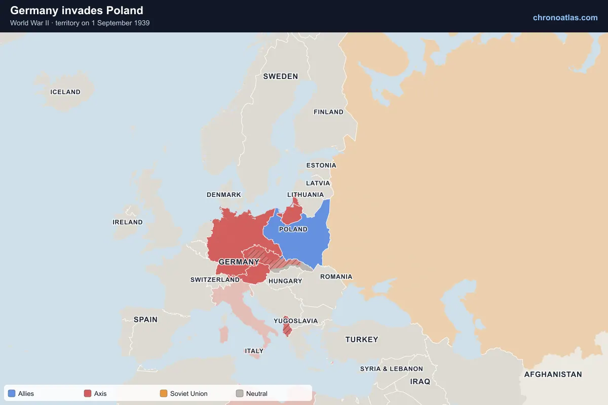
Germany invades Poland
Europe, 1 September 1939: territory held by each side.
German forces crossed into Poland at dawn on 1 September 1939, and the Free City of Danzig was annexed the same day. Britain and France declared war on 3 September but could do little to help. Polish armies were broken in the west within ten days, and Warsaw surrendered on 28 September after a heavy siege. On the map, Poland’s western regions turn German week by week, and the corridor and Silesia fall first.
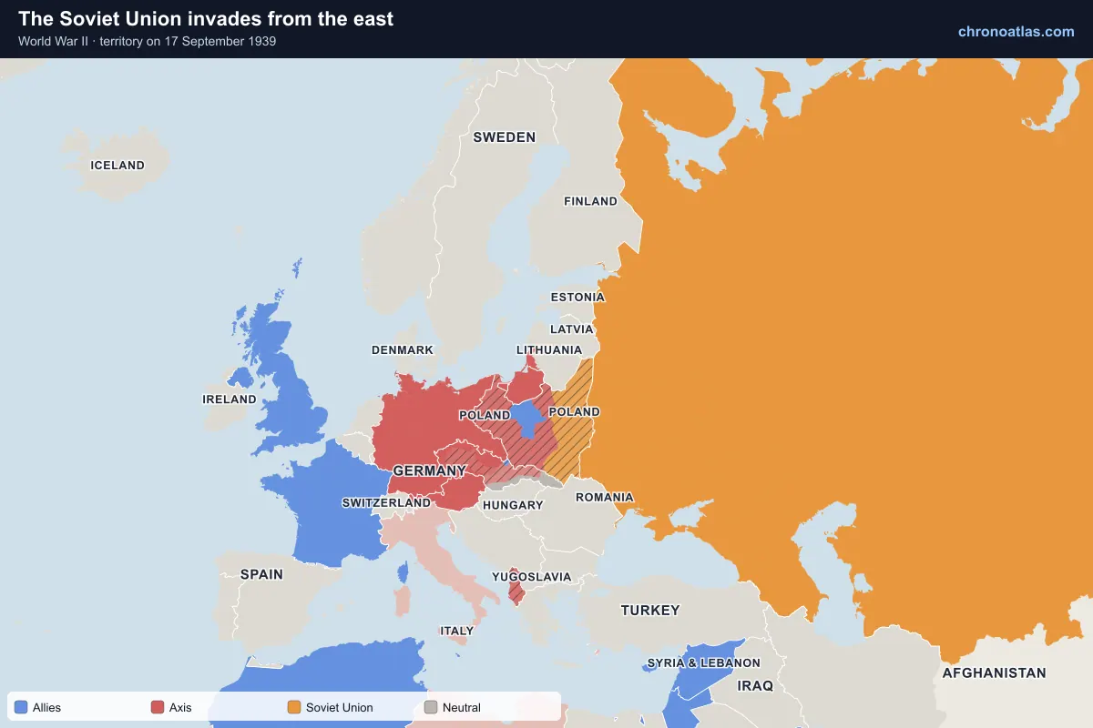
Europe, 17 September 1939: territory held by each side.
Under the secret protocol of the Molotov–Ribbentrop Pact, the Red Army entered eastern Poland on 17 September. The country was partitioned along the Bug river: Germany annexed the west outright and ran the centre as the General Government, while the Soviet Union annexed the east in November. The Soviets passed Vilnius to Lithuania, then occupied and annexed all three Baltic states in the summer of 1940.
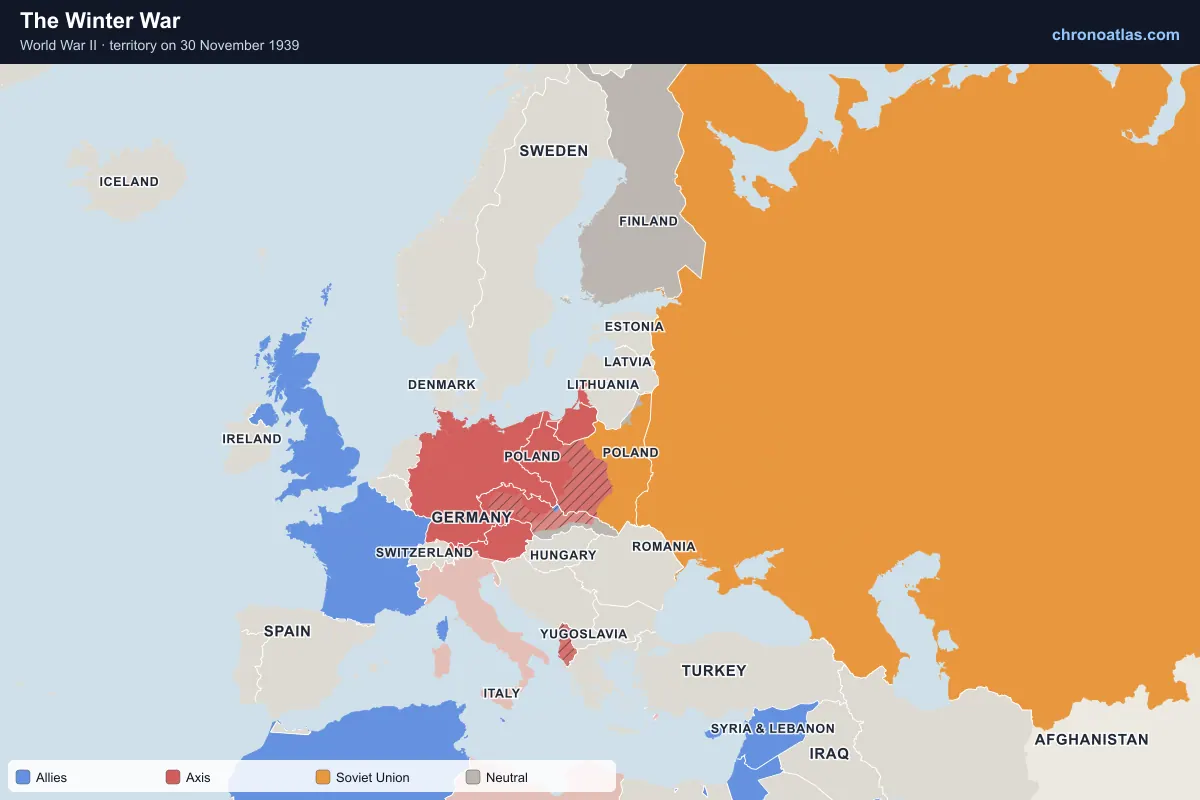
Europe, 30 November 1939: territory held by each side.
The Soviet Union attacked Finland on 30 November 1939. Heavily outnumbered, the Finns held the Mannerheim Line through the winter and inflicted severe losses before the Moscow Peace Treaty of March 1940. Finland kept its independence but gave up the Karelian Isthmus and Vyborg, shown changing hands on 13 March 1940. Finland would retake the land in 1941 as Germany’s co-belligerent.
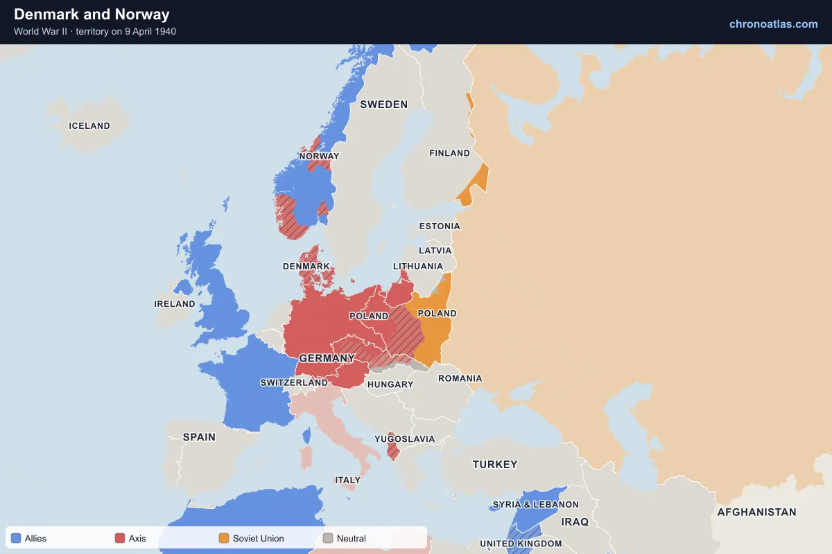
Europe, 9 April 1940: territory held by each side.
On 9 April 1940 Germany occupied Denmark in a single morning and landed at every major Norwegian port from Oslo to Narvik. British, French and Polish troops fought in central and northern Norway, briefly retaking Narvik, but were withdrawn as France collapsed. Norway capitulated on 10 June; its king and government continued the war from London.
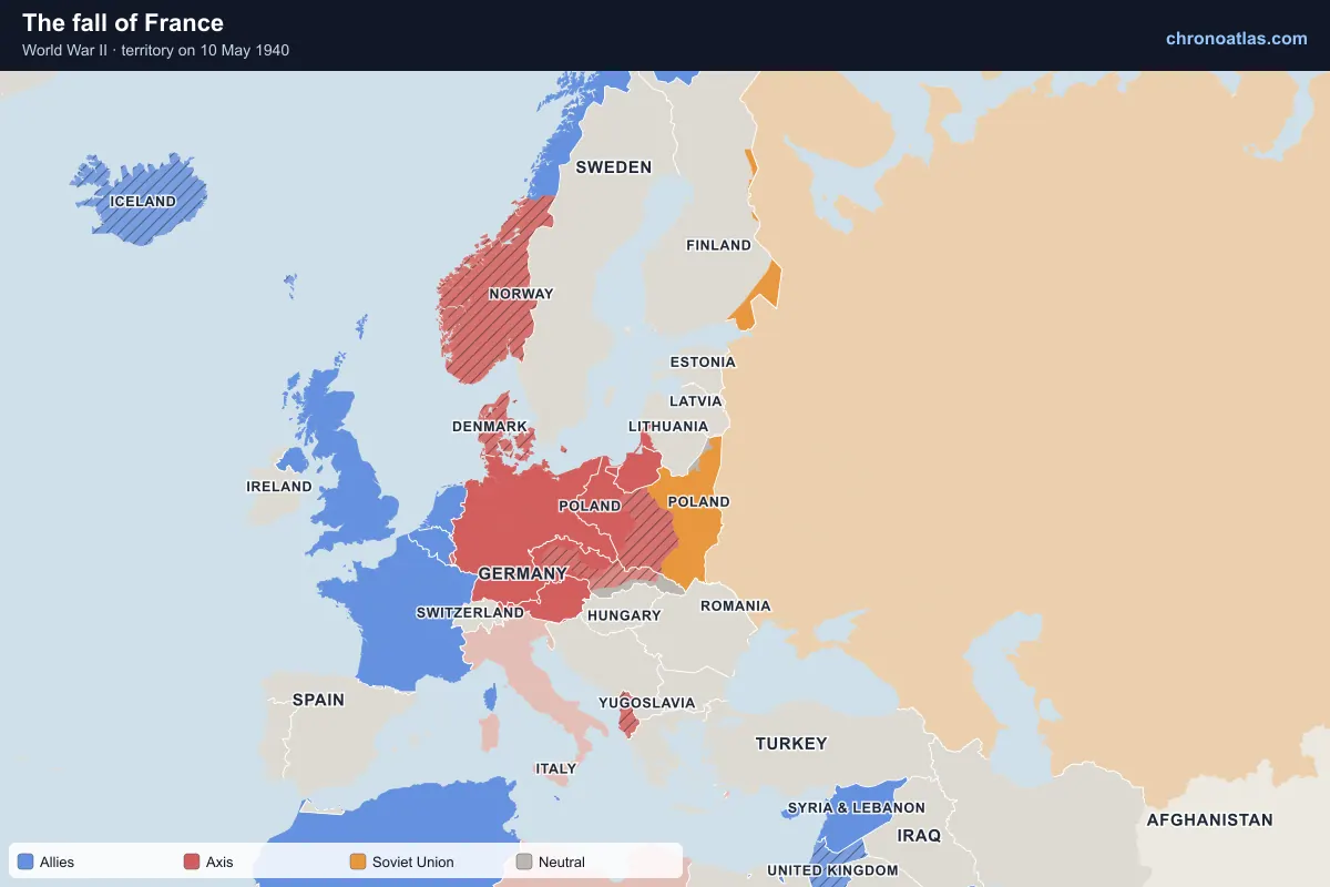
Germany attacked the Netherlands, Belgium, Luxembourg and France on 10 May 1940. Panzer divisions broke through the Ardennes at Sedan and reached the Channel in ten days, trapping Allied armies in Flanders; more than 330,000 troops were evacuated from Dunkirk. Paris fell on 14 June. The armistice of 22 June split France into a German-occupied north and west and an unoccupied zone governed from Vichy, with Alsace-Lorraine annexed in all but name.
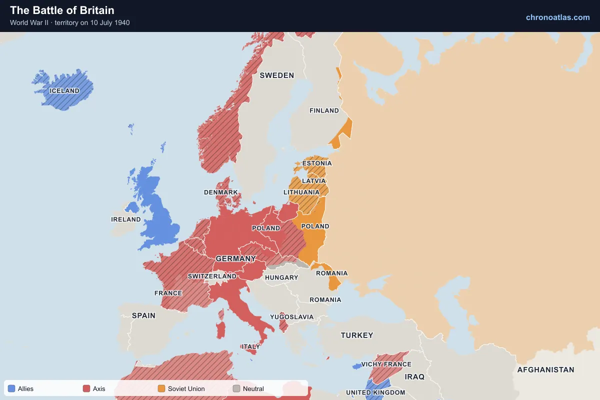
Europe, 10 July 1940: territory held by each side.
From July to October 1940 the Luftwaffe tried to win the air superiority needed to invade Britain. RAF Fighter Command, supported by radar, held on; by mid-September the invasion was postponed indefinitely and the bombing turned to the night Blitz on British cities. It was Germany’s first major defeat and kept Britain in the war as the base for the later liberation of Europe.
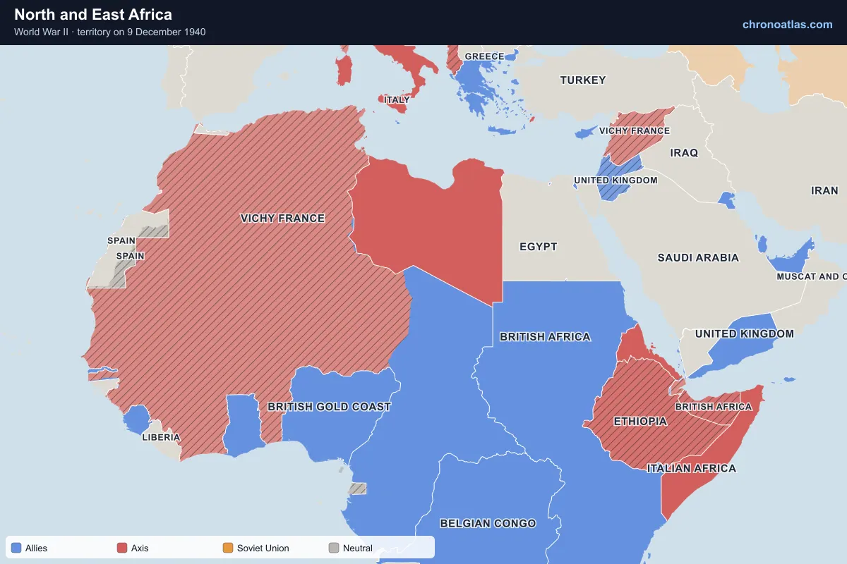
Africa, 9 December 1940: territory held by each side.
Italy’s invasion of Egypt stalled, and Britain’s Operation Compass in December 1940 destroyed an Italian army and took Cyrenaica. Germany sent Rommel’s Afrika Korps, and the desert front swung back and forth across Libya for two years. In East Africa, British and Commonwealth forces took Italian Somaliland and Eritrea, and Haile Selassie returned to Addis Ababa on 5 May 1941.
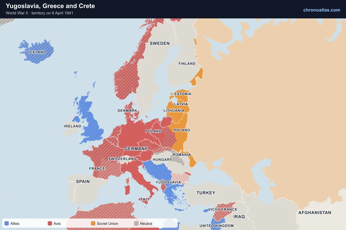
Europe, 6 April 1941: territory held by each side.
Germany, with Italy and Hungary, invaded Yugoslavia and Greece on 6 April 1941. Yugoslavia surrendered in eleven days and was carved up: a puppet Independent State of Croatia, German-run Serbia, and annexations by Italy, Hungary and Bulgaria. Athens fell on 27 April and Crete to an airborne assault by 1 June. Resistance movements, above all Tito’s Partisans, tied down large Axis forces for the rest of the war.
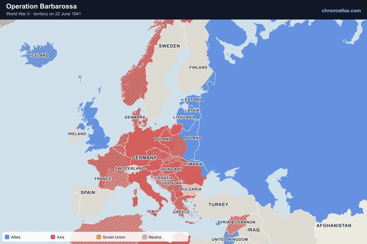
Europe, 22 June 1941: territory held by each side.
More than three million Axis troops invaded the Soviet Union on 22 June 1941, the largest invasion in history. The Baltic states, Belarus and most of Ukraine were overrun by autumn: Minsk fell in six days, Kiev in September with over 600,000 prisoners, and Leningrad was besieged from 8 September. The Soviet Union joined the Allies, and on the map changes colour on the first day. The advance was stopped at the gates of Moscow in December.
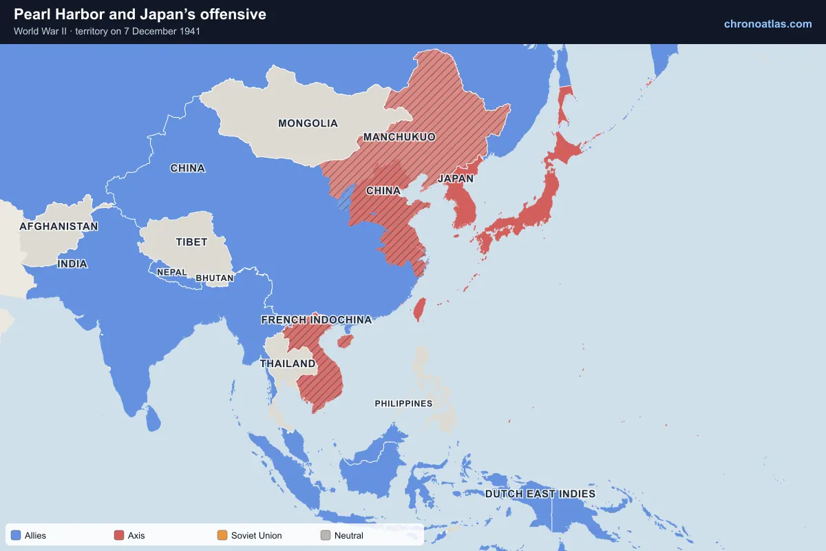
East and South-East Asia, 7 December 1941: territory held by each side.
Japan attacked the US fleet at Pearl Harbor on 7 December 1941 and struck Malaya, Hong Kong, the Philippines and Guam within hours. The United States entered the war the next day. In five months Japan took Malaya and Singapore, the Dutch East Indies, the Philippines and Burma, reaching the borders of India and the approaches to Australia. Watch South-East Asia change hands between December 1941 and May 1942.
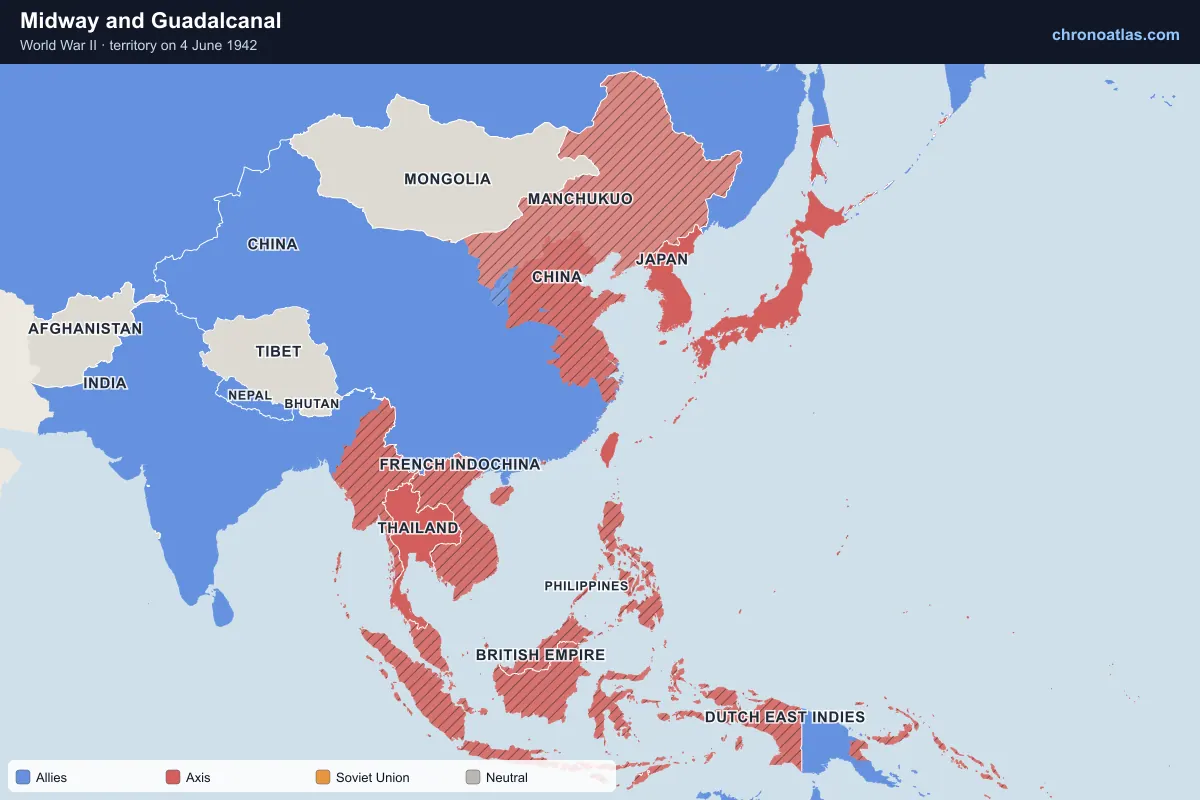
East and South-East Asia, 4 June 1942: territory held by each side.
At Midway in June 1942 the US Navy sank four Japanese fleet carriers, ending Japan’s ability to take the offensive at sea. In August US Marines landed on Guadalcanal, beginning a six-month struggle for the Solomon Islands that Japan finally abandoned in February 1943. In New Guinea, Australian troops halted the Japanese advance on Port Moresby along the Kokoda Track.
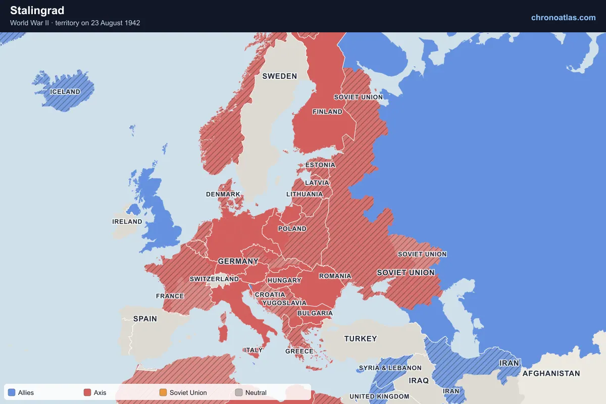
Europe, 23 August 1942: territory held by each side.
Germany’s 1942 summer offensive drove to the Volga and into the Caucasus, the high-water mark of the Axis in Europe. The battle for Stalingrad began on 23 August; in November the Red Army encircled the German Sixth Army, which surrendered on 2 February 1943. The map shows the Axis at its greatest extent in late 1942, then the first great rollback through the North Caucasus and the Don.
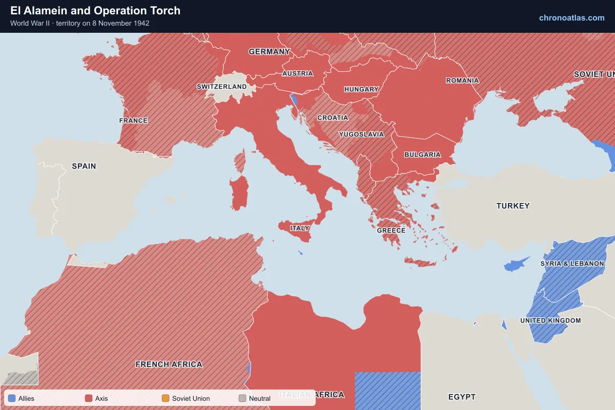
the Mediterranean, 8 November 1942: territory held by each side.
Montgomery’s Eighth Army broke Rommel’s line at El Alamein in early November 1942, and on 8 November Anglo-American forces landed in Vichy-held Morocco and Algeria. Germany responded by occupying the rest of France and pouring troops into Tunisia. Squeezed from east and west, the Axis armies in Africa surrendered on 13 May 1943.
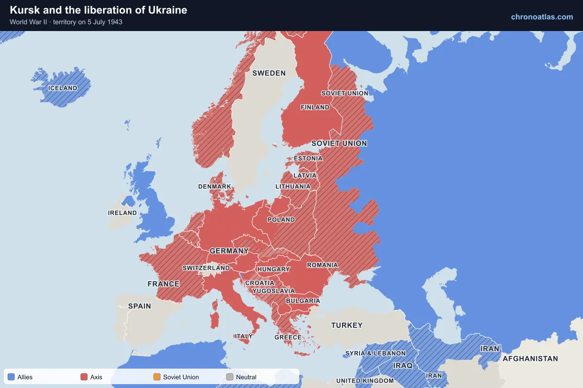
Germany’s last great summer offensive in the east, at Kursk in July 1943, failed against deep Soviet defences. The Red Army went over to the attack and did not stop: Kharkiv, Smolensk and Kiev were liberated by November, and most of Ukraine and Crimea by May 1944. The siege of Leningrad was finally lifted on 27 January 1944 after almost 900 days.
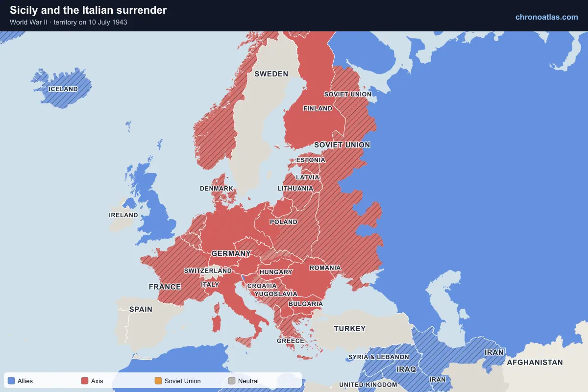
Europe, 10 July 1943: territory held by each side.
The Allies invaded Sicily on 10 July 1943; Mussolini was deposed two weeks later. Italy surrendered on 8 September as the Allies landed on the mainland, and Germany immediately occupied the centre and north, installing Mussolini at the head of the puppet Italian Social Republic. The Allies fought slowly up the peninsula: Rome fell on 4 June 1944, but northern Italy was freed only in April 1945.
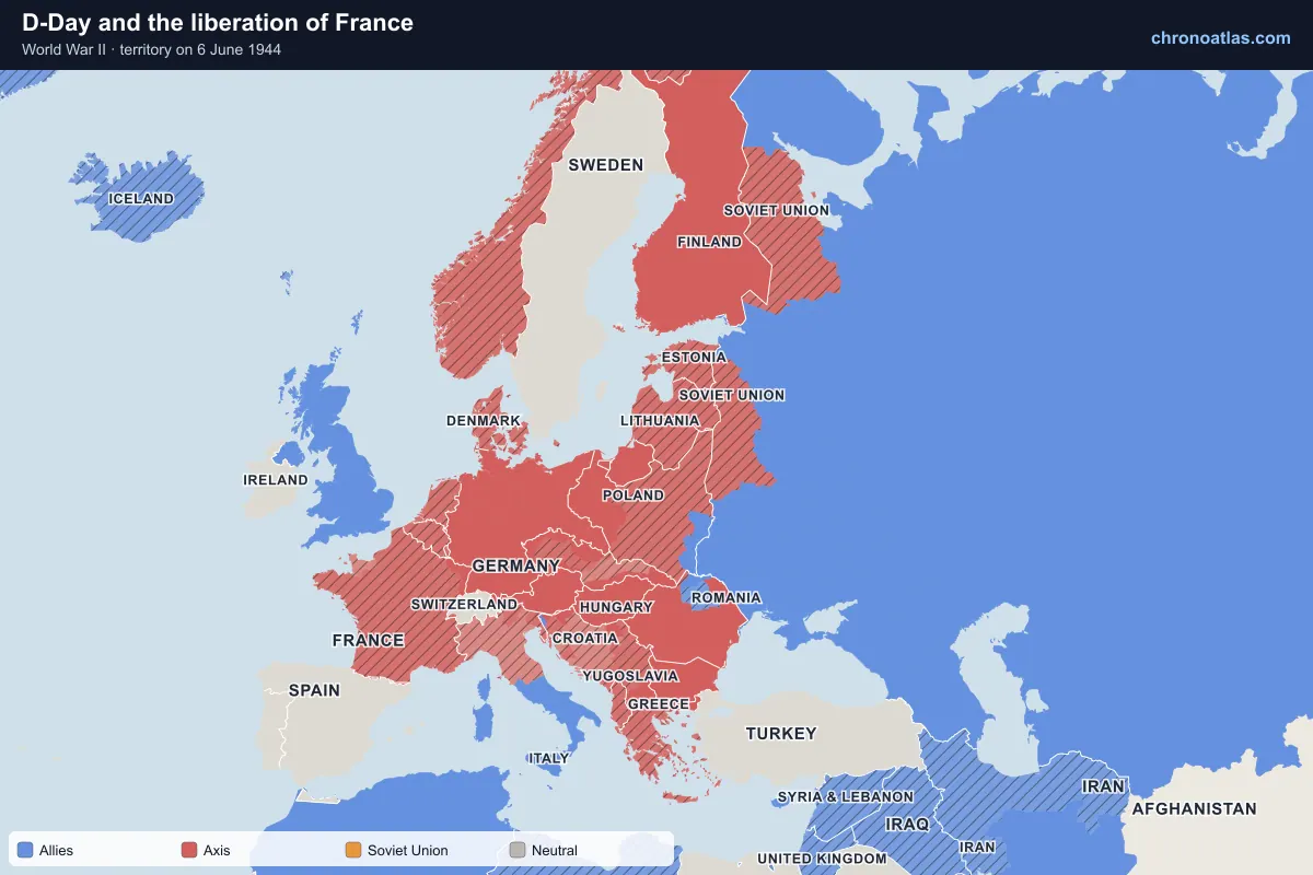
On 6 June 1944 Allied forces landed on five beaches in Normandy, the largest seaborne invasion in history. After weeks of fighting in the hedgerows they broke out in late July; Paris was liberated on 25 August, while landings in Provence freed the south. By September most of France and Belgium were free, shown department by department on the map.
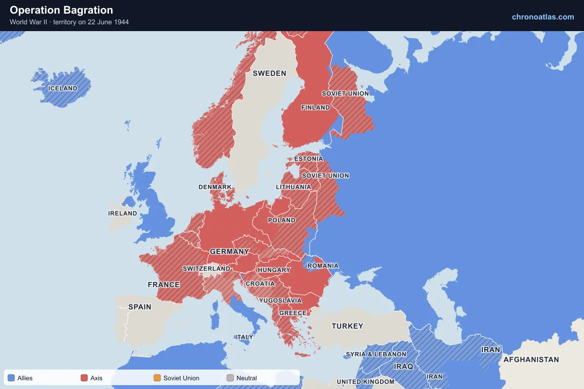
Europe, 22 June 1944: territory held by each side.
Three years to the day after Barbarossa, the Red Army destroyed German Army Group Centre in Belarus. Minsk was retaken on 3 July and Soviet forces reached the Vistula and the edge of East Prussia by August. Romania changed sides on 23 August and Bulgaria in September, opening the Balkans; Belgrade was liberated in October.
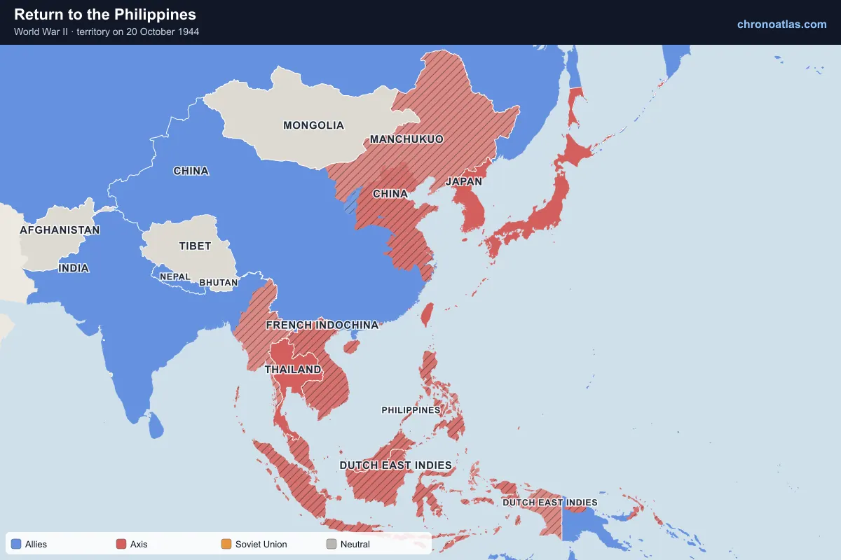
East and South-East Asia, 20 October 1944: territory held by each side.
US forces landed on Leyte on 20 October 1944, and the Battle of Leyte Gulf that followed destroyed most of what remained of the Japanese navy. Luzon was invaded in January 1945 and Manila was retaken in March after a month of street fighting. Meanwhile British and Indian forces reconquered Burma, retaking Rangoon in May 1945.
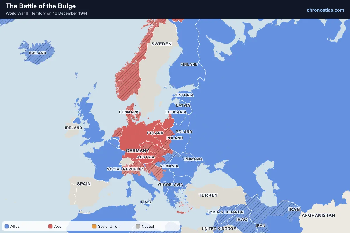
Europe, 16 December 1944: territory held by each side.
Germany’s surprise offensive through the Ardennes in December 1944 drove a salient into the American lines but ran out of fuel and momentum within weeks. In January 1945 the Red Army launched its offensive from the Vistula, liberating Warsaw on 17 January and Auschwitz on 27 January and reaching the Oder, 70 km from Berlin.
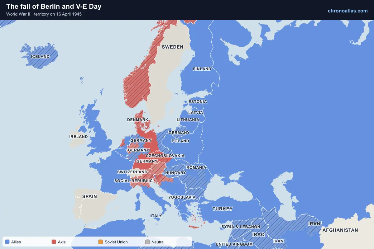
Europe, 16 April 1945: territory held by each side.
The Western Allies crossed the Rhine in March 1945 and the Soviet assault on Berlin began on 16 April. American and Soviet troops met on the Elbe at Torgau on 25 April; Hitler killed himself on 30 April and Berlin surrendered on 2 May. Germany’s unconditional surrender took effect on 8 May 1945. The map shows each German region passing to Allied occupation.
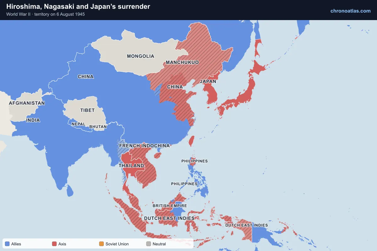
East and South-East Asia, 6 August 1945: territory held by each side.
After the capture of Iwo Jima and Okinawa, the United States dropped atomic bombs on Hiroshima on 6 August and Nagasaki on 9 August 1945; the Soviet Union declared war and invaded Manchuria on 9 August. Japan announced its surrender on 15 August and signed the instrument of surrender aboard USS Missouri on 2 September 1945, the last day of the timeline.
Every state and territory the map shows at war, with the date it entered and the date it left the war (armistice, surrender or peace). Dates link to the map.
World War II began on 1 September 1939, when Germany invaded Poland; Britain and France declared war two days later. It ended in Europe on 8 May 1945 and in Asia with Japan’s formal surrender on 2 September 1945. The war between Japan and China had already been under way since July 1937.
Who were the Allies and the Axis powers?
The main Allies were the United Kingdom and its Commonwealth, France (and later Free France), the Soviet Union from June 1941, the United States from December 1941, and China. The main Axis powers were Germany, Italy and Japan, joined by Hungary, Romania, Bulgaria, Slovakia, Croatia, Thailand and, as a co-belligerent, Finland.
What was the largest extent of Axis territory?
The Axis reached its greatest extent in the autumn of 1942. In Europe it stretched from the Atlantic coast of France to the Volga at Stalingrad and the Caucasus, and to El Alamein in Egypt. In Asia, Japan held territory from Burma and the Dutch East Indies to the Solomon Islands and the Aleutians.
When did the United States and the Soviet Union enter the war?
The Soviet Union joined the Allies when Germany invaded it on 22 June 1941; before that it had invaded Poland, Finland and the Baltic states under its pact with Germany. The United States entered the war on 8 December 1941, the day after the Japanese attack on Pearl Harbor.
How many people died in World War II?
An estimated 70 to 85 million people died, about 3 per cent of the world’s population in 1940. The majority were civilians, including six million Jews murdered in the Holocaust. The Soviet Union and China suffered the largest losses.
Which countries stayed neutral in World War II?
Countries that stayed neutral throughout included Switzerland, Sweden, Spain, Portugal, Ireland and Turkey (which declared war only in February 1945). Many neutral countries in Europe, such as Denmark, Norway, the Netherlands and Belgium, were invaded despite their neutrality.
What was Vichy France?
Vichy France was the French government formed under Marshal Pétain after the armistice of June 1940. It ran the unoccupied south and most French colonies and collaborated with Germany. Germany occupied the whole of France in November 1942. The map shows Vichy-held territory as an Axis client state.
How do I use this World War II map?
Drag the date slider, use the arrow keys to move a day at a time (Shift for a month), or press play. Select any event in the panel or on the map to read about it, and tap any territory to see who held it that day. Every view has its own link, so you can share the exact day and event.
Sources and method
The map is built from about 970 territorial units: each is the part of a pre-war state (its borders in 1938, from Cliopatria, CC BY 4.0) that lies within one modern province or region (Natural Earth, public domain). Around 180 dated keyframes, compiled for this page from standard chronologies of the war, hand units to occupiers, puppet governments and liberators on the day a city fell, an armistice took effect or an annexation was declared.
Front lines are therefore drawn at the level of provinces, oblasts and départements: a region is shown as taken when its main city fell or most of it was held. Regions where fighting lasted for weeks, such as Stalingrad or Normandy, are marked as contested. In China, Africa south of the Sahara and other areas without keyframes, control follows Cliopatria’s yearly borders and changes on 1 January.
Each state’s alliance comes from the date it entered or left the war. Occupied, annexed and puppet territory is hatched in the colour of the power that held it, and the thin lines are the borders of 1938, so every conquest is drawn against the map of Europe and Asia before the war.
Events are every battle, operation, bombing raid, naval action, massacre and political event that Wikidata records as part of World War II with a known day or month, together with the keyframes above. Event summaries are the opening sentences of the matching English Wikipedia article (CC BY-SA 4.0).
Wikipedia — event summaries and images (CC BY-SA 4.0)
Last updated .
↑↓ to navigate↵ to open
12,754 Planetary Entities Indexed
We use Google Analytics cookies to understand which pages are useful. Necessary storage only keeps your theme and this choice on your device. Privacy policy