
Famous Voyages of Exploration: Explorers' Route Maps
50 voyages that changed the map of the world, from a Carthaginian fleet off West Africa around 500 BCE to a Polynesian canoe sailed to Tahiti without instruments in 1976. Each has its own route map with every recorded stop, the dates, the ships and the people, and pictures from Wikimedia Commons.
638 stops · 1,660,000 km of mapped routes · 2,500 years
- Ancient & Medieval
- Age of Discovery
- 18th Century
- 19th Century
- 20th Century
- Oared ship with a single square sail · ancient and medieval
- Carrack with castles fore and aft · Age of Discovery
- Full-rigged three-masted ship · 18th and 19th centuries
- Steamship · 20th century
- Open boat under oars and sail · ships’ boats and lifeboats
Showing all 50 voyages.
Ancient & Medieval (5)
 c. 500 BCE5,316 km
Voyage of Hanno the Navigator
A Carthaginian fleet passed the Pillars of Heracles around 500 BCE to found colonies on the Atlantic coast of Africa, then sailed on south. The only account, a short Greek text called the Periplus, describes a river full of crocodiles, a burning mountain and hairy "gorillai". How far Hanno reached, Sierra Leone or Cameroon, is still argued over.
Mediterranean · Atlantic
 c. 325 BCE12,469 km
Voyage of Pytheas
Around 325 BCE the Greek astronomer Pytheas sailed from Massalia, today Marseille, to the tin coasts of Britain and on to a land six days north that he called Thule. His book is lost, but later writers quote it as the first description of Britain, the midnight sun and a sea that turns to ice.
Mediterranean · Atlantic · Arctic
 c. 10003,776 km
Leif Erikson’s Voyage to Vinland
Around the year 1000 Leif Erikson sailed west from the Norse settlements in Greenland and reached three lands he named Helluland, Markland and Vinland. The sagas tell of a winter camp in Vinland, and the Norse site found at L’Anse aux Meadows in Newfoundland confirms that Europeans reached North America five centuries before Columbus.
Atlantic
 1405–143332,450 km
Ming Treasure Voyages of Zheng He
Between 1405 and 1433 the Ming court sent seven great fleets under the eunuch admiral Zheng He across the South China Sea and the Indian Ocean, as far as Arabia and East Africa. The map traces the seventh voyage, the best recorded, with the detached squadrons that went on to the Red Sea and the Swahili coast.
Pacific · Indian Ocean
 1487–148822,219 km
Bartolomeu Dias Rounds the Cape
In 1488 Bartolomeu Dias became the first European to sail around the southern tip of Africa. A storm carried his two caravels and a supply ship out of sight of land; when they turned north again they had passed the Cape without seeing it. His crew made him turn back at the Great Fish River, but the sea route to India was now open.
Atlantic · Indian Ocean
Age of Discovery (15)
 1492–149315,106 km
First Voyage of Christopher Columbus
Columbus sailed west from Spain in August 1492 expecting to reach Asia, and after 36 days from the Canary Islands made landfall in the Bahamas on 12 October. He explored Cuba and Hispaniola, lost the Santa María on a reef on Christmas Day, and returned to Spain with news that began the European colonisation of the Americas.
Atlantic
 1493–149617,316 km
Second Voyage of Christopher Columbus
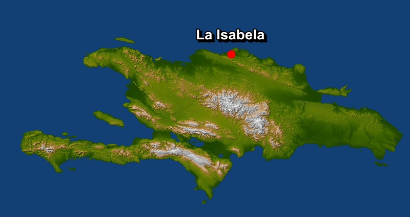
Columbus returned to the Caribbean in 1493 with seventeen ships and about 1,200 settlers to found a colony. He sighted Dominica, Guadeloupe and Puerto Rico, found the La Navidad garrison dead, and founded La Isabela on Hispaniola before exploring Jamaica and the south coast of Cuba, which he insisted was part of Asia.
Atlantic
 14977,471 km
John Cabot’s Voyage to North America
In 1497 the Venetian navigator John Cabot sailed from Bristol in the small ship Matthew under a patent from Henry VII. He reached a "new found land", probably Newfoundland or Cape Breton, on 24 June, went ashore once, and returned to England in August to a hero’s welcome. He vanished on a second voyage the next year.
Atlantic
 1497–149942,065 km
Vasco da Gama’s Voyage to India
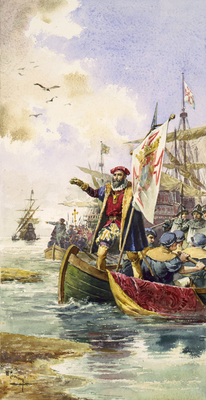
Vasco da Gama left Lisbon in July 1497 and swung far out into the South Atlantic, more than three months out of sight of land, before rounding the Cape of Good Hope. With a pilot taken on at Malindi he crossed the Arabian Sea to Calicut in May 1498, opening the first sea route from Europe to Asia. Scurvy killed more than half his men on the way home.
Atlantic · Indian Ocean
 1498–150015,466 km
Third Voyage of Christopher Columbus
On his third voyage Columbus took a southern course through the Cape Verde Islands, sighted Trinidad and landed on the Paria Peninsula of Venezuela, the first time Europeans set foot on the South American mainland. Back on Hispaniola he faced a colony in revolt, and in 1500 the royal inspector Francisco de Bobadilla shipped him to Spain in chains.
Atlantic
 1500–150140,610 km
Cabral’s Armada to India and Brazil
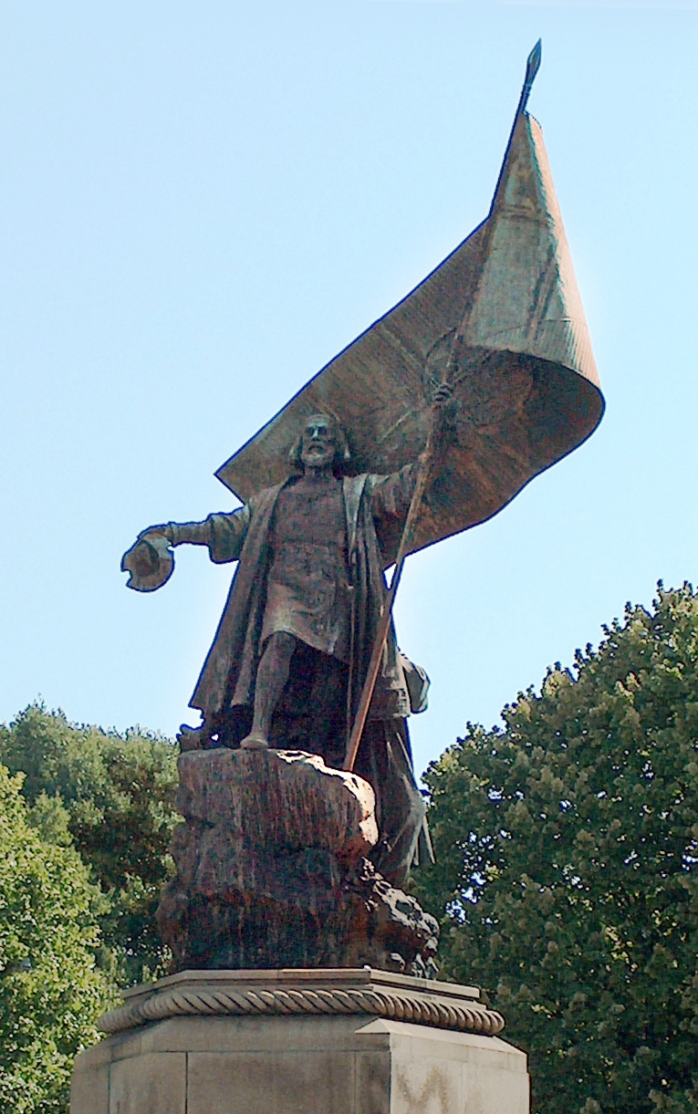
The second Portuguese fleet to India, thirteen ships under Pedro Álvares Cabral, swung so far west in the Atlantic that it reached the coast of Brazil in April 1500 and claimed it for Portugal. Four ships, one commanded by Bartolomeu Dias, were lost in a storm in the South Atlantic. In India a massacre at the Calicut trading post led Cabral to bombard the city and move the trade to Cochin.
Atlantic · Indian Ocean
 1502–150419,150 km
Fourth Voyage of Christopher Columbus
Columbus’s last voyage set out in 1502 to find a strait to the Indian Ocean. He charted the Caribbean coast of Central America from Honduras to Panama and tried to found a gold-mining post at Belén, but shipworm destroyed his fleet and he spent a year marooned on Jamaica before rescue.
Atlantic
 1519–152257,422 km
Magellan–Elcano Expedition
Five Spanish ships under Ferdinand Magellan set out in 1519 to reach the Spice Islands by sailing west. They found the strait at the tip of South America, crossed the Pacific in 98 days of starvation and reached the Philippines, where Magellan was killed. Three years after leaving, one ship, the Victoria, came home under Juan Sebastián Elcano with 18 men, completing the first voyage around the world.
Atlantic · Pacific · Indian Ocean
 15349,898 km
Jacques Cartier’s First Voyage
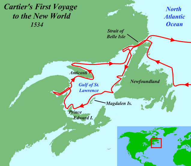
In 1534 Francis I sent the Breton pilot Jacques Cartier to look for a passage to Asia and for gold. In twenty days Cartier crossed to Newfoundland, passed through the Strait of Belle Isle and charted much of the Gulf of St. Lawrence. At Gaspé he raised a cross claiming the land for France and took two sons of the Iroquoian chief Donnacona back to France.
Atlantic
 1577–158065,082 km
Francis Drake’s Circumnavigation
Francis Drake left Plymouth in 1577 on a voyage secretly backed by Elizabeth I to raid Spain’s Pacific colonies. Only his own ship, renamed the Golden Hind, came through the Strait of Magellan. He plundered the coasts of Chile and Peru, careened on the coast of California, crossed the Pacific and Indian Oceans, and reached England in 1580 with treasure that repaid his investors many times over.
Atlantic · Pacific · Indian Ocean
 1595–159746,345 km
First Dutch Expedition to the East Indies
Four Dutch ships under Cornelis de Houtman left Texel in 1595 using Portuguese sailing directions smuggled out of Lisbon. The expedition was a catalogue of quarrels, scurvy and violence, and only 87 of 249 men came home, but it reached Banten on Java and returned with pepper. Within seven years the Dutch East India Company was founded.
Atlantic · Indian Ocean
 160916,197 km
Henry Hudson’s Voyage on the Halve Maen
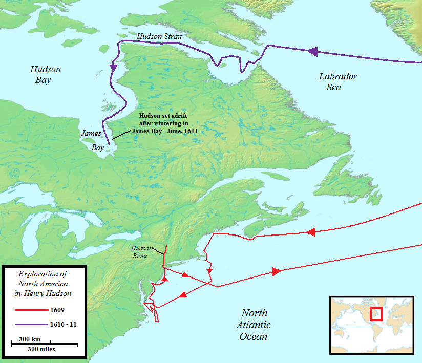
Sent by the Dutch East India Company to find a north-east passage to Asia, the Englishman Henry Hudson turned back from the ice off Norway and, against his orders, crossed the Atlantic instead. He sailed along the American coast and up the river that bears his name almost to present-day Albany, giving the Dutch their claim to New Netherland.
Arctic · Atlantic
 162011,207 km
Voyage of the Mayflower
In September 1620 the merchant ship Mayflower left Plymouth, England, with 102 passengers, many of them Puritan separatists who had lived in exile in the Netherlands. After 66 days at sea they sighted Cape Cod, signed the Mayflower Compact in Provincetown Harbor, and in December settled at Plymouth, where half of them died in the first winter.
Atlantic
 1642–164328,792 km
Abel Tasman’s Voyage to Tasmania and New Zealand
In 1642 the Dutch East India Company sent Abel Tasman from Batavia to explore the unknown southern ocean. Sailing far south, he became the first European to reach Tasmania and New Zealand, where a clash with Māori in Golden Bay cost four of his men. He returned by Tonga, Fiji and New Guinea, having sailed right around Australia without seeing it.
Indian Ocean · Southern Ocean · Pacific
 1733–174319,196 km
Bering and the Great Northern Expedition
The Great Northern Expedition was one of the largest scientific enterprises of the eighteenth century, mapping the whole Arctic coast of Siberia. Its climax was Vitus Bering’s 1741 voyage from Kamchatka: the St. Peter and the St. Paul reached Alaska, but on the way back the St. Peter was wrecked on an island where Bering and much of his crew died of scurvy.
Pacific · Arctic
18th Century (9)
![[Illustrations de A Voyage round the world in the years MDCCXL, I, II, II, IV. By George Anson. Compiled... by Richard Walter] / J. Mason, grav. ; Richard Walter, aut. du texte Éditeur : J. and P. Knapton (london) 1748](https://upload.wikimedia.org/wikipedia/commons/4/46/Anson-Mason-1748-06.jpg) 1740–174467,100 km
1740–174467,100 kmAnson’s Voyage Around the World
In 1740, during the War of Jenkins’ Ear, Commodore George Anson led six warships to attack Spain’s Pacific empire. A terrible passage round Cape Horn and an epidemic of scurvy destroyed most of the squadron, but Anson’s flagship Centurion went on to cross the Pacific and capture the Manila galleon off the Philippines. He came home in 1744 a national hero with one ship and a fortune in silver.
Atlantic · Pacific · Indian Ocean
 1766–176963,544 km
Bougainville’s Circumnavigation
Louis Antoine de Bougainville, a soldier turned sailor, led the first French voyage around the world. After handing the Falkland Islands to Spain he crossed the Pacific by Tahiti, which his account turned into a European dream of paradise, and was turned back by the Great Barrier Reef. On board the Étoile, the botanist’s assistant Jeanne Baret was discovered to be a woman.
Atlantic · Pacific · Indian Ocean
 1768–177159,590 km
First Voyage of James Cook
The Endeavour sailed in 1768 to observe the transit of Venus from Tahiti, with secret orders to search for a southern continent. James Cook went on to chart the whole coast of New Zealand and reached the unknown east coast of Australia, landing at Botany Bay and nearly losing the ship on the Great Barrier Reef. Disease at Batavia killed a third of the crew before the voyage ended in 1771.
Atlantic · Pacific · Indian Ocean
 1772–177582,304 km
Second Voyage of James Cook
On his second voyage Cook set out to settle whether a great southern continent existed. Sailing the Resolution in wide sweeps of the Southern Ocean, he crossed the Antarctic Circle three times and reached 71°10′S without sighting Antarctica. Between sweeps he wintered in the tropical Pacific. The voyage also proved John Harrison’s marine chronometer, which made longitude at sea practical.
Atlantic · Southern Ocean · Pacific · Indian Ocean
 1776–178090,384 km
Third Voyage of James Cook
Cook’s last voyage went to find the North-West Passage from the Pacific side. On the way he became the first European to reach Hawaii, then charted the coast of North America from Oregon to the Bering Strait until ice stopped him. Returning to Hawaii, he was killed at Kealakekua Bay in February 1779. The ships made a second attempt on the Arctic before coming home in 1780.
Atlantic · Indian Ocean · Pacific · Arctic
 1785–178867,966 km
Lapérouse Expedition
Louis XVI sent Lapérouse round the world in 1785 to complete Cook’s work. His two ships surveyed Alaska, California, the coasts of Japan, Korea and Tartary and the strait that now bears his name, sending journals home overland from Kamchatka and from Botany Bay. After leaving Australia in March 1788 they vanished; decades later their wrecks were found on the reefs of Vanikoro.
Atlantic · Pacific
 1787–178827,599 km
The First Fleet to Australia
Eleven ships left Portsmouth in May 1787 carrying about 1,400 people, more than half of them convicts, to found a penal colony in New South Wales. After eight months and 24,000 km via Tenerife, Rio de Janeiro and Cape Town, Arthur Phillip found Botany Bay unsuitable and moved to Port Jackson, where the British flag was raised at Sydney Cove on 26 January 1788.
Atlantic · Indian Ocean · Southern Ocean
 1787–179052,886 km
HMS Bounty and Bligh’s Open-Boat Voyage
The Bounty sailed in 1787 to carry breadfruit plants from Tahiti to the West Indies. Three weeks after leaving Tahiti, Fletcher Christian and part of the crew seized the ship and set William Bligh and eighteen loyal men adrift in a 7-metre launch. Bligh navigated it 6,700 km to Timor in 47 days; the mutineers ended up on remote Pitcairn Island, where they burned the ship.
Atlantic · Indian Ocean · Pacific
 1791–179584,741 km
Vancouver Expedition
George Vancouver, who had sailed with Cook, spent four and a half years surveying the Pacific coast of North America from California to Alaska in small boats, inlet by inlet. His charts proved there was no navigable passage to the Atlantic and named Puget Sound, Mount Rainier and Vancouver Island. Between seasons he wintered in Hawaii.
Atlantic · Indian Ocean · Pacific
19th Century (9)
 1831–183668,256 km
Second Voyage of HMS Beagle
HMS Beagle left Plymouth in 1831 for a five-year survey of the coasts of South America, with the 22-year-old Charles Darwin aboard as a gentleman naturalist. While FitzRoy charted Patagonia and Tierra del Fuego, Darwin rode inland collecting fossils, rocks and animals. Five weeks in the Galápagos and the long voyage home round the world gave him the material for On the Origin of Species.
Atlantic · Pacific · Indian Ocean
 1839–184210,002 km
La Amistad Revolt and Voyage
In 1839, 53 Mende people illegally enslaved in Sierra Leone were being shipped along the Cuban coast on the schooner La Amistad when they rose up, killing the captain and cook. They ordered the two surviving Spaniards to sail for Africa, but the Spaniards steered north by night, and after two months the ship was seized off Long Island. The case reached the US Supreme Court, which freed the captives in 1841.
Atlantic
 1845–18487,345 km
Franklin’s Lost Expedition
In 1845 the Admiralty sent two of its best-equipped ships under Sir John Franklin to force the North-West Passage. They were last seen by whalers in Baffin Bay that July. Searches over the next decades, and Inuit testimony, pieced together what happened: the ships were trapped in ice off King William Island, Franklin died in 1847, and the crews died trying to walk south. Parks Canada found Erebus in 2014 and Terror in 2016.
Atlantic · Arctic
 186626,122 km
Great Tea Race of 1866
In May 1866 sixteen clipper ships left Fuzhou racing to bring the new season’s tea to London, where the first cargo earned a premium. After 99 days and some 26,000 km round the Cape of Good Hope, Ariel and Taeping came up the English Channel side by side, and Taeping docked first by about twenty minutes, with Serica on the same tide. The race was close to the end of the age of sail: the Suez Canal opened in 1869.
Pacific · Indian Ocean · Atlantic
 1872–187698,105 km
Challenger Expedition
HMS Challenger, a warship with most of her guns removed and laboratories fitted, sailed 127,000 km in three and a half years to study the deep ocean. Her scientists sounded the depth, measured temperatures and dredged the sea floor at 362 stations, discovering thousands of new species and the deepest point on Earth in the Mariana Trench. The results filled 50 volumes and founded the science of oceanography.
Atlantic · Southern Ocean · Indian Ocean · Pacific
 1878–188036,735 km
Vega Expedition Through the Northeast Passage
The Swedish-Finnish scientist Adolf Erik Nordenskiöld sailed the steam whaler Vega along the whole Arctic coast of Siberia in 1878, the first ship to make the Northeast Passage. Frozen in only a short way from the Bering Strait, the expedition wintered among the Chukchi, then sailed on to Japan and home through the Suez Canal, the first voyage around Europe and Asia.
Atlantic · Arctic · Pacific · Indian Ocean · Mediterranean
 1879–18818,509 km
Jeannette Expedition
In 1879 the USS Jeannette sailed through the Bering Strait hoping to reach the North Pole by a warm current that did not exist. Frozen into the pack, she drifted for 21 months until the ice crushed her north of Siberia. The crew dragged their boats across the ice to the New Siberian Islands and set out for the Lena delta; De Long and most of his party starved there. Wreckage from the ship drifting ashore in Greenland three years later gave Fridtjof Nansen the idea for the Fram.
Pacific · Arctic
 1893–189613,501 km
Nansen’s Fram Expedition
Fridtjof Nansen built the Fram with a rounded hull that the ice would squeeze upward rather than crush, and let her freeze into the pack north of Siberia in 1893 to drift across the Arctic Ocean. When the drift missed the pole, Nansen and Hjalmar Johansen left the ship with skis, sledges and kayaks and reached a record 86°14′N before retreating to Franz Josef Land. The Fram came out of the ice near Svalbard in 1896 with every man alive.
Atlantic · Arctic
 1895–189866,190 km
Joshua Slocum’s Solo Voyage on the Spray
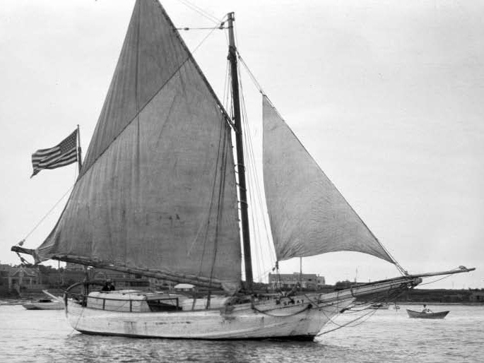
In 1895 the Nova Scotia-born sea captain Joshua Slocum set out from Boston alone in the Spray, an old oyster sloop he had rebuilt himself. Over three years and 74,000 km he crossed the Atlantic twice, fought through the Strait of Magellan, and sailed across the Pacific and Indian Oceans, becoming the first person to sail around the world alone. His book Sailing Alone Around the World is still in print.
Atlantic · Pacific · Indian Ocean
20th Century (12)
 1903–190615,159 km
Amundsen’s Gjøa Through the Northwest Passage
Roald Amundsen bought the small herring boat Gjøa and in 1903 slipped out of Christiania at night to escape his creditors. He spent two winters at a harbour on King William Island, now Gjoa Haven, learning from the Netsilik Inuit how to travel and dress in the Arctic, then threaded the shallow channels westward. After a third winter on the Yukon coast he reached Nome in August 1906, the first to sail the North-West Passage.
Atlantic · Arctic · Pacific
 1907–190976,471 km
Great White Fleet World Cruise
President Theodore Roosevelt sent sixteen battleships, their hulls painted white, round the world between 1907 and 1909 to show the United States was a naval power. The fleet steamed 69,000 km round South America and across the Pacific to Australia, the Philippines and Japan, then home through the Suez Canal, coaling at 20 ports and stopping to help after the Messina earthquake.
Atlantic · Pacific · Indian Ocean · Mediterranean
 19126,180 km
RMS Titanic’s Maiden Voyage
The largest ship afloat, the Titanic left Southampton on her maiden voyage to New York on 10 April 1912, calling at Cherbourg and Queenstown. Four days later, at 11:40 p.m., she struck an iceberg south of the Grand Banks and sank in two hours and forty minutes. There were lifeboats for barely half of the 2,224 on board; about 1,500 died, and the Carpathia brought 710 survivors to New York.
Atlantic
 1914–191725,641 km
Shackleton’s Endurance Expedition
Shackleton set out in 1914 to cross Antarctica on foot, but the Endurance was trapped in the pack ice of the Weddell Sea before reaching land and crushed ten months later. The 28 men camped on the drifting ice, then took to three boats and reached desolate Elephant Island. Shackleton and five others sailed the 7-metre James Caird 1,300 km to South Georgia, crossed its glaciers on foot, and after four attempts rescued everyone left behind. The wreck was found in 2022, 3,008 m down.
Atlantic · Southern Ocean
 19155,296 km
RMS Lusitania’s Last Voyage
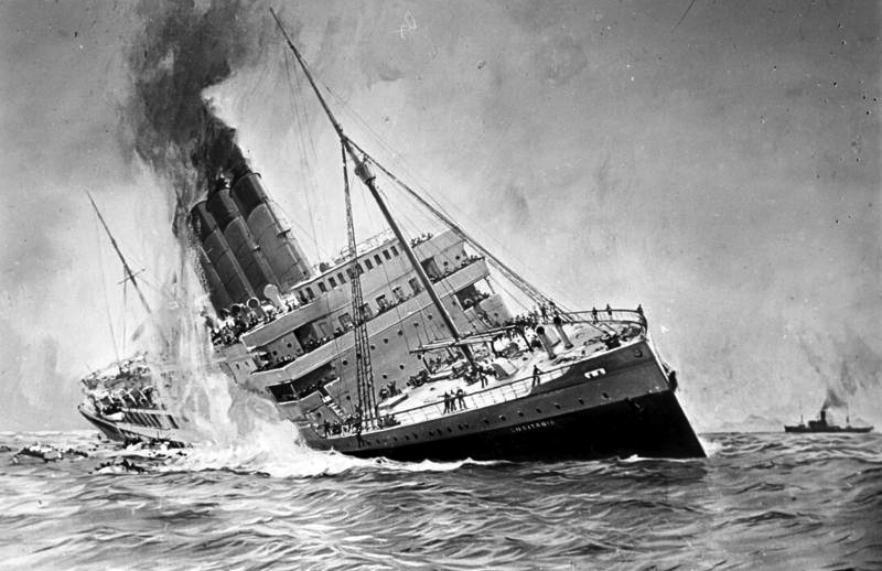
On 1 May 1915 the Cunard liner Lusitania left New York for Liverpool despite German warnings that ships in British waters were liable to be sunk. Six days later, eleven miles off the Old Head of Kinsale, the submarine U-20 hit her with a single torpedo and she sank in eighteen minutes. Of 1,960 people on board, 1,197 died, including 128 Americans, and the sinking helped turn the United States against Germany.
Atlantic
 193916,464 km
Voyage of the MS St. Louis
In May 1939 the German liner St. Louis left Hamburg with 937 passengers, almost all Jews fleeing Nazi persecution with landing permits for Cuba. Cuba refused to honour the permits, and the United States and Canada also turned the ship away while she lingered off Miami. Captain Gustav Schröder refused to return to Germany; the refugees were taken in by Britain, France, Belgium and the Netherlands, but 254 of them later died in the Holocaust.
Atlantic
 19419,645 km
Bismarck’s Last Sortie (Operation Rheinübung)
In May 1941 the new battleship Bismarck and the cruiser Prinz Eugen broke out into the Atlantic to attack Allied convoys. In the Denmark Strait they sank HMS Hood, pride of the Royal Navy, with all but three of her 1,418 men. The Royal Navy hunted the Bismarck for three days until a Swordfish torpedo bomber from the Ark Royal jammed her rudder, and on 27 May battleships pounded her until she sank.
Atlantic
 19478,172 km
Kon-Tiki Expedition
In 1947 the Norwegian Thor Heyerdahl set out to show that South Americans could have settled Polynesia by building a raft of balsa logs on the pattern of old Peruvian rafts. Carried by the Humboldt Current and the trade winds, the Kon-Tiki drifted 6,900 km across the Pacific in 101 days before breaking up on the reef of Raroia. DNA studies show Polynesians came from Asia, though some early contact with South America did occur.
Pacific
 194813,606 km
HMT Empire Windrush Voyage to Britain
In 1948 the troopship Empire Windrush, returning from Australia, called at Trinidad, Jamaica, Mexico, Cuba and Bermuda and picked up hundreds of Caribbean men and women answering Britain’s call for workers. She docked at Tilbury on 21 June with 802 passengers from the Caribbean. Their arrival became the symbol of the "Windrush generation" who helped rebuild post-war Britain.
Atlantic
 195813,269 km
USS Nautilus Under the North Pole (Operation Sunshine)
In August 1958 the world’s first nuclear-powered submarine, USS Nautilus, crossed the Arctic Ocean beneath the ice from the Pacific to the Atlantic. Leaving Pearl Harbor in secret, she dived near Point Barrow and at 11:15 p.m. on 3 August passed under the North Pole, the first vessel ever to reach it, before surfacing in the Greenland Sea 96 hours later.
Pacific · Arctic · Atlantic
 1968–196947,294 km
Knox-Johnston and Suhaili in the Golden Globe Race
In 1968 the Sunday Times offered a trophy for the first person to sail alone around the world without stopping. Nine men started; Robin Knox-Johnston, a merchant navy officer, sailed his small teak ketch Suhaili out of Falmouth on 14 June and was the only one to finish, returning 312 days later on 22 April 1969. Bernard Moitessier chose to sail on to Tahiti, and Donald Crowhurst faked his voyage and was lost at sea.
Atlantic · Indian Ocean · Southern Ocean · Pacific
 19764,463 km
Hōkūleʻa’s Voyage to Tahiti
In 1976 the Hōkūleʻa, a replica of an ancient Hawaiian double-hulled canoe, sailed 4,400 km from Maui to Tahiti with no compass, charts or instruments. The Micronesian master navigator Mau Piailug steered by the stars, swells and birds, and 33 days later the crew sighted Mataiva in the Tuamotus. Seventeen thousand people met them at Papeete, and the voyage proved that Polynesians could have settled the Pacific deliberately.
Pacific
How these maps are made
The stops of each voyage are taken by hand from its Wikipedia article, from published journals that are now in the public domain, and from Wikidata. YearMaps then draws the line between them at sea, around Natural Earth coastlines, opening the Suez and Panama canals only after they were built. Stretches where the position or track is uncertain are dashed.
Text: Wikipedia (CC BY-SA 4.0). Facts: Wikidata (CC0). Images: Wikimedia Commons, public domain or CC BY / CC BY-SA, credited on each page. Land: Natural Earth (public domain).