
Henry Hudson’s Voyage on the Halve Maen (1609)
Sent by the Dutch East India Company to find a north-east passage to Asia, the Englishman Henry Hudson turned back from the ice off Norway and, against his orders, crossed the Atlantic instead. He sailed along the American coast and up the river that bears his name almost to present-day Albany, giving the Dutch their claim to New Netherland.
16,197 km mapped11 stops215 days (about 7 months)
Route Map of Hudson’s 1609 voyage
- Route from recorded positions
- Reconstructed or uncertain track
- Over ice, overland or up a river
- 1Numbered stop (see the itinerary)
- Ship on the map: carrack with castles fore and aft (Age of Discovery)
Lines are drawn by YearMaps between the recorded stops, kept at sea around Natural Earth coastlines. They show the order and general track of the voyage, not the exact course steered. How the maps are made.
About Hudson’s 1609 voyage
Henry Hudson (c. 1565 – disappeared 23 June 1611) was an English sea explorer and navigator during the early 17th century, best known for his explorations of present-day Canada and parts of the Northeastern United States.
In 1607 and 1608, Hudson made two attempts on behalf of English merchants to find a rumoured Northeast Passage to Cathay via a route above the Arctic Circle. In 1609, he landed in North America on behalf of the Dutch East India Company and explored the region around the modern New York metropolitan area. Looking for a Northwest Passage to Asia on his ship Halve Maen ("Half Moon"), he sailed up the Mahicannittuk (Mohican), (a.k.a., Ka'nón:no [Mohawk] and Muhheakantuck [Lenape]), later named the Hudson River, and thereby laid the foundation for Dutch colonization of the region. His contributions to the exploration of the New World were significant and lasting. His voyages helped to establish European contact with the native peoples of North America and contributed to the development of trade and commerce.
From Wikipedia: Henry Hudson (CC BY-SA 4.0).
Itinerary: 11 Stops
In order of the voyage. Numbers match the map; select a stop to show it there.
Texel
DepartureThe Halve Maen sails for the north-east passage.
Off the North Cape
EventIce and a near-mutiny by the cold crew make Hudson turn back.
Faroe Islands
Port of callHudson heads west across the Atlantic, against his contract.
Penobscot Bay, Maine
Port of callThe crew cuts a new foremast and raids a Native village.
Cape Cod
PassageHudson sails south along the coast.
Mouth of Chesapeake Bay
PassageHudson turns north short of the English colony at Jamestown.
Delaware Bay
PassageShoals stop him from entering.
New York Bay
LandfallThe Halve Maen anchors inside Sandy Hook. John Colman is killed by an arrow on 6 September.
Near Albany
ArrivalAbout 240 km up the river the water grows too shallow. Hudson trades with the Mohicans.
By river.
New York Bay
Port of callHudson leaves for Europe.
By river.
Dartmouth, England
ArrivalThe English authorities detain Hudson and forbid him to sail for the Dutch again.
Sources: Robert Juet’s journal, via Wikipedia: Henry Hudson.
Henry Hudson’s Voyage on the Halve Maen in Depth
Expedition of 1609
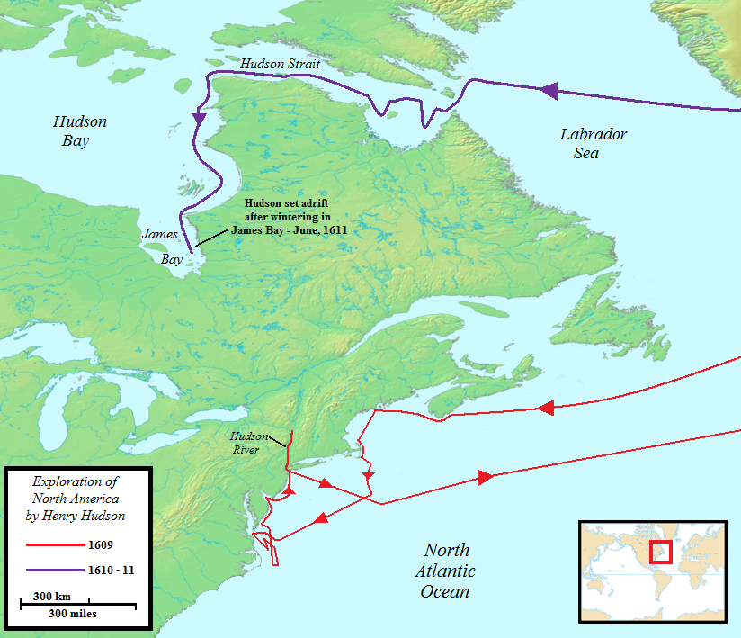
In 1609, Hudson was chosen by merchants of the Dutch East India Company in the Netherlands to find an easterly passage to Asia. While awaiting orders and supplies in Amsterdam, he heard rumours of a northwest route to the Pacific through North America. Hudson had been told to sail through the Arctic Ocean north of Russia, into the Pacific and so to the Far East. Hudson departed Amsterdam on 4 April, in command of the Dutch ship Halve Maen (English: Half Moon). He could not complete the specified (eastward) route because ice blocked the passage, as with all previous such voyages, and he turned the ship around in mid-May while somewhere east of Norway's North Cape. At that point, acting outside his instructions, Hudson pointed the ship west and decided to try to seek a westerly passage through North America.
They reached the Grand Banks of Newfoundland on 2 July, and in mid-July made landfall near the LaHave area of Nova Scotia. Here they encountered Indigenous people who were accustomed to trading with the French; they were willing to trade beaver pelts, but apparently no trades occurred. The ship stayed in the area about ten days, the crew replacing a broken mast and fishing for food. On the 25 July, a dozen men from Halve Maen, using muskets and small cannon, went ashore and assaulted the village near their anchorage. They drove the people from the settlement and took their boat and other property—probably pelts and trade goods.
On 4 August, the ship was at Cape Cod, from which Hudson sailed south to the entrance of the Chesapeake Bay. Rather than entering the Chesapeake he explored the coast to the north, finding Delaware Bay but continuing on north. On 3 September, he reached the estuary of the river that initially was called the "North River" or "Mauritius" and now carries his name. He was not the first European to discover the estuary, though, as it had been known since the voyage of Giovanni da Verrazzano in 1524.
On 6 September 1609, John Colman of his crew was killed by natives with an arrow to his neck. Hudson sailed into the Upper New York Bay on 11 September, and the following day encountered a large group of 28 Lenape canoes occupied by Lenape Natives, from whom he bought oysters and beans. He then began a journey up what is now known as the Hudson River. Over the next ten days his ship ascended the river, reaching a point near Stuyvesant Landing (Old Kinderhook). There the ship's boat with five crew members ventured to the vicinity of present-day Albany.
On 23 September, Hudson decided to return to Europe. On his way back to Holland, he put in at Dartmouth, England on 7 November, and was detained by authorities who wanted access to his log. He passed the log to the Dutch ambassador to England, who sent it, along with his report, to Amsterdam.
While exploring the Hudson River, Hudson had traded with several native groups, mainly obtaining furs. His voyage established Dutch claims to the region and to the fur trade that prospered there when a trading post was established at Albany in 1614. New Amsterdam on Manhattan Island became the capital of New Netherland in 1625.
Sections adapted from Wikipedia: Henry Hudson (CC BY-SA 4.0).
Pictures of Hudson’s 1609 voyage
23 images from Wikimedia Commons. Select one to enlarge it.
Front view of a replica of Henry Hudson's ship Halve Maen (Half Moon)Unknown authorUnknown author · Public domain · Commons Landing of Henry Hudson, 1609, at Verplanck Point, New York oil on canvas 83.8 x 121.9 cm signed b.c.: Rbt W Weir 1835Robert Walter Weir · Public domain · Commons Drawing of Henry Hudson's ship, the Half Moon.Unknown authorUnknown author · Public domain · Commons Hudson river from bear mountain bridgeUnknown author · CC BY-SA 3.0 · Commons Map of the Hudson River drainage basin, made using USGS National Map data.Shannon1 · CC BY-SA 4.0 · Commons The 2005 replica of the Dutch sailing ship Halve Maen, docked at the Corning Preserve on the Hudson River in Albany, New YorkThis image or media was taken or created by Matt H. Wade. To see his entire portfolio, click here. · CC BY-SA 3.0 · Commons Henry Hudson's Half Moon sailing ship.Original uploader was Nonenmac at en.wikipedia · Public domain · Commons Henry Hudson's Halve Maen.Stereo Travel Co. · Public domain · Commons 2016 One World Observatory view along Hudson RiverBeyond My Ken · CC BY-SA 4.0 · Commons Bird's-eye view of the Hudson River, New York, USA, from the Walkway Over the Hudson, a footbridge that spans the river.Juliancolton · Public domain · Commons Bird on the east side bank of the Hudson river.Photograph by Mike Peel (www.mikepeel.net). · CC BY-SA 4.0 · Commons anthonyquintano.comAnthony Quintano from Hillsborough, NJ, United States · CC BY 2.0 · Commons Sunny Morning on the Hudson RiverThomas Cole · Public domain · Commons A scene along the Hudson River just above New YorkGeorge Bellows · Public domain · Commons The George Washington Bridge over the Hudson River in New YorkJohn O'Connell · CC BY 2.0 · Commons The Hudson and East Rivers in NYC.Quasipalm · CC BY-SA 2.5 · Commons DEBRIS FLOATING ON THE HUDSON RIVER NEAR THE NEWLY CONSTRUCTED WORLD TRADE CENTER May 1973 Changed contrast and color of original image for a more accurate representation.Wil Blanche · Public domain · Commons The Hudson River flowing out of Henderson Lake in Tahawus, New York.Adam Moss · CC BY-SA 2.0 · Commons Amsterdam New York west of Albany, an old mill town once known for carpets and cabbage patch dolls and Kirk Douglasbobistraveling · CC BY 2.0 · Commons Norrie Point Environmental Center at Norrie Point in Hyde Park, NY.Ɱ · CC BY-SA 4.0 · Commons Marty Plante canoeing the rapids on the Hudson River Gorge.MJPlante1 · CC BY-SA 4.0 · Commons A view of the Riparius Bridge over the Hudson River as viewed from the south on the eastern shore.ProfessorKouk · Public domain · Commons Statue of Liberty National Monument STLI2258National Park Service Digital Image Archives · Public domain · Commons
Frequently Asked Questions
How long did Hudson’s 1609 voyage take?
It lasted 215 days (about 7 months), from 6 April 1609 to 7 November 1609.
How far did Hudson’s 1609 voyage travel?
The route as mapped here, through all 11 stops, is about 16,197 km (8,746 nautical miles). It follows the recorded stops at sea and is a reconstruction, so the true distance sailed was longer.
Who led Hudson’s 1609 voyage?
Henry Hudson, sponsored by Dutch East India Company (VOC).
What ship was used on Hudson’s 1609 voyage?
Halve Maen (Half Moon).
Where did Hudson’s 1609 voyage start and end?
It started at Texel (6 April 1609) and ended at Dartmouth, England (7 November 1609).
What did Hudson’s 1609 voyage achieve?
Exploration of the Hudson River and the Dutch claim that became New Netherland.