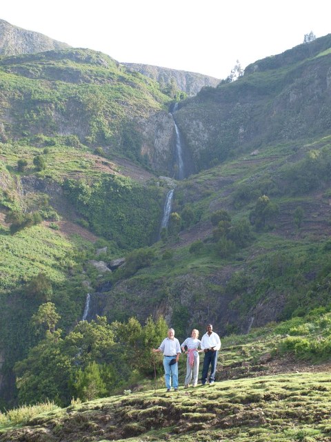
Ethiopian Highlands
Range/mtn · 638,304 km²
Ethiopian Highlands is a range/mtn in Africa, covering an estimated 638,304 km². It extends across Ethiopia and Eritrea. It is the 4th-largest of the 216 mountain ranges with a mapped extent in YearMaps.
The Ethiopian Highlands, also known as the Abyssinian Highlands, is a rugged mass of mountains extending from Ethiopia to Eritrea in Northeast Africa. It forms the largest continuous area of its elevation in the continent, with little of its surface falling below 1,500 m (4,900 ft), while the summits reach heights of up to 4,550 m (14,930 ft). It is sometimes called the "Roof of Africa" due to its height and large area. Ethiopia is the only country in the region with such a high elevated surface. This elevated surface is bisected diagonally by the Great East African Rift System which extends from Syria to Mozambique across the East African Great Lakes. Most of the Ethiopian Highlands are part of central and northern Ethiopia, with the Eritrean Highlands as its northernmost portion. The Ethiopia-Yemen Continental Flood Basalts are shared between the Horn of Africa and highlands of Upper Yemen along with the cultural, historical, and genetic ties of the two regions on opposite sides of the Red Sea.
Adapted from Wikipedia: Ethiopian Highlands (CC BY-SA 4.0).
- Feature class
- Range/mtn
- Mapped extent
- 638,304 km²
- Size rank
- #4 of 216 mountain ranges
- Region
- Africa
- Countries
- Ethiopia, Eritrea
- Coordinates
- 9.3181°, 37.3081°
- Summits:
- Gugu (3,626 m), Mount Batu (4,307 m), Ras Dejen (4,533 m)
- Adjacent ranges:
- Ahmar Mountains (Africa), Ogo Mountains (Africa)
- Settlements:
- Hagere Hiywet (38 km), Addis Ababa (79 km), Giyon (83 km)
More about Ethiopian Highlands
Physical geography
The Highlands are divided into northwestern and southeastern portions by the Main Ethiopian Rift, which contains a number of salt lakes. The northwestern portion, known as the Abyssinian Massif, includes the Semien Mountains, part of which has been designated the Simien Mountains National Park. Its summit, Ras Dashen (4,550 m), is the highest peak in Ethiopia. Lake Tana, the source of the Blue Nile, also lies in the northwestern portion of the Ethiopian Highlands.
The southeastern portion is known as the Harar Massif. It's bounded in the west, by the fault line of the Rift Valley, in the east, by the Ogaden Lowlands and in the south, by the Elkerie and Borena Lowlands. Its highest peaks are located in the Bale Zone of Ethiopia's Oromia Region.
Geology
The Ethiopian Highlands began to rise 75 million years ago, as magma from the Earth's mantle uplifted a broad dome of the ancient rocks of the Arabian-Nubian Shield. The opening of the Great Rift Valley split the dome of the Ethiopian Highlands into three parts; the mountains of the southern Arabian Peninsula are geologically part of the ancient Ethiopian Highlands, separated by the rifting which created the Red Sea and Gulf of Aden and separated Africa from Arabia.
Around 30 million years ago, a flood basalt plateau began to form, piling layers upon layers of voluminous fissure-fed basaltic lava flows. Most of the flows were tholeiitic, save for a thin layer of alkali basalts and minor amounts of felsic (high-silica) volcanic rocks, such as rhyolite.
Climate
Spatial distribution of temperature in Ethiopia is determined primarily by altitude and latitude. Altitude is the main factor that determines the spatial distribution of temperature in Ethiopia. Ethiopia lies within the tropics, a zone of maximum insolation, where every place has overhead sun twice a year. However, considerable portions of Ethiopia are highland areas, and their altitudes give them non-tropical temperatures. Ethiopia's tropical climate occur in lowlands at the country's peripheries. The predominant climate of the Ethiopian Highlands is the Alpine climate.
Because the highlands elevate Ethiopia, located close to the equator, this has resulted in giving this country an unexpectedly temperate climate.
Ecology
The Ethiopian Highlands share a similar flora and fauna to other mountainous regions of Africa; this distinctive flora and fauna is known as Afromontane, but from the time of the last ice age the region has been populated with some Eurasian (palearctic) flora. The habitats are somewhat different on either side of the Great Rift Valley which splits the highlands.
At lower elevations, the highlands are surrounded by tropical savannas and grasslands, including the Sahelian acacia savanna to the northwest and the East Sudanian savanna to the west.
Sections adapted from Wikipedia: Ethiopian Highlands (CC BY-SA 4.0).
Ethiopian Highlands: Key Facts
| Highest point | Ras Dashen |
|---|
Facts from Wikidata Q319288 (CC0).