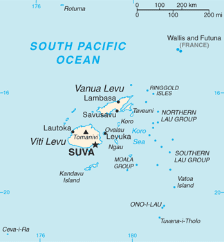
Viti Levu
Island group · 10,929 km²
Viti Levu is an island group in Oceania (Melanesia), covering an estimated 10,929 km².
Viti Levu (Fijian: [ˈβitʃi ˈleβu]; lit. 'Great Fiji') is the largest island in Fiji. It is the site of the country's capital and largest city, Suva, and home to a large majority of Fiji's population.
Adapted from Wikipedia: Viti Levu (CC BY-SA 4.0).
- Feature class
- Island group
- Mapped extent
- 10,929 km²
- Size rank
- #148 of 445 islands
- Region
- Oceania
- Subregion
- Melanesia
- Coordinates
- -17.8264°, 177.9813°
- Summits:
- Tomanivi (1,323 m), Mauga Silisili (1,858 m), Mount Tabwemasana (1,877 m)
- Ranges:
- Southern Alps (Oceania), Owen Stanley Range (Oceania)
More about Viti Levu
Geography, economy and ecology
Viti Levu is the largest island in the Republic of Fiji – home to 70% of the population (about 600,000 people) – and is the hub of the entire Fijian archipelago. It measures 146 kilometres (91 mi) long and 106 kilometres (66 mi) wide, and has an area of 10,389 square kilometres (4,011 sq mi). Earthquakes and volcanic eruptions account for the somewhat rugged terrain of the island, which is divided into roughly equal halves by a mountain range that runs north to south. The centre of the island is forested and includes the nation's highest peak Mount Tomanivi (otherwise known as Mount Victoria), which rises to 1,324 metres (4,344 ft).
The eastern side of the island experiences heavy rainfall, particularly in the mountains, and is home to Fiji's tropical moist forests.
History
Viti Levu is believed to have been inhabited longer than the island of Vanua Levu, which lies to its north. According to oral tradition, the first Melanesian settlers landed at Vuda Point and established Viseisei as Fiji's first oldest settlement. There is archaeological evidence contradicting this account.
Geology
Fiji lies in a tectonically complex area between the Australian plate and the Pacific plate. The Fiji Platform lies in a zone bordered by active extension fault lines, around which most of the shallow earthquakes in the area have been centred. These fault lines are: the Fiji Fracture Zone (FFZ) to the north; the 176° Extension Zone (176°E EZ) to the west; and the Hunter fracture zone (HFZ) and Lau Ridge to the east.
is made up of volcanic flows and volcaniclastics, which grade from basalt to trachyte and rhyolite. Geographically, this group is found south of Nadi, including on the peaks of Koromba (at 3528 feet high) and Natambumgguto (at 1242 feet high), and down to Sigatoka.
Sections adapted from Wikipedia: Viti Levu (CC BY-SA 4.0).
Viti Levu: Key Facts
| Area | 10,531 km² |
|---|---|
| Population | 580,000 |
| Highest point | Mount Tomanivi |
| Surrounded by | Pacific Ocean |
Facts from Wikidata Q208198 (CC0).