Skip to content
YearMaps
Iceland · Landforms

Mountain Ranges, Deserts and Landforms of Iceland

Vatnajökull is the largest of the 11 mountain ranges, deserts and other landforms recorded for Iceland, at 9,000 km², ahead of Vatnajökull at 8,492 km². The full list follows.

How this list is built: Ranked by mapped area. Covers mountain ranges, deserts, plateaus, named glaciers, plains, basins, peninsulas and capes. One that crosses a border is listed under every country it lies in, with the area of the whole feature. It covers the mountain ranges, deserts and other landforms indexed in YearMaps, drawn from open geospatial data, and is not an exhaustive national register.

Landforms Listed
11
Top Ranked
9,000 km²
Vatnajökull
Second
8,492 km²
Vatnajökull
Profiled Below
8
Photo, encyclopedia text and figures
Mountain Ranges, Deserts and Landforms of Iceland
#NameArea
1Vatnajökull9,000 km²
2Vatnajökull8,492 km²
3Langjökull1,092 km²
4Hofsjökull970 km²
5Mýrdalsjökull725 km²
6Drangajökull181 km²
7Eyjafjallajökull107 km²
8Tungnafellsjökull51 km²
9Myrkarjökull42 km²
10Irandarjökull27 km²
11Tindfjallajokull24 km²

The Landforms of Iceland in Detail

The 8 mountain ranges, deserts and other landforms above that have an encyclopedia article, in the same order, each with its photograph, figures and the places around it.

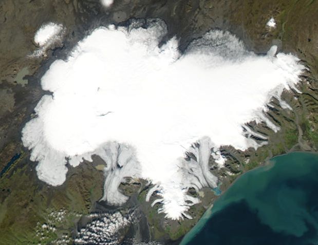
Vatnajökull
Image via Wikimedia Commons (author and licence on the file page).

Vatnajökull

Glaciated areas · 8,492 km²

Vatnajökull is a glaciated areas in Iceland, covering an estimated 8,492 km². It is the 13th-largest of the 68 glaciers and ice fields with a mapped extent in YearMaps.

Vatnajökull (Icelandic pronunciation: [ˈvahtnaˌjœːkʏtl̥] , literally "Glacier of Lakes"; sometimes translated as Vatna Glacier in English) is the largest and most voluminous ice cap in Iceland, and the second largest in area in Europe after the Severny Island ice cap of Novaya Zemlya. It is in the south-east of the island, covering approximately 8% of the country.

Adapted from Wikipedia: Vatnajökull (CC BY-SA 4.0).

Feature class
Glaciated areas
Mapped extent
8,492 km²
Size rank
#13 of 68 glaciers and ice fields
Coordinates
64.4722°, -17.1389°
Summits:
Slaettaratindur (882 m), Gunnbjørn Fjeld (3,694 m), Beerenberg (2,277 m)
Ranges:
Grampian Mountains (Europe), Cambrian Mountains (Europe)
Settlements:
Reykjavík (235 km), Inverness (1,041 km), Aberdeen (1,146 km)

View on the live map

More about Vatnajökull

Vatnajökull: Key Facts

Key facts about Vatnajökull
Length143 km
Area7,700 km²

Facts from Wikidata Q179734 (CC0).

Langjökull
Image via Wikimedia Commons (author and licence on the file page).

Langjökull

Glaciated areas · 1,092 km²

Langjökull is a glaciated areas in Iceland, covering an estimated 1,092 km².

Langjökull (Icelandic pronunciation: [ˈlauŋkˌjœːkʏtl̥] , Icelandic for "long glacier") is the second largest ice cap in Iceland (870 km2 (340 sq mi)), after Vatnajökull. It is situated in the west of the Icelandic interior or Highlands of Iceland and can be seen clearly from Haukadalur. It covers the higher parts of the Langjökull volcanic system.

Its volume is 195 km3 (47 cu mi) and the ice is up to 580 m (1,900 ft) thick. The highest point of the ice cap (at Baldjökull [ˈpaltˌjœːkʏtl̥] at the northern end of Langjökull) is about 1,450 m (4,760 ft) above sea level.

In the past, the largest recorded surface area was in 1840.

Adapted from Wikipedia: Langjökull (CC BY-SA 4.0).

Feature class
Glaciated areas
Mapped extent
1,092 km²
Size rank
#37 of 68 glaciers and ice fields
Coordinates
64.6311°, -20.1500°
Summits:
Gunnbjørn Fjeld (3,694 m), Slaettaratindur (882 m), Mount Forel (3,360 m)
Ranges:
Grampian Mountains (Europe), Cambrian Mountains (Europe)
Settlements:
Reykjavík (102 km), Inverness (1,164 km), Aberdeen (1,274 km)

View on the live map

More about Langjökull

Tourism

Langjökull attracts visitors who are captivated by its immense size and natural beauty. The glacier offers a unique experience for adventure enthusiasts and nature lovers alike. With its easily accessible location in the Icelandic interior, Langjökull provides opportunities for various activities, such as glacier hiking, snowmobiling, monster truck ride, and exploring natural ice caves and man-made tunnels. These experiences provide a different perspective of the glacier and its surroundings, enhancing the overall visit to Langjökull.

Located near popular tourist routes like the Golden Circle, Langjökull holds a prominent position in Iceland's tourism industry.

Sections adapted from Wikipedia: Langjökull (CC BY-SA 4.0).

Langjökull: Key Facts

Key facts about Langjökull
Area953 km²

Facts from Wikidata Q737657 (CC0).

Hofsjökull
Image via Wikimedia Commons (author and licence on the file page).

Hofsjökull

Glaciated areas · 970 km²

Hofsjökull is a glaciated areas in Iceland, covering an estimated 970 km².

Hofsjökull (Icelandic: "temple glacier", Icelandic pronunciation: [ˈhɔfsˌjœːkʏtl̥] ) is the third largest ice cap in Iceland after Vatnajökull and Langjökull and covers the largest active central volcano in the country, which has the same name. It is situated in the west of the Highlands of Iceland and north of the mountain range Kerlingarfjöll, between the two largest glaciers of Iceland.

Adapted from Wikipedia: Hofsjökull (CC BY-SA 4.0).

Feature class
Glaciated areas
Mapped extent
970 km²
Size rank
#40 of 68 glaciers and ice fields
Coordinates
64.8238°, -18.7803°
Summits:
Slaettaratindur (882 m), Gunnbjørn Fjeld (3,694 m), Beerenberg (2,277 m)
Ranges:
Grampian Mountains (Europe), Cambrian Mountains (Europe)
Settlements:
Reykjavík (169 km), Inverness (1,126 km), Aberdeen (1,232 km)

View on the live map

More about Hofsjökull

Hofsjökull: Key Facts

Key facts about Hofsjökull
Area925 km²

Facts from Wikidata Q554383 (CC0).

Mýrdalsjökull
Image via Wikimedia Commons (author and licence on the file page).

Mýrdalsjökull

Glaciated areas · 725 km²

Mýrdalsjökull is a glaciated areas in Iceland, covering an estimated 725 km².

Mýrdalsjökull (pronounced [ˈmirˌtalsˌjœːkʏtl̥] , Icelandic for "(the) mire dale glacier" or "(the) mire valley glacier") is an ice cap on the top of the Katla volcano in the south of Iceland. It is to the north of the town of Vík í Mýrdal and to the east of the smaller ice cap Eyjafjallajökull. Between these two glaciers is the Fimmvörðuháls pass.

The glacier contributes to the most serious natural hazard area of Iceland.

Adapted from Wikipedia: Mýrdalsjökull (CC BY-SA 4.0).

Feature class
Glaciated areas
Mapped extent
725 km²
Size rank
#44 of 68 glaciers and ice fields
Coordinates
63.6552°, -19.1030°
Summits:
Slaettaratindur (882 m), Gunnbjørn Fjeld (3,694 m), Mount Forel (3,360 m)
Ranges:
Grampian Mountains (Europe), Cambrian Mountains (Europe)
Settlements:
Reykjavík (150 km), Inverness (1,060 km), Londonderry (1,167 km)

View on the live map

More about Mýrdalsjökull

Glaciation History

The last glacial period came to an end 11,500 years ago and was followed by the Holocene. Mýrdalsjökull is likely to have been present throughout the Holocene and definitely the last 8400 years as there is no evidence of degassed erupted tephra from Katla. Jökulhlaup's 8000 to 6000 years ago took a path over the highest pass in the caldera wall which does not support a crater lake source but would happen with an ice cap.

Until the development of remote satellite imaging it was impossible to monitor to annual accuracy the mass balance of Mýrdalsjökull. Such techniques allowed it to be determined for Mýrdalsjökull that it is the summer temperatures that are the predominant driving factor in the recent recession of the glacier.

Sections adapted from Wikipedia: Mýrdalsjökull (CC BY-SA 4.0).

Mýrdalsjökull: Key Facts

Key facts about Mýrdalsjökull
Area596 km²

Facts from Wikidata Q214818 (CC0).

Drangajökull
Image via Wikimedia Commons (author and licence on the file page).

Drangajökull

Glaciated areas · 181 km²

Drangajökull is a glaciated areas in Iceland, covering an estimated 181 km².

Drangajökull (pronounced [ˈtrauŋkaˌjœːkʏtl̥] , regionally also [ˈtraŋk-]) is the northernmost glacier of Iceland, occupying the southern foothills of the Hornstrandir peninsula in the Westfjords region. It covers approximately 150 km2 and is the only Icelandic ice cap situated entirely below 1,000 metres in elevation. Lake sediment cores show that Drangajökull persisted near or above its present extent well into the mid-Holocene before retreating to near-modern limits between about 9,500 and 7,200 years ago. Modern airborne LiDAR mapping indicates the glacier has lost roughly 1.19 km3 of ice—an average thinning of 8.0 metres—since around 1990, even as its surge-type outlet glaciers periodically advance.

Adapted from Wikipedia: Drangajökull (CC BY-SA 4.0).

Feature class
Glaciated areas
Mapped extent
181 km²
Size rank
#55 of 68 glaciers and ice fields
Coordinates
66.1673°, -22.2489°
Summits:
Gunnbjørn Fjeld (3,694 m), Mount Forel (3,360 m), Beerenberg (2,277 m)
Ranges:
Grampian Mountains (Europe), Cambrian Mountains (Europe)
Settlements:
Reykjavík (225 km), Inverness (1,344 km), Ålesund (1,421 km)

View on the live map

More about Drangajökull

Holocene history

Sediment cores recovered from seven lakes around Drangajökull reveal how the ice cap behaved during the early and middle Holocene. These "threshold lakes" acted like natural switches: when the glacier margin reached them, meltwater carried fine mineral sediments into the lake basins; when the ice retreated, lakes filled instead with organic‐rich mud, or gyttja. By examining the layers of minerogenic sediment versus gyttja, and by dating terrestrial plant remains and well‐known volcanic ash (tephra) deposits such as the Saksunarvatn layer (10,200 years ago), researchers have charted the timing of glacier advances and retreats.

Sections adapted from Wikipedia: Drangajökull (CC BY-SA 4.0).

Drangajökull: Key Facts

Key facts about Drangajökull
Area160 km²

Facts from Wikidata Q555948 (CC0).

Eyjafjallajökull
Image via Wikimedia Commons (author and licence on the file page).

Eyjafjallajökull

Glaciated areas · 107 km²

Eyjafjallajökull is a glaciated areas in Iceland, covering an estimated 107 km².

Eyjafjallajökull (Icelandic: [ˈeiːjaˌfjatl̥aˌjœːkʏtl̥] ; "glacier of (the mountain) Eyjafjöll"), sometimes referred to by the numeronym E15, is one of the smaller ice caps of Iceland, north of Skógar and west of Mýrdalsjökull. The ice cap covers the caldera of a volcano with a summit elevation of 1,651 metres (5,417 ft). The volcano has erupted relatively frequently since the Last Glacial Period, most recently in 2010, when, although relatively small for a volcanic eruption, it caused enormous disruption to air travel across northern and western Europe for a week.

Adapted from Wikipedia: Eyjafjallajökull (CC BY-SA 4.0).

Feature class
Glaciated areas
Mapped extent
107 km²
Size rank
#60 of 68 glaciers and ice fields
Coordinates
63.6296°, -19.6085°
Summits:
Slaettaratindur (882 m), Gunnbjørn Fjeld (3,694 m), Mount Forel (3,360 m)
Ranges:
Grampian Mountains (Europe), Cambrian Mountains (Europe)
Settlements:
Reykjavík (128 km), Inverness (1,080 km), Londonderry (1,181 km)

View on the live map

More about Eyjafjallajökull

Geography

Eyjafjallajökull consists of a volcano completely covered by an ice cap. The retreating ice cap covered an area of 66 km2 (25 sq mi) in 2019, but was previously more than 80 square kilometres (30 square miles), with many outlet glaciers. The main outlet glaciers are to the north: Gígjökull, flowing into Lónið, and Steinsholtsjökull, flowing into Steinsholtslón. In 1967, there was a massive landslide on the Steinsholtsjökull glacial tongue. On 16 January 1967 at 13:47:55 there was an explosion on the glacier. It can be timed because the seismometers at Kirkjubæjarklaustur monitored the movement.

Geology

The stratovolcano, whose vents follow an east–west trend, is composed of basalt to andesite lavas. Most of its historical eruptions have been explosive. However, fissure vents occur on both (mainly the west) sides of the volcano. The volcano is 800,000 years old.

The volcano is fed by a magma chamber under the mountain, which in turn derives from the tectonic divergence of the Mid-Atlantic Ridge. It is part of a chain of volcanoes stretching across Iceland. Its nearest active neighbours are Katla, to the northeast, and Eldfell, on Heimaey, to the southwest.

The volcano is thought to be related to Katla geologically, in that eruptions of Eyjafjallajökull have generally been followed by eruptions of Katla.

Eyjafjallajökull erupted in the years 920, 1612, 1821, and 2010.

Sections adapted from Wikipedia: Eyjafjallajökull (CC BY-SA 4.0).

Eyjafjallajökull: Key Facts

Key facts about Eyjafjallajökull
Area78 km²

Facts from Wikidata Q39651 (CC0).

Tungnafellsjökull
Image via Wikimedia Commons (author and licence on the file page).

Tungnafellsjökull

Glaciated areas · 51 km²

Tungnafellsjökull is a glaciated areas in Iceland, covering an estimated 51 km².

Tungnafellsjökull (Icelandic pronunciation: [ˈtʰuŋnaˌfɛlsˌjœːkʏtl̥, ˈtʰunːa-] , "Tungna-fells glacier" or "tongue-fells glacier") is a icecap glacier upon a volcano of the same name in Iceland. The volcano is also known as Vonarskarð.

Adapted from Wikipedia: Tungnafellsjökull (CC BY-SA 4.0).

Feature class
Glaciated areas
Mapped extent
51 km²
Size rank
#64 of 68 glaciers and ice fields
Coordinates
64.7514°, -17.9126°
Summits:
Slaettaratindur (882 m), Gunnbjørn Fjeld (3,694 m), Beerenberg (2,277 m)
Ranges:
Grampian Mountains (Europe), Cambrian Mountains (Europe)
Settlements:
Reykjavík (205 km), Inverness (1,089 km), Aberdeen (1,194 km)

View on the live map

More about Tungnafellsjökull

Geography

It has an elevation of 1,523 metres (4,997 ft) and is located north–west of the area of the Vatnajökull glacier under the Bárðarbunga central volcano. To its west is the volcano of Hofsjökull.

The Tungnafellsjökull volcanic system is located in a desert area that is fairly inaccessible, with little vegetation, and large areas of sand and sandy ridges.

Geology

It is the eastern most part of the Mid-Iceland belt and thus at the north–eastern corner of the Hreppar microplate. There are two central volcanoes, with the most southern being called Hágöngur and the most northern called here Tungnafellsjökull. Tungnafellsjökull has two calderas, with the western most 4 km × 9 km (2.5 mi × 5.6 mi) Tungnafellsjökull caldera being topped by a glacier and the eastern most Vonarskarð caldera facing towards Bárðarbunga having a geothermal field, and being the younger caldera. The system formed in the Pleistocene and deposits from this time extend from the present edge of the Vatnajökull glacier.

The fissure swarms of the Tungnafellsjökull–Vonarskarð volcanic system extend 15 km (9.3 mi) to the north and 25 km (16 mi) to the west–south–west.

Sections adapted from Wikipedia: Tungnafellsjökull (CC BY-SA 4.0).

Tungnafellsjökull: Key Facts

Key facts about Tungnafellsjökull
Area48 km²

Facts from Wikidata Q1474806 (CC0).

Tindfjallajokull
Image via Wikimedia Commons (author and licence on the file page).

Tindfjallajokull

Glaciated areas · 24 km²

Tindfjallajokull is a glaciated areas in Iceland, covering an estimated 24 km².

Tindfjallajökull (Icelandic pronunciation: [ˈtʰɪntˌfjatlaˌjœːkʏtl̥] , alternatively Tindafjallajökull) is a glacier in the south of Iceland whose name is also given to the underlying stratovolcano. Tindfjöll ([ˈtʰɪntˌfjœtl̥], "peak mountains") is a ridge that extends to the south of the glacier and is an alternative name for the volcano. The name of the glacier in Icelandic means "Tindfjöll glacier".

Adapted from Wikipedia: Tindfjallajökull (CC BY-SA 4.0).

Feature class
Glaciated areas
Mapped extent
24 km²
Size rank
#67 of 68 glaciers and ice fields
Coordinates
63.7983°, -19.5869°
Summits:
Slaettaratindur (882 m), Gunnbjørn Fjeld (3,694 m), Mount Forel (3,360 m)
Ranges:
Grampian Mountains (Europe), Cambrian Mountains (Europe)
Settlements:
Reykjavík (122 km), Inverness (1,089 km), Londonderry (1,195 km)

View on the live map

More about Tindfjallajokull

Geography

Its highest peak is Ýmir [ˈiːmɪr̥] at 1,462 m (4,797 ft), which takes its name from the giant Ýmir of Norse mythology. The peak Ýma is about 500 m (1,600 ft) to its east. The Thórólfsfell (Þórólfsfel) tuya at 595 m (1,952 ft) is on the southern flanks of Tindfjallajökull, about 8 km (5.0 mi) south of the glacier. Its eastern slopes abut the Þórsmörk ignimbrite. The western flank has a prominence near Austurdalur and the eastern flank that of Vestriöxl at 1,002 m (3,287 ft). About 2 km (1.2 mi) to the north of Ýma is the peak of Sindri at 1,272 m (4,173 ft). Ásgrindur at 1,299 m (4,262 ft) is a similar distance north of Ýmir.

Sections adapted from Wikipedia: Tindfjallajökull (CC BY-SA 4.0).

Tindfjallajokull: Key Facts

Key facts about Tindfjallajokull
Area19 km²
Mountain rangeMid-Atlantic Ridge

Facts from Wikidata Q1432927 (CC0).

More on Iceland

Quick Answers

What is the largest landform in Iceland?
Vatnajökull, at 9,000 km². Vatnajökull is second at 8,492 km². Rankings cover the mountain ranges, deserts and other landforms indexed in YearMaps.
How many mountain ranges, deserts and other landforms are there in Iceland?
YearMaps lists 11 mountain ranges, deserts and other landforms for Iceland. This is the number mapped in the atlas, not an official national count.