
Map of Mahajanga
Mahajanga is a first-level division of Madagascar. Its largest mapped city is Mahajanga, with about 154,657 people in the metropolitan area. The interactive map below is centred on Mahajanga, and the tables list its 6 mapped cities along with the ports, World Heritage Sites nearest to them.
- Cities Mapped
- 6
- Largest City
- Mahajanga
- Country
- Madagascar
Interactive Map of Mahajanga
About Mahajanga
Mahajangā ([maːˈdzaŋɡə̥]; French: Majunga) is a city and an administrative district on the northwest coast of Madagascar. The city of Mahajanga (Mahajanga I) is the capital of the Boeny Region. The district (identical to the city) had a population of 258,068 in 2020.
Summary adapted from Wikipedia: Mahajanga (CC BY-SA 4.0).
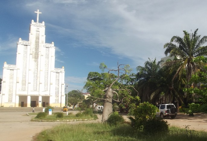
Mahajanga in Depth
History
According to Jane Hooper, "Since the tenth century, ports in the north of Madagascar, home to an Islamized population, had attracted merchants and migrants from East Africa, the Middle East, and even the Far East. At least a dozen ports were identified in northern Madagascar by the late fifteenth century by the Arab geographer Ibn Mājid...By the early eighteenth century, Andriamandisoarivo, with the support of his eight-hundred-man army, founded a new Sakalava dynasty in the north which he named Volamena, meaning red money or gold. His descendants were known as the Zafibolamena, children of the Volamena. He died in the northern city of Bezavo around 1710, having cemented his name in traditions as the founder of a powerful new kingdom.
Climate
Mahajanga has a tropical savanna climate (Köppen Aw) with two distinct seasons: a humid, rainy wet season from November to mid-April, and a sunny, less humid and practically bone-dry dry season for the remaining six-and-a-half months. Cyclones can occur during the wet season, producing very heavy rain and extensive erosion.
Sections adapted from Wikipedia: Mahajanga (CC BY-SA 4.0).
Mahajanga: Key Facts
| Population | 166,384 (2010) |
|---|---|
| Area | 53 km² |
Facts from Wikidata Q218753 (CC0).
History of Mahajanga: Empires and States
The atlas records 6 polities whose mapped territory included part of Mahajanga, from Merina Kingdom in 1824 CE to 2024 CE. They are listed in the order they first appear.
| Polity | Period here |
|---|---|
| Merina Kingdom | 1824–1897 CE |
| French Third Republic | 1898–1939 CE |
| French Africa | 1898–1957 CE |
| The French Colonial Empire | 1898–1957 CE |
| French Fourth Republic | 1945–1957 CE |
| Madagascar | 1960–2024 CE |
Historical Maps of Mahajanga
Mahajanga on the world map in each year one of these states held it:
Derived by testing mapped cities against dated territorial polygons. Dates are when the polygons cover this place, not the polity's whole lifespan, and polities absent from the source dataset are not listed.
Largest Cities in Mahajanga
6 cities mapped. Ranked by metropolitan population. A port city's harbour is written up on the page of its sea.
| # | Name | Population | Region | Role |
|---|---|---|---|---|
| 1 | Mahajanga | 154,657 | Mahajanga | Admin-1 capital |
| 2 | Marovoay | 31,253 | Mahajanga | Populated place |
| 3 | Antsohihy | 21,290 | Mahajanga | Populated place |
| 4 | Mandritsara | 9,705 | Mahajanga | Populated place |
| 5 | Maintirano | 5,925 | Mahajanga | Populated place |
| 6 | Besalampy | 1,022 | Mahajanga | Populated place |
Ports in Mahajanga
1 port mapped. Ranked by approach channel depth, the figure that limits which ships can call. Harbours link to their write-up on the page of the sea or coast they lie on. Assigned by the nearest mapped city, so features near the boundary may belong to a neighbouring division.
| # | Name | Channel Depth | Class | Sea | Max Vessel |
|---|---|---|---|---|---|
| 1 | Mahajanga | 38.4 m | Very Small | East & Southern Africa | large vessels |
UNESCO World Heritage Sites in Mahajanga
1 World Heritage Site mapped. Listed by year of inscription, earliest first. Sites shared with another country appear under each. Assigned by the nearest mapped city, so features near the boundary may belong to a neighbouring division.
| # | Name | Inscribed | Type | Criteria |
|---|---|---|---|---|
| 1 | Tsingy de Bemaraha Strict Nature Reserve | 1990 | Natural | (vii) (x) |
Mahajanga: Quick Answers
- Where is Mahajanga?
- Mahajanga is a first-level division of Madagascar, in Africa. Its mapped cities centre on 16.2141° S, 46.3797° E.
- What is the largest city in Mahajanga?
- Mahajanga is the largest city mapped in Mahajanga, with a metropolitan population of about 154,657.
- How many cities are in Mahajanga?
- YearMaps maps 6 cities and towns in Mahajanga, with a combined metropolitan population of about 223,852. This counts mapped settlements, not every municipality.