
Map of Northern Mariana Islands
Northern Mariana Islands is a country in Oceania with its capital at Saipan, home to about 43,541 people across 464 km². The interactive map below plots 1 cities and towns and 3 ports recorded for Northern Mariana Islands in YearMaps.
- Population
- 43,541
- Area
- 464 km²
- Capital
- Saipan
- Continent
- Oceania
Interactive Map of Northern Mariana Islands
Centred on Saipan at 15.2112° N, 145.7506° E. Use the layer panel to switch on rivers, dams, ports, peaks and historical borders.
About Northern Mariana Islands
The Northern Mariana Islands, officially the Commonwealth of the Northern Mariana Islands (CNMI), is an unincorporated territory and commonwealth of the United States consisting of the 14 northern islands of the Mariana Archipelago in the northwestern Pacific Ocean. The southernmost, Guam, is a separate U.S. territory. The Northern Mariana Islands were listed by the United Nations as a non-self-governing territory until 1990.
During the colonial period, the Northern Marianas were variously under the control of the Spanish, German, and Japanese empires. After World War II, the islands were part of the United Nations trust territories under American administration before formally joining the United States as a territory in 1986, with their population gaining United States citizenship.
Their area is 183.5 square miles (475.26 km2). In 2020, 47,329 people lived in the CNMI. The vast majority of the population resides on Saipan, Tinian, and Rota. The other Northern Mariana islands are sparsely inhabited; the most notable among these is Pagan, which has been largely uninhabited since a 1981 volcanic eruption.
The administrative center is Capital Hill, a village in northwestern Saipan. The current governor of the CNMI is David M. Apatang, who was elevated from lieutenant governor on July 23, 2025, following the death in office of Arnold Palacios who had served as governor since January 2023. The legislative branch has a nine-member Senate and a 20-member House of Representatives.
Summary adapted from Wikipedia: Northern Mariana Islands (CC BY-SA 4.0).

Geography and Climate of Northern Mariana Islands
Austronesian people settled the Northern Mariana Islands around 1500 B.C. These people became the indigenous Chamorro and were influenced by later migrations, including Micronesians in the first century A.D. and island Southeast Asians around 900. Spanish explorer Ferdinand MAGELLAN sailed through the Mariana Islands in 1521, and Spain claimed them in 1565. Spain formally colonized the Mariana Islands in 1668 and administered the archipelago from Guam. Spain’s brutal repression of the Chamorro, along with new diseases and intermittent warfare, reduced the indigenous population by about 90% in the 1700s. With a similar dynamic occurring on Guam, Spain forced the Chamorro from the Northern Mariana Islands to resettle there. By the time they returned, many other Micronesians, including Chuukese and Yapese, had already settled on their islands. In 1898, Spain ceded Guam to the US after the Spanish-American War but sold the Northern Mariana Islands to Germany under the German-Spanish Treaty of 1899. Germany administered the territory from German New Guinea but took a hands-off approach to day-to-day life. Following World War I, Japan administered the islands under a League of Nations mandate. Japan focused on sugar production and brought in thousands of Japanese laborers, who quickly outnumbered the Chamorro on the islands. During World War II, Japan invaded Guam from the Northern Mariana Islands and used Marianan Chamorro as translators with Guamanian Chamorro, creating friction between the two Chamorro communities that continues to this day. The US captured the Northern Mariana Islands in 1944 after the Battle of Saipan and later administered them as part of the Trust Territory of the Pacific Islands (TTPI). On four occasions in the 1950s and 1960s, voters opted for integration with Guam, which Guam rejected in 1969. In 1978, the Northern Mariana Islands was granted self-governance separate from the rest of the TTPI, and in 1986, islanders were granted US citizenship, with the territory coming under US sovereignty as the Commonwealth of the Northern Mariana Islands (CNMI). In 2009, the CNMI became the final US territory to elect a nonvoting delegate to the US Congress.
- Location
- Oceania, islands in the North Pacific Ocean, about three-quarters of the way from Hawaii to the Philippines.
- Climate
- Tropical marine; moderated by northeast trade winds, little seasonal temperature variation; dry season December to June, rainy season July to October.
- Terrain
- The southern islands in this north-south trending archipelago are limestone, with fringing coral reefs; the northern islands are volcanic, with active volcanoes on several islands.
- Highest point
- Agrihan Volcano 965 m.
- Lowest point
- Pacific Ocean 0 m.
- Coastline
- 1,482 km.
- Land borders
- Total: 0 km.
- Natural resources
- Arable land, fish.
- Land use
- Agricultural land: 1.2% (2023 est.); arable land: 0.2% (2023 est.); permanent crops: 0.2% (2023 est.); permanent pasture: 0.8% (2023 est.); forest: 53% (2023 est.); other: 45.9% (2023 est.)
- Natural hazards
- Active volcanoes on Pagan and Agrihan; typhoons (especially August to November)
- Geographic note
- Strategic location in the North Pacific Ocean.
- Languages
- Philippine languages 32.8%, Chamorro (official) 24.1%, English (official) 17%, other Pacific island languages 10.1% (includes Carolinian (official), Chinese 6.8%, other Asian languages 7.3%, other 1.9% (2010 est.)
- Religions
- Christian (Roman Catholic majority, although traditional beliefs and taboos may still be found)
- Ethnic groups
- Asian 50% (includes Filipino 35.3%, Chinese 6.8%, Korean 4.2%, and other Asian 3.7%), Native Hawaiian or other Pacific Islander 34.9% (includes Chamorro 23.9%, Carolinian 4.6%, and other Native Hawaiian or Pacific Islander 6.4%), other 2.5%, two or more ethnicities or races 12.7% (2010 est.)
- Economy
- US Pacific island commonwealth economy; growing Chinese and Korean tourist destination; hit hard by 2018 typhoon; dependent on energy imports; exempt from some US labor and immigration laws; longstanding garment production.
From the CIA World Factbook (public domain), archived edition of 2026-01-22. The Factbook is no longer updated, so figures reflect that edition.
Northern Mariana Islands in Numbers
- Population
- 43,541
- GDP
- US$1.1 billion
- GDP per person
- US$23,786
- Life expectancy
- 79.0 years
- Population growth
- -1.68% a year
- Population density
- 97 per km²
- Urban population
- 92.2%
- Surface area
- 457 km²
- Forest cover
- 53.3%
- Arable land
- 0.3%
- Access to electricity
- 100.0%
- Internet users
- 0.0%
Indicators from World Bank Open Data (CC BY 4.0). The year under each figure is its reference year.
Northern Mariana Islands in Depth
History
The islands were settled around 1500 BC when various peoples migrated there. Eventually, the islands were claimed by Spain in 1521. In the 18th century, the people of the northern Marianas were forced by Spain to relocate, and when they returned, new peoples migrated there. In 1899 Spain sold the Northern Marianas to Germany in the Spanish-German Treaty of 1899, while Guam went to the United States. At the end of World War I, with the defeat of Germany, the islands became a part of the Japanese Mandate under the League of Nations, starting in 1918. The islands were liberated from the Japanese in the Battle of Saipan in 1944, and after the war, became part of the UN Trust Territory called the Trust Territory of the Pacific Islands (TTPI).
Geography
The Northern Mariana Islands, together with Guam to the south, compose the Mariana Islands archipelago. The southern islands are limestone, with level terraces and fringing coral reefs. The northern islands are volcanic, with active volcanoes on several islands, including Anatahan, Pagan, and Agrihan. The volcano on Agrihan, Mount Agrihan, has the highest elevation at 3,166 feet (965 m). An expedition organized by John D. Mitchler and Reid Larson made the first complete ascent to the summit of this peak on June 1, 2018.
The islands going from north to south comprise 14 main islands, but some smaller islands are often grouped together. Also, Zealandia Bank can sometimes be an island, depending on the tide.
Economy
The Commonwealth of the Northern Mariana Islands benefits from its trading relationship with the federal government of the United States and cheap trained labor from Asia. The CNMI's economy has historically relied on tourism, mostly from Japan, and the garment manufacturing sector. The economy has declined since quotas were lifted in 2005, eventually leading all the garment factories in Saipan to close by February 2009. Tourism also declined after 2005 when Japan Airlines stopped serving the Marianas.
Agricultural production, primarily of tapioca, cattle, coconuts, breadfruit, tomatoes, and melons, is relatively unimportant in the economy, representing only 1.7% of CNMI GDP as of 2016.
Demographics
According to the 2020 census, the population of the CNMI was 47,329, down from 69,221 in 2000. The decrease was reportedly due to a combination of factors, including the demise of the garment industry (the vast majority of whose employees were females from China), economic crises, and a decline in tourism, one of the CNMI's primary sources of revenue.
As of the 2020 Census, except for the U.S. Minor Outlying Islands, the Northern Mariana Islands are the second least populous sub-federal jurisdiction in the United States, next to American Samoa.
Sections adapted from Wikipedia: Northern Mariana Islands (CC BY-SA 4.0).
Northern Mariana Islands: Key Facts
| Currency | United States dollar |
|---|---|
| Official languages | English, Chamorro, Carolinian |
| Head of government | David M. Apatang |
| Calling code | +1670 |
| Internet domain | .mp |
| Highest point | Mount Agrihan |
| Lowest point | Pacific Ocean |
| Established | 1898 |
Facts from Wikidata Q16644 (CC0).
Visiting Northern Mariana Islands
The Commonwealth of the Northern Mariana Islands (CNMI) is a territory of the United States in Micronesia, visited mainly by tourists from East Asia. The Marianas' top activity among Americans is scuba diving and snorkeling. In addition to the coral reefs you might expect, the waters around the islands were the scene of fierce fighting during World War II and there are many ship wrecks and even rusting tanks stuck on the seabed. Many Asian (particularly South Korean) visitors come to the CNMI for gambling (especially on Tinian), and karaoke/hostess bars.
Travel notes adapted from Wikivoyage: Northern Mariana Islands (CC BY-SA 4.0).
Largest Cities in Northern Mariana Islands
1 city recorded. Ranked by metropolitan population. A port city's harbour is written up on the page of its sea.
| # | Name | Population | Region | Role |
|---|---|---|---|---|
| 1 | Capitol Hill | 2,500 | — | Admin-1 capital |
Ports in Northern Mariana Islands
3 ports recorded. Ranked by approach channel depth, the figure that limits which ships can call. Harbours link to their write-up on the page of the sea or coast they lie on.
Largest Islands of Northern Mariana Islands
4 islands recorded. Ranked by mapped area. An island divided between countries is listed under each, with the area of the whole island.
| # | Name | Area | Type |
|---|---|---|---|
| 1 | Mariana Isands | 76,699 km² | Island group |
| 2 | Saipan | 133 km² | Island |
| 3 | Rota | 97 km² | Island |
| 4 | Anatahan | 81 km² | Island |

Saipan
Island · 133 km²
Saipan is an island in Oceania (Micronesia), covering an estimated 133 km². It extends across the Northern Mariana Islands and the United States.
Saipan () is the largest island and capital of the Northern Mariana Islands, an unincorporated territory of the United States in the western Pacific Ocean. According to 2020 estimates by the United States Census Bureau, the population of Saipan was 43,385. Its people have been United States citizens since the 1980s. Saipan is one of the main homes of the Chamorro and the Carolinians, the indigenous people of the Mariana Islands.
From the 17th century, the island experienced Spanish occupation and rule until the Spanish–American War of 1898, when Saipan was briefly occupied by the United States, before being formally sold to Germany. About 15 years of German rule were followed by 30 years of Japanese rule, which was ended by the Battle of Saipan, as the United States began to take control of the Philippine Sea. Following World War II, Saipan became part of the Trust Territory of the Pacific Islands, and was administered by the United States, along with the rest of the Northern Marianas. In 1978, Saipan formally joined the United States as part of the Commonwealth of the Northern Mariana Islands.
Today, Saipan is home to about 90% of the population of the Northern Mariana Islands.
Adapted from Wikipedia: Saipan, Northern Mariana Islands (CC BY-SA 4.0).
- Feature class
- Island
- Mapped extent
- 133 km²
- Size rank
- #379 of 445 islands
- Region
- Oceania
- Subregion
- Micronesia
- Countries
- Northern Mariana Islands, United States
- Coordinates
- 15.1887°, 145.7345°
- Ranges:
- New Guinea Highlands (Oceania), Maoke Mountains (Oceania)
More about Saipan
Geography
Saipan is the largest island in the Northern Mariana Islands. It is about 120 mi (190 km) north of Guam and 5 nautical miles (9.3 km) northeast of Tinian, from which it is separated by the Saipan Channel. Saipan is about 12 mi (19 km) long and 5.6 mi (9.0 km) wide, with a land area of 115.38 km2 (44.55 sq mi).
The western side of the island is lined with sandy beaches and an offshore coral reef creates a large lagoon. The eastern shore is composed primarily of rugged rocky cliffs and a reef. A narrow underwater bank of Marpi Reef lies 28 mi (45 km) north of Saipan, and CK Reef lies in the west of the island.
The highest elevation on Saipan is a limestone-covered mountain called Mount Tapochau at 1,560 ft (480 m).
History
Traces of human settlements on Saipan have been found by archaeologists ranging over 4,000 years, including petroglyphs, ancient Latte Stones, and other artifacts pointing to cultural affinities with Melanesia and with similar stone monuments in Micronesia and Palau.
Saipan, together with Tinian, was possibly first sighted by Europeans during the Spanish expedition of Ferdinand Magellan, when it made a landing in the southern Marianas on March 6, 1521. It is likely Saipan was sighted by Gonzalo Gómez de Espinosa in 1522 on board the Spanish ship Trinidad, which he commanded after the death of Ferdinand Magellan in the Battle of Mactan in Cebu, Philippines. This is likely to have occurred after the sighting of the Maug Islands between the end of August and the end of September 1522.
Demographics
According to the 2010 United States census, Saipan's population was 48,220, a drop of 22.7% from the 2000 US Census; the population decrease is largely attributed to working immigrants and their families either returning to their home countries after the collapse of the garment industry or moving to other locations with economic opportunities such as Guam and the United States mainland. The population of Saipan corresponds to approximately 90% of the population of the Northern Mariana Islands.
Large numbers of Filipino, Chinese, Bangladeshi, Nepalese and smaller numbers of Sri Lankan and Burmese unskilled workers and professionals migrated to the Northern Mariana Islands including Saipan during the late 1900s, mostly during the 1980s and 1990s.
Economy
Tourism had traditionally been a vital source of the island's revenue and economic activities. But in the 1980s, garment manufacturing became one of the main economic driving forces in Saipan when the U.S. government agreed that the CNMI would be exempted from certain federal minimum wage and immigration laws.
Sections adapted from Wikipedia: Saipan, Northern Mariana Islands (CC BY-SA 4.0).
Saipan: Key Facts
| Area | 115 km² |
|---|---|
| Population | 48,220 (2010) |
| Highest point | Mount Tapochau |
| Surrounded by | Pacific Ocean |
Facts from Wikidata Q51679 (CC0).

Rota
Island · 97 km²
Rota is an island in Oceania (Micronesia), covering an estimated 97 km². It extends across the Northern Mariana Islands and the United States.
Rota (Chamorro: Luta), also known as the "Friendly Island", is the southernmost island of the United States Commonwealth of the Northern Mariana Islands (CNMI) and the third southernmost of the Marianas Archipelago (the first being Cocos Island). Early Spanish records called it Zarpana; the name Rota may have come from the Andalusian municipality of Rota. It lies approximately 40 nautical miles (74 km) north-northeast of the separately administered United States territory of Guam. Sinapalo village is the largest and most populated, followed by Songsong village. Rota functions as one of the four municipalities of the CNMI.
Adapted from Wikipedia: Rota, Northern Mariana Islands (CC BY-SA 4.0).
- Feature class
- Island
- Mapped extent
- 97 km²
- Size rank
- #389 of 445 islands
- Region
- Oceania
- Subregion
- Micronesia
- Countries
- Northern Mariana Islands, United States
- Coordinates
- 14.1496°, 145.2090°
- Ranges:
- New Guinea Highlands (Oceania), Maoke Mountains (Oceania)
More about Rota
Geography
Rota is 12.3 miles (19.8 km) long and 4.2 mi (6.8 km) wide. Its coastline is about 38 mi (61 km) long. The highest point on Rota is Mt. Sabana which is 495.56 meters (1,625.9 ft). Rota is 47 nmi (87 km) north of Guam, 63 nmi (117 km) south of Tinian and 73 nmi (135 km) south of Saipan.
Rota has diverse flora and fauna including the endemic and endangered Rota white-eye, Mariana crow, and Mariana fruit bat. Much of the island, especially where there are remnants of native forest, have been recognised as forming an Important Bird Area (IBA) by BirdLife International. Four wildlife conservations areas have been designated on Rota: Mariana Crow Conservation Area, Sabana Protected Area, I'Chenchon Park Wildlife Conservation Area, and Liyo Conservation Area.
History
In 1521, the first European to see Rota was the lookout on Ferdinand Magellan's ship Victoria, Lope Navarro. However, Magellan's armada of three ships did not stop until they reached Guam, so the first European to arrive in Rota (in 1524), was the Spanish navigator Juan Sebastián Elcano, who annexed it together with the rest of the Mariana Islands on behalf of the Spanish Empire.
As with the other islands of the northern Marianas, Rota was sold to the German Empire under the German–Spanish Treaty of 1899. In World War I, the islands were occupied by the Empire of Japan. In 1919, the League of Nations formally recognized Japanese control under the South Seas Mandate.
Sections adapted from Wikipedia: Rota, Northern Mariana Islands (CC BY-SA 4.0).
Rota: Key Facts
| Area | 85.4 km² |
|---|---|
| Population | 3,283 |
| Surrounded by | Pacific Ocean |
Facts from Wikidata Q949090 (CC0).
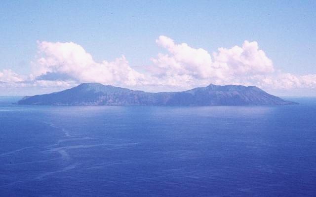
Anatahan
Island · 81 km²
Anatahan is an island in Oceania (Micronesia), covering an estimated 81 km². It extends across the Northern Mariana Islands and the United States.
Anatahan is a volcanic island in the Northern Mariana Islands in the Pacific Ocean, and has one of the most active volcanoes of the archipelago. Formerly inhabited, the island is currently uninhabited due to the constant danger of volcanic eruptions. Anatahan is located 60 kilometers (37 mi; 32 nmi) northwest of Farallon de Medinilla and 120 km (75 mi; 65 nmi) north of Saipan. It last erupted between 2007 and 2008, and also erupted in 2003.
Anatahan is the site of a curious World War II tale in which about 30 Japanese soldiers stayed here, holding out after the war ended in 1945 until 1951 before surrendering; during that time, they lived with a local woman until 1950. Afterwards, the island was inhabited until 1990, when an earthquake struck, leading to its evacuation.
Adapted from Wikipedia: Anatahan (CC BY-SA 4.0).
- Feature class
- Island
- Mapped extent
- 81 km²
- Size rank
- #413 of 445 islands
- Region
- Oceania
- Subregion
- Micronesia
- Countries
- Northern Mariana Islands, United States
- Coordinates
- 16.3638°, 145.6714°
- Ranges:
- New Guinea Highlands (Oceania), Maoke Mountains (Oceania)
More about Anatahan
Geography
Anatahan is roughly elliptical in shape, with a length of 9 kilometers (5.6 mi) and a width of 4 km (2.5 mi) and an area of 33.9 km2 (13.1 sq mi). The island is the summit of a stratovolcano which reaches an altitude of 790 m (2,592 ft) above sea level at its highest peak.
The volcano is topped by a caldera, 2.3 km (1.4 mi) wide, which is divided into an eastern and western portion, with the eastern portion around 250 m (820 ft) lower than the western. Sparseness of vegetation in the most recent lava flows on Anatahan indicated that they were of Holocene age. In April 1990, the inhabitants of the western coast of the island were evacuated after earthquake swarms and active fumaroles indicated that an eruption might be imminent, but no eruption occurred at that time.
History
The island was first charted by Europeans in late October 1543 by Spanish explorer Bernardo de la Torre on board of the carrack San Juan de Letrán when trying to return from Sarangani to New Spain. At the time, the island was settled by the Chamorros. In 1695, the natives were forcibly removed to Saipan and, three years later, to Guam. Under Spanish rule, coconut plantations were developed for the production of copra. In 1884, an estimated 125 tons were exported.
Following the sale of the Northern Marianas by Spain to the German Empire in 1899, Anatahan was administered as part of German New Guinea. However, by May 1901 the island was reported as uninhabited.
Demographics
In 1980, the population of Anatahan was one family. The people resided on Anatahan when school was not in session.
The island was evacuated in 1990 after an earthquake, and 2010 and 2020 census data both showed its population as 0.
Sections adapted from Wikipedia: Anatahan (CC BY-SA 4.0).
Anatahan: Key Facts
| Area | 33.9 km² |
|---|---|
| Population | 23 (1990) |
| Surrounded by | Pacific Ocean |
Facts from Wikidata Q487319 (CC0).
More Maps in Oceania
Northern Mariana Islands: Quick Answers
- What is the capital of Northern Mariana Islands?
- The capital of Northern Mariana Islands is Saipan.
- What is the population of Northern Mariana Islands?
- Northern Mariana Islands has a population of about 43,541, the #211 largest of 225 countries in YearMaps. Source: World Bank, 2025.
- How big is Northern Mariana Islands?
- Northern Mariana Islands covers 464 km², ranking #200 by area, with about 94 people per square kilometre.
- Which continent is Northern Mariana Islands in?
- Northern Mariana Islands is in Oceania.
- What is the largest city in Northern Mariana Islands?
- Capitol Hill is the largest city in Northern Mariana Islands, with a metropolitan population of about 2,500.