
Map of Palau
Palau is a country in Oceania with its capital at Ngerulmud, home to about 17,663 people across 466 km². The interactive map below plots 2 cities and towns, 1 mountain summits and 1 ports recorded for Palau in YearMaps.
- Population
- 17,663
- Area
- 466 km²
- Capital
- Ngerulmud
- Continent
- Oceania
Interactive Map of Palau
Centred on Ngerulmud at 7.4874° N, 134.6266° E. Use the layer panel to switch on rivers, dams, ports, peaks and historical borders.
About Palau
Palau, officially the Republic of Palau, is an island country located in the Micronesia subregion of Oceania in the western Pacific Ocean. The Republic of Palau consists of approximately 340 islands and is the western part of the Caroline Islands, while the eastern and central parts make up the Federated States of Micronesia.
It has a total area of 466 square kilometers (180 sq mi), making it the sixteenth smallest country in the world. The most populous island is Koror, home to the country's most populous city of the same name. The capital, Ngerulmud, is located on the largest island of Babeldaob, in Melekeok State. Palau shares maritime boundaries with international waters to the north, the Federated States of Micronesia to the east, Indonesia to the south, and the Philippines to the northwest.
The country was originally settled approximately 1,000 BCE by migrants from Maritime Southeast Asia. Palau was first drawn on a European map by the Bohemian missionary Paul Klein based on a description given by a group of Palauans shipwrecked on the Philippine coast on Samar. The Palau islands were made part of the Spanish East Indies in 1885. Following Spain's defeat in the Spanish–American War in 1898, the islands were sold to Germany in 1899 under the terms of the German–Spanish Treaty, where they were administered as part of German New Guinea.
After World War I, the islands were made a part of the Japanese-ruled South Seas Mandate by the League of Nations. During World War II, skirmishes including the major Battle of Peleliu were fought between American and Japanese troops as part of the Mariana and Palau Islands campaign. Along with other Pacific Islands, Palau was made a part of the United States–governed Trust Territory of the Pacific Islands in 1947. Having voted in a referendum against joining the Federated States of Micronesia in 1978, the islands gained full sovereignty in 1994 under a Compact of Free Association with the United States.
Politically, Palau is a presidential republic in free association with the United States, which provides defense, funding, and access to social services. Legislative power is concentrated in the bicameral Palau National Congress. Palau's economy is based mainly on tourism, subsistence agriculture, and fishing, with a significant portion of gross national product (GNP) derived from foreign aid. The country uses the United States dollar as its official currency. The islands' culture mixes Micronesian, Melanesian, Asian, and Western elements.
Summary adapted from Wikipedia: Palau (CC BY-SA 4.0).

Geography and Climate of Palau
Humans arrived in the Palauan archipelago from Southeast Asia around 1000 B.C. and developed a complex, highly organized matrilineal society where high-ranking women picked the chiefs. The islands were the westernmost part of the widely scattered Pacific islands north of New Guinea that Spanish explorers named the Caroline Islands in the 17th century. The 18th and 19th centuries saw occasional visits of whalers and traders as Spain gained some influence in the islands and administered it from the Philippines. Spain sold Palau to Germany in 1899 after losing the Philippines in the Spanish-American War. Japan seized Palau in 1914, was granted a League of Nations mandate to administer the islands in 1920, and made Koror the capital of its South Seas Mandate in 1922. By the outbreak of World War II, there were four times as many Japanese living in Koror as Palauans. In 1944, the US invasion of the island of Peleliu was one of the bloodiest island fights of the Pacific War. After the war, Palau became part of the US-administered Trust Territory of the Pacific Islands. Palau voted against joining the Federated States of Micronesia in 1978 and adopted its own constitution in 1981, which stated that Palau was a nuclear-free country. In 1982, Palau signed a Compact of Free Association (COFA) with the US, which granted Palau financial assistance and access to many US domestic programs in exchange for exclusive US military access and defense responsibilities. However, many Palauans saw the COFA as incompatible with the Palauan Constitution because of the US military’s nuclear arsenal, and seven referenda failed to achieve ratification. Following a constitutional amendment and eighth referendum in 1993, the COFA was ratified and entered into force in 1994 when the islands gained their independence. Its funding was renewed in 2010. Palau has been on the frontlines of combatting climate change and protecting marine resources. In 2011, Palau banned commercial shark fishing and created the world’s first shark sanctuary. In 2017, Palau began stamping the Palau Pledge into passports, reminding visitors to act in ecologically and culturally responsible ways. In 2020, Palau banned coral reef-toxic sunscreens and expanded its fishing prohibition to include 80% of its exclusive economic zone.
- Location
- Oceania, group of islands in the North Pacific Ocean, southeast of the Philippines.
- Climate
- Tropical; hot and humid; wet season May to November.
- Terrain
- Varying topography from the high, mountainous main island of Babelthuap to low, coral islands usually fringed by large barrier reefs.
- Highest point
- Mount Ngerchelchuus 242 m.
- Lowest point
- Pacific Ocean 0 m.
- Coastline
- 1,519 km.
- Land borders
- Total: 0 km.
- Natural resources
- Forests, minerals (especially gold), marine products, deep-seabed minerals.
- Land use
- Agricultural land: 9.3% (2023 est.); arable land: 0.7% (2023 est.); permanent crops: 4.3% (2023 est.); permanent pasture: 4.3% (2023 est.); forest: 90.6% (2023 est.); other: 0% (2023 est.)
- Natural hazards
- Typhoons (June to December)
- Geographic note
- Westernmost archipelago in the Caroline chain, consists of six island groups totaling more than 300 islands; includes world-famous Rock Islands.
- Languages
- Palauan (official on most islands) 65.2%, other Micronesian 1.9%, English (official) 19.1%, Filipino 9.9%, Chinese 1.2%, other 2.8% (2015 est.)
- Religions
- Roman Catholic 46.9%, Protestant 30.9% (Evangelical 24.6%, Seventh Day Adventist 5%, other Protestant 1.4%), Modekngei 5.1% (indigenous to Palau), Muslim 4.9%, other 12.3% (2020 est.)
- Ethnic groups
- Palauan (Micronesian with Malayan and Melanesian admixtures) 70.6%, Carolinian 1.2%, Asian 26.5%, other 1.7% (2020 est.)
- Economy
- High-income Pacific island economy; environmentally fragile; subsistence agriculture and fishing industries; US aid reliance; rebounding post-pandemic tourism industry and services sector; very high living standard and low unemployment.
From the CIA World Factbook (public domain), archived edition of 2026-01-22. The Factbook is no longer updated, so figures reflect that edition.
Palau in Numbers
- Population
- 17,663
- GDP
- US$345.0 million
- GDP per person
- US$19,532
- Life expectancy
- 69.4 years
- Population growth
- -0.18% a year
- Population density
- 38 per km²
- Urban population
- 79.3%
- Surface area
- 460 km²
- Forest cover
- 90.8%
- Arable land
- 0.7%
- Access to electricity
- 100.0%
- Internet users
- 83.9%
Indicators from World Bank Open Data (CC BY 4.0). The year under each figure is its reference year.
Palau in Depth
History
Palau was originally settled between the 3rd and 2nd millennia BCE by Austronesian peoples, most likely from what is now the Philippines or Indonesia. Sonsorol was sighted by the Spanish as early as 1521, when the Spanish mission of the Trinidad, the flagship of Ferdinand Magellan's voyage of circumnavigation, sighted two small islands around the 5th parallel north, naming them "San Juan".
In December 1696, a group of sailors from the Caroline Islands were stranded on Samar, near Guiuan, when they met European missionary Paul Klein. Using pebbles, the sailors attempted to show Klein the approximate location and size of the islands. He used this information to produce the first European map of the Palau area.
Geography
Palau's territory consists of an archipelago located in the Pacific Ocean. Its most populous islands are Angaur, Babeldaob, Koror and Peleliu. The latter three lie together within the same barrier reef, while Angaur is an oceanic island several kilometers to the south. About two-thirds of the population lives on Koror. The coral atoll of Kayangel is north of these islands, while the uninhabited Rock Islands (about 200) are west of the main island group. A remote group of six islands, known as the Southwest Islands, some 604 kilometers (375 miles) from the main islands, make up the states of Hatohobei and Sonsorol.
Palau has a tropical rainforest climate with an annual mean temperature of 28 °C (82 °F). Rainfall is heavy throughout the year, averaging 3,800 mm (150 in).
Economy
Palau's economy consists primarily of tourism, subsistence agriculture, and fishing. Tourist activity focuses on scuba diving and snorkeling in the islands' rich marine environment, including its barrier reefs' walls and World War II wrecks. In April 2022, Palau launched Ol'au Palau, a responsible tourism program aimed to preserve the country's natural environment and traditional culture. The government is the largest employer, relying heavily on US financial assistance. Business and tourist arrivals numbered 65,558 in fiscal year 2025.
Although Palau's ship registry represents less than 0.001% of the world fleet of commercial ships, it contains almost 60% of last-voyage flags in 2019. It suggests that the registry is used by shipping companies to evade end-of-life responsibilities.
Demographics
The population of Palau is approximately 21,947 (2025), 73% of whom are native Palauans of mixed Melanesian and Austronesian descent. There are many Asian communities within Palau. Filipinos form the largest Asian group and second largest ethnic group in the country, dating back to the Spanish colonial period. There are significant numbers of Chinese and Koreans. There are also smaller numbers of Palauans of mixed or full Japanese ancestry.
Sections adapted from Wikipedia: Palau (CC BY-SA 4.0).
Palau: Key Facts
| Currency | United States dollar |
|---|---|
| Official languages | English, Palauan, Japanese |
| Head of state | Surangel Whipps Jr. |
| Head of government | Surangel Whipps Jr. |
| Calling code | +680 |
| Internet domain | .pw |
| Highest point | Mount Ngerchelchuus |
| Lowest point | Pacific Ocean |
| Established | 1 October 1994 |
Facts from Wikidata Q695 (CC0).
Largest Cities in Palau
2 cities recorded. Ranked by metropolitan population. A port city's harbour is written up on the page of its sea.
| # | Name | Population | Region | Role |
|---|---|---|---|---|
| 1 | Koror | 11,200 | — | Populated place |
| 2 | Melekeok | 7,026 | — | National capital |
Highest Mountains in Palau
1 mountain recorded. Ranked by summit elevation above sea level. A summit on a border is listed under both countries.
| # | Name | Elevation | Feet | Region |
|---|---|---|---|---|
| 1 | Mount Ngerchelchauus | 242 m | 794 ft | Oceania |
Ports in Palau
1 port recorded. Ranked by approach channel depth, the figure that limits which ships can call. Harbours link to their write-up on the page of the sea or coast they lie on.
| # | Name | Channel Depth | Class | Sea | Max Vessel |
|---|---|---|---|---|---|
| 1 | Malakal Harbor | 31.1 m | Very Small | Pacific Islands & Hawaii | medium vessels |
UNESCO World Heritage Sites in Palau
1 World Heritage Site recorded. Listed by year of inscription, earliest first. Sites shared with another country appear under each.
| # | Name | Inscribed | Type | Criteria |
|---|---|---|---|---|
| 1 | Rock Islands Southern Lagoon | 2012 | Mixed | (iii) (v) (vii) (ix) (x) |
Largest Islands of Palau
2 islands recorded. Ranked by mapped area. An island divided between countries is listed under each, with the area of the whole island.
| # | Name | Area | Type |
|---|---|---|---|
| 1 | Caroline Islands | 1.75M km² | Island group |
| 2 | PALAU Islands | 27,271 km² | Island group |
Caroline Islands
Island group · 1.75M km²
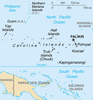
Caroline Islands is an island group in Oceania (Micronesia), covering an estimated 1.75M km². It extends across Palau and Micronesia. It is the 6th-largest of the 445 islands with a mapped extent in YearMaps.
The Caroline Islands (or the Carolines) are a widely scattered archipelago of tiny islands in the western Pacific Ocean, to the north of New Guinea. Politically, they are divided between the Federated States of Micronesia (FSM) in the central and eastern parts of the group, and Palau at the extreme western end. Historically, this area was also called Nuevas Filipinas or New Philippines, because they were part of the Spanish East Indies and were governed from Manila in the Philippines.
The Carolines are scattered across a distance of approximately 3,540 kilometers (2,200 mi; 1,910 nmi), from the westernmost island, Tobi, in Palau, to the easternmost island, Kosrae, a state of the FSM.
Adapted from Wikipedia: Caroline Islands (CC BY-SA 4.0).
- Feature class
- Island group
- Mapped extent
- 1.75M km²
- Size rank
- #6 of 445 islands
- Region
- Oceania
- Subregion
- Micronesia
- Countries
- Palau, Micronesia
- Coordinates
- 4.3577°, 157.4944°
- Ranges:
- Owen Stanley Range (Oceania), New Guinea Highlands (Oceania)
- Settlements:
- Melekeok (2,553 km)
More about Caroline Islands
History
Different islands in the Carolines have passed down different legends about the origins and early histories of their peoples. For example, on Pohnpei, the islanders describe their history before colonial times as divided into three eras: the Mwehin Kawa or Mwehin Aramas (era of building or peopling, before 1100); the Mwehin Sau Deleur (era of the reigns of the Saudeleur, from 1100 to around 1628); and the Mwehin Nahnmwarki (era of the tribal chiefs, from around 1628 to 1885, when Spain colonized the islands).
Description
The group consists of about 500 small coral islands, east of the Philippines, in the Pacific Ocean. The distance from Yap (one of the larger Caroline islands) to Manila is 1,200 mi (1,900 km).
Most of the islands are made up of low, flat coral atolls, but there are some that rise high above sea level.
Sections adapted from Wikipedia: Caroline Islands (CC BY-SA 4.0).
Caroline Islands: Key Facts
| Area | 1,160 km² |
|---|---|
| Population | 125,000 (2010) |
| Highest point | Dolohmwar |
| Surrounded by | Pacific Ocean |
Facts from Wikidata Q118350 (CC0).
Countries Bordering Palau
Land and maritime neighbours.
More Maps in Oceania
Palau: Quick Answers
- What is the capital of Palau?
- The capital of Palau is Ngerulmud.
- What is the population of Palau?
- Palau has a population of about 17,663, the #218 largest of 225 countries in YearMaps. Source: World Bank, 2025.
- How big is Palau?
- Palau covers 466 km², ranking #199 by area, with about 38 people per square kilometre.
- Which continent is Palau in?
- Palau is in Oceania.
- Which countries border Palau?
- Palau shares a land or maritime border with Indonesia, Micronesia, Philippines.
- What is the largest city in Palau?
- Koror is the largest city in Palau, with a metropolitan population of about 11,200.
- What is the highest mountain in Palau?
- The highest summit recorded for Palau in YearMaps is Mount Ngerchelchauus at 242 m (794 ft). Summits on a border are counted for both countries.