Skip to content
YearMaps
Papua New Guinea · Islands

Largest Islands of Papua New Guinea

New Guinea is the largest of the 10 islands recorded for Papua New Guinea, at 785,443 km², ahead of Bismarck Archipelago at 534,907 km². The full list follows.

How this list is built: Ranked by mapped area. An island divided between countries is listed under each, with the area of the whole island. It covers the islands indexed in YearMaps, drawn from open geospatial data, and is not an exhaustive national register.

Islands Listed
10
Top Ranked
785,443 km²
New Guinea
Second
534,907 km²
Bismarck Archipelago
Profiled Below
10
Photo, encyclopedia text and figures
Largest Islands of Papua New Guinea
#NameArea
1New Guinea785,443 km²
2Bismarck Archipelago534,907 km²
3New Britain35,988 km²
4Louisiade Archipelago17,183 km²
5D’Entrecasteaux Islands12,017 km²
6Bougainville8,751 km²
7New Ireland6,961 km²
8Manus1,853 km²
9Mussau416 km²
10Karkar371 km²

The Islands of Papua New Guinea in Detail

The 10 islands above that have an encyclopedia article, in the same order, each with its photograph, figures and the places around it.

New Guinea
Image via Wikimedia Commons (author and licence on the file page).

New Guinea

Island · 785,443 km²

New Guinea is an island in Oceania (Melanesia), covering an estimated 785,443 km². It extends across Indonesia and Papua New Guinea. About 45% of the island belongs to Papua New Guinea, and the rest to Indonesia. It is the 11th-largest of the 445 islands with a mapped extent in YearMaps.

New Guinea (Tok Pisin: Niugini; Hiri Motu: Niu Gini; Indonesian: Papua, fossilized Nugini, also known as Papua or historically Irian) is the world's second-largest island, with an area of 785,753 km2 (303,381 sq mi). It has the third-largest remaining rainforest globally, and the highest plant biodiversity of any island.

Located in Melanesia in the southwestern Pacific Ocean, the island is separated from Australia by the 150-kilometre (81-nautical-mile; 93-mile) wide Torres Strait. Both landmasses lie on the same continental shelf, and were united during episodes of low sea level in the Pleistocene glaciations as the combined landmass of Sahul. Numerous smaller islands are located to the west and east. The island's name was given by Spanish explorer Yñigo Ortiz de Retez during his maritime expedition of 1545, due to the perceived resemblance of the indigenous peoples of the island to those in the African region of Guinea.

The eastern half of the island is the major land mass of the nation of Papua New Guinea.

Adapted from Wikipedia: New Guinea (CC BY-SA 4.0).

Feature class
Island
Mapped extent
785,443 km²
Size rank
#11 of 445 islands
Region
Oceania
Subregion
Melanesia
Countries
Indonesia, Papua New Guinea
Coordinates
-7.0509°, 141.3145°
Summits:
Mount Wilhelm (4,509 m), Ulawun (2,334 m), Mount Balbi (2,715 m)
Ranges:
New Guinea Highlands (Oceania), Owen Stanley Range (Oceania)
Settlements:
Mendi (58 km), Mount Hagen (92 km), Goroka (177 km)

View on the live map

More about New Guinea

Geography

New Guinea is an island to the north of the Australian mainland, south of the equator. It is isolated by the Arafura Sea to the west, and the Torres Strait and Coral Sea to the east. Sometimes considered to be the easternmost island of the Indonesian archipelago, it lies north of Australia's Top End, the Gulf of Carpentaria and Cape York Peninsula, and west of the Bismarck Archipelago and the Solomon Islands archipelago. Biologically, New Guinea may also be considered contiguous with northern Australia, as there is a continuity of flora and fauna between the two regions.

History

Archaeological evidence indicates that humans arrived on New Guinea perhaps 60,000 years ago, although this is under debate. They came probably by sea from Southeast Asia during the Last Glacial Period, when the sea was lower and distances between islands shorter.

The first inhabitants, from whom the Papuan people are probably descended, adapted to the range of ecologies and, in time, developed one of the earliest known agricultures. Remains of this agricultural system, in the form of ancient irrigation systems in the highlands of Papua New Guinea, are being studied by archaeologists. Research indicates that the highlands were an early and independent center of agriculture, with evidence of irrigation going back at least 10,000 years.

Biodiversity and ecology

With some 786,000 km2 of tropical land—less than one-half of one percent (0.5%) of the Earth's surface—New Guinea has an immense biodiversity, containing between 5 and 10 percent of the total species on the planet. This percentage is about the same amount as that found in the United States or Australia. A high percentage of New Guinea's species are endemic, and thousands are still unknown to science: probably well over 200,000 species of insect, between 11,000 and 20,000 plant species, and over 650 resident bird species. Most of these species are shared, at least in their origin, with the continent of Australia, which was until fairly recent geological times part of the same landmass (see Australia-New Guinea for an overview).

Demographics

The current population of the island of New Guinea is about fifteen million. Archaeological evidence indicates that humans may have inhabited the island continuously since 50,000 BCE, and first settlement possibly dating back to 60,000 years ago has been proposed. The island is presently populated by almost a thousand different tribal groups and a near-equivalent number of separate languages, which makes New Guinea the most linguistically diverse area in the world. Ethnologue's 14th edition lists 826 languages of Papua New Guinea and 257 languages of Western New Guinea, total 1073 languages, with 12 languages overlapping.

Sections adapted from Wikipedia: New Guinea (CC BY-SA 4.0).

New Guinea: Key Facts

Key facts about New Guinea
Area785,753 km²
Population11,300,000
Highest pointPuncak Jaya
Surrounded byBismarck Sea, Solomon Sea

Facts from Wikidata Q40285 (CC0).

Visiting New Guinea

New Guinea is the second largest non-continental island in the world (with the world's largest being Greenland), situated to the north of Australia. It has a north-south border that divides the island into east and west divisions. The island is also home to the only land border in Oceania, as well as the highest mountain in Oceania too, making up one of the eight Seven summits.

Travel notes adapted from Wikivoyage: New Guinea (CC BY-SA 4.0).

Bismarck Archipelago
Image via Wikimedia Commons (author and licence on the file page).

Bismarck Archipelago

Island group · 534,907 km²

Bismarck Archipelago is an island group in Oceania (Melanesia), covering an estimated 534,907 km². It is the 19th-largest of the 445 islands with a mapped extent in YearMaps.

The Bismarck Archipelago (German: Bismarck-Archipel, pronounced [ˈbɪsmaʁk ˌaʁçiˈpeːl]) is a group of islands located just off the northeastern coast of New Guinea in the western Pacific Ocean, part of the Islands Region of Papua New Guinea. Its area is about 50,000 square kilometres (19,000 sq mi).

Adapted from Wikipedia: Bismarck Archipelago (CC BY-SA 4.0).

Feature class
Island group
Mapped extent
534,907 km²
Size rank
#19 of 445 islands
Region
Oceania
Subregion
Melanesia
Coordinates
-3.4261°, 148.8714°
Summits:
Ulawun (2,334 m), Mount Wilhelm (4,509 m), Mount Balbi (2,715 m)
Ranges:
New Guinea Highlands (Oceania), Owen Stanley Range (Oceania)
Settlements:
Madang (396 km), Lae (423 km), Goroka (486 km)

View on the live map

More about Bismarck Archipelago

History

The first inhabitants of the archipelago arrived around 30,000–40,000 years ago. They may have traveled from New Guinea, by boat across the Bismarck Sea or via a temporary land bridge, created by an uplift in the Earth's crust. Later arrivals included the Lapita people, the direct ancestors of the Austronesian peoples of Polynesia, eastern Micronesia, and Island Melanesia.

The first European to visit these islands was Dutch explorer Jacob le Maire in 1616. The islands remained unsettled by western Europeans until they were annexed as part of the German protectorate of German New Guinea in 1884. The area was named in honour of the Chancellor Otto von Bismarck.

On 13 March 1888, a volcano erupted on Ritter Island causing a megatsunami.

Sections adapted from Wikipedia: Bismarck Archipelago (CC BY-SA 4.0).

Bismarck Archipelago: Key Facts

Key facts about Bismarck Archipelago
Area49,700 km²
Surrounded byBismarck Sea

Facts from Wikidata Q154628 (CC0).

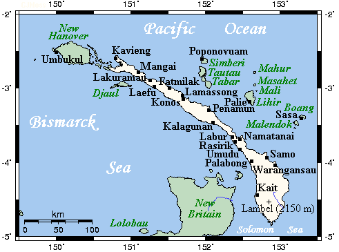
New Britain
Image via Wikimedia Commons (author and licence on the file page).

New Britain

Island group · 35,988 km²

New Britain is an island group in Oceania (Melanesia), covering an estimated 35,988 km².

New Britain (Tok Pisin: Niu Briten) is the largest island in the Bismarck Archipelago, part of the Islands Region of Papua New Guinea. It is separated from New Guinea by a northwest corner of the Solomon Sea (or with an island hop of Umboi the Dampier and Vitiaz Straits) and from New Ireland by St. George's Channel. The main towns of New Britain are Rabaul, Kokopo, and Kimbe. The island is roughly the size of Taiwan.

When the island was part of German New Guinea, its name was Neupommern ("New Pomerania"). In common with most of the Bismarcks it was largely formed by volcanic processes, and has active volcanoes including Ulawun (highest volcano nationally), Langila, the Garbuna Group, the Sulu Range, and the volcanoes Tavurvur and Vulcan of the Rabaul caldera. A major eruption of Tavurvur in 1994 destroyed the East New Britain provincial capital of Rabaul. Most of the town still lies under metres of ash, and the capital has been moved to nearby Kokopo.

Adapted from Wikipedia: New Britain (CC BY-SA 4.0).

Feature class
Island group
Mapped extent
35,988 km²
Size rank
#92 of 445 islands
Region
Oceania
Subregion
Melanesia
Coordinates
-5.9045°, 149.8961°
Summits:
Ulawun (2,334 m), Mount Wilhelm (4,509 m), Mount Balbi (2,715 m)
Ranges:
Owen Stanley Range (Oceania), New Guinea Highlands (Oceania)
Settlements:
Lae (334 km), Popondetta (367 km), Madang (461 km)

View on the live map

More about New Britain

Geography

New Britain extends from 148°18′28″ to 152°24′15″ E longitude and from 4°08′00″ to 6°18′57″ S latitude. It is crescent-shaped, approximately 520 km (320 mi) along its southeastern coastline, and from 29 to 146 km (18 to 91 mi) wide, not including a small central peninsula. The air-line distance from west to east is 477 km (296 mi). The island is the 38th largest in the world, with an area of 35,140 km2 (13,570 sq mi).

Steep cliffs form some sections of the coastline; in others the mountains are further inland, and the coastal area is flat and bordered by coral reefs. The highest point, at 2,334 metres (7,657 ft), is the stratovolcano Mount Ulawun in the east. Most of the terrain is covered with tropical rainforest, and several large rivers are fed by the high rainfall.

History

In research science, there is evidence with Pleistocene-era cultural deposits discovered in open-site excavations in near Yombon, which show that New Britain has been inhabited by indigenous Papuans for thousands of years, with human occupation dating back to 21,000 BC.

William Dampier became the first known British man to visit New Britain on 27 February 1700; he dubbed the island with the Latin name Nova Britannia (lit. 'New Britain').

Whaling ships from Britain, Australia and the United States called at the island in the 19th century for food, water and wood. The first on record was the Roscoe in 1822. The last known whaling visitor was the Palmetto in 1881.

Ecology

The island is part of two ecoregions. The New Britain–New Ireland lowland rain forests extend from sea level to 1,000 metres (3,300 ft) elevation. The New Britain–New Ireland montane rain forests cover the mountains of New Britain above 1,000 metres (3,300 ft) elevation.

Forests on New Britain have been rapidly destroyed in recent years, largely to clear land for oil palm plantations.

Lowland rainforest has been hardest hit, with nearly a quarter of the forest below 100 metres (330 ft) disappearing between 1989 and 2000. If those rates of deforestation continue, it is estimated that all forest below 200 metres (660 ft) will be cleared by 2060.

Sections adapted from Wikipedia: New Britain (CC BY-SA 4.0).

New Britain: Key Facts

Key facts about New Britain
Area36,520 km²
Population513,926 (2011)
Highest pointUlawun
Surrounded byBismarck Sea, Solomon Sea

Facts from Wikidata Q59771 (CC0).

Louisiade Archipelago
Image via Wikimedia Commons (author and licence on the file page).

Louisiade Archipelago

Island group · 17,183 km²

Louisiade Archipelago is an island group in Oceania (Melanesia), covering an estimated 17,183 km².

The Louisiade Archipelago is a string of ten larger volcanic islands frequently fringed by coral reefs, and 90 smaller coral islands in Papua New Guinea.

It is located 200 km southeast of New Guinea, stretching over more than 160 kilometres (99 mi) and spread over an ocean area of 26,000 square kilometres (10,000 mi2) between the Solomon Sea to the north and the Coral Sea to the south. The aggregate land area of the islands is about 1,871 square kilometres (722 mi2), with Vanatinai (Sudest) beingness the largest.

Rogeia (Logea), Samarai and Sariba lie closest to New Guinea, while Misima, Vanatinai, and Rossel islands lie further east.

Adapted from Wikipedia: Louisiade Archipelago (CC BY-SA 4.0).

Feature class
Island group
Mapped extent
17,183 km²
Size rank
#118 of 445 islands
Region
Oceania
Subregion
Melanesia
Coordinates
-11.4911°, 153.5025°
Summits:
Takuan (2,243 m), Mount Balbi (2,715 m), Mount Popomanaseu (2,335 m)
Ranges:
Owen Stanley Range (Oceania), New Guinea Highlands (Oceania)
Settlements:
Arawa (628 km), Popondetta (650 km), Port Moresby (726 km)

View on the live map

More about Louisiade Archipelago

History

The islands were discovered by a Spanish expedition led by Luis Váez de Torres in 1606, that was part of the Fernandez de Quiros fleet which had sailed from South America in search of Australia. The Torres expedition visited various islands including Basilaki Island, which he named San Buenaventura in July 1606. It is possible that Malay and Chinese sailors also visited the islands earlier. More than a century later, in 1768, Louis Antoine de Bougainville visited the islands and named them for Louis XV, the king of France. Visits were also paid by Admiral Bruni d'Entrecasteaux in 1793 and Captain Owen Stanley in 1849.

The 1942 Battle of Coral Sea was fought nearby, after Japanese occupation in the same year. The Deboyne Islands were the site of the 1942 Raids on Deboyne.

Sections adapted from Wikipedia: Louisiade Archipelago (CC BY-SA 4.0).

Louisiade Archipelago: Key Facts

Key facts about Louisiade Archipelago
Area1,871 km²
Surrounded byCoral Sea

Facts from Wikidata Q1127200 (CC0).

Visiting Louisiade Archipelago

Louisiade Archipelago is in Milne Bay in Papua New Guinea. It is

a beautiful, peaceful area in the south eastern tip of Papua New Guinea and is renowned for its beautiful coral reefs, a diver's paradise. Apart from passing yachties it receives very few tourists.

Travel notes adapted from Wikivoyage: Louisiade Archipelago (CC BY-SA 4.0).

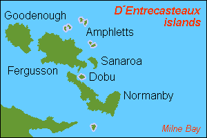
D’Entrecasteaux Islands
Image via Wikimedia Commons (author and licence on the file page).

D’Entrecasteaux Islands

Island group · 12,017 km²

D’Entrecasteaux Islands is an island group in Oceania (Melanesia), covering an estimated 12,017 km².

D'Entrecasteaux Islands (French: [dɑ̃tʁəkasto]) are situated near the eastern tip of New Guinea in the Solomon Sea in Milne Bay Province of Papua New Guinea. The group spans a distance of 160 km (99 mi), has a total land area of approximately 3,100 km2 (1,197 sq mi) and is separated from the Papua New Guinea mainland by the 30 km (19 mi) wide Ward Hunt Strait in the north and the 18 km (11 mi) wide Goschen Strait in the south. D'Entrecasteaux Islands show signs of volcanism.

Adapted from Wikipedia: D'Entrecasteaux Islands (CC BY-SA 4.0).

Feature class
Island group
Mapped extent
12,017 km²
Size rank
#136 of 445 islands
Region
Oceania
Subregion
Melanesia
Coordinates
-9.4284°, 150.5016°
Summits:
Ulawun (2,334 m), Mount Balbi (2,715 m), Takuan (2,243 m)
Ranges:
Owen Stanley Range (Oceania), New Guinea Highlands (Oceania)
Settlements:
Popondetta (258 km), Port Moresby (363 km), Lae (489 km)

View on the live map

More about D’Entrecasteaux Islands

History

The group was named for the French navigator Antoine Raymond Joseph de Bruni d'Entrecasteaux, who, in his ship the Espérance, passed through the area in 1792 while searching for his missing compatriot, Jean-François de Galaup, comte de La Pérouse. Almost a century later, in 1874, Captain John Moresby of HMS Basilisk made a running survey of the west coast of the islands and became the first European to make landfall.

From Dobu Island, local men were recruited to work in gold mines and on copra plantations. In 1891, the Methodist Church of Australia established a mission station on Dobu Island. Another mission was established in 1898 at Bwaidoga, Mud Bay, on the south coast of Goodenough Island.

Geology

Geologically the islands are largely made up of rock that probably once belonged to the northern edge of the Australian plate that was thrust deep into the Earth's crust by plate collision.

The burial of these rocks to great depths (where they also encountered correspondingly high temperatures) metamorphosed the rocks to eclogite facies: >2GPa and >700˚C. Specifically, these islands play host to the youngest known coesite-eclogite sample; CA-TIMS dating of zircons within this sample dates its formation to ~5Ma, meaning it has been exhumed from a depth of ~100 km at the remarkable rate of ~20mm/yr.

The rock at the centre of the tall domes in these islands was thus recently very deep in the Earth.

Description

The three principal islands, from northwest to southeast, are Goodenough (Nidula), then across Moresby Strait to Fergusson (Moratau), the largest of the three, and across Dawson Strait to Normanby Island (Duau).

In addition there are numerous small islands and reefs. Sanaroa and Dobu are the most significant of the smaller islands, while Sori or Wild is named for HMS Challenger's artist, John James Wild. The highest peak in the group is the 2,536 metres (8,320 ft) Mount Vineuo on Goodenough Island.

The D'Entrecasteaux Islands are volcanically active, with a number of areas of historic/geologic volcanism and active geothermal fields. Fergusson Island has three volcanic masses over 1,828 m (5,997 ft) high.

Sections adapted from Wikipedia: D'Entrecasteaux Islands (CC BY-SA 4.0).

D’Entrecasteaux Islands: Key Facts

Key facts about D’Entrecasteaux Islands
Area3,100 km²
Surrounded bySolomon Sea

Facts from Wikidata Q855297 (CC0).

Bougainville
Image via Wikimedia Commons (author and licence on the file page).

Bougainville

Island group · 8,751 km²

Bougainville is an island group in Oceania (Melanesia), covering an estimated 8,751 km².

Bougainville Island ( , ; Tok Pisin: Bogenvil) is the main island of the Autonomous Region of Bougainville, which is part of Papua New Guinea. Its land area is 9,384 km2 (3,623 sq mi). The highest point is Mount Balbi, on the main island, at 2,715 m (8,907 ft).

The much smaller Buka Island, c. 500 km2 (190 sq mi), lies to the north, across the 400–500-metre-wide (1,300–1,600 ft) Buka Strait. Even though the strait is narrow, there is no bridge across it, but there is a regular ferry service between the key settlements on either side. The main airstrip in the north is in the town of Buka. Buka has an outcropping that is 175 km (109 mi) from New Ireland. Among the large islands of Papua New Guinea, New Ireland is the closest to Buka.

Bougainville is the largest island in the Solomon Islands archipelago. It was previously the main landmass in the North Solomons, which were associated with the German Empire. Most of the islands in this archipelago (which are primarily concentrated in the southern and eastern portions of it) are part of the politically independent Solomon Islands.

Adapted from Wikipedia: Bougainville Island (CC BY-SA 4.0).

Feature class
Island group
Mapped extent
8,751 km²
Size rank
#160 of 445 islands
Region
Oceania
Subregion
Melanesia
Coordinates
-6.5147°, 155.5329°
Summits:
Takuan (2,243 m), Mount Balbi (2,715 m), Ulawun (2,334 m)
Ranges:
Owen Stanley Range (Oceania), New Guinea Highlands (Oceania)
Settlements:
Arawa (32 km), Honiara (585 km), Popondetta (841 km)

View on the live map

More about Bougainville

Geography

Bougainville is the largest island of the Solomon Islands archipelago. It is part of the Solomon Islands rain forests ecoregion. Bougainville and the nearby island of Buka are a single landmass separated by a deep 300-metre (980 ft) wide strait. The island has an area of 9,000 km2 (3,500 sq mi), and there are several active, dormant or inactive volcanoes that can rise to 2,400 m (7,900 ft). Bagana (1,750 metres [5,740 ft]) in the north central part of Bougainville is conspicuously active, spewing out gas that is visible for many kilometres. In 2013, a magnitude 6.4 earthquake was detected on the Bougainville Island; its epicenter was located 57 kilometers (35.4 miles) south of Panguna, a town on Bougainville Island.

History

During the Last Ice Age, present-day Bougainville Island was part of a single landmass known as "Greater Bougainville", which spanned from the northern tip of Buka Island to the Nggela Islands. The earliest evidence of human settlement is at Kilu Cave on Buka Island, where the earliest remains are from 26,700 to 18,100 BCE. The first settlers were Melanesian people, likely related to modern Papuans and Indigenous Australians. In the 2nd millennium BCE, Austronesian people arrived, bringing with them domesticated pigs, chickens, dogs, and obsidian tools.

The first European contact with Bougainville was in 1768, when the French explorer Louis Antoine de Bougainville arrived and named the main island after himself.

Ecology

Bougainville Island is primarily forested. Copper mining on the island by a Rio Tinto-owned mining operation in Panguna was known for their environmental impacts due to heavy metals. More recently, deforestation to feed the growing population has affected the flow of many rivers on the island. The United Nations Environment Programme has offered to facilitate the cleanup of the Panguna mine and explore reopening it with more stringent environmental standards.

Demographics

The majority of people on Bougainville are Christian, an estimated 75–80% being Roman Catholic as of 2015, and a substantial minority belonging to the United Church of Papua New Guinea and the Seventh-day Adventist Church.

There are many indigenous languages in Bougainville Province, belonging to three language families. The languages of the northern end of the island, and some scattered around the coast, belong to the Austronesian family. The languages of the north-central and southern lobes of Bougainville Island belong to the North and South Bougainville families.

The most widely spoken Austronesian language is Halia and its dialects, spoken on the island of Buka and the Selau peninsula of Northern Bougainville.

Sections adapted from Wikipedia: Bougainville Island (CC BY-SA 4.0).

Bougainville: Key Facts

Key facts about Bougainville
Area9,318 km²
Population234,280 (2011)
Highest pointMount Balbi
Surrounded byPacific Ocean

Facts from Wikidata Q201766 (CC0).

New Ireland
Image via Wikimedia Commons (author and licence on the file page).

New Ireland

Island group · 6,961 km²

New Ireland is an island group in Oceania (Melanesia), covering an estimated 6,961 km².

New Ireland (Tok Pisin: Niu Ailan), or Latangai, is a large island in Papua New Guinea, approximately 7,404 km2 (2,859 sq mi) in area with c. 120,000 people. It is named after the island of Ireland. It is the largest island of New Ireland Province, lying northeast of the island of New Britain. Both islands are part of the Bismarck Archipelago, named after Otto von Bismarck, and they are separated by Saint George's Channel.

The administrative centre of the island and of New Ireland province is the town of Kavieng located at the northern end of the island. While the island was part of German New Guinea, it was named Neumecklenburg ("New Mecklenburg").

Adapted from Wikipedia: New Ireland (island) (CC BY-SA 4.0).

Feature class
Island group
Mapped extent
6,961 km²
Size rank
#174 of 445 islands
Region
Oceania
Subregion
Melanesia
Coordinates
-4.3615°, 152.8865°
Summits:
Ulawun (2,334 m), Mount Balbi (2,715 m), Takuan (2,243 m)
Ranges:
Owen Stanley Range (Oceania), New Guinea Highlands (Oceania)
Settlements:
Arawa (362 km), Lae (704 km), Popondetta (709 km)

View on the live map

More about New Ireland

Geography

The island is part of the Bismarck Archipelago and is often described as having the shape of a musket. New Ireland is surrounded by the Bismarck Sea in the southwest and by the Pacific Ocean in the northeast.

For much of its 360 km (220 mi) in length, the island's width varies between less than 10 km (6.2 mi) to 40 km (25 mi), yet the central mountainous spine is very steep and rugged. The highest peak is Mount Taron in the Hans Meyer Range (2,340 m, 7,680 ft). Other mountain ranges are Tirpitz, Schleinitz, Verron and Rossel. The island lies between two and five degrees south of the equator. The original land cover was primarily dense rainforest.

History

The first inhabitants of the Bismarck Archipelago arrived around 33,000 years ago after sailing from what is now Papua New Guinea. Later arrivals included the Lapita people approximately 3,000 years ago. Three distinct cultural practices are characteristic of the native people of New Ireland: Kabai, Malagan and Tubuan.

In 1616 the Dutch sailors Jacob Le Maire and Willem Schouten were the first Europeans to set foot on the island, but it was only recognized as part of an island separate from New Guinea by William Dampier in 1700. Philip Carteret recognized it as separate from New Britain (then New Pomerania) in 1767, and Louis Antoine de Bougainville anchored here eleven months later, on 6 July 1768.

Ecology

The island is part of two ecoregions. The New Britain–New Ireland lowland rain forests extend from sea level to 1000 meters elevation. The New Britain-New Ireland montane rain forests cover the mountains of New Ireland above 1000 meters elevation.

Widespread deforestation and degradation of lowland rainforest is an issue on New Ireland and the other eastern islands of Papua New Guinea (New Britain, Bougainville Island) as well as on Papua New Guinea mainland. Nearly 60% of their forests are accessible to logging, and by 2002, 63% of the accessible forests had been deforested or degraded.

The island hosts 8 endemic landbirds, some of these only rarely documented scientifically.

Sections adapted from Wikipedia: New Ireland (island) (CC BY-SA 4.0).

New Ireland: Key Facts

Key facts about New Ireland
Area7,405 km²
Population100,000
Highest pointMount Taron
Surrounded byBismarck Sea

Facts from Wikidata Q215089 (CC0).

Manus
Image via Wikimedia Commons (author and licence on the file page).

Manus

Island · 1,853 km²

Manus is an island in Oceania (Melanesia), covering an estimated 1,853 km².

Manus Island is part of Manus Province in northern Papua New Guinea and is the largest of the Admiralty Islands. It is the fifth-largest island in Papua New Guinea, with an area of 2,100 km2 (810 sq mi), measuring around 100 km × 30 km (60 mi × 20 mi). Manus Island is covered in rugged jungles which can be broadly described as lowland tropical rain forest. The highest point on Manus Island is Mt. Dremsel, 718 metres (2,356 ft) above sea level at the centre of the south coast. Manus Island is volcanic in origin and probably broke through the ocean's surface in the late Miocene, 8 to 10 million years ago. The substrate of the island is either directly volcanic or from uplifted coral limestone.

Lorengau, the capital of Manus Province, is located on the island. Momote Airport, the terminal for Manus Province, is located on nearby Los Negros Island. A bridge connects Los Negros Island to Manus Island and the provincial capital of Lorengau. In the 2000 census, the whole Manus Province had a population of 50,321. The Austronesian Manus languages are spoken on the island.

Adapted from Wikipedia: Manus Island (CC BY-SA 4.0).

Feature class
Island
Mapped extent
1,853 km²
Size rank
#256 of 445 islands
Region
Oceania
Subregion
Melanesia
Coordinates
-2.0740°, 146.9618°
Summits:
Mount Wilhelm (4,509 m), Ulawun (2,334 m), Mount Balbi (2,715 m)
Ranges:
New Guinea Highlands (Oceania), Owen Stanley Range (Oceania)
Settlements:
Madang (374 km), Wewak (404 km), Goroka (479 km)

View on the live map

More about Manus

History

The first recorded sighting of Manus Island by Europeans was by Spanish explorer Álvaro de Saavedra on board the carrack Florida on 15 August 1528, while trying to return to New Spain from the Maluku Islands. Saavedra circled Manus Island, and landed possibly on Murai islet to the south west. Murai was found to be inhabited and some natives came out in canoes, attacking with bows and arrows. Three of these men were captured by the Spaniards, and were returned by Saavedra to the same island, on his second attempt to return to North America the following year. Manus Island was charted as Urays la Grande or Big Urays, which is probably a projection of Murai to signify "big Murai".

Sections adapted from Wikipedia: Manus Island (CC BY-SA 4.0).

Manus: Key Facts

Key facts about Manus
Area1,940 km²
Population33,000
Surrounded byBismarck Sea

Facts from Wikidata Q602106 (CC0).

Mussau
Image via Wikimedia Commons (author and licence on the file page).

Mussau

Island · 416 km²

Mussau is an island in Oceania (Melanesia), covering an estimated 416 km².

Mussau Island is the largest island of St Matthias Islands, Papua New Guinea, at 1°25′01″S 149°37′59″E. It is part of the New Ireland Province of Papua New Guinea. The island is a noted biodiversity hotspot with pristine primeval rainforest covering most of Mussau's hilly landscape. The island has over 243 endemic plant species as well as at least 47 native butterfly species.

Adapted from Wikipedia: Mussau Island (CC BY-SA 4.0).

Feature class
Island
Mapped extent
416 km²
Size rank
#344 of 445 islands
Region
Oceania
Subregion
Melanesia
Coordinates
-1.4666°, 149.6518°
Summits:
Ulawun (2,334 m), Mount Wilhelm (4,509 m), Mount Balbi (2,715 m)
Ranges:
New Guinea Highlands (Oceania), Owen Stanley Range (Oceania)
Settlements:
Madang (599 km), Lae (656 km), Goroka (698 km)

View on the live map

More about Mussau

Mussau: Key Facts

Key facts about Mussau
Area414 km²
Population2,900
Surrounded byBismarck Sea

Facts from Wikidata Q1589522 (CC0).

Karkar
Image via Wikimedia Commons (author and licence on the file page).

Karkar

Island · 371 km²

Karkar is an island in Oceania (Melanesia), covering an estimated 371 km².

Karkar Island is an oval-shaped volcanic island located in the Bismarck Sea, about 74 kilometres (46 mi) off the north coast of mainland Papua New Guinea in Madang Province, from which it is separated by the Isumrud Strait. The island is about 25 km (16 mi) in length and 19 km (12 mi) in width. In the centre is an active volcano with two nested calderas.

Adapted from Wikipedia: Karkar Island (CC BY-SA 4.0).

Feature class
Island
Mapped extent
371 km²
Size rank
#348 of 445 islands
Region
Oceania
Subregion
Melanesia
Coordinates
-4.6614°, 145.9647°
Summits:
Mount Wilhelm (4,509 m), Ulawun (2,334 m), Puncak Jaya (4,884 m)
Ranges:
New Guinea Highlands (Oceania), Owen Stanley Range (Oceania)
Settlements:
Madang (66 km), Goroka (171 km), Mount Hagen (235 km)

View on the live map

More about Karkar

Geography

The land is covered with the volcanic andesitic lava. The soil is very fertile and used for growing food crop and cash crop. The island is full of betel-nut, mustard plant and lime. The island is also known for the view from the mountain looking down to Madang town.

The latest eruptions on this island occurred in the 1970s. The 1974–1975 eruption produced a large volume of lava which covered almost 70% of the inner caldera's floor, while 1979 produced no lava flow, but killed two volcanologists, Robin Cooke and Elias Ravian. The volcano erupted as recently as February 26, 2013.

The population of approximately 70,000 is mostly Lutheran and Catholic and speaks the two languages Waskia and Takia. Most people also speak Tok Pisin, and English is taught in the schools.

History

The first recorded sighting by Europeans of Karkar Island was by the Spanish navigator Iñigo Órtiz de Retes on 10 August 1545 when on board of the carrack San Juan tried to return from Tidore to New Spain.

It was later visited by Willem Schouten and Jacob le Maire and called "High island". In 1643 Abel Tasman passed the island. William Dampier visited the island, probably in 1699. The volcano erupted in 1895.

During World War II, the Imperial Japanese occupied the island. The Australian 37th/52nd Battalion landed on 2 June 1944, to find that the Japanese had evacuated the island and Australian 5th Division troops landed on the island at Biu Bay and Kavilo Bay on 6 June 1944.

Sections adapted from Wikipedia: Karkar Island (CC BY-SA 4.0).

Karkar: Key Facts

Key facts about Karkar
Area362 km²
Population65,000
Surrounded byBismarck Sea

Facts from Wikidata Q720720 (CC0).

More on Papua New Guinea

Quick Answers

What is the largest island in Papua New Guinea?
New Guinea, at 785,443 km². Bismarck Archipelago is second at 534,907 km². Rankings cover the islands indexed in YearMaps.
How many islands are there in Papua New Guinea?
YearMaps lists 10 islands for Papua New Guinea. This is the number mapped in the atlas, not an official national count.