
Ports & Harbours of the Persian Gulf and the Gulf of Oman
YearMaps maps 64 harbours on the Persian Gulf and the Gulf of Oman, in 8 countries and territories. The largest by the World Port Index's harbour size are Bushehr, Bandar Abbas, Khorramshahr, Abadan, Khawr Fakkan and Abu Zaby. 4 are written up in full below, and every harbour is listed with its depths, tidal range and the largest ships it takes.
The Persian Gulf is a shallow sea, nowhere much deeper than 90 m, between Iran and the Arabian Peninsula, entered only through the Strait of Hormuz. Its pearl banks and the harbours of Hormuz, Bahrain and Basra traded with India and East Africa for millennia, and since the oil discoveries of the twentieth century its terminals have shipped a large share of the world's crude oil.
- Harbours
- 64
- Countries
- 8
- Written Up
- 4
Map of the Ports of the Persian Gulf and the Gulf of Oman
Blue dots are the harbours of the World Port Index; tap or click one to open its entry. Use the layer panel to add trade routes, rivers and historical borders.
Harbours of the Persian Gulf and the Gulf of Oman in Detail
The 4 harbours of the Persian Gulf and the Gulf of Oman with an encyclopedia article, each with its figures from the World Port Index.
Khalifa Bin Salman
Medium harbour · Bahrain
Khalifa Bin Salman Port (Arabic: ميناء خليفة بن سلمان) is a seaport located in the Hidd Industrial Area in Muharraq, Bahrain. It is the principal deep-water commercial port of Bahrain and serves as Bahrain’s main maritime gateway for containerized, general, and roll-on/roll-off cargo, playing a central role in the country’s logistics, trade, and industrial sectors.
The port is named after Khalifa bin Salman Al Khalifa, the former prime minister of Bahrain.
Adapted from Wikipedia: Khalifa Bin Salman Port (CC BY-SA 4.0).
- Harbour size
- Medium
- Channel depth
- 27.4 m
- Anchorage depth
- 27.4 m
- Cargo pier depth
- 27.4 m
- Tidal range
- 2 m
- Largest vessel
- large vessels
- Country
- Bahrain
- Province
- Bahrain
- Coordinates
- 26.2500°, 50.7500°
More about Khalifa Bin Salman
History
Khalifa Bin Salman Port was officially inaugurated in April 2009, reducing the reliance on the older Mina Salman Port as Bahrain’s primary commercial port. The development of the port formed part of Bahrain’s broader strategy to modernize its infrastructure, enhance trade competitiveness, and establish the country as a regional logistics hub in the Persian Gulf.
The port was developed through a public-private partnership and was among the first ports in the region to be operated by a global terminal operator. Since its opening, KBSP has handled the majority of Bahrain’s import and export cargo, supporting the country’s non-oil economic diversification.
Facilities
The port features modern infrastructure designed to handle large vessels and a wide range of cargo types – the port includes a deep-water container terminal with an approximately 1,800‑meter-long quay equipped with post‑Panamax ship‑to‑shore gantry cranes, enabling it to accommodate large container ships operating on regional and international routes. In addition to container handling facilities, the port has dedicated areas for general cargo, bulk and breakbulk cargo, roll‑on/roll‑off (Ro‑Ro) operations, and a passenger cruise terminal. Supporting infrastructure includes extensive warehousing and bonded storage areas, customs and inspection facilities, and advanced terminal operating systems that enhance cargo handling efficiency and security.
Location
The port sits on approximately 110 hectares of reclaimed land situated in the Hidd Industrial Area, on the northeastern coast of Bahrain, approximately 10 km from Bahrain International Airport and is connected to Persian Gulf shipping lanes. Its location provides direct access to major industrial zones, including aluminum smelters, manufacturing facilities, and logistics parks. The port is also connected by road to the King Fahd Causeway, enabling overland trade with Saudi Arabia.
Sections adapted from Wikipedia: Khalifa Bin Salman Port (CC BY-SA 4.0).

Umm Qasr
Small harbour · Iraq
Umm Qasr Port is Iraq's only deep water port, part of the city of Umm Qasr.
Iraq's second biggest port in scale of size and goods shipped, ranking behind the port of Basra, it is strategically important, located on the western edge of the al-Faw peninsula, where the mouth of the Shatt al Arab waterway enters the Persian Gulf. It is separated from the border of Kuwait by a small inlet. Prior to the Persian Gulf War, traffic between Kuwait and Iraq flowed over a bridge. The port is part of the Maritime Silk Road.
Adapted from Wikipedia: Umm Qasr Port (CC BY-SA 4.0).
- Harbour size
- Small
- Channel depth
- 34.7 m
- Anchorage depth
- 38.4 m
- Cargo pier depth
- 38.4 m
- Tidal range
- 1 m
- Largest vessel
- medium vessels
- Country
- Iraq
- Province
- Basra Governorate
- Coordinates
- 30.0200°, 47.9500°
More about Umm Qasr
History
Umm Qasr was originally a small fishing town, but was said to have been the site of Alexander the Great's landing in Mesopotamia in 325 BC. During the Second World War a temporary port was established there by the Allies to unload supplies to dispatch to the Soviet Union. It fell back into obscurity after the war, but the government of King Faisal II sought to establish a permanent port there in the 1950s.
In 1958 after the coup d'etat of the Iraqi Army known as the 14 July Revolution, the Iraqi Navy established a base there. The new regime of General Abdul-Karim Qassem undertook mass planning of the economy of Iraq, based on oil export and factory based production, which required new shipping facilities.
Sections adapted from Wikipedia: Umm Qasr Port (CC BY-SA 4.0).
Umm Qasr: Key Facts
| Established | 1964 |
|---|---|
| Operator | General Company for Ports of Iraq |
Facts from Wikidata Q7881645 (CC0).
Dammam
Small harbour · Saudi Arabia
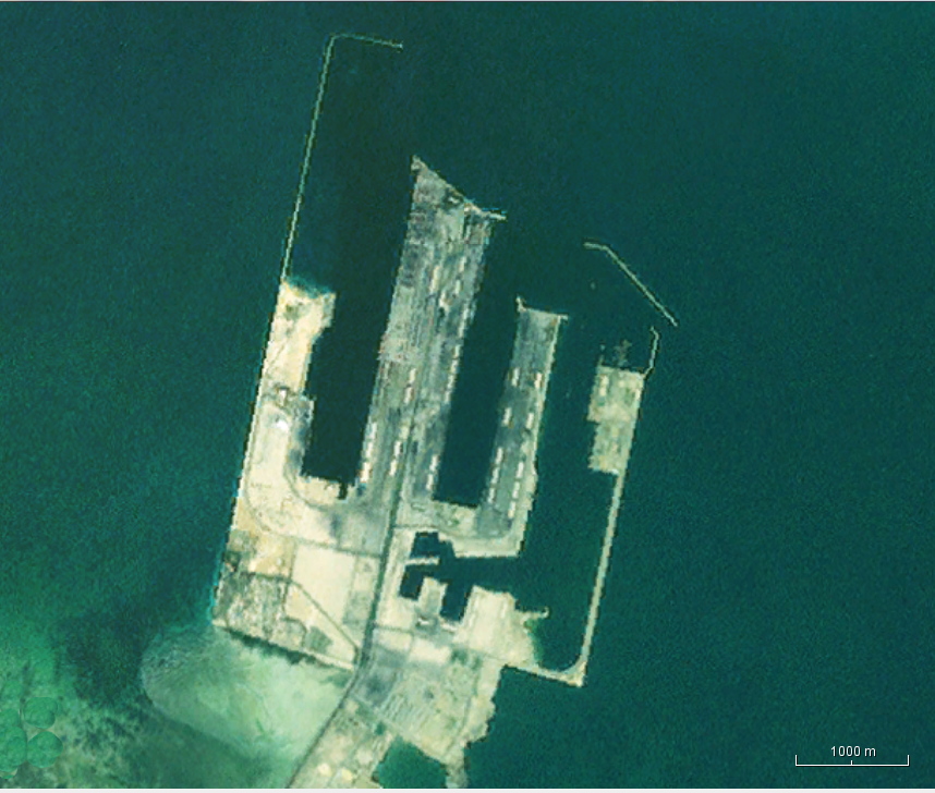
King Abdulaziz Port, also known as Dammam Port, is a port in the city of Dammam, Saudi Arabia. It is the largest port in the Persian Gulf, and the third largest and third busiest port in the Middle East and North Africa (MENA) region, after the Jeddah Islamic Port. King Abdul Aziz Port is a major export center for the oil industry, and also a key distribution center for major landlocked cities in the country, particularly the capital cities of provinces, such as Riyadh which is linked to Dammam by a railway line.
The port is part of the Maritime Silk Road that runs from the Chinese coast to the south via the southern tip of India to Mombasa, from there through the Red Sea via the Suez Canal to the Mediterranean, there to the Upper Adriatic region to the northern Italian hub of Trieste with its rail connections to Central Europe, Eastern Europe and the North Sea.
Following the discovery of large oil reserves in the Eastern Province in 1938, the small coastal village of Dammam rapidly developed into a major regional city and important seaport. It became a centre for natural gas and petroleum reserves and the commercial hub of eastern Saudi Arabia.
Adapted from Wikipedia: King Abdulaziz Port (CC BY-SA 4.0).
- Harbour size
- Small
- Channel depth
- 27.4 m
- Anchorage depth
- 27.4 m
- Cargo pier depth
- 31.1 m
- Tidal range
- 2 m
- Largest vessel
- large vessels
- Country
- Saudi Arabia
- Province
- Eastern Province
- Coordinates
- 26.5000°, 50.2000°
More about Dammam
Dammam: Key Facts
| Operator | Saudi Ports Authority |
|---|---|
| On | Persian Gulf |
Facts from Wikidata Q24950861 (CC0).
Port of Sohar
Small harbour · Oman
SOHAR Port and Freezone is a deep-sea port and adjacent free zone in the Middle East, located in Liwa, Sultanate of Oman, despite the name. With current investments exceeding $26 billion & a footprint of over 4,500 hectares, it is one of the world's fastest growing port and free zone developments and lies at the centre of global trade routes between Europe and Asia.
SOHAR Port and Freezone is managed by the Sohar Industrial Port Company (SIPC), a 50:50 joint venture between the Port of Rotterdam and the Sultanate of Oman.
The Port handles over one million tonnes of sea cargo each week and around 3,500 ships a year; it is equipped with deep-water jetties capable of handling some of the world's largest vessels, such as the Valemax class of dry bulk carriers.
Adapted from Wikipedia: SOHAR Port and Freezone (CC BY-SA 4.0).
- Harbour size
- Small
- Channel depth
- 23.8 m
- Anchorage depth
- 5.5 m
- Cargo pier depth
- 23.8 m
- Oil terminal depth
- 23.8 m
- Tidal range
- 3 m
- Country
- Oman
- Province
- Al Batinah North.
- Coordinates
- 24.5200°, 56.6300°
More about Port of Sohar
History
In 1995, Sultan Qaboos, set up a ministerial committee to develop the Port of Salalah (previously called Raysut) and establish a new port in Sohar. Informal advisory work began from 1998 to 2000 in close cooperation with the Ministry of Transport and Communication. Subsequently, the first phase of the port was developed by the Government of Oman.
In July 2002, the Government of Oman and the Port of Rotterdam signed a memorandum of understanding (MoU) to develop a concession agreement for SOHAR Port. The Royal Decree no. 80/2002 ratified the concession agreement of SOHAR Port and was issued in August of the same year. The construction of the petrochemical complex, terminal and other utilities of the port commenced in 2003.
Operations
SOHAR Port and Freezone was originally planned around three key industrial clusters, namely logistics, metals, and petrochemicals. The port has since added a fourth pillar with the launch of the SOHAR Food Cluster, complemented by the first dedicated agro bulk terminal in a region heavily dependent on food imports.
The SOHAR Port South expansion is fundamental to Oman's national focus on growing the logistics and industry sectors as part of its ongoing economic diversification efforts. This expansion aims to aid the steady growth in aggregate cargo volumes and investments at the port by delivering additional cargo capacity and attracting more business. It will add 250 hectares to the industrial port's current capacity of 2,000 hectares by January 2019.
Location
The wilaya (province) of Liwa lies in the centre of the Al Batinah North Governorate, in the North of Oman. This provides the port with a strategic location outside the Strait of Hormuz - the stretch of water providing the only passage between the Persian Gulf and the Indian Ocean, and an important means of sea transportation linking the Gulf Arab states to India, the rest of the Middle East, China and South East Asia, as well as Europe.
Sections adapted from Wikipedia: SOHAR Port and Freezone (CC BY-SA 4.0).
All Harbours of the Persian Gulf and the Gulf of Oman
64 harbours, the largest first by the index's harbour size. Channel depth and tidal range set the physical limit on which ships can call. 11 of them are recorded in the source with the city they serve.
| Harbour | Country | Size | Channel | Anchorage | Tide | Largest vessel | Map |
|---|---|---|---|---|---|---|---|
| Bushehrserves Bandar-e Bushehr | Iran | Medium | 45.7 m | — | 1 m | medium vessels | |
| Bandar Abbas | Iran | Medium | 42.1 m | 12.8 m | 2 m | medium vessels | |
| Khorramshahr | Iran | Medium | 42.1 m | 42.1 m | 3 m | medium vessels | |
| Abadan | Iran | Medium | 38.4 m | — | 1 m | medium vessels | |
| Khawr Fakkan | United Arab Emirates | Medium | 31.1 m | 5.5 m | 3 m | large vessels | |
| Abu Zabyserves Abu Dhabi | United Arab Emirates | Medium | 27.4 m | — | 2 m | large vessels | |
| Jabal Az Zannah/Ruways | United Arab Emirates | Medium | 27.4 m | 23.8 m | 5 m | large vessels | |
| Khalifa Bin Salman | Bahrain | Medium | 27.4 m | 27.4 m | 2 m | large vessels | |
| Mina Ash Shuaybah | Kuwait | Medium | 27.4 m | 16.5 m | 3 m | medium vessels | |
| Ras Laffan | Qatar | Medium | 27.4 m | 12.8 m | 2 m | medium vessels | |
| Sitrah | Bahrain | Medium | 27.4 m | 27.4 m | 2 m | medium vessels | |
| Mina al Ahmadiserves Al Ahmadi | Kuwait | Medium | 23.8 m | — | 2 m | medium vessels | |
| Ras Tannurah | Saudi Arabia | Medium | 23.8 m | 5.5 m | 2 m | large vessels | |
| Zirkuh Petroleum Port | United Arab Emirates | Medium | 12.8 m | — | 2 m | — | |
| al Basrahserves Basra | Iraq | Medium | — | — | 1 m | medium vessels | |
| al Manamahserves Manama | Bahrain | Small | 53 m | — | 2 m | large vessels | |
| Umm al Qaywayn | United Arab Emirates | Small | 38.4 m | — | 1 m | medium vessels | |
| Bandar-E Mahshahr | Iran | Small | 34.7 m | — | 4 m | medium vessels | |
| Doha | Qatar | Small | 34.7 m | — | 2 m | medium vessels | |
| Ras al Mishab | Saudi Arabia | Small | 34.7 m | 38.4 m | 2 m | large vessels | |
| Umm Qasr | Iraq | Small | 34.7 m | 38.4 m | 1 m | medium vessels | |
| Bandar-E Shahid Reajie | Iran | Small | 31.1 m | 34.7 m | 4 m | medium vessels | |
| Umm Said | Qatar | Small | 31.1 m | 34.7 m | 2 m | medium vessels | |
| al Hamriyah Lpg Terminal | United Arab Emirates | Small | 27.4 m | 23.8 m | 1 m | large vessels | |
| Dammam | Saudi Arabia | Small | 27.4 m | 27.4 m | 2 m | large vessels | |
| Fujayrah Harborserves Al Fujayrah | United Arab Emirates | Small | 27.4 m | — | 3 m | large vessels | |
| Mina Abd Allah | Kuwait | Small | 27.4 m | 20.1 m | 3 m | medium vessels | |
| Mubarraz Oil Terminal | United Arab Emirates | Small | 27.4 m | 23.8 m | 2 m | large vessels | |
| Bandar Khomeyni | Iran | Small | 23.8 m | 5.5 m | 4 m | large vessels | |
| Port of Sohar | Oman | Small | 23.8 m | 5.5 m | 3 m | — | |
| Ju Aymah Oil Terminal | Saudi Arabia | Small | 12.8 m | 5.5 m | 2 m | large vessels | |
| Ras al Khafji | Saudi Arabia | Small | 12.8 m | 27.4 m | 1 m | large vessels | |
| Zirkuh Oil Field | United Arab Emirates | Small | 12.8 m | — | 1 m | — | |
| Kharg Island Oil Terminal | Iran | Small | 5.5 m | 9.1 m | 2 m | medium vessels | |
| Sirus Oil Terminal | Iran | Small | 5.5 m | 5.5 m | 2 m | large vessels | |
| al Jazeera Port | United Arab Emirates | Small | — | 12.8 m | 1 m | — | |
| Jazireh-Ye Sirri | Iran | Small | — | 5.5 m | 2 m | medium vessels | |
| Khawr Khasab | Oman | Small | — | — | — | medium vessels | |
| Doha Harbor | Kuwait | Very Small | 53 m | — | — | — | |
| Khawr al Zubair | Iraq | Very Small | 53 m | 34.7 m | 3 m | medium vessels | |
| Khawr al Zubair Lng Terminal | Iraq | Very Small | 53 m | 34.7 m | 3 m | medium vessels | |
| Chah Baharserves Chabahar | Iran | Very Small | 49.4 m | — | 2 m | medium vessels | |
| Jazireh-Ye Hormoz | Iran | Very Small | 45.7 m | 31.1 m | — | — | |
| Ras al Ghar | Saudi Arabia | Very Small | 38.4 m | 38.4 m | — | — | |
| Khosrowabad | Iran | Very Small | 34.7 m | — | 5 m | medium vessels | |
| Mina Saqr | United Arab Emirates | Very Small | 34.7 m | 12.8 m | 2 m | medium vessels | |
| Umm An Nar | United Arab Emirates | Very Small | 34.7 m | — | 1 m | medium vessels | |
| al Jubayl | Saudi Arabia | Very Small | 27.4 m | — | 1 m | medium vessels | |
| Barkan Oil-Loading Terminal | Iran | Very Small | 20.1 m | 5.5 m | 2 m | medium vessels | |
| al-Basra Oil Terminal | Iraq | Very Small | 12.8 m | — | 4 m | large vessels | |
| Hulaylah Oil Terminal | United Arab Emirates | Very Small | 12.8 m | 5.5 m | — | medium vessels | |
| Ju Aymah Lpg Terminal | Saudi Arabia | Very Small | 12.8 m | 12.8 m | — | medium vessels | |
| Jazirat Das | United Arab Emirates | Very Small | 9.1 m | 5.5 m | 2 m | medium vessels | |
| Khawr al Amaya | Iraq | Very Small | 9.1 m | 34.7 m | 1 m | medium vessels | |
| al Rayyan Terminal | Qatar | Very Small | 5.5 m | 5.5 m | 2 m | medium vessels | |
| Fateh Oil Terminal | United Arab Emirates | Very Small | 5.5 m | 5.5 m | 2 m | large vessels | |
| Jask | Iran | Very Small | 5.5 m | 45.7 m | 6 m | — | |
| Jazirat Halul | Qatar | Very Small | 5.5 m | 9.1 m | 1 m | large vessels | |
| al Shaheen Terminal | Qatar | Very Small | — | 5.5 m | — | medium vessels | |
| Bandar Taheri Offshore Terminal | Iran | Very Small | — | 5.5 m | — | large vessels | |
| Bandar-E Pars Terminal | Iran | Very Small | — | 5.5 m | — | medium vessels | |
| Jazireh-Ye Lavan Oil Terminal | Iran | Very Small | — | 5.5 m | 2 m | medium vessels | |
| Mina Az Zawr | Kuwait | Very Small | — | 12.8 m | 3 m | medium vessels | |
| Qalhat Lng Terminal | Oman | Very Small | — | 12.8 m | 3 m | medium vessels |
Port Cities of the Persian Gulf and the Gulf of Oman
The most populous cities with a harbour of the Persian Gulf and the Gulf of Oman within 25 km. Each city is listed with its country's other cities on the country page.
- Kuwait2.06 million
Capital of Kuwait · Doha Harbor (17 km)
- Ad Damman2.05 million
Saudi Arabia · Ras Tannurah (23 km), Dammam (13 km)
- Doha1.45 million
Capital of Qatar · Doha
- Sharjah1.10 million
United Arab Emirates · al Hamriyah Lpg Terminal (13 km)
- Basra870,000
Iraq · al Basrah
- Abu Dhabi603,492
Capital of United Arab Emirates · Abu Zaby, Umm An Nar (12 km)
- Manama563,920
Capital of Bahrain · Khalifa Bin Salman (17 km), Sitrah (11 km), al Manamah
- Bandar-e-Abbas461,499
Iran · Bandar Abbas (9 km), Bandar-E Shahid Reajie (23 km), Jazireh-Ye Hormoz (21 km)
- Abadan370,180
Iran · Khorramshahr (15 km), Abadan, Khosrowabad (22 km)
- Al-Qatif368,892
Saudi Arabia · Ras Tannurah (20 km), Dammam (19 km)
- Az Aubayr262,219
Iraq · al Basrah (17 km)
- Al Jubayl237,274
Saudi Arabia · Ras al Ghar (25 km), al Jubayl
- Al Jahra194,193
Kuwait · Doha Harbor (15 km)
- Bandar-e Bushehr169,060
Iran · Bushehr
- Hawalli164,212
Kuwait · Doha Harbor (20 km)
- Ras al Khaymah160,849
United Arab Emirates · al Jazeera Port (18 km), Mina Saqr (24 km), Hulaylah Oil Terminal (21 km)
- Suhar151,349
Oman · Port of Sohar (21 km)
- Az Zahran97,446
Saudi Arabia · Dammam (24 km)
- Al Fujayrah94,163
United Arab Emirates · Fujayrah Harbor
- Sur71,152
Oman · Qalhat Lng Terminal (18 km)
- Al Ahmadi68,763
Kuwait · Mina Ash Shuaybah (10 km), Mina al Ahmadi, Mina Abd Allah (11 km)
- Chabahar65,801
Iran · Chah Bahar
- Umm al Qaywayn44,411
United Arab Emirates · Umm al Qaywayn, al Hamriyah Lpg Terminal (13 km)
Countries with Harbours on the Persian Gulf and the Gulf of Oman
More Seas and Coasts
See every sea, grouped from North America to Oceania & Antarctica, on the world ports index, or the voyages that crossed these waters on the famous sea voyages map.
Persian Gulf & Gulf of Oman: Quick Answers
- How many ports are there on the Persian Gulf and the Gulf of Oman?
- YearMaps lists 64 ports and harbours on the Persian Gulf and the Gulf of Oman, from the World Port Index of the US National Geospatial-Intelligence Agency. Small fishing harbours and private terminals outside the index are not counted.
- Which countries have ports on the Persian Gulf and the Gulf of Oman?
- Iran (18), United Arab Emirates (15), Saudi Arabia (8), Iraq (6), Qatar (6), Kuwait (5), Bahrain (3) and Oman (3).
- What are the largest ports on the Persian Gulf and the Gulf of Oman?
- By the World Port Index's harbour size, the largest are Bushehr, Bandar Abbas, Khorramshahr, Abadan, Khawr Fakkan and Abu Zaby.
- What are the main port cities on the Persian Gulf and the Gulf of Oman?
- The most populous cities with a harbour here are Kuwait (2.06 million), Ad Damman (2.05 million), Doha (1.45 million), Sharjah (1.10 million) and Basra (870,000).