
Map of Iraq
Iraq is a country in Asia with its capital at Baghdad, home to about 47.02 million people across 437,072 km². The interactive map below plots 27 cities and towns, 7 rivers, 4 lakes, 2 mountain summits, 1 major dams and 6 ports recorded for Iraq in YearMaps.
- Population
- 47.02 million
- Area
- 437,072 km²
- Capital
- Baghdad
- Continent
- Asia
Interactive Map of Iraq
Centred on Baghdad at 33.3406° N, 44.3919° E. Use the layer panel to switch on rivers, dams, ports, peaks and historical borders.
Wonders & Great Monuments of Iraq
Great Ziggurat of Ur and Hanging Gardens of Babylon are marked on the map above. Click a pin or use "Show on map" to fly to each one.

Great Ziggurat of Ur
Neo-Sumerian Empire (Ur-Nammu) · Bronze Age
The Ziggurat (or Great Ziggurat) of Ur (Sumerian: 𒂍𒋼𒅎𒅍 é-temen-ní-gùru "Etemenniguru", meaning "house whose foundation creates terror") is a Neo-Sumerian ziggurat in what was the city of Ur near Nasiriyah, in present-day Dhi Qar Province, Iraq. The structure was built during the Early Bronze Age (21st century BC) by King Ur-Nammu of the Third Dynasty of Ur. It had crumbled to ruins by the 6th century BC of the Neo-Babylonian period, when it was restored by King Nabonidus.
Its remains were excavated in the 1920s and 1930s by international teams led by Sir Leonard Woolley. Under Saddam Hussein in the 1980s, they were encased by a partial reconstruction of the façade and the monumental staircase. Today, Ur Tourist City is being developed adjacent to the site to serve Christian pilgrims and tourists, based on later religious traditions that identify a nearby complex as the home of the patriarch Abraham. The Ziggurat of Ur is the best-preserved of those known from Mesopotamia, besides the ziggurat of Dur Untash (Chogha Zanbil). It is one of three well-preserved structures of the Neo-Sumerian city of Ur, along with the Royal Mausolea and the Palace of Ur-Nammu (the E-hursag).
Adapted from Wikipedia: Ziggurat of Ur (CC BY-SA 4.0).
- Built by
- Neo-Sumerian Empire (Ur-Nammu)
- Built
- 2100 BCE
- Era
- Bronze Age
- Type
- Mesopotamian Temple
- Status
- UNESCO World Heritage Site (Ahwar of Southern Iraq)
- Coordinates
- 30.9628° N, 46.1039° E
Architectural Significance
A solid mud-brick core faced with baked bricks set in bitumen, with weep holes to drain the core and three converging stairways rising to the shrine of Nanna.
Photos of Great Ziggurat of Ur

en:User:Hardnfast · CC BY 3.0 
William Loftus · Public domain

.jpg)
History & architecture of Great Ziggurat of Ur
Excavation and preservation
The remains of the ziggurat were rediscovered by William Loftus in 1850. The first excavations at the site were conducted by John Taylor (mistakenly credited as "J. E. Taylor") in the 1850s, leading to the identification of the site as Ur.
After World War I, preliminary excavations were performed by Reginald Thompson and Henry Hall. The site was extensively excavated in the 1920s by Sir Leonard Woolley by appointment of the University Museum of the University of Pennsylvania and the British Museum in the period of 1922 to 1934.
The remains of the ziggurat consist of a three-layered solid mass of mud brick faced with burnt bricks set in bitumen. The lowest layer corresponds to the original construction of Ur-Nammu, while the two upper layers are part of the Neo-Babylonian restorations. The façade of the lowest level and the monumental staircase were rebuilt under the orders of Saddam Hussein.
Sections adapted from Wikipedia: Ziggurat of Ur (CC BY-SA 4.0).

Hanging Gardens of Babylon
Neo-Babylonian Empire (Nebuchadnezzar II) · Iron Age
The Hanging Gardens of Babylon were one of the Seven Wonders of the Ancient World listed by Hellenic culture. They were described as a remarkable feat of engineering with an ascending series of tiered gardens containing a wide variety of trees, shrubs, and vines, resembling a large green mountain constructed of mud bricks. It was said to have been built in the ancient city of Babylon, near present-day Hillah, Babil province, in Iraq. The Hanging Gardens' name is derived from the Greek word κρεμαστός (kremastós, lit. 'overhanging'), which has a broader meaning than the modern English word "hanging" and refers to trees being planted on a raised structure such as a terrace.
According to one legend, the Hanging Gardens were built alongside a grand palace known as The Marvel of Mankind, by the Neo-Babylonian King Nebuchadnezzar II (who ruled between 605 and 562 BC), for his Median wife, Queen Amytis, because she missed the green hills and valleys of her homeland. This was attested to by the Babylonian priest Berossus, writing in about 290 BC, a description that was later quoted by Josephus. The construction of the Hanging Gardens has also been attributed to the legendary queen Semiramis and they have been called the Hanging Gardens of Semiramis as an alternative name.
The Hanging Gardens are the only one of the Seven Wonders whose location has not been definitively established. No extant Babylonian texts mention the gardens and no definitive archaeological evidence has been found in Babylon. Three theories have been suggested to account for this: first, that the gardens were purely mythical, and the descriptions found in ancient Greek and Roman writings (including those of Strabo, Diodorus Siculus and Quintus Curtius Rufus) represented a romantic ideal of an eastern garden; second, that they existed in Babylon but were destroyed sometime around the first century AD; and third, that the legend refers to a well-documented garden that the Assyrian King Sennacherib (704–681 BC) built in his capital city of Nineveh on the River Tigris, near the modern city of Mosul.
Adapted from Wikipedia: Hanging Gardens of Babylon (CC BY-SA 4.0).
- Built by
- Neo-Babylonian Empire (Nebuchadnezzar II)
- Built
- 600 BCE
- Era
- Iron Age
- Type
- Ancient Wonder
- Status
- UNESCO World Heritage Site (Babylon)
- Coordinates
- 32.5364° N, 44.4209° E
Architectural Significance
Described by Greek writers as vaulted terraces planted with trees and watered by screw or chain-pump irrigation lifting water from the Euphrates.
Photos of Hanging Gardens of Babylon

Aziz1005 · CC BY-SA 3.0

History & architecture of Hanging Gardens of Babylon
Descriptions in classical literature
There are five principal writers whose descriptions of Babylon exist in some form today. These writers concern themselves with the size of the Hanging Gardens, their overall design and means of irrigation, and why they were built.
Josephus (c. 37–100 AD) quotes a description of the gardens by Berossus, a Babylonian priest of Marduk, whose writing c. 290 BC is the earliest known mention of the gardens. Berossus described the reign of Nebuchadnezzar II and is the only source to credit that king with the construction of the Hanging Gardens.
In this palace he erected very high walls, supported by stone pillars; and by planting what was called a pensile paradise, and replenishing it with all sorts of trees, he rendered the prospect an exact resemblance of a mountainous country. This he did to gratify his queen, because she had been brought up in Media, and was fond of a mountainous situation.
Sections adapted from Wikipedia: Hanging Gardens of Babylon (CC BY-SA 4.0).
About Iraq
Iraq, officially the Republic of Iraq, is a country in West Asia. Located within the Middle East, it is bordered by Saudi Arabia to the south, Turkey to the north, Iran to the east, the Persian Gulf and Kuwait to the southeast, Jordan to the southwest, and Syria to the west. The country covers an area of 438,317 square kilometres (169,235 sq mi) and has a population of over 46 million, making it the 58th largest country by area and the 31st most populous in the world. Baghdad, home to over 8 million people, is the capital city and the largest in the country.
Starting in the 6th millennium BC, the fertile plains between Iraq's Tigris and Euphrates rivers, referred to as Mesopotamia, fostered the rise of early cities, civilisations, and empires including Sumer, Akkad, Babylonia, and Assyria. Known as the cradle of civilisation, Mesopotamia saw the invention of astrology, mathematics, navigation, timekeeping, writing systems, the wheel, the sailboat, a calendar, and a law code. After the Arab conquest of Mesopotamia in the 7th century, Iraq became the metropole of the Abbasid Caliphate with Baghdad emerging as a global cultural and intellectual hub during the Islamic Golden Age, home to institutions such as the House of Wisdom. Following Baghdad's destruction by the Mongols in 1258, Iraq came under successive empires, and from the 16th until the 20th century, it was governed within the Ottoman system as a defined region known administratively as Ottoman Iraq.
Since independence in 1932 after the defeat of the Ottoman Empire in World War I, Iraq has experienced spells of significant economic and military growth alongside periods of instability and conflict. Iraq emerged as a hashemite monarchy after centuries of Ottoman rule and a period under British administration. In 1958, a military coup led by Abdul Karim Qasim overthrew the monarchy and established a republic. Later, the Ba'ath Party took power in 1968, establishing a one-party state under Ahmed Hassan al-Bakr and later Saddam Hussein, who presided over war against Iran from 1980 to 1988 and then invaded Kuwait in 1990. In 2003, U.S.-led coalition forces invaded and occupied Iraq, overthrowing the government and triggering an insurgency and sectarian violence during the Iraq War, which ended in 2011. From 2013 to 2017, Iraq faced another major conflict with the rise and defeat of the Islamic State. Today post-war conflict continues at a lower scale, hampering stability alongside the influence of Iran. However, recently Iraq has begun to rein in Iranian influence and advance its own state authority.
Summary adapted from Wikipedia: Iraq (CC BY-SA 4.0).

Geography and Climate of Iraq
Formerly part of the Ottoman Empire, Iraq was occupied by the United Kingdom during World War I and was declared a League of Nations mandate under UK administration in 1920. Iraq attained its independence as a kingdom in 1932. It was proclaimed a republic in 1958 after a coup overthrew the monarchy, but in actuality, a series of strongmen ruled the country until 2003. The last was SADDAM Hussein, from 1979 to 2003. Territorial disputes with Iran led to an inconclusive and costly war from 1980 to 1988. In 1990, Iraq seized Kuwait but was expelled by US-led UN coalition forces during the two-month-long Gulf War of 1991. After Iraq's expulsion, the UN Security Council (UNSC) required Iraq to scrap all weapons of mass destruction and long-range missiles and to allow UN verification inspections. Continued Iraqi noncompliance with UNSC resolutions led to the Second Gulf War in 2003, when US-led forces ousted the SADDAM regime. In 2005, Iraqis approved a constitution in a national referendum and elected a 275-member Council of Representatives (COR). The COR approved most of the cabinet ministers, marking the transition to Iraq's first constitutional government in nearly a half-century. Iraq's constitution also established the Kurdistan Regional Government (KRG), a semi-autonomous region that administers the governorates of Erbil, Dahuk, and As Sulaymaniyah. Iraq has held four national legislative elections since 2006, most recently in 2021. The COR approved Mohammad Shia' al-SUDANI as prime minister in 2022. Iraq has repeatedly postponed elections for provincial councils -- last held in 2013 -- and since 2019, the prime minister has had the authority to appoint governors rather than provincial councils. Between 2014 and 2017, Iraq fought a military campaign against the Islamic State of Iraq and ash-Sham (ISIS) to recapture territory the group seized in 2014. In 2017, then-Prime Minister Haydar al-ABADI publicly declared victory against ISIS, although military operations against the group continue in rural areas. Also in 2017, Baghdad forcefully seized disputed territories across central and northern Iraq from the KRG, after a non-binding Kurdish independence referendum.
- Location
- Middle East, bordering the Persian Gulf, between Iran and Kuwait.
- Climate
- Mostly desert; mild to cool winters with dry, hot, cloudless summers; northern mountainous regions along Iranian and Turkish borders experience cold winters with occasionally heavy snows that melt in early spring, sometimes causing extensive flooding in central and southern Iraq.
- Terrain
- Mostly broad plains; reedy marshes along Iranian border in south with large flooded areas; mountains along borders with Iran and Turkey.
- Highest point
- Cheekha Dar (Kurdish for "Black Tent") 3,611 m.
- Lowest point
- Persian Gulf 0 m.
- Coastline
- 58 km.
- Land borders
- Total: 3,809 km; border countries: Iran 1,599 km; Jordan 179 km; Kuwait 254 km; Saudi Arabia 811 km; Syria 599 km; Turkey 367 km.
- Major rivers
- Euphrates river mouth (shared with Turkey[s], Syria, and Iran) - 3,596 km; Tigris river mouth (shared with Turkey[s], Syria, and Iran) - 1,950 km; the Tigris and Euphrates join to form the Shatt al Arab note: [s] after country name indicates river source; [m] after country name indicates river mouth.
- Major lakes
- Fresh water lake(s): Lake Hammar - 1,940 sq km.
- Natural resources
- Petroleum, natural gas, phosphates, sulfur.
- Land use
- Agricultural land: 21.8% (2023 est.); arable land: 11.4% (2023 est.); permanent crops: 1.2% (2023 est.); permanent pasture: 9.2% (2023 est.); forest: 1.6% (2023 est.); other: 76.5% (2023 est.)
- Natural hazards
- Dust storms; sandstorms; floods.
- Geographic note
- Strategic location on Shatt al Arab waterway and at the head of the Persian Gulf.
- Languages
- Arabic (official), Kurdish (official); Turkmen (a Turkish dialect) and Syriac (Neo-Aramaic) are recognized as official languages where native speakers of these languages are present.
- Religions
- Muslim (official) 95-98% (Shia 61-64%, Sunni 29-34%), Christian 1% (includes Catholic, Orthodox, Protestant, Assyrian Church of the East), other 1-4% (2015 est.)
- Ethnic groups
- Arab 75-80%, Kurdish 15-20%, other 5% (includes Turkmen, Yezidi, Shabak, Kaka'i, Bedouin, Romani, Assyrian, Circassian, Sabaean-Mandaean, Persian)
- Economy
- Highly oil-dependent Middle Eastern economy; fiscal sustainability subject to fluctuation in oil prices; rising public confidence in economic conditions; import-dependent for most sectors; persistent challenges of corruption, informal markets, banking access, and political fragility.
From the CIA World Factbook (public domain), archived edition of 2026-01-22. The Factbook is no longer updated, so figures reflect that edition.
Iraq in Numbers
- Population
- 47.02 million
- GDP
- US$254.4 billion
- GDP per person
- US$5,410
- Life expectancy
- 72.4 years
- Population growth
- 2.10% a year
- Population density
- 106 per km²
- Urban population
- 69.9%
- Surface area
- 435,050 km²
- Forest cover
- 1.6%
- Arable land
- 11.3%
- Access to electricity
- 100.0%
- Internet users
- 81.5%
Indicators from World Bank Open Data (CC BY 4.0). The year under each figure is its reference year.
Iraq in Depth
History
Iraq largely coincides with the ancient region of Mesopotamia, often referred to as the cradle of civilisation. The history of Mesopotamia extends back to the Lower Paleolithic period, with significant developments continuing through the establishment of the Caliphate in the late 7th century AD, after which the region became known as Iraq.
Within its borders lies the ancient land of Sumer, which emerged between 6000 and 5000 BC during the Neolithic Ubaid period. Sumer is recognised as the world's earliest civilisation, marking the beginning of urban development, written language, and monumental architecture. Sumer also had advanced canal systems.
Geography
Iraq lies between latitudes 29° and 38° N, and longitudes 39° and 49° E (a small area lies west of 39°). Spanning 437,072 km2 (168,754 mi2), it is the 58th-largest country in the world.
It has a coastline measuring 58 km (36 miles) on the northern Persian Gulf. Further north, but below the main headwaters only, the country easily encompasses the Mesopotamian Alluvial Plain. Two major rivers, the Tigris and Euphrates, run south through Iraq and into the Shatt al-Arab, thence the Persian Gulf. Broadly flanking this estuary (known as arvandrūd: اروندرود among Iranians) are marshlands, semi-agricultural. Flanking and between the two major rivers are fertile alluvial plains, as the rivers carry about 60,000,000 m3 (78,477,037 cu yd) of silt annually to the delta.
Economy
According to the International Fund for Agricultural Development, Iraq is an oil-rich upper-middle-income country. Iraq's economy is dominated by the oil sector, which has traditionally provided about 95% of foreign exchange earnings. The lack of development in other sectors has resulted in 18%–30% unemployed and a per capita GDP of $4,812. Public sector employment accounted for nearly 60% of full-time employment in 2011. The oil export industry, which dominates the Iraqi economy, generates little employment. Currently only a modest percentage of women (the highest estimate for 2011 was 22%) participate in the labour force. The official currency in Iraq is the Iraqi dinar.
Demographics
The 2021 estimate of the total Iraqi population is 43,533,592. Iraq's population was estimated to be 2 million in 1878. In 2013 Iraq's population reached 35 million amid a post-war population boom. It is the most populous country in the Arabian Plate. Iraq is made up of three former administrative divisions (vilayets) of the Ottoman Empire — Mosul, Basra and Baghdad — which were designated as concentration of different ethnic groups.
Iraq's native population is predominantly Arab, but also includes other ethnic groups such as Kurds, Turkmens, Assyrians, Yazidis, Shabaks, Armenians, Mandaeans, Circassians, and Kawliya.
Sections adapted from Wikipedia: Iraq (CC BY-SA 4.0).
Iraq: Key Facts
| Currency | Iraqi dinar |
|---|---|
| Official languages | Arabic, Kurdish language |
| Head of state | Nizar Amidi |
| Head of government | Muhammad Shia' al-Sudani |
| Form of government | federal republic, federation |
| Calling code | +964 |
| Internet domain | .iq |
| Highest point | Cheekha Dar |
| Established | 1932 |
Facts from Wikidata Q796 (CC0).
History of Iraq: Empires and States
The atlas records 42 polities whose mapped territory included part of Iraq, from Sumerian City-States in 3400 BCE to 2024 CE. They are listed in the order they first appear.
| Polity | Period here | Extent |
|---|---|---|
| Sumerian City-States | 3400–1761 BCE | A large part |
| Akkadian Empire | 2300–2101 BCE | Most |
| Gutian Dynasty | 2100–2001 BCE | A small part |
| Elam | 2000–1101 BCE | A large part |
| Assyria | 1800–901 BCE | Nearly all |
| Babylonia | 1800–601 BCE | Most |
| Neo-Assyrian Empire | 900–601 BCE | Nearly all |
| Assyrian Egypt | 650–616 BCE | Nearly all |
| Neo-Babylonian Empire | 600–531 BCE | Most |
| Achaemenid Persian Empire | 550–330 BCE | Nearly all |
| Achaemenid Empire | 550–327 BCE | Nearly all |
| The Macedonian Empire of Alexander | 323–302 BCE | Nearly all |
| Seleucid Empire | 318–127 BCE | Nearly all |
| Parthian Empire | 144 BCE – 237 CE | Nearly all |
| The Roman Empire | 117–286 CE | Nearly all |
| The Sasanian Empire | 238–637 CE | Nearly all |
| Rashidun Caliphate | 634–665 CE | Nearly all |
| The Umayyad Caliphate | 666–750 CE | Nearly all |
| The Abbasid Caliphate | 750–1259 CE | Nearly all |
| Hamdanid Emirates | 936–1125 CE | A large part |
| Abbasid Caliphate/Buyid Dynasty | 947–969 CE | Most |
| Buyid Dynasty | 970–1055 CE | Nearly all |
| Great Seljuk Empire | 1056–1201 CE | Nearly all |
| Zengid dynasty | 1139–1259 CE | A large part |
| Ayyubid Sultanate | 1192–1201 CE | A large part |
| The Mongol Empire | 1260–1343 CE | Nearly all |
| Ilkhanate | 1294–1343 CE | Nearly all |
| Jalayirid Sultanate | 1344–1401 CE | Most |
| Qara Qoyunlu | 1375–1467 CE | Most |
| Timurid Empire | 1402–1414 CE | Nearly all |
| Vassalage of Qara Qoyunlu to Timurid Empire | 1407–1467 CE | Nearly all |
| Hashemite Arab Federation | 1415–1439 CE | A large part |
| Aq Qoyunlu | 1440–1511 CE | Nearly all |
| Safavid Dynasty | 1507–1639 CE | Nearly all |
| The Ottoman Empire | 1534–1919 CE | Nearly all |
| British Colonial Empire | 1915–1946 CE | Nearly all |
| The British Empire | 1915–1946 CE | Nearly all |
| British Africa | 1919–1945 CE | Nearly all |
| Kingdom of Iraq | 1932–1957 CE | Nearly all |
| Iraqi Republic | 1960–2005 CE | Nearly all |
| United States of America | 2006–2023 CE | Nearly all |
| Republic of Iraq | 2014–2024 CE | Nearly all |
Historical Maps of Iraq
Iraq on the world map in each year one of these states held it:
Derived by testing mapped cities against dated territorial polygons. Dates are when the polygons cover this place, not the polity's whole lifespan, and polities absent from the source dataset are not listed.
Visiting Iraq
Iraq (Arabic: العراق Al-Irāq, Kurdish: عێراق Êraq) is a republic in the Middle East. It has an extremely rich history and culture that is still visible today, although accessing it may pose some challenges to visitors. It was once host to the region of ancient Mesopotamia, often called the "cradle of civilisation". After the rise of Islam, Baghdad became a center of learning and the arts during the Islamic Golden Age. Its holy cities of Najaf and Karbala now accept millions of pilgrims per year from throughout the Middle East.
Iraq is a melting pot of different cultures, with the Arabs being the largest ethnic group. Other prominent ethnic groups include the Kurds, Armenians, Assyrians, and Turkmens. And while Islam is the state religion, there are also various minority religions still actively practiced in the country. Most Iraqis are Shia Muslims, just like their Iranian counterparts.
The country has been in a state of turmoil since the 1980s. The government is dysfunctional, and the country suffers from a plethora of problems such as corruption, terrorism, and poverty.
Travel notes adapted from Wikivoyage: Iraq (CC BY-SA 4.0).
Largest Cities in Iraq
27 cities recorded. Ranked by metropolitan population. A port city's harbour is written up on the page of its sea.
| # | Name | Population | Region | Role |
|---|---|---|---|---|
| 1 | Baghdad | 5.05 million | Baghdad | National capital |
| 2 | Mosul | 1.32 million | Ninawa | Admin-1 capital |
| 3 | Dahuk | 986,000 | Dihok | Admin-1 capital |
| 4 | Irbil | 926,000 | Arbil | Admin-1 capital |
| 5 | Basra | 870,000 | Al-Basrah | Admin-1 capital |
| 6 | As Sulaymaniyah | 723,170 | As-Sulaymaniyah | Admin-1 capital |
| 7 | An Najaf | 665,552 | An-Najaf | Admin-1 capital |
| 8 | Kirkuk | 601,433 | At-Ta'mim | Admin-1 capital |
| 9 | Al Hillah | 594,605 | Babil | Admin-1 capital |
| 10 | Karbala | 510,692 | Karbala' | Admin-1 capital |
| 11 | An Nasiriyah | 451,547 | Dhi-Qar | Admin-1 capital |
| 12 | Ad Diwaniyah | 358,408 | Al-Qadisiyah | Admin-1 capital |
| 13 | Al Amarah | 345,007 | Maysan | Admin-1 capital |
| 14 | Al Kut | 321,521 | Wasit | Admin-1 capital |
| 15 | Baqubah | 299,479 | Diyala | Admin-1 capital |
| 16 | Ar Ramadi | 295,121 | Al-Anbar | Admin-1 capital |
| 17 | Az Aubayr | 262,219 | Al-Basrah | Populated place |
| 18 | Al Fallujah | 231,819 | Al-Anbar | Populated place |
| 19 | As Samawah | 174,978 | Al-Muthannia | Admin-1 capital |
| 20 | Ash Shatrah | 161,949 | Dhi-Qar | Populated place |
| 21 | Samarra | 158,508 | Sala ad-Din | Admin-1 capital |
| 22 | Tall Afar | 144,465 | Ninawa | Populated place |
| 23 | Zakho | 134,863 | Dihok | Populated place |
| 24 | Al Musayyib | 76,454 | Babil | Populated place |
| 25 | Tikrit | 56,591 | Sala ad-Din | Populated place |
The other 2 (population, region, role)
- Mandali · 29,785 · Diyala · Populated place
- Ar Rutbah · 22,370 · Al-Anbar · Populated place
Highest Mountains in Iraq
2 mountains recorded. Ranked by summit elevation above sea level. A summit on a border is listed under both countries.
| # | Name | Elevation | Feet | Region |
|---|---|---|---|---|
| 1 | Cheekha Dar | 3,611 m | 11,847 ft | Asia |
| 2 | Kuh-e Haji Ebrahim | 3,587 m | 11,768 ft | Asia |

Cheekha Dar
Mountain · 3,611 m
Cheekha Dar is a mountain rising to 3,611 metres (11,847 ft) in Iraq and Iran, in the Asia region. The summit stands on the border between them. From PeakBagger.com, with kind permission..
Cheekha Dar (Kurdish: Çîxî Derê, Sorani Kurdish: چیخی دەرێ), which means Black Tent, is the local Kurdish name for the mountain, located in Kurdistan Region of Iraq, currently thought to be the highest in Iraq. It is claimed to be 3,611 m (11,847 ft) high in the CIA World Factbook. It is 6 km (3.7 mi) north of the village of Gundah Zhur and is on the border with Iran.
Adapted from Wikipedia: Cheekha Dar (CC BY-SA 4.0).
- Elevation
- 3,611 m (11,847 ft)
- Global rank
- #162 of 641 indexed
- Region
- Asia (#71)
- Countries
- Iraq, Iran
- Coordinates
- 36.7800°, 44.9199°
Of the 641 named summits indexed in YearMaps, Cheekha Dar ranks #162 by elevation, below Gugu (3,626 m) and above Kuh-e Haji Ebrahim (3,587 m).
- Ranges:
- Lesser Caucasus (Asia), Pontic Mountains (Asia)
- Neighbouring summits:
- Kuh-e Haji Ebrahim (3,587 m)
- Settlements below:
- Irbil (105 km), As Sulaymaniyah (143 km), Kirkuk (153 km)
More about Cheekha Dar
History
It was climbed in November 2004 by English explorer Ginge Fullen, who recorded a GPS reading of 3,628 meters at the coordinates in the adjacent table. The location is consistent with SRTM and Russian topographic mapping, although these sources are more consistent with the CIA height.
The first reported winter ascent was by Jonathan Beswick and Matthew DuPuy on March 18, 2011. The expedition GPS confirmed 3,611 m (11,847 ft). There is a danger of land mines in the area on approach between Hamilton Road and the village of Gundah Zhur. Some fields are marked by red, triangular signs with skull and crossbones. It is possible to find Kurdish military escorts through this area in the town of Choman.
Sections adapted from Wikipedia: Cheekha Dar (CC BY-SA 4.0).
Cheekha Dar: Key Facts
| Topographic prominence | 1,575 m |
|---|---|
| Mountain range | Zagros Mountains |
Facts from Wikidata Q1068860 (CC0).
Kuh-e Haji Ebrahim
Mountain · 3,587 m
Kuh-e Haji Ebrahim is a mountain rising to 3,587 metres (11,768 ft) in Iraq, in the Asia region.
Kuh-e Haji Ebrahim (Kurdish: شاخی حاجی ئیبراهیم, Persian: کوه حاجی ابراهیم) is a mountain of the Qandil Mountains, a subrange of the Zagros Mountains. The peak is located in Borders of Parts of Kurdistan in western Asia.
Haji Ebrahim has an elevation of 3,587 metres (11,768 ft) and sits on the international Greater Kurdistan.
Adapted from Wikipedia: Kuh-e Haji Ebrahim (CC BY-SA 4.0).
- Elevation
- 3,587 m (11,768 ft)
- Global rank
- #163 of 641 indexed
- Region
- Asia (#72)
- Country
- Iraq
- Coordinates
- 36.5453°, 45.0062°
Of the 641 named summits indexed in YearMaps, Kuh-e Haji Ebrahim ranks #163 by elevation, below Cheekha Dar (3,611 m) and above Monte Tronador (3,554 m).
- Ranges:
- Lesser Caucasus (Asia), Pontic Mountains (Asia)
- Neighbouring summits:
- Cheekha Dar (3,611 m), Mount Ararat (5,137 m), Kackar Dagi (3,931 m)
More about Kuh-e Haji Ebrahim
Kuh-e Haji Ebrahim: Key Facts
| Topographic prominence | 1,747 m |
|---|---|
| Mountain range | Zagros Mountains |
Facts from Wikidata Q6442085 (CC0).
Major Dams in Iraq
1 dam recorded. Ranked by structural height.
| # | Name | Height | River | Capacity | Completed |
|---|---|---|---|---|---|
| 1 | Mosul Dam (Saddam Dam) | 113 m | Tigris | 1,052 MW | 1986 |
Largest Lakes in Iraq
4 lakes recorded. Ranked by mapped surface area. A lake on a border is listed under each country it lies in, with the area of the whole lake.
| # | Name | Surface Area | Type |
|---|---|---|---|
| 1 | Buhayrat ath Tharthar | 1,548 km² | Reservoir |
| 2 | Lake Razazah | 1,426 km² | Alkaline Lake |
| 3 | Lake Hammar | 929 km² | Alkaline Lake |
| 4 | Lake Habbaniyah | 388 km² | Reservoir |

Buhayrat ath Tharthar
Reservoir · 1,548 km²
Buhayrat ath Tharthar is an artificial reservoir in Iraq, with a mapped surface area of about 1,548 km². It exists because of a dam rather than natural drainage. Largest lake in Iraq.
Lake Tharthar (also Therthar), and known in Iraq as Buhayrat ath-Tharthar (Arabic: بحيرة الثرثار), is an artificial lake created in 1956, situated 100 kilometers (62 mi) northwest of Baghdad between the Tigris and the Euphrates rivers.
Adapted from Wikipedia: Lake Tharthar (CC BY-SA 4.0).
- Surface area
- 1,548 km²
- Area rank
- #131 of 756 indexed
- Type
- Reservoir
- Country
- Iraq
- Coordinates
- 33.8960°, 43.3013°
Among the 756 water bodies with a mapped extent in YearMaps, Buhayrat ath Tharthar ranks #131 by surface area, after Har Us Nuur (1,549 km²) and ahead of Cree Lake (1,547 km²). Areas are computed from the mapped outline and are approximate.
- Settlements on the shore:
- Ar Ramadi (53 km), Samarra (62 km), Al Fallujah (75 km)
- Other water nearby:
- Lake Habbaniyah (388 km²), Lake Razazah (1,426 km²)
More about Buhayrat ath Tharthar
History
In 1956, the southern part of the Tharthar depression was turned into an artificial reservoir to collect floodwaters of the Tigris River. The water flows via an artificial inlet canal, named Tharthar Canal. The canal diverts the excess water, by means of a regulator, the Samarra Barrage. It merges with the lake in its southeastern bank.
The lake has an artificial outlet called Taksim Tharthar Canal, which drains to the Euphrates River directly. The canal, after 28 km (17.4 mi) from its outlet, bifurcates to another canal called "Dhira'a Dijla" (Arm of Tigris) that returns water back to the Tigris River.
Lake Tharthar was the site of a joint American-Iraqi raid in 2005 against an insurgent training base in the region.
Description
The Tharthar depression was formed during the Holocene age, mainly by karstification, due to dissolving of gypsum rocks of the Fatha Formation nearby. Tharthar covers roughly 2,050 km2 (790 sq mi) and flows from the central and eastern parts of the Sinjar Mountains and adjacent hills, with a floor of –3m above sea level. The maximum length and width of the depression are 120 and 48 km, respectively. The eastern rim of the depression is higher than the western one; the heights of both rims are 90 metres (300 ft) and 75 metres (246 ft), respectively.
The main purpose of the Tharthar Lake is to collect excess water of the Tigris River during flood seasons and to recharge water to the Tigris and Euphrates Rivers during dry seasons, when there is shortage of water in both rivers.
Sections adapted from Wikipedia: Lake Tharthar (CC BY-SA 4.0).
Buhayrat ath Tharthar: Key Facts
| Surface area | 2,710 km² |
|---|---|
| Maximum depth | 65 m |
Facts from Wikidata Q1640519 (CC0).
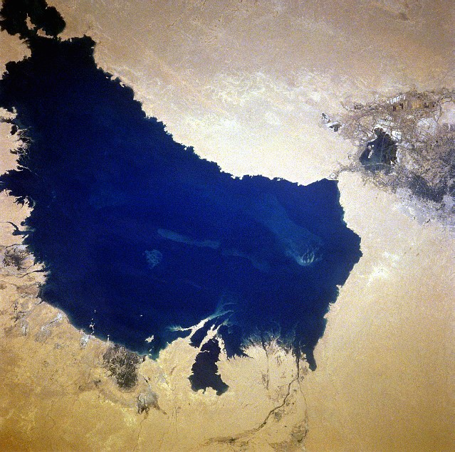
Lake Razazah
Alkaline Lake · 1,426 km²
Lake Razazah is a alkaline lake in Iraq, with a mapped surface area of about 1,426 km².
Lake Razzaza (Arabic: البحيرة الرزازة, romanized: Buhairat Al-Razzaza, lit. 'Lake of spray'), also known as Lake Milh (Arabic: بحيرة الملح, romanized: Buhairat Al-Milh, lit. 'Lake of Salt'), is an artificial lake located a few miles west of Karbala, Iraq (32°41′N 43°40′E). The lake is located in a depression into which excess water from Lake Habbaniyah, which comes from the Euphrates River, is diverted through a controlled escape channel or canal. The lake is listed as a wetland of international importance. The lake is rather shallow and the water level changes seasonally. Due to its salt content and changing water level, this largest freshwater lake in Iraq has lost its important stock of fish species and only a few recreational areas exist around the lake.
Adapted from Wikipedia: Lake Milh (CC BY-SA 4.0).
- Surface area
- 1,426 km²
- Area rank
- #144 of 756 indexed
- Type
- Alkaline Lake
- Country
- Iraq
- Coordinates
- 32.7338°, 43.5891°
Among the 756 water bodies with a mapped extent in YearMaps, Lake Razazah ranks #144 by surface area, after Bariri (1,435 km²) and ahead of Tengiz Köli (1,424 km²). Areas are computed from the mapped outline and are approximate.
- Settlements on the shore:
- Karbala (43 km), Al Musayyib (66 km), Al Fallujah (70 km)
- Other water nearby:
- Lake Habbaniyah (388 km²), Buhayrat ath Tharthar (1,548 km²)
More about Lake Razazah
Geography
The lake, also termed the Karbala Gap, covers an area of 156,234 hectares (386,060 acres) enclosed by deserts with a few low hills on the shoreline. The lake and its surrounding area lie in an elevation range of 28 to 56 metres (92 to 184 ft). It is a deep closed lake in a sand and silt basin. The western part of the valley surrounding the lake has thick forest cover, as well as orchards. In the eastern and southern surroundings, the terrain is flat desert and semi-desert. Mud flats are a common feature in the lake.
The geological formations in and around the lake consist of marl, siltstone, gypsum and anhydrite, and limestone bands, but mostly silt.
The lake is 95 kilometres (59 mi) south-west of Baghdad, and 10 kilometres (6.2 mi) west of Karbala in Karbala Governorate.
Sections adapted from Wikipedia: Lake Milh (CC BY-SA 4.0).
Lake Razazah: Key Facts
| Surface area | 1,501 km² |
|---|---|
| Volume | 25.5 km³ |
| Surface elevation | 30 m |
Facts from Wikidata Q2007652 (CC0).
Lake Hammar
Alkaline Lake · 929 km²
Lake Hammar is a alkaline lake in Iraq, with a mapped surface area of about 929 km².
Lake Hammar (Arabic: هور الحمّار, Hawr al-Ḥammār) is a saline lake in southeastern part of Iraq within the Hammar Marshes. It has an area of 600–1,350 km2. Water level in the lake fluctuates, with maximum depths varying from 1.8 metres (winter) to 3.0 metres (spring). The lake is an important wetland site for birds. The native inhabitants are Marsh Arabs, some of whom occupy villages on artificial, floating islands.
Hammar Lacus, a feature on Titan, the moon of Saturn, is named after Hammar Lake.
Lake Hammar is featured in the 2024 videogame Indiana Jones and the Great Circle.
Adapted from Wikipedia: Lake Hammar (CC BY-SA 4.0).
- Surface area
- 929 km²
- Area rank
- #210 of 756 indexed
- Type
- Alkaline Lake
- Country
- Iraq
- Coordinates
- 30.8407°, 46.8626°
Among the 756 water bodies with a mapped extent in YearMaps, Lake Hammar ranks #210 by surface area, after Kapchagay Reservoir (933 km²) and ahead of Laguna de Bay (912 km²). Areas are computed from the mapped outline and are approximate.
- Settlements on the shore:
- An Nasiriyah (61 km), Ash Shatrah (91 km), Az Aubayr (95 km)
- Watercourses:
- Shatt al Arab (River), Gharraf Canal (River)
- Other water nearby:
- Lake Razazah (1,426 km²), Lake Habbaniyah (388 km²)
More about Lake Hammar
Lake Hammar: Key Facts
| Surface area | 1,300 km² |
|---|---|
| Maximum depth | 3 m |
Facts from Wikidata Q2668029 (CC0).

Lake Habbaniyah
Reservoir · 388 km²
Lake Habbaniyah is an artificial reservoir in Iraq, with a mapped surface area of about 388 km². It exists because of a dam rather than natural drainage, and was filled in 1983 behind Haditha.
Lake Habbaniyah (Arabic: بحيرة الحبانية Buḥayrat al-Ḥabbāniya) is a shallow artificial lake and reservoir located halfway between Ramadi and Fallujah near Al-Taqaddum (TQ) Air Base in Al Habbaniyah in Anbar Province, Iraq.
In the late 1930s and 1940s Lake Habbaniyah was used by Imperial Airways as a refueling point and hotel for flying boats flying from the United Kingdom to India. Nearby on the banks of the Euphrates had already been established the Royal Air Force airbase of RAF Dhibban, later renamed RAF Habbaniya.
It was the site of a major battle during the Anglo-Iraqi War (part of the Rashid Ali rebellion), where RAF trainee aircrew and stationed troops successfully defended the base against besieging Iraqi forces and subsequent German aerial attacks. In 2014, the area was the site of a number of battles between Iraqi forces and militants of the Islamic State of Iraq and the Levant.
Adapted from Wikipedia: Lake Habbaniyah (CC BY-SA 4.0).
- Surface area
- 388 km²
- Area rank
- #357 of 756 indexed
- Type
- Reservoir
- Country
- Iraq
- Impounded
- 1983
- Dam
- Haditha
- Coordinates
- 33.2685°, 43.5138°
Among the 756 water bodies with a mapped extent in YearMaps, Lake Habbaniyah ranks #357 by surface area, after Lake Texoma (389 km²) and ahead of Keller Lake (388 km²). Areas are computed from the mapped outline and are approximate.
- Settlements on the shore:
- Ar Ramadi (26 km), Al Fallujah (26 km), Baghdad (82 km)
- Other water nearby:
- Lake Razazah (1,426 km²), Buhayrat ath Tharthar (1,548 km²)
More about Lake Habbaniyah
Hydrology and purpose
Lake Habbaniyah was constructed as a flood-control reservoir to protect Baghdad and the lower Euphrates valley from catastrophic spring flooding. The lake is situated in a natural depression that was sealed by an earth embankment and a regulator (the Habbaniyah Dam) completed in the 1950s.
During flood season, excess water from the Euphrates is diverted into Lake Habbaniyah. If the lake reaches its maximum capacity, the water is subsequently drained into the adjacent Lake Milh (also known as the Razazah Lake), which is a highly saline endorheic basin. Because of its artificial control mechanisms, Lake Habbaniyah's water levels and surface area can fluctuate significantly depending on the season and rainfall.
Sections adapted from Wikipedia: Lake Habbaniyah (CC BY-SA 4.0).
Lake Habbaniyah: Key Facts
| Surface area | 140 km² |
|---|---|
| Inflows | Euphrates |
Facts from Wikidata Q2539972 (CC0).
Rivers in Iraq
7 rivers recorded. Listed alphabetically. A river is listed where its mapped reach lies, so long rivers appear under more than one country.
| Name | Type | Also Flows Through |
|---|---|---|
| Atshan | River | — |
| Euphrates | River | — |
| Gharraf Canal | River | — |
| Hindiyah Channel | River | — |
| Karkheh | River | Iran |
| Shatt al Arab | River | Iran |
| Shatt al Hillah | River | — |
Ports in Iraq
6 ports recorded. Ranked by approach channel depth, the figure that limits which ships can call. Harbours link to their write-up on the page of the sea or coast they lie on.
| # | Name | Channel Depth | Class | Sea | Max Vessel |
|---|---|---|---|---|---|
| 1 | Khawr al Zubair | 53 m | Very Small | Persian Gulf & Gulf of Oman | medium vessels |
| 2 | Khawr al Zubair Lng Terminal | 53 m | Very Small | Persian Gulf & Gulf of Oman | medium vessels |
| 3 | Umm Qasr | 34.7 m | Small | Persian Gulf & Gulf of Oman | medium vessels |
| 4 | al-Basra Oil Terminal | 12.8 m | Very Small | Persian Gulf & Gulf of Oman | large vessels |
| 5 | Khawr al Amaya | 9.1 m | Very Small | Persian Gulf & Gulf of Oman | medium vessels |
| 6 | al Basrah | — | Minor | Persian Gulf & Gulf of Oman | medium vessels |
UNESCO World Heritage Sites in Iraq
4 World Heritage Sites recorded. Listed by year of inscription, earliest first. Sites shared with another country appear under each.
| # | Name | Inscribed | Type | Criteria |
|---|---|---|---|---|
| 1 | Assur | 2003 | Cultural | (iii) (iv) |
| 2 | Samarra | 2007 | Cultural | (ii) (iii) (iv) |
| 3 | Citadel of Erbil | 2014 | Cultural | (iv) |
| 4 | Ahwar of Southern Iraq | 2016 | Mixed | (iii) (v) (ix) (x) |
Mountain Ranges, Deserts and Landforms of Iraq
3 mountain ranges, deserts and other landforms recorded. Ranked by mapped area. Covers mountain ranges, deserts, plateaus, named glaciers, plains, basins, peninsulas and capes. One that crosses a border is listed under every country it lies in, with the area of the whole feature.
| # | Name | Area | Type | Region |
|---|---|---|---|---|
| 1 | Asia | 46.28M km² | Continent | Asia |
| 2 | Syrian Desert | 181,173 km² | Desert | Asia |
| 3 | Mesopotamia | 154,288 km² | Geoarea | Asia |

Syrian Desert
Desert · 181,173 km²
Syrian Desert is a desert in Asia, covering an estimated 181,173 km². It extends across Iraq, Saudi Arabia, Jordan and Syria. It is the 11th-largest of the 58 deserts with a mapped extent in YearMaps.
The Syrian desert (Arabic: بادية الشام Bādiyat Ash-Shām), also known as the North Arabian desert, the Jordanian steppe, the Syrian steppe, or the Badiya, or Badiyat al-Sham, is a region of desert, semi-desert, and steppe, covering about 500,000 square kilometers (200,000 square miles) of West Asia, including parts of northern Saudi Arabia, eastern Jordan, southern Syria, and western Iraq. It accounts for about 85% of the land area of Jordan and 55% of Syria. To the south, it borders and merges into the Arabian Desert. The land is open, rocky or gravelly desert pavement, cut with occasional wadis, or river valleys, generally dry riverbeds.
Adapted from Wikipedia: Syrian desert (CC BY-SA 4.0).
- Feature class
- Desert
- Mapped extent
- 181,173 km²
- Size rank
- #11 of 58 deserts
- Region
- Asia
- Countries
- Iraq, Saudi Arabia, Jordan, Syria
- Coordinates
- 32.5773°, 40.3640°
- Summits:
- Kuh-e Haji Ebrahim (3,587 m), Cheekha Dar (3,611 m)
- Ranges:
- Lebanon Mountains (Asia), Taurus Mountains (Asia)
- Settlements:
- Ar Rutbah (107 km), Ar Ramadi (205 km), Al Fallujah (243 km)
More about Syrian Desert
Geography
The 700–900-metre high (2,300–3,000 ft) region in the middle of the desert is the Hamad Plateau, a rather flat, stony semi-desert consisting of limestone bedrock covered with chert gravel. What little rain arrives on the plateau flows into local salt flats. The highest peaks of the plateau are those of the 1,000 m (3,300 ft)+ Khawr um Wual in Saudi Arabia, and the 960-metre high (3,150 ft) Jebel Aneiza, at the border tripoint of Jordan, Iraq and Saudi Arabia.
Together with the other deserts of the Arabian Peninsula, the Hamad Desert has been described as one of the most arid deserts of the world.
History
The desert was historically inhabited by nomadic Arabs (Bedouins) and nomadic Aramean tribes, and many tribes still remain in the region, their members living mainly in towns and settlements built near oases. Some Bedouin still maintain their traditional way of life in the desert. Safaitic inscriptions, proto-Arabic texts written by literate Bedouin, are found throughout the Syrian Desert. These date roughly from the first century BC to the fourth century AD.
Location and name
The desert is bounded by the Orontes Valley and the volcanic field of Harrat al-Shamah to the west, and by the Euphrates to the east. In the north, the desert gives way to the more fertile areas and to the south it runs into the deserts of the Arabian Peninsula.
Parts of the Syrian Desert have been referred to otherwise, such as Homs Desert, Palmyrene Desert for the part around Palmyra, and, from an Iraqi point of view, Western Desert for the part of the eastern section of the Syrian Desert that lies entirely within the borders of Iraq. The name Shamiyah has also been used for the Syrian Desert, the name having been translated in the past as Badiyat al-Sham or Badiyat ash-Sham.
Economy and agriculture
With low rainfall and poor-quality soils, today the region is principally used as rangeland for livestock. Bedouin herdsmen, many of whom are still nomadic, graze about twelve million sheep and goats here, as well as a smaller number of camels.
The International Fund for Agricultural Development aims to alleviate rural poverty, and in 1995, in cooperation with the Syrian government, it started a project to rehabilitate over a million hectares of degraded land in the Syrian Badia. In some areas, when grazing was restricted, there was a spontaneous return of many of the native plants. In other areas which were more heavily degraded, grazing restrictions were supplemented by reseeding and the planting of fodder species.
Sections adapted from Wikipedia: Syrian desert (CC BY-SA 4.0).
Syrian Desert: Key Facts
| Area | 518,000 km² |
|---|
Facts from Wikidata Q339162 (CC0).

Mesopotamia
Geoarea · 154,288 km²
Mesopotamia is a geoarea in Asia, covering an estimated 154,288 km². It extends across Iraq and Syria.
Mesopotamia is a historical region of West Asia situated within the Tigris–Euphrates river system, in the northern part of the Fertile Crescent. It corresponds roughly to the territory of modern Iraq. Just beyond it lies southwestern Iran, where the region transitions into the Iranian plateau, marking the shift from the Arab world to Iran.
Mesopotamia is the site of the earliest developments of the Neolithic Revolution from around 10,000 BC. It has been identified as having "inspired some of the most important developments in human history, including the invention of the wheel, the planting of the first cereal crops, the development of cursive script, mathematics, astronomy, and agriculture." It is recognised as the cradle of some of the world's earliest civilizations.
The Sumerians and Akkadians, each originating from different areas, dominated Mesopotamia from the beginning of recorded history (c. 3100 BC) to the fall of Babylon in 539 BC. The rise of empires, beginning with Sargon of Akkad around 2350 BC, characterized the subsequent 2,000 years of Mesopotamian history, marked by the succession of kingdoms and empires such as the Akkadian Empire.
Adapted from Wikipedia: Mesopotamia (CC BY-SA 4.0).
- Feature class
- Geoarea
- Mapped extent
- 154,288 km²
- Size rank
- #52 of 231 landforms
- Region
- Asia
- Countries
- Iraq, Syria
- Coordinates
- 35.7046°, 41.7094°
- Summits:
- Kuh-e Haji Ebrahim (3,587 m), Cheekha Dar (3,611 m)
- Ranges:
- Lebanon Mountains (Asia), Lesser Caucasus (Asia)
- Settlements:
- Samarra (41 km), Al Fallujah (54 km), Ar Ramadi (68 km)
More about Mesopotamia
Geography
Mesopotamia encompasses the land between the Euphrates and Tigris rivers, both of which have their headwaters in the neighboring Armenian highlands. Both rivers are fed by numerous tributaries, and the entire river system drains a vast mountainous region. Overland routes in Mesopotamia usually follow the Euphrates because the banks of the Tigris are frequently steep and difficult. The climate of the region is semi-arid with a vast desert expanse in the north which gives way to a 15,000-square-kilometre (5,800 sq mi) region of marshes, lagoons, mudflats, and reed banks in the south. In the extreme south, the Euphrates and the Tigris unite and empty into the Persian Gulf.
History
The prehistory of the Ancient Near East begins in the Lower Paleolithic period. Therein, writing emerged with a pictographic script, Proto-cuneiform, in the Uruk IV period (c. late 4th millennium BC). The documented record of actual historical events—and the ancient history of lower Mesopotamia—commenced in the early-third millennium BC with cuneiform records of early dynastic kings. This entire history ends with either the arrival of the Achaemenid Empire in the late 6th century BC or with the Muslim conquest and the establishment of the Caliphate in the late 7th century AD, from which point the region came to be known as Iraq. In the long span of this period, Mesopotamia housed some of the world's most ancient highly developed, and socially complex states.
Economy
Sumerian temples functioned as banks and developed the first large-scale system of loans and credit. The Babylonians developed the earliest system of commercial banking. It was comparable in some ways to modern post-Keynesian economics, but with a more "anything goes" approach.
Irrigated agriculture spread southwards from the Zagros foothills with the Samara and Hadji Muhammed culture, from about 5,000 BC.
In the early period down to Ur III temples owned up to one third of the available land, declining over time as royal and other private holdings increased in frequency. The word Ensi was used to describe the official who organized the work of all facets of temple agriculture.
Sections adapted from Wikipedia: Mesopotamia (CC BY-SA 4.0).
Countries Bordering Iraq
Land and maritime neighbours.
More Maps in Asia
Iraq: Quick Answers
- What is the capital of Iraq?
- The capital of Iraq is Baghdad.
- What is the population of Iraq?
- Iraq has a population of about 47.02 million, the #34 largest of 225 countries in YearMaps. Source: World Bank, 2025.
- How big is Iraq?
- Iraq covers 437,072 km², ranking #60 by area, with about 108 people per square kilometre.
- Which continent is Iraq in?
- Iraq is in Asia.
- Which countries border Iraq?
- Iraq shares a land or maritime border with Turkey, Iran, Jordan, Kuwait, Saudi Arabia, Syria.
- What is the largest city in Iraq?
- Baghdad is the largest city in Iraq, with a metropolitan population of about 5.05 million.
- What is the highest mountain in Iraq?
- The highest summit recorded for Iraq in YearMaps is Cheekha Dar at 3,611 m (11,847 ft). Summits on a border are counted for both countries.
- What is the largest lake in Iraq?
- The largest lake recorded in or bordering Iraq is Buhayrat ath Tharthar, at roughly 1,548 km².
- What are the famous wonders and monuments of Iraq?
- Iraq's great monuments in YearMaps are Great Ziggurat of Ur, Hanging Gardens of Babylon. Each is written up on this page with photographs and its history.
- What is the tallest dam in Iraq?
- The tallest dam recorded for Iraq is Mosul Dam (Saddam Dam) at 113 m, on the Tigris.