
Zambezi
Zambezi is a mapped river in the YearMaps hydrographic index. 2 dams stand on this watercourse and are written up below. River courses organise settlement, agriculture and frontier-making more durably than any political boundary, and this reach is indexed against the dams, lakes and cities within its catchment.
- Feature Class
- River
- Dams Recorded
- 2
- Coordinates
- -15.66°, 29.59°
About Zambezi
The Zambezi (also spelled Zambeze and Zambesi) is the fourth-longest river in Africa, the longest east-flowing river in Africa and the largest flowing into the Indian Ocean from Africa. Its drainage basin covers 1,390,000 km2 (540,000 mi2), slightly less than half of the Nile's. The 2,574 km (1,599 mi) river rises in Zambia and flows through eastern Angola, along the north-eastern border of Namibia and the northern border of Botswana, then along the border between Zambia and Zimbabwe to Mozambique, where it crosses the country to empty into the Indian Ocean. The Zambezi's most noted feature is Victoria Falls. Its other falls include Chavuma Falls and Ngonye Falls.
The two main sources of hydroelectric power on the river are the Kariba Dam, which provides power to Zambia and Zimbabwe, and the Cahora Bassa Dam in Mozambique, which provides power to Mozambique and South Africa. Additionally, two smaller power stations in Zambia are at Victoria Falls and Zengamina.
Encyclopedic summary adapted from Wikipedia: Zambezi (CC BY-SA 4.0).
Zambezi in Depth
Course
The river rises in a black, marshy dambo in dense, undulating miombo woodland 50 km (31 mi) north of Mwinilunga and 20 km (12 mi) south of Ikelenge in the Ikelenge District of North-Western Province, Zambia, at about 1,524 metres (5,000 ft) above sea level. The area around the source is a national monument, forest reserve, and important bird area.
Eastward of the source, the watershed between the Congo and Zambezi Basins is a well-marked belt of high ground, running nearly east–west and falling abruptly to the north and south. This distinctly cuts off the basin of the Lualaba (the main branch of the upper Congo) from the Zambezi. In the neighborhood of the source, the watershed is not as clearly defined, but the two river systems do not connect.
History
The first European to come across the Zambezi River was Vasco da Gama in January 1498, who anchored at what he called Rio dos Bons Sinais (River of Good Omens), now the Quelimane or Quá-Qua, a small river on the northern end of the delta, which at that time was connected by navigable channels to the Zambezi River proper (the connection silted up by the 1830s). In a few of the oldest maps, the entire river is denoted as such. By the 16th century, a new name emerged, the Cuama River (sometimes "Quama" or "Zuama"). Cuama was the local name given by the dwellers of the Swahili coast for an outpost located on one of the southerly islands of the delta (near the Luabo channel).
Ecology
Sewage effluent is a major cause of water pollution around urban areas, as inadequate water-treatment facilities in all the major cities of the region release untreated sewage into the river. This has resulted in eutrophication of the river water and has facilitated the spread of diseases of poor hygiene such as cholera, typhus, and dysentery.
The construction of two major dams regulating the flow of the river has had a major effect on wildlife and human populations in the lower Zambezi region. When the Cahora Bassa Dam was completed in 1973, its managers allowed it to fill in a single flood season, going against recommendations to fill over at least two years.
Geological history
Up to the Late Pliocene or Pleistocene (more than two million years ago), the upper Zambezi flowed south through what is now the Makgadikgadi Pan to the Limpopo River. The change of the river course is the result of epeirogenic movements that lifted up the surface at the present-day water divide between both rivers.
Meanwhile, 1,000 km (620 mi) east, a western tributary of the Shire River in the East African Rift's southern extension through Malawi eroded a deep valley on its western escarpment. At a slow rate, the middle Zambezi started cutting back the bed of its river towards the west, aided by grabens (rift valleys) forming along its course in an east–west axis.
Sections adapted from Wikipedia: Zambezi (CC BY-SA 4.0).
Zambezi: Key Facts
| Length | 2,574 km |
|---|---|
| Average discharge | 7,000 m³/s |
| Drainage basin | 1,570,000 km² |
| Source | Lunda Plateau |
| Mouth | Indian Ocean |
| Drainage system | Zambezi Basin |
| Tributaries | Kafue River, Luangwa River, Shire River, Cuando River, Manyame River, Luena River, Kabompo River, Luanginga River |
Facts from Wikidata Q43106 (CC0).
Dams on the Zambezi
2 dams on the Zambezi, ordered by structural height, with their reservoirs and generating capacity.
| Dam | Height | Capacity | Completed |
|---|---|---|---|
| Cahora Bassa Dam | 171 m | 2,075 MW | 1974 |
| Kariba Dam | 128 m | 1,830 MW | 1959 |

Cahora Bassa Dam
Arch dam · Tete, Mozambique
Cahora Bassa Dam is an arch dam on the Zambezi in Tete, Mozambique, standing 171 m (561 ft) high and completed in 1974. It carries an installed hydroelectric capacity of 2,075 MW. The structure impounds Cahora Bassa Lake, about 1,556 km² on the map.
The Cahora Bassa Dam is a dam across the Zambezi River, located in Mozambique. Completed in 1979, the resultant reservoir, the Cahora Bassa Lake, was built principally for the generation of conventional hydroelectric power for use in South Africa.
The Cahora Bassa Dam is one of two major dams on the Zambezi, the other being the Kariba Dam. The project commenced in 1969 and, after much political debate, began to come online in 1979. Jointly owned by the governments of Mozambique and Portugal, from independence until 2007, eighteen percent share of the dam and its reservoir was owned by Mozambique and eighty-two percent by Portugal. In 2007, Portugal sold down its share to 15 percent. The Cahora Bassa Dam is the largest hydroelectric power plant in southern Africa and the most efficient power-generating station in Mozambique.
Adapted from Wikipedia: Cahora Bassa Dam (CC BY-SA 4.0).
- Dam type
- Arch Dam
- Structural height
- 171 m (561 ft)
- Installed capacity
- 2,075 MW
- Impounded river
- Zambezi
- Reservoir
- Cahora Bassa Lake
- Location
- Tete, Mozambique
- Year completed
- 1974
- Height rank
- #19 of 115 indexed
- Output rank
- #32 of 102 indexed
- Coordinates
- -15.5858°, 32.7047°
Notable: Largest hydroelectric scheme in southern Africa; feeds the HVDC Songo-Apollo line to South Africa.
Among the 115 dams indexed in YearMaps, Cahora Bassa Dam ranks #19 by structural height, behind Jinping-I Dam (305 m). By installed generating capacity it ranks #32, behind Three Gorges Dam (22,500 MW).
Impounded reservoir: Lago de Cahora Bassa (1,556 km², impounded 1974).
Nearest cities: Tete (114 km), Moatize (145 km), Lilongwe (213 km).
More about Cahora Bassa Dam
History
Before construction began, native peasants protested against the dam in a bid to retain ownership and/or use of their farm land. When given the order to begin construction in 1969, the Portuguese colonial government of Mozambique forced the native peasants out of their homes and villages in order for the Portuguese and European workers to have a place to live during construction. The Portuguese government built a small town for all the contractors, electricians, and engineers on top of the native Mozambique homes. The evicted native peasants were not given compensation for their loss of property. In 2021, it was claimed that over one million peasants living downriver were adversely impacted by the dam; and that more than 42,000 people were displaced.
Description
The dam wall is 171 metres (561 ft) high and 303 metres (994 ft) long. The reservoir reached a maximum of approximately 250 kilometres (160 mi) long and 38 kilometres (24 mi) wide, flooding an area of 2,700 square kilometres (1,000 sq mi) with an average depth of 20.9 metres (69 ft).
Before 2010, the average annual rainfall was 94 centimetres (37 in); and was decreasing. In 2016, the average annual rainfall was 64 centimetres (25 in). It was suggested that if the average annual rainfall continues to decline, the dam operators may have to shut off the flow to some or all of the turbines. Doing so will conserve the water and energy until the reservoir is full enough to allow water to spin the turbines and create more electricity.
Sections adapted from Wikipedia: Cahora Bassa Dam (CC BY-SA 4.0).
Cahora Bassa Dam: Key Facts
| Crest length | 303 m |
|---|---|
| Officially opened | 1976 |
Facts from Wikidata Q11962991 (CC0).
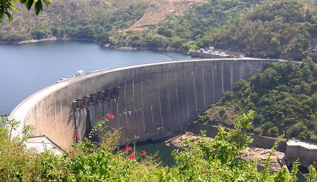
Kariba Dam
Double Curvature Concrete Arch dam · Zambia / Zimbabwe
Kariba Dam is a double curvature concrete arch dam on the Zambezi in Zambia / Zimbabwe, standing 128 m (420 ft) high and completed in 1959. It carries an installed hydroelectric capacity of 1,830 MW. The structure impounds Lake Kariba, about 4,724 km² on the map.
The Kariba Dam is a double curvature concrete arch dam in the Kariba Gorge of the Zambezi river basin between Zambia and Zimbabwe. The dam stands 128 metres (420 ft) tall and 579 metres (1,900 ft) long. The dam forms Lake Kariba, which extends for 280 kilometres (170 mi) and holds 185 cubic kilometres (150,000,000 acre⋅ft) of water.
Adapted from Wikipedia: Kariba Dam (CC BY-SA 4.0).
- Dam type
- Double Curvature Concrete Arch
- Structural height
- 128 m (420 ft)
- Installed capacity
- 1,830 MW
- Impounded river
- Zambezi
- Reservoir
- Lake Kariba
- Location
- Zambia / Zimbabwe
- Year completed
- 1959
- Height rank
- #40 of 115 indexed
- Output rank
- #37 of 102 indexed
- Coordinates
- -16.5208°, 28.7617°
Notable: Holds Lake Kariba, the largest man-made reservoir in the world by volume (180 km³).
Among the 115 dams indexed in YearMaps, Kariba Dam ranks #40 by structural height, behind Jinping-I Dam (305 m). By installed generating capacity it ranks #37, behind Three Gorges Dam (22,500 MW).
Impounded reservoir: Lake Kariba (4,724 km², impounded 1959).
Nearest cities: Kariba (4 km), Kafue (103 km), Mazabuka (130 km).
More about Kariba Dam
Construction
The dam was constructed on the orders of the Government of the Federation of Rhodesia and Nyasaland, a 'federal colony' within the British Empire. The consulting engineers, were Gibb, Coyne, Sogei (Kariba) (PVT.) Limited, a joint venture of consulting engineers, which included Sir Alexander Gibb & Partners (the team was led by Sir Angus Paton), and Coyne et Bellier (the team was led by André Coyne). The double curvature concrete arch dam was constructed between 1955 and 1959 by Cogefar-Impresit of Italy at a cost of $135,000,000 for the first stage with only the Kariba South power cavern. Final construction and the addition of the Kariba North Power cavern by Mitchell Construction was not completed until 1977, due to largely political problems, for a total cost of $480,000,000.
Power generation
The Kariba Dam supplies 2010 MW of electricity to parts of both Zambia (the Copperbelt) and Zimbabwe and generates 6400 GWh per annum. Each country has its own power station on the north and south side of the dam respectively. The south station belonging to Zimbabwe has been in operation since 1960 and had six generators of 125 MW capacity each for a total of 750 MW.
On November 11, 2013 it was announced by Zimbabwe's Finance Minister, Patrick Chinamasa that capacity at the Zimbabwean (South) Kariba hydropower station would be increased by 300 megawatts. The cost of upgrading the facility has been supported by a $319 Million loan from China. The deal is a clear example of Zimbabwe's "Look East" policy, adopted after falling out with Western powers.
Location
The Kariba Dam project was planned and carried out by the Government of the Federation of Rhodesia and Nyasaland. The Federation was often referred to as the Central African Federation (CAF). The CAF was a 'federal colony' within the British Empire in southern Africa that existed from 1953 to the end of 1963, comprising the former self-governing British colony of Southern Rhodesia and the former British protectorates of Northern Rhodesia and Nyasaland. Northern Rhodesia had decided earlier in 1953 (before the Federation was founded) to build a dam within its territory, on the Kafue River, a major tributary of the Zambezi. It would have been closer to Northern Rhodesia's Copperbelt, which was in need of more power.
Sections adapted from Wikipedia: Kariba Dam (CC BY-SA 4.0).
Kariba Dam: Key Facts
| Crest length | 579 m |
|---|---|
| Officially opened | 1959 |
Facts from Wikidata Q1367609 (CC0).
Major River Dossiers
Hand-written studies of the great river systems of history.
Connected Reaches
Nearby watercourses in the same drainage network.
Water Bodies in the Catchment
Settlements Along the Reach
Hydraulic Infrastructure Nearby
Surrounding Terrain
Zambezi: Quick Answers
- Where is Zambezi?
- Zambezi is located in Zambia and Mozambique and Angola and Zimbabwe and Namibia, at 15.6556° S, 29.5866° E.
- Are there dams on the Zambezi?
- Yes. YearMaps records 2 dams on the Zambezi: Cahora Bassa Dam, Kariba Dam.
- What is the tallest dam on the Zambezi?
- Cahora Bassa Dam is the tallest dam recorded on the Zambezi, at 171 m (561 ft), completed in 1974.
- Which dam on the Zambezi generates the most electricity?
- Cahora Bassa Dam has the largest installed hydroelectric capacity on the Zambezi: 2,075 MW. Installed capacity is the maximum rated output, not the annual average.