Skip to content
YearMaps
Cape Verde · Islands

Largest Islands of Cape Verde

Ilhas de Cabo Verde is the largest of the 7 islands recorded for Cape Verde, at 122,980 km², ahead of Santiago at 965 km². The full list follows.

How this list is built: Ranked by mapped area. An island divided between countries is listed under each, with the area of the whole island. It covers the islands indexed in YearMaps, drawn from open geospatial data, and is not an exhaustive national register.

Islands Listed
7
Top Ranked
122,980 km²
Ilhas de Cabo Verde
Second
965 km²
Santiago
Profiled Below
4
Photo, encyclopedia text and figures
Largest Islands of Cape Verde
#NameArea
1Ilhas de Cabo Verde122,980 km²
2Santiago965 km²
3Santo Antão744 km²
4Boa Vista638 km²
5Fogo462 km²
6São Nicolau337 km²
7Sal200 km²

The Islands of Cape Verde in Detail

The 4 islands above that have an encyclopedia article, in the same order, each with its photograph, figures and the places around it.

Santo Antão
Image via Wikimedia Commons (author and licence on the file page).

Santo Antão

Island · 744 km²

Santo Antão is an island in Africa (North Atlantic Ocean), covering an estimated 744 km².

Santo Antão (Portuguese for "Saint Anthony") is the northwesternmost island of Cape Verde. At 785 km2 (303 sq mi), it is the largest of the Barlavento Islands group, and the second largest island of Cape Verde. The nearest island is São Vicente to the southeast, separated by the sea channel Canal de São Vicente. Its population was 38,200 in mid 2019, making it the fourth most populous island of Cape Verde after Santiago, São Vicente and Sal. Its largest city is Porto Novo located on the southern coast (population 9,310 in 2010).

Adapted from Wikipedia: Santo Antão, Cape Verde (CC BY-SA 4.0).

Feature class
Island
Mapped extent
744 km²
Size rank
#312 of 445 islands
Region
Africa
Subregion
North Atlantic Ocean
Coordinates
17.0334°, -25.2186°
Summits:
Pico del Teide (3,718 m), Loma Mansa (1,945 m), Mount Wuteve (1,380 m)
Ranges:
Loma Mountains (Africa), Anti Atlas (Africa)
Settlements:
Mindelo (29 km), Praia (297 km), Dakar (867 km)

View on the live map

More about Santo Antão

Geography

Santo Antão is 42.75 km (26.56 mi) long (east-west) and 23.97 km (14.89 mi) wide (north-south). The island is of volcanic origin and very mountainous, characterized by two high plateaus and several steep river valleys. The southern part of the island has a desert climate, while the northeast and the higher elevations are semi-arid.

The tallest mountain is Tope de Coroa, reaching an elevation of 1,979 m. Other high mountains on the island are Monte Tomé (1,863 m), Gudo de Cavaleiro (1,810 m), Monte Moroços (1,767 m) and Pico da Cruz (1,584 m).

Santo Antão island has a hot desert climate (Köppen climate classification: BWh) in Sinagoga and Porto Novo and a cold semi-arid climate (Köppen climate classification: BSk) in Espongeiro.

History

The island was discovered in 1461 or 1462 by Diogo Afonso, together with the islands of São Vicente and São Nicolau. Settlement of the island started in the first half of the 16th century. The main settlement was Ribeira Grande. Other settlements such as Ponta do Sol, Pombas and Porto Novo developed in the 19th century.

In 1732 the Municipality of Santo Antão was created, with its seat in the town Ribeira Grande. In 1867 this was divided into the municipality of Paul (covering the area of current Paul and Porto Novo) and the municipality of Ribeira Grande. These were merged in 1895 into one municipality. The municipalities of Paul and Ribeira Grande were recreated in 1917.

Economy

The island's agriculture products include sugar cane, yams, cassava, bananas, mangoes, and grain. The main product on the island is a kind of rum known as grogue. Mills continue to distill grogue in the Paul Valley.

Due to its mountainous nature, most of the island's plantations are done in terraces, obviating the use of machinery and requiring immense manual labor. Recently, some experiences using drip irrigation have been taking place in order to mitigate the drought conditions.

The exportation of many of the island's agriculture products to other islands has been prohibited for nearly two decades because of the millipede (Spinotarsus caboverdus) blight, but the quarantine was lifted in 2008.

Tourism is becoming one of the most dominant industries on the island.

Sections adapted from Wikipedia: Santo Antão, Cape Verde (CC BY-SA 4.0).

Santo Antão: Key Facts

Key facts about Santo Antão
Area779 km²
Population47,124
Highest pointTopo da Coroa
Surrounded byAtlantic Ocean

Facts from Wikidata Q112232 (CC0).

Boa Vista
Image via Wikimedia Commons (author and licence on the file page).

Boa Vista

Island · 638 km²

Boa Vista is an island in Africa (North Atlantic Ocean), covering an estimated 638 km².

Boa Vista (Portuguese for "good view"), sometimes spelled Boavista, is a desert-like island that belongs to the Cape Verde Islands. At 631 km2 (244 sq mi), it is the third largest island of the Cape Verde archipelago.

The island of Boa Vista is closer to the African continent than all the other islands in Cape Verde, being the easternmost island of all. The distance between Boa Vista and Senegal is only 450 km. The capital of Boa Vista, Sal Rei, is located in the north-western part of the island. Boa Vista is mainly known for its beaches, turtles and traditional music.

Adapted from Wikipedia: Boa Vista, Cape Verde (CC BY-SA 4.0).

Feature class
Island
Mapped extent
638 km²
Size rank
#320 of 445 islands
Region
Africa
Subregion
North Atlantic Ocean
Coordinates
16.1026°, -22.8075°
Summits:
Loma Mansa (1,945 m), Pico del Teide (3,718 m), Mount Wuteve (1,380 m)
Ranges:
Loma Mountains (Africa), Guinea Highlands (Africa)
Settlements:
Praia (152 km), Mindelo (249 km), Dakar (592 km)

View on the live map

More about Boa Vista

Geography

Boa Vista is the third largest island after Santo Antão and Santiago, with an area of 631.1 square kilometres. It is situated south of Sal and north of Maio. The island is generally flat, but it has numerous hills like Monte Estância (the highest point of the island at 387 m), Monte Santo António, Rocha Estância, Morro de Areia, Morro Negro, Monte Caçador, Pico Forcado and Monte Vigia.

Boa Vista is famous for its large beaches like Atalanta, Cabral, Chaves, Ervatão, Gatas, Santa Mónica and Varandinha. Its northernmost point is Ponta do Sol; its westernmost point Ponta Varandinha. Its main river is the Ribeira do Rabil, which has the largest basin area of all Cape Verde at 199 km2 (77 sq mi). Boa Vista is also notable for its desert Deserto de Viana and its dune fields.

History

The uninhabited island Boa Vista was discovered by António de Noli and Diogo Gomes in 1460. Until the end of the 16th century the only human activity on the island was breeding wild cattle. The island's first settlement, now known as Povoação Velha, was established in 1620 for its salt deposits, which were mainly exploited by the English. In 1820, after many pirate attacks, the population moved to Porto Inglês, later renamed Sal Rei, which had been founded at the end of the 18th century. As did much of the Cape Verdean economy, the exploitation of salt on Boa Vista also relied largely on slavery. A Portuguese-British commission to end slavery was established in Boa Vista in 1842, but slavery was not completely abolished until 1876.

Economy

Previously, the inhabitants of Boa Vista survived off salt collection and date farming. Now they still earn money from date farming, but also from tourism. A lot of people work in the tourism sector, as taxi drivers, employees in the various hotel chains or souvenir salesmen in Sal Rei. The income from tourism has risen rapidly since the international airport opened in 2007. There are several hotels and beach resorts on the island.

Sections adapted from Wikipedia: Boa Vista, Cape Verde (CC BY-SA 4.0).

Boa Vista: Key Facts

Key facts about Boa Vista
Area620 km²
Population12,000 (2013)
Highest pointMonte Estância
Surrounded byAtlantic Ocean

Facts from Wikidata Q110440 (CC0).

São Nicolau
Image via Wikimedia Commons (author and licence on the file page).

São Nicolau

Island · 337 km²

São Nicolau is an island in Africa (North Atlantic Ocean), covering an estimated 337 km².

São Nicolau (Portuguese for Saint Nicholas) is one of the Barlavento (Windward) islands of Cape Verde. It is located between the islands of Santa Luzia and Sal. Its population is 12,424 (2015), with an area of 343 km2 (132 sq mi). The main towns are Ribeira Brava and Tarrafal de São Nicolau.

Adapted from Wikipedia: São Nicolau, Cape Verde (CC BY-SA 4.0).

Feature class
Island
Mapped extent
337 km²
Size rank
#353 of 445 islands
Region
Africa
Subregion
North Atlantic Ocean
Coordinates
16.6041°, -24.3237°
Summits:
Pico del Teide (3,718 m), Loma Mansa (1,945 m), Mount Wuteve (1,380 m)
Ranges:
Loma Mountains (Africa), Guinea Highlands (Africa)
Settlements:
Mindelo (78 km), Praia (207 km), Dakar (763 km)

View on the live map

More about São Nicolau

Geography

The mountainous island is mostly agricultural but is subject to droughts, especially in the lower lying areas. The highest point on the island is Monte Gordo (1,312 m), in the western half of the island. The eastern part is a chain of lower mountains, including Monte Bissau and Pico de Alberto.

History

The island was discovered in 1461 or 1462 by Diogo Afonso, together with the islands of São Vicente and Santo Antão. It was first settled in the seventeenth century. The settlement Porto de Lapa was abandoned in 1653 due to pirate attacks, and the town Ribeira Brava was founded in the interior. It was the seat of the Roman Catholic Diocese of Santiago de Cabo Verde between 1786 and 1943. The roadstead of Tarrafal de São Nicolau became an anchorage for whaling ships in the 19th century. It is now the largest settlement of the island.

Sections adapted from Wikipedia: São Nicolau, Cape Verde (CC BY-SA 4.0).

São Nicolau: Key Facts

Key facts about São Nicolau
Area343 km²
Population12,700
Highest pointMonte Gordo
Surrounded byAtlantic Ocean

Facts from Wikidata Q492509 (CC0).

Sal
Image via Wikimedia Commons (author and licence on the file page).

Sal

Island · 200 km²

Sal is an island in Africa (North Atlantic Ocean), covering an estimated 200 km².

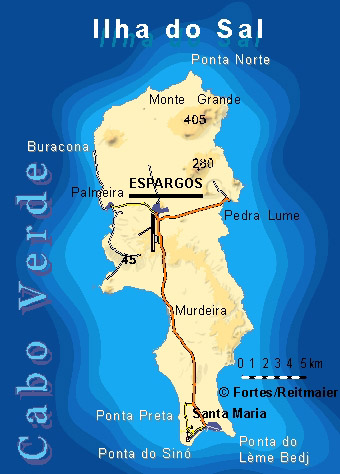
Sal (Portuguese for "salt") is an island in Cape Verde. Sal is a tourist destination with white sand beaches and over 350 days of sunshine a year. It is one of the three sandy eastern islands of the Cape Verde archipelago in the central Atlantic Ocean, 350 miles (560 km) off the west coast of Africa. Cabo Verde is known for year-round kiteboarding, for the large reserve of Caretta turtles which hatch from July to September, and the music of Cesária Évora. Cabo Verde is now the world's largest nesting aggregation for this turtle species, and Sal has the second-largest rookery.

Adapted from Wikipedia: Sal, Cape Verde (CC BY-SA 4.0).

Feature class
Island
Mapped extent
200 km²
Size rank
#369 of 445 islands
Region
Africa
Subregion
North Atlantic Ocean
Coordinates
16.7934°, -22.9498°
Summits:
Pico del Teide (3,718 m), Loma Mansa (1,945 m), Mount Wuteve (1,380 m)
Ranges:
Loma Mountains (Africa), Guinea Highlands (Africa)
Settlements:
Praia (217 km), Mindelo (218 km), Dakar (630 km)

View on the live map

More about Sal

Geography

The island is 29.7 km long and 11.8 km wide. Its area is 219.84 km2 (84.88 sq mi). It is one of the three sandy eastern islands (Sal, Boa Vista and Maio) of the archipelago, with white sandy beaches. The island is fairly flat; its highest point is Monte Grande, at 406 m elevation. The uninhabited islet Ilhéu Rabo de Junco lies near the west coast of Sal. Saline marshes can be found in the Pedra de Lume crater and north of Santa Maria.

Sal Island has on average 350 days of sunshine a year. Winds mainly blow from the northeast. However, some days do also have clouds, but they tend to be scattered and seldom bring rain. The 'rainy season' is from July to mid-October, although rainfall is still low.

History

The island was discovered on 3 December 1460 and named Chã ("flat"). This name was changed into the current "Sal" when the two large salt ponds (Pedra de Lume and Santa Maria) were discovered. The first three centuries after its discovery, the island was only sparsely inhabited; in 1720 there was a small fishing village near present Palmeira. This changed when the salt industry was developed at the end of the 18th century, starting in Pedra de Lume. Santa Maria was founded in the south of the island in 1830 by Manuel António Martins. During this time the salt industry thrived, with 30,000 tons of salt being exported in the early years. Most of the salt was exported to Brazil until its nationalization in 1887, Portuguese and French salt investors resumed salt production until 1984.

Demographics

As of 1832, the population was estimated at 400 people. Until 1960, it was the least populous island of the nine inhabited islands of Cape Verde, with less than 3,000 inhabitants. Since then the population has been growing rapidly, reaching around 40,000 in 2019, which makes it the third most populous island in Cape Verde, after Santiago and São Vicente, and having overtaken Santo Antão and Fogo.

Economy

Sal's main town, Espargos, is home to one of the nation's international airports. Tourism, focused on the area of Santa Maria, has replaced salt and fishing as the main source of income. In 2017, 48.2% of the country's available beds were on the island of Sal. The living standards on the island are among the best in the Cape Verde archipelago. The island's GDP per capita as of 2015 is 495,827 escudos (4,497 euro).

Sections adapted from Wikipedia: Sal, Cape Verde (CC BY-SA 4.0).

Sal: Key Facts

Key facts about Sal
Area215 km²
Population35,267 (2018)
Highest pointMonte Grande (Sal), Cape Verde
Surrounded byAtlantic Ocean

Facts from Wikidata Q111989 (CC0).

More on Cape Verde

Quick Answers

What is the largest island in Cape Verde?
Ilhas de Cabo Verde, at 122,980 km². Santiago is second at 965 km². Rankings cover the islands indexed in YearMaps.
How many islands are there in Cape Verde?
YearMaps lists 7 islands for Cape Verde. This is the number mapped in the atlas, not an official national count.