Skip to content
YearMaps
Spain · Mountains

Highest Mountains in Spain

Pico del Teide is the highest of the 9 mountains recorded for Spain, at 3,718 m, ahead of Mulhacén at 3,479 m. The full list follows.

How this list is built: Ranked by summit elevation above sea level. A summit on a border is listed under both countries. It covers the mountains indexed in YearMaps, drawn from open geospatial data, and is not an exhaustive national register.

Mountains Listed
9
Top Ranked
3,718 m
Pico del Teide
Second
3,479 m
Mulhacén
Profiled Below
6
Photo, encyclopedia text and figures
Highest Mountains in Spain
#NameElevation
1Pico del Teide3,718 m
2Mulhacén3,479 m
3Pico de Aneto3,404 m
4Torre de Cerredo2,648 m
5Pico de Almanzor2,592 m
6Moncayo2,313 m
7San Lorenzo2,271 m
8El Teleno2,183 m
9Puig Mayor1,445 m

The Mountains of Spain in Detail

The 6 mountains above that have an encyclopedia article, in the same order, each with its photograph, figures and the places around it.

Pico del Teide
Image via Wikimedia Commons (author and licence on the file page).

Pico del Teide

Mountain · 3,718 m

Pico del Teide is a mountain rising to 3,718 metres (12,198 ft) in Spain, in the Africa region.

Teide (Spanish: El Teide) or Mount Teide (Pico del Teide, pronounced [ˈpiko ðel ˈtejðe]; 'Peak of Teide') is an active stratovolcano on the Spanish island of Tenerife, part of the Canary Islands. Its summit (at 3,715 m (12,188 ft)) is the highest point in Spain and the highest of any island in the Atlantic Ocean. Measured from its base on the ocean floor, Teide reaches a total height of 7,500 m (24,600 ft), making it the third-tallest volcano in the world; UNESCO and NASA also rank it as Earth's third-tallest volcanic structure. Its elevation above sea level makes Tenerife the tenth-highest island in the world.

Teide began forming approximately 170,000 years ago as a result of volcanic activity following a catastrophic landslide. Its base lies within the Las Cañadas caldera, the remains of an older, eroded, and extinct volcano, at an elevation of about 2,190 m (7,190 ft) above sea level. Teide is an active volcano, with its most recent eruption occurring in late 1909 from the El Chinyero vent on the northwestern Santiago rift.

Adapted from Wikipedia: Teide (CC BY-SA 4.0).

Elevation
3,718 m (12,198 ft)
Global rank
#153 of 641 indexed
Region
Africa (#13)
Subregion
North Atlantic Ocean
Country
Spain
Coordinates
28.2708°, -16.6391°

Of the 641 named summits indexed in YearMaps, Pico del Teide ranks #153 by elevation, below Gunung Rinjani (3,726 m) and above Cerro San Rafael (3,710 m).

Ranges:
Anti Atlas (Africa), Haut Atlas (Africa)
Neighbouring summits:
Jebel Lekst (2,359 m), Jebel Toubkal (4,165 m), Rock of Gibraltar (426 m)
Settlements below:
Santa Cruz de Tenerife (44 km), Las Palmas (120 km), Arrecife (312 km)

View on the live map

More about Pico del Teide

Geography

Teide is located on Tenerife, the largest island of the Canary Islands, situated in the Atlantic Ocean, 290 km (180 mi) northwest of the coast of Western Sahara. The volcano is located in a central position on the Tenerife island. Administratively, the Canary Islands are a Spanish autonomous community. Teide itself is located within the commune of La Orotava in the province of Santa Cruz de Tenerife.

Before reliable measurements were available, Teide was considered by Europeans to be the highest mountain on Earth for a long time. With a height of 3,715 m (12,188 ft), it is the highest point in Spain and the Atlantic Ocean.

Geology

Teide is a stratovolcano created by the same forces which formed the Canary Islands. The islands are aligned relatively east to west, but continue to the northeast in a series of undersea mountains which are part of the same volcanic region as the Canary Islands. Dating indicates that the age of these islands changes from east to west, with the older islands and undersea mountains (seamounts) to the east and more recent ones to the west. This makes Fuerteventura and Lanzarote the oldest islands, from 20.2 Mya, and El Hierro the youngest, from 1.1 Mya. Counting the undersea mountains, Lars (a seamount) is the oldest, from 68 Mya.

Sections adapted from Wikipedia: Teide (CC BY-SA 4.0).

Pico del Teide: Key Facts

Key facts about Pico del Teide
Topographic prominence3,715 m

Facts from Wikidata Q38954 (CC0).

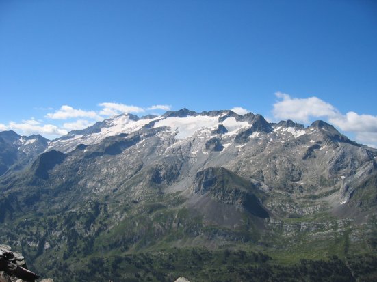
Mulhacén
Image via Wikimedia Commons (author and licence on the file page).

Mulhacén

Mountain · 3,479 m

Mulhacén is a mountain rising to 3,479 metres (11,414 ft) in Spain, in the Europe region.

Mulhacén ([mulaˈθen]), with an elevation of 3,479 metres (11,414 ft), is the highest mountain in peninsular Spain and in all of the Iberian Peninsula. It is part of the Sierra Nevada range in the Penibaetic System. It is named after Abu'l-Hasan Ali, known as Muley Hacén in Spanish, the penultimate Muslim ruler of Granada in the 15th century who, according to legend, was buried on the summit of the mountain. It is still known in present-day Arabic as Jabal Mawla el-Hassan (Mountain of Mawla el-Hassan).

Mulhacén is the highest peak in Southern Europe outside of the Alps. It is also the third-most prominent peak in Western Europe, after Mont Blanc and Mount Etna, and is ranked 64th in the world by prominence. The peak is not exceptionally dramatic in terms of steepness or local relief. The south flank of the mountain is gentle and presents no technical challenge, as is the case for the long west ridge. The shorter, somewhat steeper northeast ridge is slightly more technical. The north face of the mountain is much steeper and offers several routes involving moderately steep climbing on snow and ice (up to French grade AD) in the winter.

Adapted from Wikipedia: Mulhacén (CC BY-SA 4.0).

Elevation
3,479 m (11,414 ft)
Global rank
#174 of 641 indexed
Region
Europe (#11)
Country
Spain
Coordinates
37.0514°, -3.3114°

Of the 641 named summits indexed in YearMaps, Mulhacén ranks #174 by elevation, below Mont Mohi (3,480 m) and above Mt.Baldy (3,476 m).

Ranges:
Sierra Morena (Europe), Er Rif (Africa)
Neighbouring summits:
Rock of Gibraltar (426 m), Pico de Almanzor (2,592 m), Moncayo (2,313 m)
Settlements below:
Granada‎ (27 km), Almería (82 km), Jaén (91 km)

View on the live map

More about Mulhacén

Mulhacén: Key Facts

Key facts about Mulhacén
Topographic prominence3,290 m
Mountain rangeSierra Nevada

Facts from Wikidata Q209528 (CC0).

Pico de Aneto
Image via Wikimedia Commons (author and licence on the file page).

Pico de Aneto

Mountain · 3,404 m

Pico de Aneto is a mountain rising to 3,404 metres (11,168 ft) in Spain, in the Europe region.

Aneto is the highest mountain in the Pyrenees and in Aragon, Spain's third-highest mountain, reaching a height of 3,404 metres (11,168 feet). It is in the Spanish province of Huesca, the northernmost of three Aragonese provinces, 6 kilometres (4 miles) south of the France–Spain border. It forms the southernmost part of the Maladeta massif.

Aneto is located in the Posets-Maladeta Natural Park, in the municipality of Benasque, Huesca province, an autonomous community of Aragon, Spain. It is part of the Maladeta massif and is located in the Benasque valley. It consists of Paleozoic terrain of a granitic nature and Mesozoic materials. Its northern side holds the largest glacier in the Pyrenees, covering 79.6 hectares (197 acres) in 2005; it is shrinking rapidly due to warming summer temperatures and decreasing winter precipitations over the 20th century – it covered 106.7 ha in 1981, and over 200 ha in the 19th century. It is estimated that it has lost more than half of its surface in the last 100 years, and may disappear around 2050.

Adapted from Wikipedia: Aneto (CC BY-SA 4.0).

Elevation
3,404 m (11,168 ft)
Global rank
#189 of 641 indexed
Region
Europe (#12)
Country
Spain
Coordinates
42.6322°, 0.6631°

Of the 641 named summits indexed in YearMaps, Pico de Aneto ranks #189 by elevation, below Muleta (3,405 m) and above Kegueur Terbi (3,376 m).

Ranges:
Pyrenees (Europe), Jura (Europe)
Neighbouring summits:
Pic de Coma Pedrosa (2,943 m), Moncayo (2,313 m), Puy de Sancy (1,885 m)
Settlements below:
Andorra (71 km), Tarbes (82 km), Toulouse (127 km)

View on the live map

More about Pico de Aneto

Geography

Aneto rises to 3,404 m (11,168 ft) above sea level in the centre of the Pyrenees mountain range. It lies entirely in Spain, just south of the main ridge of the Pyrenees and the border between France and Spain. The peak lies in the north-east of the province of Huesca above the town of Benasque.

Aneto occupies the eastern end of the Malditos Massif which primarily consists of a 6 km long ridge, running from north-west to south east at over 3000 m. The ridge connects Aneto towards the east with the more visible Maladeta peak, further to the west, and includes the Coronas peaks and Pico Maldito, which, together with the crest of the portillons, gives the massif its characteristic image.

History

Some 2 km away on its north-west fringe lies the Maladeta peak that, though not being among the five highest peaks in the environment, gave its name to the entire massif. It subsequently earned the greatest interest from climbers, especially in the early 18th century. Mainly, it was a matter of perspective, since from the natural entrance to the valley or arriving from France, its top is in the foreground, while the crest hides the true extent of its eastern neighbour, taller and with larger glaciers. Only when Friedrich von Parrot reached the top of the Maladeta in 1817, came the realisation that both Aneto as well as its neighbours the Pico del Medio, the Punta de Astorg, the Pico Maldito and la Aguja Schmidt Endell towered higher.

Sections adapted from Wikipedia: Aneto (CC BY-SA 4.0).

Pico de Aneto: Key Facts

Key facts about Pico de Aneto
Topographic prominence2,811 m
Mountain rangeMacizo de la Maladeta

Facts from Wikidata Q208081 (CC0).

Torre de Cerredo
Image via Wikimedia Commons (author and licence on the file page).

Torre de Cerredo

Mountain · 2,648 m

Torre de Cerredo is a mountain rising to 2,648 metres (8,688 ft) in Spain, in the Europe region.

Torre Cerredo, also called Torrecerredo or Torre de Cerredo (Asturian: La Torre Cerréu), is the highest peak of the Cantabrian Mountains, northern Spain.

With a prominence of 1,931 m, it is an ultra-prominent peak and the third most prominent peak of the Iberian Peninsula.

Adapted from Wikipedia: Torre Cerredo (CC BY-SA 4.0).

Elevation
2,648 m (8,688 ft)
Global rank
#309 of 641 indexed
Region
Europe (#25)
Country
Spain
Coordinates
43.1947°, -4.8450°

Of the 641 named summits indexed in YearMaps, Torre de Cerredo ranks #309 by elevation, below Kimhandu (2,653 m) and above Inyaptuk Golets (2,641 m).

Ranges:
Sierra Morena (Europe), Pyrenees (Europe)
Neighbouring summits:
Moncayo (2,313 m), Pico de Almanzor (2,592 m), Pico de Aneto (3,404 m)
Settlements below:
Gijón (76 km), Oviedo (82 km), Santander (87 km)

View on the live map

More about Torre de Cerredo

Geography

The mountain has an elevation of 2,650 metres, making it the highest peak of the Picos de Europa and the Cantabrian Mountains. Torre Cerredo is located on the central massif of the Picos de Europa, the Urrieles Massif, on the limits of the provinces Asturias and León. Its summit towers 2,200 metres over the river Cares and offers wide views over the western massif and the Cares' tributaries.

Sections adapted from Wikipedia: Torre Cerredo (CC BY-SA 4.0).

Torre de Cerredo: Key Facts

Key facts about Torre de Cerredo
Topographic prominence1,931 m
Mountain rangeUrrieles Massif

Facts from Wikidata Q1520376 (CC0).

Pico de Almanzor
Image via Wikimedia Commons (author and licence on the file page).

Pico de Almanzor

Mountain · 2,592 m

Pico de Almanzor is a mountain rising to 2,592 metres (8,504 ft) in Spain, in the Europe region. From PeakBagger.com, with kind permission..

Pico Almanzor is the highest mountain in central Spain. Situated in the Sierra de Gredos in the province of Ávila, Almanzor is 2,591 metres (8,501 ft) high. It is made of granite. The mountain is also known as Pico de Almanzor and Moro Almanzor.

Adapted from Wikipedia: Pico Almanzor (CC BY-SA 4.0).

Elevation
2,592 m (8,504 ft)
Global rank
#320 of 641 indexed
Region
Europe (#27)
Country
Spain
Coordinates
40.2601°, -5.3000°

Of the 641 named summits indexed in YearMaps, Pico de Almanzor ranks #320 by elevation, below Inyangani (2,592 m) and above Gora Cherskoga (2,588 m).

Ranges:
Sierra Morena (Europe), Er Rif (Africa)
Neighbouring summits:
Torre de Cerredo (2,648 m), Moncayo (2,313 m), Mulhacén (3,479 m)
Settlements below:
Salamanca (85 km), Toledo (118 km), Madrid (138 km)

View on the live map

More about Pico de Almanzor

History

The mountain got its name from المنصور: Al-Manṣūr (Arabic for "the victorious"). Al-Mansur Ibn Abi Aamir was a general and statesman in Muslim Spain (Caliphate of Cordoba) during the late 10th century. Muhammad bin Abi Amir was his real name; the Moors in Spain gave him the title of Al-Mansur due to his victories over the Christians.

During his many campaigns, Al-Mansur passed near this mountain and he was captivated by its beauty.

Pico Almanzor was climbed for the first time in September 1899 by M. González de Amezúa and José Ibrián. Espada, Ontañón and Abricarro made the first winter ascent in 1903. In 1960, a 1-metre-tall iron cross was placed on the summit.

Sections adapted from Wikipedia: Pico Almanzor (CC BY-SA 4.0).

Pico de Almanzor: Key Facts

Key facts about Pico de Almanzor
Topographic prominence1,689 m
Mountain rangeSierra de Gredos

Facts from Wikidata Q203353 (CC0).

Moncayo
Image via Wikimedia Commons (author and licence on the file page).

Moncayo

Mountain · 2,313 m

Moncayo is a mountain rising to 2,313 metres (7,589 ft) in Spain, in the Europe region. From PeakBagger.com, with kind permission..

Moncayo is a 15 km long and about 7 km wide mountain chain giving name to the Tarazona y el Moncayo comarca, Aragon, Spain. The Moncayo's highest summit, San Miguel (2,314 metres (7,592 ft)), is the highest point in the 500 km long Sistema Ibérico.

The Moncayo is located between the provinces of Zaragoza in Aragon and Soria in Castile and León. The ridge's highest summits are usually covered in snow between October and May every year.

Adapted from Wikipedia: Moncayo Range (CC BY-SA 4.0).

Elevation
2,313 m (7,589 ft)
Global rank
#366 of 641 indexed
Region
Europe (#34)
Country
Spain
Coordinates
41.7800°, -1.8400°

Of the 641 named summits indexed in YearMaps, Moncayo ranks #366 by elevation, below Seweweekspoort Pk (2,325 m) and above Lalla Khedidja (2,308 m).

Ranges:
Pyrenees (Europe), Sierra Morena (Europe)
Neighbouring summits:
Pico de Aneto (3,404 m), Pic de Coma Pedrosa (2,943 m), Torre de Cerredo (2,648 m)
Settlements below:
Zaragoza (80 km), Logroño (91 km), Pamplona (117 km)

View on the live map

More about Moncayo

Description

Besides the San Miguel, the Moncayo massif includes two other peaks that are almost identical and are located close together, Cerro San Juan (2,283 m) and Peña Lobera (2,226 m).

This mountain was mentioned as Mons Caius by Marcus Valerius Martialis in Ancient Roman times.

The nearest large town to Moncayo is Tarazona, with many old and historical buildings, located on the massif's northern side 10 km away from it. There are also smaller villages closer to the mountain.

The Sierra de Nava Alta and Sierra del Bollón are eastern prolongations of the Moncayo Massif.

Sections adapted from Wikipedia: Moncayo Range (CC BY-SA 4.0).

Moncayo: Key Facts

Key facts about Moncayo
Mountain rangeIberian System

Facts from Wikidata Q23994805 (CC0).

More on Spain

Quick Answers

What is the highest mountain in Spain?
Pico del Teide, at 3,718 m. Mulhacén is second at 3,479 m. Rankings cover the mountains indexed in YearMaps.
How many mountains are there in Spain?
YearMaps lists 9 mountains for Spain. This is the number mapped in the atlas, not an official national count.