
UNESCO World Heritage Sites in Spain
Spain has 49 sites on the UNESCO World Heritage List (44 cultural, 4 natural and 1 mixed), the first inscribed in 1984 (Alhambra, Generalife and Albayzín, Granada). The map below plots every one of them alongside the rest of the List, and each site is written up in full further down the page.
- World Heritage Sites
- 49
- Cultural
- 44
- Natural and Mixed
- 5
- First Inscribed
- 1984
Map of World Heritage Sites in Spain
CulturalNaturalMixedIn DangerLarge dots are in Spain. Click a dot to read about the site.

Alhambra, Generalife and Albayzín, Granada
Spain · 37.1767° N, 3.5944° W · 5 km² · 2 km from Granada
Rising above the modern lower town, the Alhambra and the Albaycín, situated on two adjacent hills, form the medieval part of Granada. To the east of the Alhambra fortress and residence are the magnificent gardens of the Generalife, the former rural residence of the emirs who ruled this part of Spain in the 13th and 14th centuries. The residential district of the Albaycín is a rich repository of Moorish vernacular architecture, into which the traditional Andalusian architecture blends harmoniously.
Description from the UNESCO World Heritage Centre (CC BY-SA IGO 3.0).
Why Alhambra, Generalife and Albayzín, Granada Is Listed
- (i)
- A masterpiece of human creative genius.
- (ii)
- An important interchange of human values.
- (iii)
- A unique testimony to a cultural tradition or civilisation.
- (iv)
- An outstanding example of a type of building or landscape.

Burgos Cathedral
Spain · 42.3408° N, 3.7045° W · 2 km from Burgos
The Cathedral of Saint Mary of Burgos (Spanish: Catedral de Burgos) is a Catholic church dedicated to the Virgin Mary located in the historical center of the Spanish city of Burgos. Its official name is the Holy Metropolitan Cathedral Basilica Church of St Mary of Burgos (Spanish: Santa Iglesia Catedral Basílica Metropolitana de Santa María de Burgos).
Its construction began in 1221, in the style of French Gothic architecture and is based on a Latin cross. After a hiatus of almost 200 years, it went through major embellishments of great splendor in the 15th and 16th centuries: the spires of the main facade, the capilla del Condestable, 'Chapel of the Constable' and dome of the transept. These are elements of the flamboyant Gothic which gives the cathedral its unmistakable profile. The last works of importance (the Sacristy or the Chapel of Saint Thecla) were performed in the 18th century, during which the Gothic portals of the main facade were also modified. The style of the cathedral is the Gothic, although it has several decorative Renaissance and Baroque elements as well.
Adapted from Wikipedia: Burgos Cathedral (CC BY-SA 4.0).
Why Burgos Cathedral Is Listed
- (ii)
- An important interchange of human values.
- (iv)
- An outstanding example of a type of building or landscape.
- (vi)
- A direct association with events, ideas or beliefs of universal significance.
More about Burgos Cathedral
UNESCO's Description
Our Lady of Burgos was begun in the 13th century at the same time as the great cathedrals of the Ile-de-France and was completed in the 15th and 16th centuries. The entire history of Gothic art is summed up in its superb architecture and its unique collection of works of art, including paintings, choir stalls, reredos, tombs and stained-glass windows.
From the UNESCO World Heritage Centre (CC BY-SA IGO 3.0).
History of the cathedral
Burgos became a bishopric in 1075 by the king Alfonso VI of León and Castile "the Brave" on authority of Pope Gregory VII, giving it a canonical continuation with the episcopal tradition of the diocese of Oca, whose prelate was in 589 already recorded as a signatory to the Third Council of Toledo during the reign of the Visigoths.
The monarch dedicated the construction of a cathedral to the Virgin Mary. Its design is not known, but it is supposedly Romanesque and of the type of contemporary works (of the Abbey of Santo Domingo de Silos, of the Monastery of San Pedro de Arlanza of San Martín de Tours de Frómista or the Cathedral of Jaca).
Sections adapted from Wikipedia: Burgos Cathedral (CC BY-SA 4.0).
Key Facts
| Established | 1221 |
|---|---|
| Area | 0 km² |
| Architectural style | Gothic architecture, Spanish Gothic architecture |
Facts from Wikidata Q744420 (CC0).

historic centre of Córdoba
Spain · 37.8792° N, 4.7797° W · 1 km² · 1 km from Córdoba
The historic centre of Córdoba, Spain is one of the largest of its kind in Europe. In 1984, UNESCO registered the Mosque–Cathedral of Córdoba as a World Heritage Site. A decade later, it expanded the inscription to include much of the old town. The historic centre has a wealth of monuments preserving large traces of Roman, Islamic, and Christian times.
Adapted from Wikipedia: Historic centre of Córdoba (CC BY-SA 4.0).
Why historic centre of Córdoba Is Listed
- (i)
- A masterpiece of human creative genius.
- (ii)
- An important interchange of human values.
- (iii)
- A unique testimony to a cultural tradition or civilisation.
- (iv)
- An outstanding example of a type of building or landscape.
More about historic centre of Córdoba
UNESCO's Description
Cordoba's period of greatest glory began in the 8th century after the Moorish conquest, when some 300 mosques and innumerable palaces and public buildings were built to rival the splendours of Constantinople, Damascus and Baghdad. In the 13th century, under Ferdinand III, the Saint, Cordoba's Great Mosque was turned into a cathedral and new defensive structures, particularly the Alcázar de los Reyes Cristianos and the Torre Fortaleza de la Calahorra, were erected.
From the UNESCO World Heritage Centre (CC BY-SA IGO 3.0).
Historical background
First a Carthaginian township, Córdoba was captured by the Romans in 206 BC, soon becoming the capital of Hispania Citerior with fine buildings and imposing fortifications. In the 6th century, with the crumbling of the Roman Empire, the city fell to the Visigoths until the beginning of the 8th century when it was conquered by the Moors. In 716, Córdoba became a provincial capital and, in 766, capital of the Muslim emirate of al-Andalus. By the 10th century, as the Caliphate of Córdoba it had become one of the most advanced cities in the world, recognized for its culture, learning and religious tolerance. In addition to a huge library, the city enclosed over 300 mosques and a multitude of palaces and administrative buildings.
Sections adapted from Wikipedia: Historic centre of Córdoba (CC BY-SA 4.0).

Monastery and Site of the Escurial, Madrid
Spain · 40.5892° N, 4.1478° W · 1 km² · 44 km from Madrid
Built at the end of the 16th century on a plan in the form of a grill, the instrument of the martyrdom of St Lawrence, the Escurial Monastery stands in an exceptionally beautiful site in Castile. Its austere architecture, a break with previous styles, had a considerable influence on Spanish architecture for more than half a century. It was the retreat of a mystic king and became, in the last years of Philip II's reign, the centre of the greatest political power of the time.
Description from the UNESCO World Heritage Centre (CC BY-SA IGO 3.0).
Why Monastery and Site of the Escurial, Madrid Is Listed
- (i)
- A masterpiece of human creative genius.
- (ii)
- An important interchange of human values.
- (vi)
- A direct association with events, ideas or beliefs of universal significance.

Works of Antoni Gaudí
Spain · 41.3638° N, 2.0278° E · 13 km from Barcelona
Seven properties built by the architect Antoni Gaudí (1852–1926) in or near Barcelona testify to Gaudí’s exceptional creative contribution to the development of architecture and building technology in the late 19th and early 20th centuries. These monuments represent an eclectic, as well as a very personal, style which was given free reign in the design of gardens, sculpture and all decorative arts, as well as architecture. The seven buildings are: Parque Güell; Palacio Güell; Casa Mila; Casa Vicens; Gaudí’s work on the Nativity façade and Crypt of La Sagrada Familia; Casa Batlló; Crypt in Colonia Güell.
Description from the UNESCO World Heritage Centre (CC BY-SA IGO 3.0).
Why Works of Antoni Gaudí Is Listed
- (i)
- A masterpiece of human creative genius.
- (ii)
- An important interchange of human values.
- (iv)
- An outstanding example of a type of building or landscape.
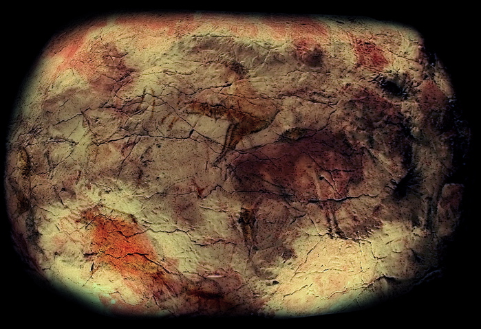
Cave of Altamira and Paleolithic Cave Art of Northern Spain
Spain · 43.3825° N, 4.1161° W · 26 km from Santander
The Cave of Altamira and Paleolithic Cave Art of Northern Spain (Cueva de Altamira y arte rupestre paleolítico del Norte de España) is a grouping of 18 caves of northern Spain, which together represent the apogee of Upper Paleolithic cave art in Europe between 35,000 and 11,000 years ago (Aurignacian, Gravettian, Solutrean, Magdalenian, Azilian). In 2008, they were collectively designated a World Heritage Site by UNESCO.
Chief among these caves is Altamira, located within the town of Santillana del Mar in Cantabria. It remains one of the most important painting cycles of prehistory, originating in the Magdalenian and Solutrean periods of the Upper Paleolithic. This cave's artistic style represents the Franco-cantabrian school, characterized by the realism of its figural representation. Altamira Cave was declared a World Heritage Site in 1985. In 2008, the World Heritage Site was expanded to include 17 additional caves located in three autonomous communities of northern Spain: Asturias, Cantabria and the Basque Country.
Adapted from Wikipedia: Cave of Altamira and Paleolithic Cave Art of Northern Spain (CC BY-SA 4.0).
Why Cave of Altamira and Paleolithic Cave Art of Northern Spain Is Listed
- (i)
- A masterpiece of human creative genius.
- (iii)
- A unique testimony to a cultural tradition or civilisation.
More about Cave of Altamira and Paleolithic Cave Art of Northern Spain
UNESCO's Description
Seventeen decorated caves of the Paleolithic age were inscribed as an extension to the Altamira Cave, inscribed in 1985. The property will now appear on the List as Cave of Altamira and Paleolithic Cave Art of Northern Spain. The property represents the apogee of Paleolithic cave art that developed across Europe, from the Urals to the Iberian Peninusula, from 35,000 to 11,000 BC. Because of their deep galleries, isolated from external climatic influences, these caves are particularly well preserved. The caves are inscribed as masterpieces of creative genius and as the humanity’s earliest accomplished art. They are also inscribed as exceptional testimonies to a cultural tradition and as outstanding illustrations of a significant stage in human history.
From the UNESCO World Heritage Centre (CC BY-SA IGO 3.0).
Key Facts
| Established | 1985 |
|---|
Facts from Wikidata Q899302 (CC0).

Monuments of Oviedo and the Kingdom of the Asturias
Spain · 43.3789° N, 5.8658° W · 4 km from Oviedo
In the 9th century the flame of Christianity was kept alive in the Iberian peninsula in the tiny Kingdom of the Asturias. Here an innovative pre-Romanesque architectural style was created that was to play a significant role in the development of the religious architecture of the peninsula. Its highest achievements can be seen in the churches of Santa María del Naranco, San Miguel de Lillo, Santa Cristina de Lena, the Cámara Santa and San Julián de los Prados, in and around the ancient capital city of Oviedo. Associated with them is the remarkable contemporary hydraulic engineering structure known as La Foncalada.
Description from the UNESCO World Heritage Centre (CC BY-SA IGO 3.0).
Why Monuments of Oviedo and the Kingdom of the Asturias Is Listed
- (i)
- A masterpiece of human creative genius.
- (ii)
- An important interchange of human values.
- (iv)
- An outstanding example of a type of building or landscape.

Old Town of Ávila with its Extra-Muros Churches
Spain · 40.6564° N, 4.7001° W · 89 km from Salamanca
Founded in the 11th century to protect the Spanish territories from the Moors, this 'City of Saints and Stones', the birthplace of St Teresa and the burial place of the Grand Inquisitor Torquemada, has kept its medieval austerity. This purity of form can still be seen in the Gothic cathedral and the fortifications which, with their 82 semicircular towers and nine gates, are the most complete in Spain.
Description from the UNESCO World Heritage Centre (CC BY-SA IGO 3.0).
Why Old Town of Ávila with its Extra-Muros Churches Is Listed
- (iii)
- A unique testimony to a cultural tradition or civilisation.
- (iv)
- An outstanding example of a type of building or landscape.

old town of Santiago de Compostela
Spain · 42.8808° N, 8.5447° W · 1 km² · 0 km from Santiago de Compostela
The Old Town of Santiago de Compostela is an urban area of the Galician capital that is characterized by its ancient and monumental architecture.
Adapted from Wikipedia: Old Town of Santiago de Compostela (CC BY-SA 4.0).
Why old town of Santiago de Compostela Is Listed
- (i)
- A masterpiece of human creative genius.
- (ii)
- An important interchange of human values.
- (vi)
- A direct association with events, ideas or beliefs of universal significance.
More about old town of Santiago de Compostela
UNESCO's Description
This famous pilgrimage site in north-west Spain became a symbol in the Spanish Christians' struggle against Islam. Destroyed by the Muslims at the end of the 10th century, it was completely rebuilt in the following century. With its Romanesque, Gothic and Baroque buildings, the Old Town of Santiago is one of the world's most beautiful urban areas. The oldest monuments are grouped around the tomb of St James and the cathedral, which contains the remarkable Pórtico de la Gloria.
From the UNESCO World Heritage Centre (CC BY-SA IGO 3.0).
Description
II. Witness a significant exchange of human values over a period of time or within a cultural area of the world, in the development of architecture or technology, monumental arts, urban planning or landscape design.
VI. Be directly or tangibly associated with living events or traditions, with ideas or beliefs, with artistic and literary works of exceptional universal importance. (The committee considers that this criterion should preferably be accompanied by other criteria.)
The historic centre of the city grew around the cathedral after the mythical discovery of the tomb of apostle James in 813, attracting the pilgrimage of millions of people for centuries, in one of the most remarkable phenomena of medieval history.
Sections adapted from Wikipedia: Old Town of Santiago de Compostela (CC BY-SA 4.0).
Key Facts
| Area | 1.1 km² |
|---|
Facts from Wikidata Q12386144 (CC0).

Old Town of Segovia and its Aqueduct
Spain · 40.9485° N, 4.1167° W · 1 km² · 71 km from Madrid
The Roman aqueduct of Segovia, probably built c. A.D. 50, is remarkably well preserved. This impressive construction, with its two tiers of arches, forms part of the setting of the magnificent historic city of Segovia. Other important monuments include the Alcázar, begun around the 11th century, and the 16th-century Gothic cathedral.
Description from the UNESCO World Heritage Centre (CC BY-SA IGO 3.0).
Why Old Town of Segovia and its Aqueduct Is Listed
- (i)
- A masterpiece of human creative genius.
- (iii)
- A unique testimony to a cultural tradition or civilisation.
- (iv)
- An outstanding example of a type of building or landscape.

Garajonay National Park
Spain · 28.1262° N, 17.2372° W · 40 km² · 104 km from Santa Cruz de Tenerife
Garajonay National Park (Spanish: Parque nacional de Garajonay, pronounced [ˈpaɾke naθjoˈnal de ɣaɾaxoˈnaj]) is located in the center and north of the island of La Gomera, one of the Canary Islands (Spain). It was declared a national park in 1981 and a World Heritage Site by UNESCO in 1986. It occupies 40 km2 (15 sq mi) and it extends into each of the six municipalities on the island.
Nearly 450,000 tourists visit the park every year. There is accommodation for tourists just outside the park's boundary.
The park is named after the rock formation of Garajonay, the highest point on the island at 1,487 metres (4,879 ft). It also includes a small plateau whose altitude is 790–1,400 metres (2,590–4,590 ft) above sea level. Features of the national park include the massive rocks that are found along the island. These are former volcanoes whose shapes have been carved by erosion. Some, like the "Fortaleza" (fortress in Spanish) were considered sacred by the native islanders, as well as ideal refuges when attacked. The park is crossed by a large network of 18 footpaths, trekking being one of the main tourist activities in the island.
Adapted from Wikipedia: Garajonay National Park (CC BY-SA 4.0).
Why Garajonay National Park Is Listed
- (vii)
- Superlative natural phenomena or exceptional natural beauty.
- (ix)
- An outstanding example of ongoing ecological and biological processes.
More about Garajonay National Park
UNESCO's Description
Laurel forest covers some 70% of this park, situated in the middle of the island of La Gomera in the Canary Islands archipelago. The presence of springs and numerous streams assures a lush vegetation resembling that of the Tertiary, which, due to climatic changes, has largely disappeared from southern Europe.
From the UNESCO World Heritage Centre (CC BY-SA IGO 3.0).
Key Facts
| Established | 25 March 1981 |
|---|---|
| Area | 39.5 km² |
Facts from Wikidata Q464942 (CC0).
Visiting Garajonay National Park
La Gomera is the second smallest island of the Canary Islands. It is an undeveloped, unspoilt, beautiful island 40 minutes by fast ferry from Tenerife that is ideal for walkers.
Travel notes adapted from Wikivoyage: La Gomera (CC BY-SA 4.0).

Historic City of Toledo
Spain · 39.8569° N, 4.0246° W · 3 km² · 1 km from Toledo
Successively a Roman municipium, the capital of the Visigothic Kingdom, a fortress of the Emirate of Cordoba, an outpost of the Christian kingdoms fighting the Moors and, in the 16th century, the temporary seat of supreme power under Charles V, Toledo is the repository of more than 2,000 years of history. Its masterpieces are the product of heterogeneous civilizations in an environment where the existence of three major religions – Judaism, Christianity and Islam – was a major factor.
Description from the UNESCO World Heritage Centre (CC BY-SA IGO 3.0).
Why Historic City of Toledo Is Listed
- (i)
- A masterpiece of human creative genius.
- (ii)
- An important interchange of human values.
- (iii)
- A unique testimony to a cultural tradition or civilisation.
- (iv)
- An outstanding example of a type of building or landscape.

Mudejar Architecture of Aragon
Spain · 40.3439° N, 1.1072° W · 99 km from Castello
The development in the 12th century of Mudejar art in Aragon resulted from the particular political, social and cultural conditions that prevailed in Spain after the Reconquista. This art, influenced by Islamic tradition, also reflects various contemporary European styles, particularly the Gothic. Present until the early 17th century, it is characterized by an extremely refined and inventive use of brick and glazed tiles in architecture, especially in the belfries.
Description from the UNESCO World Heritage Centre (CC BY-SA IGO 3.0).
Why Mudejar Architecture of Aragon Is Listed
- (iv)
- An outstanding example of a type of building or landscape.

old town of Cáceres
Spain · 39.4742° N, 6.3700° W · 63 km from Mérida
Old Town of Cáceres is a historic walled city in Cáceres, Spain.
Cáceres was declared a World Heritage City by UNESCO in 1986 because of the city's blend of Roman, Moorish, Northern Gothic and Italian Renaissance architecture. Thirty towers from the Islamic period still stand in Cáceres, of which the Torre del Bujaco is the most famous.
There have been settlements near Cáceres since prehistoric times. Evidence of this can be found in the caves of Maltravieso and El Conejar. The city was founded by the Romans in 25 BC.
The Old Town (Parte Antigua) still has its ancient walls; this part of town is also well known for its multitude of storks' nests.
Adapted from Wikipedia: Old Town of Cáceres (CC BY-SA 4.0).
Why old town of Cáceres Is Listed
- (iii)
- A unique testimony to a cultural tradition or civilisation.
- (iv)
- An outstanding example of a type of building or landscape.
More about old town of Cáceres
UNESCO's Description
The city's history of battles between Moors and Christians is reflected in its architecture, which is a blend of Roman, Islamic, Northern Gothic and Italian Renaissance styles. Of the 30 or so towers from the Muslim period, the Torre del Bujaco is the most famous.
From the UNESCO World Heritage Centre (CC BY-SA IGO 3.0).
History
The origins of Cáceres were in prehistoric times, as evidenced by the paintings in the Cuevas de Maltravieso (Maltravieso Caves) which date back to the late Paleolithic period. Visitors can see remains from medieval times, the Roman occupation, Moorish occupation and the Golden age of Jewish culture in Spain. Cáceres has four main areas to be explored: the historical quarter, the Jewish quarter, the modern centre, and the outskirts.
Sections adapted from Wikipedia: Old Town of Cáceres (CC BY-SA 4.0).

Cathedral, Alcázar and Archivo de Indias in Seville
Spain · 37.3838° N, 5.9916° W · 3 km from Seville
Together these three buildings form a remarkable monumental complex in the heart of Seville. The cathedral and the Alcázar – dating from the Reconquest of 1248 to the 16th century and imbued with Moorish influences – are an exceptional testimony to the civilization of the Almohads as well as that of Christian Andalusia. The Giralda minaret is the masterpiece of Almohad architecture. It stands next to the cathedral with its five naves; the largest Gothic building in Europe, it houses the tomb of Christopher Columbus. The ancient Lonja, which became the Archivo de Indias, contains valuable documents from the archives of the colonies in the Americas.
Description from the UNESCO World Heritage Centre (CC BY-SA IGO 3.0).
Why Cathedral, Alcázar and Archivo de Indias in Seville Is Listed
- (i)
- A masterpiece of human creative genius.
- (ii)
- An important interchange of human values.
- (iii)
- A unique testimony to a cultural tradition or civilisation.
- (vi)
- A direct association with events, ideas or beliefs of universal significance.

Old City of Salamanca
Spain · 40.9652° N, 5.6645° W · 1 km² · 1 km from Salamanca
This ancient university town north-west of Madrid was first conquered by the Carthaginians in the 3rd century B.C. It then became a Roman settlement before being ruled by the Moors until the 11th century. The university, one of the oldest in Europe, reached its high point during Salamanca's golden age. The city's historic centre has important Romanesque, Gothic, Moorish, Renaissance and Baroque monuments. The Plaza Mayor, with its galleries and arcades, is particularly impressive.
Description from the UNESCO World Heritage Centre (CC BY-SA IGO 3.0).
Why Old City of Salamanca Is Listed
- (i)
- A masterpiece of human creative genius.
- (ii)
- An important interchange of human values.
- (iv)
- An outstanding example of a type of building or landscape.

Poblet Monastery
Spain · 41.3808° N, 1.0825° E · 32 km from Tarragona
Poblet Abbey, otherwise the Royal Abbey of Santa Maria de Poblet (Catalan: Reial Monestir de Santa Maria de Poblet), is a Cistercian monastery, founded in 1151, located at the foot of the Prades Mountains, in the comarca of Conca de Barberà, in Catalonia (Spain). It was founded by Cistercian monks from France. The main architect was Arnau Bargués.
This monastery was the first of three sister monasteries, known as the Cistercian triangle, that helped consolidate power in Catalonia in the 12th century. (The other two are Vallbona de les Monges and Santes Creus.)
Adapted from Wikipedia: Poblet Abbey (CC BY-SA 4.0).
Why Poblet Monastery Is Listed
- (i)
- A masterpiece of human creative genius.
- (iv)
- An outstanding example of a type of building or landscape.
More about Poblet Monastery
UNESCO's Description
This Cistercian abbey in Catalonia is one of the largest in Spain. At its centre is a 12th-century church. The austere, majestic monastery, which has a fortified royal residence and contains the pantheon of the kings of Catalonia and Aragon, is an impressive sight.
From the UNESCO World Heritage Centre (CC BY-SA IGO 3.0).
Key Facts
| Established | 1150 |
|---|---|
| Area | 0.2 km² |
| Architectural style | Cistercian architecture |
Facts from Wikidata Q645157 (CC0).

Archaeological Ensemble of Mérida
Spain · 38.9160° N, 6.3387° W · 0 km from Mérida
The colony of Augusta Emerita, which became present-day Mérida in Estremadura, was founded in 25 B.C. at the end of the Spanish Campaign and was the capital of Lusitania. The well-preserved remains of the old city include, in particular, a large bridge over the Guadiana, an amphitheatre, a theatre, a vast circus and an exceptional water-supply system. It is an excellent example of a provincial Roman capital during the empire and in the years afterwards.
Description from the UNESCO World Heritage Centre (CC BY-SA IGO 3.0).
Why Archaeological Ensemble of Mérida Is Listed
- (iii)
- A unique testimony to a cultural tradition or civilisation.
- (iv)
- An outstanding example of a type of building or landscape.

Routes of Santiago de Compostela: Camino Francés and Routes of Northern Spain
Spain · 43.3350° N, 6.4147° W · 47 km from Oviedo
The Routes of Santiago de Compostela: Camino Francés and Routes of Northern Spain is a UNESCO World Heritage Site located in Spain. It was designated in 1993, and later expanded and renamed in 2015. The complete site includes a network of five traditional pilgrimage routes of the Way of Saint James as it passes through Northern Spain: the popular French Way, the Primitive Way, the Northern or Coastal Way, the Interior Way and the Liébana Route; as well as 16 of the most "culturally significant" individual structures, including religious and civil buildings.
In 1998, UNESCO also designated as World Heritage Site the routes located in France. The old town of Santiago de Compostela and its cathedral, the final destination of these routes, is also a World Heritage site, although separate from this one. It was inscribed in 1985.
Adapted from Wikipedia: Routes of Santiago de Compostela: Camino Francés and Routes of Northern Spain (CC BY-SA 4.0).
Why Routes of Santiago de Compostela: Camino Francés and Routes of Northern Spain Is Listed
- (ii)
- An important interchange of human values.
- (iv)
- An outstanding example of a type of building or landscape.
- (vi)
- A direct association with events, ideas or beliefs of universal significance.
More about Routes of Santiago de Compostela: Camino Francés and Routes of Northern Spain
UNESCO's Description
A network of four Christian pilgrimage routes in northern Spain, the site is an extension of the Route of Santiago de Compostela, a serial site inscribed on the World Heritage List in 1993. The extension represents a network of almost 1,500 km: coastal, interior of the Basque Country–La Rioja, Liébana and primitive routes. It includes a built heritage of historical importance created to meet the needs of pilgrims, including cathedrals, churches, hospitals, hostels and even bridges. The extension encompasses some of the earliest pilgrimage routes to Santiago de Compostela, following the discovery in the 9 th century of a tomb believed to be that of St. James the Greater.
From the UNESCO World Heritage Centre (CC BY-SA IGO 3.0).
Key Facts
| Area | 163 km² |
|---|
Facts from Wikidata Q39081159 (CC0).

Royal Monastery of Saint Mary of Guadalupe
Spain · 39.4528° N, 5.3275° W · 106 km from Mérida
The Royal Monastery of Saint Mary of Guadalupe (Spanish: Real Monasterio de Santa María de Guadalupe) is a Roman Catholic monastic establishment built during the 14th century located in Guadalupe, in Extremadura, Spain. It is located at the foot of the eastern side of the Sierra de las Villuercas and was one of the finest and most important monasteries in the country for more than four centuries. UNESCO declared it a World Heritage Site in 1993.
Adapted from Wikipedia: Monastery of Saint Mary of Guadalupe (CC BY-SA 4.0).
Why Royal Monastery of Saint Mary of Guadalupe Is Listed
- (iv)
- An outstanding example of a type of building or landscape.
- (vi)
- A direct association with events, ideas or beliefs of universal significance.
More about Royal Monastery of Saint Mary of Guadalupe
UNESCO's Description
The monastery is an outstanding repository of four centuries of Spanish religious architecture. It symbolizes two significant events in world history that occurred in 1492: the Reconquest of the Iberian peninsula by the Catholic Kings and Christopher Columbus' arrival in the Americas. Its famous statue of the Virgin became a powerful symbol of the Christianization of much of the New World.
From the UNESCO World Heritage Centre (CC BY-SA IGO 3.0).
History
The monastery had its origins in the late 13th century, when a shepherd from Cáceres, named Gil Cordero, discovered on the bank of the Guadalupe River a statue of the Blessed Virgin, which had been apparently hidden by local inhabitants from Moorish invaders in 714. On the site of his discovery a chapel was built, dedicated under the title of Our Lady of Guadalupe.
King Alfonso XI, who visited the chapel more than once, invoked Santa Maria de Guadalupe in the Battle of Rio Salado. After gaining the victory, he ascribed it to the Madonna's intercession, declared the church at Guadalupe a royal sanctuary and undertook an extensive rebuilding program.
In 1389, the Hieronymite monks took over the monastery and made it their principal house.
Sections adapted from Wikipedia: Monastery of Saint Mary of Guadalupe (CC BY-SA 4.0).
Key Facts
| Area | 0 km² |
|---|---|
| Architectural style | Gothic architecture |
Facts from Wikidata Q750248 (CC0).

Doñana National Park
Spain · 37.0200° N, 6.4400° W · 543 km² · 50 km from Huelva
Doñana National Park or Parque Nacional y Natural de Doñana is a natural reserve in Andalusia, southern Spain, in the provinces of Huelva (most of its territory within the municipality of Almonte), Cádiz and Seville. It covers 543 km2 (209.65 mi2), of which 135 km2 (52.12 mi2) are a protected area.
It is named after Doña Ana de Silva y Mendoza, wife of the 7th Duke of Medina Sidonia.
The park is an area of marshes, shallow streams, and sand dunes in Las Marismas, the delta where the Guadalquivir flows into the Atlantic Ocean. It was established as a nature reserve in 1969 when the World Wildlife Fund (WWF) joined with the Spanish government and purchased a section of marshes to protect it. The eco-system has been under constant threat by the draining of the marshes, the use of river water to boost agricultural production by irrigating land along the coast, water pollution by upriver mining, and the expansion of tourist facilities.
Doñana National Park has a biodiversity that is unique in Europe, although there are some similarities to the Parc Naturel Régional de Camargue of the Camargue river delta in France, with which Doñana Park is twinned.
Adapted from Wikipedia: Doñana National Park (CC BY-SA 4.0).
Why Doñana National Park Is Listed
- (vii)
- Superlative natural phenomena or exceptional natural beauty.
- (ix)
- An outstanding example of ongoing ecological and biological processes.
- (x)
- The most important natural habitats for conserving biodiversity.
More about Doñana National Park
UNESCO's Description
Doñana National Park in Andalusia occupies the right bank of the Guadalquivir river at its estuary on the Atlantic Ocean. It is notable for the great diversity of its biotopes, especially lagoons, marshlands, fixed and mobile dunes, scrub woodland and maquis. It is home to five threatened bird species. It is one of the largest heronries in the Mediterranean region and is the wintering site for more than 500,000 water fowl each year.
From the UNESCO World Heritage Centre (CC BY-SA IGO 3.0).
Geology and geomorphology
The geological profile of Doñana National Park reflects the development over several hundred thousand years of a deep aquifer and geomorphological features that have enhanced the biodiversity of the wildlife habitats presently found there. After the end of the last glacial period, the area was covered by freshwater and brackish marshes, ponds and sand dunes, with some marine intrusions caused by high-energy events such as tsunamis and large storms. A period of comparatively rapid rise in global sea level during the first part of the Flandrian interglacial was associated with the melting of the paleoglaciers, and reached its maximum level 6,500–7,000 years ago.
Climate
Doñana Park has a mild, typically Mediterranean climate, characterised by dry summers and relatively wet winters resulting from variations in the polar front and the subtropical ridge of high pressure. The rainy seasons are intermediate, occurring in spring and in autumn; the latter especially can produce torrential rains caused by the accumulation during the summer of heat in nearby large bodies of water, and the arrival of polar air masses. In winter, however, thermal anticyclones may occur locally. Temperatures are mild throughout the year, with maximum temperatures varying about 17 °C from winter to summer. The most significant feature of the climate is the three to five months of dry weather in the summer, when it is dominated by the subtropical anticyclone.
History
Although the topography of Doñana is a relatively new land feature as measured on the geological time scale, remains of Neolithic tools have been found in the area. Various ancient civilisations may have had a presence there as long as 2,800 years ago, including the Phoenicians, the Phocaean Greeks and the Tartessians, but archaeological remains attesting to such have not been found. In 1923, the German archaeologist Adolf Schulten, accompanied by Adolf Lammerer and George Bonsor, searched for the location of the ancient Tartessian capital in Almonte, where the Doñana dunes are, but found nothing of interest. These excavations were carried out at Cerro del Trigo and funded by the Duke of Tarifa and Denia, then owner of Doñana.
Sections adapted from Wikipedia: Doñana National Park (CC BY-SA 4.0).
Key Facts
| Established | 16 October 1969 |
|---|---|
| Area | 543 km² |
Facts from Wikidata Q463141 (CC0).
Visiting Doñana National Park
Doñana National Park is in Andalusia of Spain. Spanning marshes, dunes, and woodlands, a UNESCO World Heritage Site, the park is a critical stopover for migratory birds. Birdwatchers will be in their element here, spotting species like flamingos and Spanish imperial eagles. The park's pristine beaches and shifting landscapes create a haven for biodiversity.
Travel notes adapted from Wikivoyage: Doñana National Park (CC BY-SA 4.0).

Historic Walled Town of Cuenca
Spain · 40.0766° N, 2.1317° W · 107 km from Guadalajara
Built by the Moors in a defensive position at the heart of the Caliphate of Cordoba, Cuenca is an unusually well-preserved medieval fortified city. Conquered by the Castilians in the 12th century, it became a royal town and bishopric endowed with important buildings, such as Spain's first Gothic cathedral, and the famous casas colgadas (hanging houses), suspended from sheer cliffs overlooking the Huécar river. Taking full advantage of its location, the city towers above the magnificent countryside.
Description from the UNESCO World Heritage Centre (CC BY-SA IGO 3.0).
Why Historic Walled Town of Cuenca Is Listed
- (ii)
- An important interchange of human values.

Lonja de la Seda
Spain · 39.4744° N, 0.3783° W · 2 km from Valencia
The Lonja de la Seda [ˈloŋxa ðe la ˈseða]; or Llotja de la Seda (in Valencian) (Valencian: [ˈʎɔdʒa ðe la ˈseða]; or alternatively in English "Silk Exchange", is a late Valencian Gothic-style civil building in Valencia, Spain. It is a principal tourist attraction in the city.
Adapted from Wikipedia: Lonja de la Seda (CC BY-SA 4.0).
Why Lonja de la Seda Is Listed
- (i)
- A masterpiece of human creative genius.
- (iv)
- An outstanding example of a type of building or landscape.
More about Lonja de la Seda
UNESCO's Description
Built between 1482 and 1533, this group of buildings was originally used for trading in silk (hence its name, the Silk Exchange) and it has always been a centre for commerce. It is a masterpiece of late Gothic architecture. The grandiose Sala de Contratación (Contract or Trading Hall), in particular, illustrates the power and wealth of a major Mediterranean mercantile city in the 15th and 16th centuries.
From the UNESCO World Heritage Centre (CC BY-SA IGO 3.0).
History
Built between 1482 and 1533, the Llotja is composed of three parts (plus the Orange Garden - a walled courtyard). The main hall, Sala de Contractació (The Trading Hall), is a large lavishly decorated space supported by gorgeous twisted columns. This was the financial centre of La Lonja, where the merchants worked out contracts. The side-wing is named the Pavilion of the Consulate, and this was the seat of the Consolat del Mar - the first marine merchant tribunal to ever be formed in Spain. On the first two floors were the main rooms. The second floor had a richly decorated ceiling. These rooms still have the original furnishings. Occasionally, the Tribunal would imprison merchants for debts in the central tower of La Lonja - the third part of the structure.
Sections adapted from Wikipedia: Lonja de la Seda (CC BY-SA 4.0).
Key Facts
| Architectural style | Valencian Gothic |
|---|
Facts from Wikidata Q588009 (CC0).
Visiting Lonja de la Seda
Valencia (València in Valencian, pronounced [vaˈlensia], vahl-EHN-see-ah; baˈlenθja [bahl-EHN-thyah] in Spanish) is a charming old city and the capital of the Valencian Community. With just over 830,000 inhabitants in 2023, it is Spain’s third-largest city and, after Barcelona, the most significant cultural centre along the Spanish Mediterranean coast. It is the capital of the autonomous Valencian Community, and is known for tourism and cuisine. In March visitors flock to the city for the annual UNESCO-listed Falles celebration, but the city is worth visiting at other times of year for its paella, ultramodern architecture, and good beaches.
Travel notes adapted from Wikivoyage: Valencia (CC BY-SA 4.0).

Las Médulas
Spain · 42.4587° N, 6.7590° W · 22 km² · 72 km from Bragança
Las Médulas (Spanish pronunciation: [las ˈmeðulas]) is a historic gold-mining site near the town of Ponferrada in the comarca of El Bierzo (province of León, Castile and León, Spain). It was the most important gold mine, as well as the largest open-pit gold mine, in the entire Roman Empire. Las Médulas Cultural Landscape is listed by UNESCO as a World Heritage Site. Advanced aerial surveys conducted in 2014 using LIDAR have confirmed the wide extent of the Roman-era works.
The spectacular landscape of Las Médulas resulted from ruina montium (wrecking of the mountains), a Roman mining technique described by Pliny the Elder in 77 AD. The technique employed was a type of hydraulic mining which involved undermining a mountain with large quantities of water. The water was supplied by interbasin transfer. At least seven long aqueducts tapped the streams of the La Cabrera district (where the rainfall in the mountains is relatively high) at a range of altitudes. The same aqueducts were used to wash the extensive alluvial gold deposits.
What became the Roman province of Hispania Tarraconensis was conquered in 25 BC by the emperor Augustus.
Adapted from Wikipedia: Las Médulas (CC BY-SA 4.0).
Why Las Médulas Is Listed
- (i)
- A masterpiece of human creative genius.
- (ii)
- An important interchange of human values.
- (iii)
- A unique testimony to a cultural tradition or civilisation.
- (iv)
- An outstanding example of a type of building or landscape.
More about Las Médulas
UNESCO's Description
In the 1st century A.D. the Roman Imperial authorities began to exploit the gold deposits of this region in north-west Spain, using a technique based on hydraulic power. After two centuries of working the deposits, the Romans withdrew, leaving a devastated landscape. Since there was no subsequent industrial activity, the dramatic traces of this remarkable ancient technology are visible everywhere as sheer faces in the mountainsides and the vast areas of tailings, now used for agriculture.
From the UNESCO World Heritage Centre (CC BY-SA IGO 3.0).

Monasteries of San Millán de la Cogolla
Spain · 42.3258° N, 2.8651° W · 39 km from Logroño
The monasteries of San Millán de Suso (6th century) and San Millán de Yuso (16th century) are two monasteries situated in the village of San Millán de la Cogolla, La Rioja, Spain. They have been designated a World Heritage Site by UNESCO since December 1997.
The two monasteries' names Suso and Yuso mean the "upper" and the "lower" in archaic Castilian, respectively. Suso is the older building and is believed to be built on the site of a hermitage where Saint Emilian (Spanish: San Millán) lived. Perhaps Suso's major claim to fame is as the place where phrases in the Spanish and Basque languages were written for the first time.
UNESCO acknowledges the property "as the birthplace of the modern written and spoken Spanish language". The phrases in Spanish and Basque are glosses on a Latin text and are known as the Glosas Emilianenses. There is some debate as to whether the Spanish words are written in an early form of Castilian (Spanish), or in a similar early form of Navarro-Aragonese (ancestor to modern Aragonese).
Adapted from Wikipedia: Monasteries of San Millán de la Cogolla (CC BY-SA 4.0).
Why Monasteries of San Millán de la Cogolla Is Listed
- (ii)
- An important interchange of human values.
- (iv)
- An outstanding example of a type of building or landscape.
- (vi)
- A direct association with events, ideas or beliefs of universal significance.
More about Monasteries of San Millán de la Cogolla
UNESCO's Description
The monastic community founded by St Millán in the mid-6th century became a place of pilgrimage. A fine Romanesque church built in honour of the holy man still stands at the site of Suso. It was here that the first literature was produced in Castilian, from which one of the most widely spoken languages in the world today is derived. In the early 16th century the community was housed in the fine new monastery of Yuso, below the older complex; it is still a thriving community today.
From the UNESCO World Heritage Centre (CC BY-SA IGO 3.0).
History
There is a continuous history of Christianity at San Millán since the time of the saint. The scriptorium produced the second phase of the San Millán Beatus and remained active during the period of Muslim rule; and over the centuries, the religious community has overcome various vicissitudes which affected the monasteries (for example being sacked by the Black Prince). However the type of monastic life evolved: the original monks living at Suso were hermits, but Yuso, the refoundation of the monastery on a lower site, developed as a Benedictine community. As the UNESCO evaluation noted, San Millán shows the transformation from an eremitic to a cenobitic community in material terms.
Suso monastery has been uninhabited since the expropriation of monastic property in the 19th century.
Sections adapted from Wikipedia: Monasteries of San Millán de la Cogolla (CC BY-SA 4.0).
Key Facts
| Area | 0.2 km² |
|---|---|
| Architectural style | Gothic architecture |
Facts from Wikidata Q2284354 (CC0).

Palau de la Música Catalana and Hospital de Sant Pau, Barcelona
Spain · 41.3878° N, 2.1750° E · 1 km from Barcelona
These are two of the finest contributions to Barcelona's architecture by the Catalan art nouveau architect Lluís Domènech i Montaner. The Palau de la Música Catalana is an exuberant steel-framed structure full of light and space, and decorated by many of the leading designers of the day. The Hospital de Sant Pau is equally bold in its design and decoration, while at the same time perfectly adapted to the needs of the sick.
Description from the UNESCO World Heritage Centre (CC BY-SA IGO 3.0).
Why Palau de la Música Catalana and Hospital de Sant Pau, Barcelona Is Listed
- (i)
- A masterpiece of human creative genius.
- (ii)
- An important interchange of human values.
- (iv)
- An outstanding example of a type of building or landscape.

Pyrénées – Mont Perdu World Heritage Site
Spain, France · 42.6500° N, 0.0500° E · 306 km² · 65 km from Tarbes
Monte Perdido (in Spanish; Mont Perdu in French; Mont Perdito in Aragonese; all three meaning lost mountain) is the third highest mountain in the Pyrenees. The summit of Monte Perdido (3355 m), located in Spain, lies hidden from France by the seemingly impenetrable peaks of the Cirques of Gavarnie and Estaubé. It stands in the north of Huesca province. The mountain forms part of the Monte Perdido Range and is located in the Ordesa y Monte Perdido National Park, in the western part of the Pyrenees, in the community of Aragon, Spain.
Adapted from Wikipedia: Monte Perdido (CC BY-SA 4.0).
Why Pyrénées – Mont Perdu World Heritage Site Is Listed
- (iii)
- A unique testimony to a cultural tradition or civilisation.
- (iv)
- An outstanding example of a type of building or landscape.
- (v)
- An outstanding example of traditional human settlement or land use.
- (vii)
- Superlative natural phenomena or exceptional natural beauty.
- (viii)
- An outstanding example of major stages of the Earth's history.
More about Pyrénées – Mont Perdu World Heritage Site
UNESCO's Description
This outstanding mountain landscape, which spans the contemporary national borders of France and Spain, is centred around the peak of Mount Perdu, a calcareous massif that rises to 3,352 m. The site, with a total area of 30,639 ha, includes two of Europe's largest and deepest canyons on the Spanish side and three major cirque walls on the more abrupt northern slopes with France, classic presentations of these geological landforms. The site is also a pastoral landscape reflecting an agricultural way of life that was once widespread in the upland regions of Europe but now survives only in this part of the Pyrénées. Thus it provides exceptional insights into past European society through its landscape of villages, farms, fields, upland pastures and mountain roads.
From the UNESCO World Heritage Centre (CC BY-SA IGO 3.0).
Description
Monte Perdido Glacier, located on the north-facing slope of Monte Perdido, is the third-largest glacier in the Pyrenees. It is surrounded by vertical cliffs up to 800m in height. Similar to most European glaciers, the Monte Perdido Glacier has been shrinking since the Little Ice Age, and since 1981, the glacier has lost 48 hectares of surface area. The rate of retreat is continuing to accelerate due to the effects of global climate change.
Access to the mountain is easier from Spain than from France. The route starts near the village of Torla, Aragon, at the Ordesa Valley and ascends the Cirque de Soaso towards the Refuge of Góriz before the steep climb up the final, often icy snow slopes to the summit.
Sections adapted from Wikipedia: Monte Perdido (CC BY-SA 4.0).

Rock Art of the Mediterranean Basin on the Iberian Peninsula
Spain · 39.7900° N, 1.0333° W · 64 km from Valencia
The group of over 700 sites of prehistoric Rock Art of the Iberian Mediterranean Basin, a type of Levantine art, were collectively declared a World Heritage Site by UNESCO in 1998. The sites are in the eastern part of Spain and contain rock art dating to the Upper Paleolithic or (more likely) Mesolithic periods of the Stone Age. The art consists of small painted figures of humans and animals, which are the most advanced and widespread surviving from this period, certainly in Europe, and arguably in the world, at least in the earlier works. It is notable for the number of places included, the largest concentration of such art in Europe. Its name refers to the Mediterranean Basin; however, while some sites are located near the sea, many of them are inland in Aragon and Castilla–La Mancha; it can be classified as Levantine art (meaning "from Eastern Spain", not the Levant region).
Adapted from Wikipedia: Rock art of the Iberian Mediterranean Basin (CC BY-SA 4.0).
Why Rock Art of the Mediterranean Basin on the Iberian Peninsula Is Listed
- (iii)
- A unique testimony to a cultural tradition or civilisation.
More about Rock Art of the Mediterranean Basin on the Iberian Peninsula
UNESCO's Description
The late prehistoric rock-art sites of the Mediterranean seaboard of the Iberian peninsula form an exceptionally large group. Here the way of life during a critical phase of human development is vividly and graphically depicted in paintings whose style and subject matter are unique.
From the UNESCO World Heritage Centre (CC BY-SA IGO 3.0).
Location
The World Heritage Site includes rock art across an area which stretches from the Pyrenees to the province of Granada, falling within the territory of the autonomous communities of Catalonia, Aragon, Castile-La Mancha, Murcia, Valencia and Andalusia. It was declared a Bien de Interés Cultural in 1985.
The art is commonly found in rock shelters (protected by a natural ledge) and shallow caves in which sunlight can penetrate easily. There is no clear preference as to what part of the rock shelter is used for art, it can be placed high or half-way up the walls. The sites were not used for habitation, and lack the organic remains of hearths and rubbish deposits which would help dating.
Sections adapted from Wikipedia: Rock art of the Iberian Mediterranean Basin (CC BY-SA 4.0).

University and Historic Precinct of Alcalá de Henares
Spain · 40.4829° N, 3.3631° W · 1 km² · 24 km from Guadalajara
Founded by Cardinal Jiménez de Cisneros in the early 16th century, Alcalá de Henares was the world's first planned university city. It was the original model for the Civitas Dei (City of God), the ideal urban community which Spanish missionaries brought to the Americas. It also served as a model for universities in Europe and elsewhere.
Description from the UNESCO World Heritage Centre (CC BY-SA IGO 3.0).
Why University and Historic Precinct of Alcalá de Henares Is Listed
- (ii)
- An important interchange of human values.
- (iv)
- An outstanding example of a type of building or landscape.
- (vi)
- A direct association with events, ideas or beliefs of universal significance.
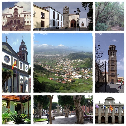
San Cristóbal de La Laguna
Spain · 28.4853° N, 16.3167° W · 1 km² · 7 km from Santa Cruz de Tenerife
San Cristóbal de La Laguna (commonly known as La Laguna, Spanish pronunciation: [saŋ kɾisˈtoβal de la laˈɣuna]) is a city and municipality in the northern part of the island of Tenerife in the Province of Santa Cruz de Tenerife, on the Canary Islands, Spain. The former capital of the Canary Islands, the city is the third-most populous city of the archipelago and the second-most populous city of the island.
In 1999 the historical center of La Laguna was declared a World Heritage Site by UNESCO, after being nominated by Spain. La Laguna is situated alongside the city of Santa Cruz de Tenerife; thus, the two cities and municipalities form a single large urban center. Its economy is business-oriented while agriculture dominates the northeastern portion of the city. The urban area dominates the central and the southern parts.
La Laguna is considered to be the cultural capital of the Canary Islands. It holds the incorrupt body of Sor María de Jesús, and the Christ of La Laguna (Cristo de La Laguna).
A landmark of the city is the Cathedral of La Laguna, which is the Catholic cathedral of Tenerife and its diocese (Diocese of Tenerife).
Adapted from Wikipedia: San Cristóbal de La Laguna (CC BY-SA 4.0).
Why San Cristóbal de La Laguna Is Listed
- (ii)
- An important interchange of human values.
- (iv)
- An outstanding example of a type of building or landscape.
More about San Cristóbal de La Laguna
UNESCO's Description
San Cristóbal de La Laguna, in the Canary Islands, has two nuclei: the original, unplanned Upper Town; and the Lower Town, the first ideal 'city-territory' laid out according to philosophical principles. Its wide streets and open spaces have a number of fine churches and public and private buildings dating from the 16th to the 18th century.
From the UNESCO World Heritage Centre (CC BY-SA IGO 3.0).
Climate
Because it captures moisture from the prevailing northeasterly winds, San Cristóbal de La Laguna has a Mediterranean climate (Köppen: Csb) that contrasts with the arid climate of other cities on the Canary Islands. It receives three to five times more rainfall than falls on the southern slopes, around ten percent less sunshine, and about ten percent higher humidity throughout the year. In spite of its elevation, the maritime and subtropical influences keep the temperature above frost at all times.
History
The land upon which the city now stands belonged to the Menceyato de Anaga, which was one of nine aboriginal Guanche kingdoms on the island until its conquest by the Kingdom of Castile. The valley of Aguere (where the city lies) and especially the large lake that was in this place, was a place of pilgrimage for the aborigines of the island.
The Battle of Aguere was fought in the city in 1494. The city was founded between 1496 and 1497 by Alonso Fernández de Lugo and became the capital of the island of Tenerife after the conclusion of the conquest of the islands. Later the city became the capital of all of the Canary Islands. In 1582, the city suffered an epidemic of plague that resulted in between 5,000 and 9,000 deaths.
Sections adapted from Wikipedia: San Cristóbal de La Laguna (CC BY-SA 4.0).
Key Facts
| Established | 1496 |
|---|---|
| Area | 102 km² |
Facts from Wikidata Q54898 (CC0).
Visiting San Cristóbal de La Laguna
San Cristóbal de La Laguna, informally known as La Laguna, is a city in Tenerife. It is the oldest city on the island and has a well-preserved city centre, and in 1999 was designated a UNESCO World Heritage Site. Its elevation is considerably higher than Santa Cruz de Tenerife, making it noticeably cooler than other nearby settlements.
Travel notes adapted from Wikivoyage: San Cristóbal de La Laguna (CC BY-SA 4.0).

Atapuerca
Spain · 42.3501° N, 3.5195° W · 3 km² · 13 km from Burgos
The archaeological site of Atapuerca is located in the Province of Burgos in the north of Spain and is notable for its evidence of early human occupation. Bone fragments from around 800,000 years ago, found in its Gran Dolina cavern, provide the oldest known evidence of hominid settlement in Western Europe and of hominid cannibalism anywhere in the world.
It was designated a World Heritage Site in 2000.
Adapted from Wikipedia: Archaeological site of Atapuerca (CC BY-SA 4.0).
Why Atapuerca Is Listed
- (iii)
- A unique testimony to a cultural tradition or civilisation.
- (v)
- An outstanding example of traditional human settlement or land use.
More about Atapuerca
UNESCO's Description
The caves of the Sierra de Atapuerca contain a rich fossil record of the earliest human beings in Europe, from nearly one million years ago and extending up to the Common Era. They represent an exceptional reserve of data, the scientific study of which provides priceless information about the appearance and the way of life of these remote human ancestors.
From the UNESCO World Heritage Centre (CC BY-SA IGO 3.0).

Catalan Romanesque Churches of the Vall de Boí
Spain · 42.5047° N, 0.8036° E · 58 km from Andorra
The Churches of the Vall de Boí are a set of nine Early Romanesque churches declared World Heritage Site by UNESCO and located in the Vall de Boí, in the Catalan comarca of Alta Ribagorça (Province of Lleida).
Built between the 11th and 12th centuries, as a group, these churches represent an especially pure and consistent example of pictorial art and architecture in the Lombard Romanesque style and were unusual for the richness of their interior paintings. They are the largest concentration in Europe of Romanesque art and a unique example of 12th century Catalonian cultural traditions.
In the early 20th century, a major effort to study the interior pictorial decoration was undertaken, resulting in their protection in law and their removal to the National Museum of Catalan Art (MNAC) in Barcelona and replacing them with in-situ reproductions.
Adapted from Wikipedia: Catalan Romanesque Churches of the Vall de Boí (CC BY-SA 4.0).
Why Catalan Romanesque Churches of the Vall de Boí Is Listed
- (ii)
- An important interchange of human values.
- (iv)
- An outstanding example of a type of building or landscape.
More about Catalan Romanesque Churches of the Vall de Boí
UNESCO's Description
The narrow Vall de Boí is situated in the high Pyrénées, in the Alta Ribagorça region and is surrounded by steep mountains. Each village in the valley contains a Romanesque church, and is surrounded by a pattern of enclosed fields. There are extensive seasonally-used grazing lands on the higher slopes.
From the UNESCO World Heritage Centre (CC BY-SA IGO 3.0).
History of the frescoes of the Vall de Boí
The twelfth century was the golden age for fresco painting throughout Catalonia; the rise of military orders and victories against the Moors led to increased wealth.
The churches in the Vall de Boí were built in two stages: those of Boí around 1100 and in style are connected to Aquitaine. The second stage, the churches of Taüll, date from 1123 that reflect a Lombard style mixed with the sculpture from Toulouse. The apse of Sant Climent de Taüll is considered a masterpiece of European Romanesque painting.
During the early 20th century there was a major effort to study and catalog and eventually to purchase, remove and transfer the Romanesque wall paintings in the churches of the Vall de Boí area. This activity was driven by both the academic interests of scholars, and by art dealers.
Sections adapted from Wikipedia: Catalan Romanesque Churches of the Vall de Boí (CC BY-SA 4.0).
Key Facts
| Area | 0.1 km² |
|---|---|
| Architectural style | Romanesque architecture |
Facts from Wikidata Q1091515 (CC0).

Colonia Iulia Urbs Triumphalis Tarraco
Spain · 41.1165° N, 1.2552° E · 1 km from Tarragona
Tarraco is the ancient name of the current city of Tarragona (Catalonia, Spain). It was the oldest Roman settlement on the Iberian Peninsula. It became the capital of Hispania Tarraconensis following the latter's creation during the Roman Empire.
In 2000, the archaeological ensemble of Tarraco was declared a World Heritage Site by UNESCO.
Adapted from Wikipedia: Tarraco (CC BY-SA 4.0).
Why Colonia Iulia Urbs Triumphalis Tarraco Is Listed
- (ii)
- An important interchange of human values.
- (iii)
- A unique testimony to a cultural tradition or civilisation.
More about Colonia Iulia Urbs Triumphalis Tarraco
UNESCO's Description
Tarraco (modern-day Tarragona) was a major administrative and mercantile city in Roman Spain and the centre of the Imperial cult for all the Iberian provinces. It was endowed with many fine buildings, and parts of these have been revealed in a series of exceptional excavations. Although most of the remains are fragmentary, many preserved beneath more recent buildings, they present a vivid picture of the grandeur of this Roman provincial capital.
From the UNESCO World Heritage Centre (CC BY-SA IGO 3.0).
History
The area was inhabited from the 5th century BC by Iberians, mainly in the Ebro Valley, who had commercial contacts with the Greeks and Phoenicians settled on the coast.
Tarraco is first mentioned after the arrival of Gnaeus Cornelius Scipio Calvus at Empúries in 218 BC at the start of the Second Punic War which began the Roman conquest of Hispania. The Romans conquered a field of Punic supplies for Hannibal's troops near Cissis and took the city. A short time later, the Romans were attacked "not far from Tarraco". Cissis and Tarraco may have been the same city. Cissis may be equated with Kesse, the name on coins of Iberian origin from the 1st and 2nd century BC that were marked according to Roman weight standards.
Sections adapted from Wikipedia: Tarraco (CC BY-SA 4.0).

Palmeral of Elche
Spain · 38.2644° N, 0.6908° W · 1 km² · 20 km from Alicante
The Palmeral or Palm Grove of Elche (Spanish: Palmeral de Elche; Valencian: Palmerar d'Elx) is the generic name for a system of date palm orchards in the city of Elche, Spain.
The Palmeral was planted in Roman times and underwent modifications in the medieval period under Islamic and Christian rulers. The Roman empire introduced water management techniques to Elche, but the 10th c. Islamic Caliphate of Córdoba and later rulers of Al-Andalus planted palm groves and garden-estates in huertos (rectangular base agricultural units). Islamic rulers also constructed the largest canal system sections in Elche. In the 13th century Christian rulers conquered Elche and expanded the canal system. Industrialization and urban sprawl contracted the Palmeral in the late 19th and 20th century. The Spanish national government and Valencian regional government enacted legislation to protect the Palm Grove. In 2000, UNESCO designated the Palmeral a World Heritage Site, but climate change, pests, and disease threaten the site. The Palmeral includes a National Artistic Garden, Palm Grove Museum, Route of El Palmeral, and Municipal Park.
Adapted from Wikipedia: Palmeral of Elche (CC BY-SA 4.0).
Why Palmeral of Elche Is Listed
- (ii)
- An important interchange of human values.
- (v)
- An outstanding example of traditional human settlement or land use.
More about Palmeral of Elche
UNESCO's Description
The Palmeral of Elche, a landscape of groves of date palms, was formally laid out, with elaborate irrigation systems, at the time the Muslim city of Elche was erected, towards the end of the tenth century A.C., when much of the Iberian peninsula was Arab. The Palmeral is an oasis, a system for agrarian production in arid areas. It is also a unique example of Arab agricultural practices on the European continent. Cultivation of date palms in Elche is known at least since the Iberian times, dating around the fifth century B.C.
From the UNESCO World Heritage Centre (CC BY-SA IGO 3.0).
History
In the 5th century BCE, Carthaginian settlers in the town of Ilici planted the first date palms of Elche. After Rome’s conquest of the Iberian peninsula in the 2nd century BCE, Roman settlers introduced the first elaborate forms of agricultural water management. To irrigate their cereal and olive tree crop fields, the Romans constructed a dam at the Vinalopó River bed in the mountains north of Elche. Aqueducts then channeled the dam water to Elche.
In the 10th century CE, the Caliphate of Córdoba moved the city of Elche seven km away from Ilici to its present location. The Caliphate from the 7th to 10th century expanded the irrigation system into a complicated canal system centered on the Vinalopó river.
Sections adapted from Wikipedia: Palmeral of Elche (CC BY-SA 4.0).

Roman Walls of Lugo
Spain · 43.0142° N, 7.5599° W · 78 km from La Coruña
The Roman walls of Lugo are the ancient Roman defensive walls of the Roman colonia of Lucus Augusti –present-day Lugo, Spain–, in the Roman province of Hispania Tarraconensis. Stretching 2,120 metres (6,960 ft), they were built in the third century AD to defend the ancient Roman town. The fortifications, still largely intact, were declared a UNESCO World Heritage Site in 2000 and are a popular tourist attraction.
Adapted from Wikipedia: Roman walls of Lugo (CC BY-SA 4.0).
Why Roman Walls of Lugo Is Listed
- (iv)
- An outstanding example of a type of building or landscape.
More about Roman Walls of Lugo
UNESCO's Description
The walls of Lugo were built in the later part of the 3rd century to defend the Roman town of Lucus. The entire circuit survives intact and is the finest example of late Roman fortifications in western Europe.
From the UNESCO World Heritage Centre (CC BY-SA IGO 3.0).
History
During the Middle Ages, pilgrims passed through the gates of the Lugo walls, particularly Porta Miña, on their way to Santiago de Compostela.
The fortifications were added to UNESCO's World Heritage List in late 2000 as "the finest example of late Roman fortifications in western Europe." The walls have held Spanish monument status (Bien de Interés Cultural) since 1921. In 2007 the walls were twinned with the Great Wall of China during a ceremony attended by China's then-ambassador to Spain, Qiu Xiaoqi.
A walkway over the walls now allows visitors to stroll along the entire length. The town also has a visitor's centre dedicated to the walls, the Centro de Interpretación da Muralla.
Description
The city walls were built between 263 and 276 A.D. to defend the Roman town of Lucus Augusti (present-day Lugo) against local tribesmen and Germanic invaders. The walls formed part of a complex of fortifications which also included a moat and an intervallum (the clearing between the walls and the city). The entire length of the walls is around 2,120 metres (6,960 ft), enclosing an area of 34.4 hectares (85 acres). Not all of the town was enclosed by walls: much of the southeastern part of the town remained unprotected, while in other places unused areas were enclosed by walls.
The width of the walls is around 4.2 metres (14 ft) and their height varies between 8 metres (26 ft) and 12 metres (39 ft).
Sections adapted from Wikipedia: Roman walls of Lugo (CC BY-SA 4.0).

Aranjuez Cultural Landscape
Spain · 40.0364° N, 3.6093° W · 20 km² · 40 km from Toledo
The Aranjuez cultural landscape is an entity of complex relationships: between nature and human activity, between sinuous watercourses and geometric landscape design, between the rural and the urban, between forest landscape and the delicately modulated architecture of its palatial buildings. Three hundred years of royal attention to the development and care of this landscape have seen it express an evolution of concepts from humanism and political centralization, to characteristics such as those found in its 18th century French-style Baroque garden, to the urban lifestyle which developed alongside the sciences of plant acclimatization and stock-breeding during the Age of Enlightenment.
Description from the UNESCO World Heritage Centre (CC BY-SA IGO 3.0).
Why Aranjuez Cultural Landscape Is Listed
- (ii)
- An important interchange of human values.
- (iv)
- An outstanding example of a type of building or landscape.

Renaissance Monumental Ensembles of Úbeda and Baeza
Spain · 38.0113° N, 3.3712° W · 24 km from Linares
The urban morphology of the two small cities of Úbeda and Baeza in southern Spain dates back to the Moorish 9th century and to the Reconquista in the 13th century. An important development took place in the 16th century, when the cities were subject to renovation along the lines of the emerging Renaissance. This planning intervention was part of the introduction into Spain of new humanistic ideas from Italy, which went on to have a great influence on the architecture of Latin America.
Description from the UNESCO World Heritage Centre (CC BY-SA IGO 3.0).
Why Renaissance Monumental Ensembles of Úbeda and Baeza Is Listed
- (i)
- A masterpiece of human creative genius.
- (ii)
- An important interchange of human values.
- (iv)
- An outstanding example of a type of building or landscape.

Vizcaya Bridge
Spain · 43.3231° N, 3.0169° W · 11 km from Bilbao
The Vizcaya Bridge (Bizkaiko Zubia in Basque, Puente de Vizcaya in Spanish) is a transporter bridge that links the towns of Portugalete and Las Arenas (part of Getxo) in the Biscay province of Spain, crossing the mouth of the Nervión River.
People in the area, and even the official website, commonly call it the Puente Colgante (literally "hanging bridge", used for suspension bridge in Spanish), although its structure is quite different from a suspension bridge.
Adapted from Wikipedia: Vizcaya Bridge (CC BY-SA 4.0).
Why Vizcaya Bridge Is Listed
- (i)
- A masterpiece of human creative genius.
- (ii)
- An important interchange of human values.
More about Vizcaya Bridge
UNESCO's Description
Vizcaya Bridge straddles the mouth of the Ibaizabal estuary, west of Bilbao. It was designed by the Basque architect Alberto de Palacio and completed in 1893. The 45-m-high bridge with its span of 160 m, merges 19th-century ironworking traditions with the then new lightweight technology of twisted steel ropes. It was the first bridge in the world to carry people and traffic on a high suspended gondola and was used as a model for many similar bridges in Europe, Africa and the America only a few of which survive. With its innovative use of lightweight twisted steel cables, it is regarded as one of the outstanding architectural iron constructions of the Industrial Revolution.
From the UNESCO World Heritage Centre (CC BY-SA IGO 3.0).
History
The Vizcaya Bridge was built to connect the two banks which are situated at the mouth of the Nervion River. It is the world's oldest transporter bridge and was built in 1893, designed by Alberto Palacio, one of Gustave Eiffel's disciples. The engineer Ferdinand Joseph Arnodin was in charge, and the main financier of the project was Santos Lopez de Letona. Arnodin provided a solution to the problem of connecting the towns of Portugalete and Getxo without disrupting the maritime traffic of the Port of Bilbao, and without having to build a massive structure with long ramps. Palacio wanted to design a bridge that could transport passengers and cargo, and that could allow ships to go through. Palacio's shuttle bridge was adequate and could be built for a reasonable price.
Sections adapted from Wikipedia: Vizcaya Bridge (CC BY-SA 4.0).

Teide National Park
Spain · 28.2647° N, 16.6181° W · 190 km² · 43 km from Santa Cruz de Tenerife
Teide National Park (Spanish: Parque nacional del Teide, pronounced [ˈpaɾke naθjoˈnal del ˈtejðe]) is a national park located in Tenerife, Canary Islands, Spain.
The national park is centered on Mount Teide, the highest mountain of Spain (3,718 meters high) in addition, the highest volcano in the Atlantic Ocean islands and the third highest volcano in the world from its base in the ocean floor (7.500 meters high). Pico Viejo, also included within the national park limits, is the second highest volcano in the Canary Islands with its 3,135 m peak. Mount Teide and Pico Viejo are the only two peaks in the Canary islands rising above the 3,000 m level.
The park has an area of 18,990 hectares located in the municipality of La Orotava. It was named a World Heritage Site by UNESCO on June 28, 2007. Since the end of 2007, it has also been one of the 12 Treasures of Spain. On a ridge, to the east of Teide, are the telescopes of the Observatorio del Teide.
Teide is the most-visited national park in Spain. with some 3 million visitors yearly. In 2016, Teide received 4,079,823 visitors, reaching a historical record.
Adapted from Wikipedia: Teide National Park (CC BY-SA 4.0).
Why Teide National Park Is Listed
- (vii)
- Superlative natural phenomena or exceptional natural beauty.
- (viii)
- An outstanding example of major stages of the Earth's history.
More about Teide National Park
UNESCO's Description
Situated on the island of Tenerife, Teide National Park features the Teide-Pico Viejo stratovolcano that, at 3,718 m, is the highest peak on Spanish soil. Rising 7,500 m above the ocean floor, it is regarded as the world’s third-tallest volcanic structure and stands in a spectacular environment. The visual impact of the site is all the greater due to atmospheric conditions that create constantly changing textures and tones in the landscape and a ‘sea of clouds’ that forms a visually impressive backdrop to the mountain. Teide is of global importance in providing evidence of the geological processes that underpin the evolution of oceanic islands.
From the UNESCO World Heritage Centre (CC BY-SA IGO 3.0).
Geography and climate
The Teide National Park has generally a very sunny, dry and mild climate. The major climates found in the Teide National Park are the Mediterranean climate (Csa/Csb) and the Semi-arid climate (BSk).
The Izaña Teide Observatory located at 2,371 metres (7,779 ft) asl registers an annual temperature of 10.2 °C (50.4 °F) and almost 3,500 sunshine hours annually. Most summer days have completely clear skies.
History
Teide National Park held spiritual significance to aboriginal Guanches, and important archaeological sites have been discovered in the park. Teide was a place of worship for the Guanches, who believed it was the gate to hell (Echeyde).
National park status was declared on January 22, 1954. In 1989, the Council of Europe awarded the European Diploma of Protected Areas, its highest category. This recognition and conservation management has been subsequently renewed in 1994, 1999 and 2004. In 2007, UNESCO declared Teide National Park a World Heritage Site. At the end of 2007, participants in the 12 Treasures of Spain project voted to include Teide National Park as the sixth treasure of Spain.
Sections adapted from Wikipedia: Teide National Park (CC BY-SA 4.0).
Key Facts
| Established | 22 January 1954 |
|---|---|
| Area | 190 km² |
Facts from Wikidata Q715124 (CC0).
Visiting Teide National Park
Teide National Park (Spanish: Parque Nacional del Teide) is Europe's most visited national park with over 4 million visitors in 2016. With an area of 190 km² it occupies the highest 10% of Tenerife's land area, one of the Canary Islands which administratively belong to Spain. It was declared a UNESCO World Heritage Site in 2007 and has since been one of the 12 Treasures of Spain.
The park is known for its 2 volcanoes, 1 El Teide (3,715 m) and 2 Pico Viejo (3,135 m), the only peaks on the Canary Islands above 3,000 m above sea level.
Travel notes adapted from Wikivoyage: Teide National Park (CC BY-SA 4.0).

Tower of Hercules
Spain · 43.3858° N, 8.4064° W · 1 km² · 6 km from La Coruña
The Tower of Hercules (Galician: Torre de Hércules, Spanish: Torre de Hércules) is an ancient Roman lighthouse in A Coruña, Galicia, Spain, overlooking the Atlantic coast. It is the only fully preserved Roman lighthouse still used for maritime signalling. Built in the late 1st century, the tower is located on a peninsula about 2.4 km (1.5 mi) from the centre of A Coruña, Galicia, in northwestern Spain. Until the 20th century, it was known as the Farum Brigantium. The Latin word farum is derived from the Greek Φάρος, Pharos, for the Lighthouse of Alexandria in Egypt. The tower was renovated in the 18th century and stands 55 metres (180 ft) tall, comprising 34 metres (112 ft) of surviving Roman masonry and 21 metres (69 ft) added during the restoration.
There is a sculpture garden on the grounds of the lighthouse featuring works by Pablo Serrano and Francisco Leiro. The Tower of Hercules is a National Monument of Spain and has been a UNESCO World Heritage Site since 27 June 2009. It is the second-tallest lighthouse in Spain, after the Faro de Chipiona.
Adapted from Wikipedia: Tower of Hercules (CC BY-SA 4.0).
Why Tower of Hercules Is Listed
- (iii)
- A unique testimony to a cultural tradition or civilisation.
More about Tower of Hercules
UNESCO's Description
The Tower of Hercules has served as a lighthouse and landmark at the entrance of La Coruña harbour in north-western Spain since the late 1st century A.D. when the Romans built the Farum Brigantium. The Tower, built on a 57 metre high rock, rises a further 55 metres, of which 34 metres correspond to the Roman masonry and 21 meters to the restoration directed by architect Eustaquio Giannini in the 18 th century, who augmented the Roman core with two octagonal forms. Immediately adjacent to the base of the Tower, is a small rectangular Roman building. The site also features a sculpture park, the Monte dos Bicos rock carvings from the Iron Age and a Muslim cemetery. The Roman foundations of the building were revealed in excavations conducted in the 1990s. Many legends from the Middle Ages to the 19th century surround the Tower of Hercules, which is unique as it is the only lighthouse of Greco-Roman antiquity to have retained a measure of structural integrity and functional continuity.
From the UNESCO World Heritage Centre (CC BY-SA IGO 3.0).
Construction and history
The tower is known to have existed by the 1st century. It was built (or perhaps rebuilt) by the Emperor Trajan, possibly on foundations following a design that was Phoenician in origin. The design was based on the original plans of the Lighthouse of Alexandria. Its base preserves a cornerstone with the inscription MARTI AVG.SACR C.SEVIVS LVPVS ARCHITECTVS ÆMINIENSIS LVSITANVS.EX.VO, ascribing the tower's design to the architect Gaius Sevius Lupus, from Aeminium (present-day Coimbra, Portugal) in the former province of Lusitania, as an offering to the Roman god of war, Mars. The original tower was shorter and wider than the current tower, as the surviving core was surrounded by a spiral ramp. The outline of this ramp is still visible in the restored exterior.
Sections adapted from Wikipedia: Tower of Hercules (CC BY-SA 4.0).
Key Facts
| Established | 1st century |
|---|---|
| Area | 0.7 km² |
| Architectural style | ancient Roman architecture |
Facts from Wikidata Q245151 (CC0).

Prehistoric Rock-Art Site of the Côa Valley and Siega Verde
Spain, Portugal · 40.6975° N, 6.6611° W · 54 km from Guarda
The two Prehistoric Rock Art Sites in the Côa Valley (Portugal) and Siega Verde (Spain) are located on the banks of the rivers Agueda and Côa, tributaries of the river Douro, documenting continuous human occupation from the end of the Paleolithic Age. Hundreds of panels with thousands of animal figures (5,000 in Foz Côa and around 440 in Siega Verde) were carved over several millennia, representing the most remarkable open-air ensemble of Paleolithic art on the Iberian Peninsula. Côa Valley and Siega Verde provide the best illustration of the iconographic themes and organization of Paleolithic rock art, using the same modes of expression in caves and in the open air, thus contributing to a greater understanding of this artistic phenomenon. Together they form a unique site of the prehistoric era, rich in material evidence of Upper Paleolithic occupation.
Description from the UNESCO World Heritage Centre (CC BY-SA IGO 3.0).
Why Prehistoric Rock-Art Site of the Côa Valley and Siega Verde Is Listed
- (i)
- A masterpiece of human creative genius.
- (iii)
- A unique testimony to a cultural tradition or civilisation.

Cultural Landscape of the Serra de Tramuntana
Spain · 39.7308° N, 2.6947° E · 307 km² · 18 km from Palma
The Cultural Landscape of the Serra de Tramuntana located on a sheer-sided mountain range parallel to the north-western coast of the island of Mallorca. Millennia of agriculture in an environment with scarce resources has transformed the terrain and displays an articulated network of devices for the management of water revolving around farming units of feudal origins. The landscape is marked by agricultural terraces and inter-connected water works - including water mills - as well as dry stone constructions and farms.
Description from the UNESCO World Heritage Centre (CC BY-SA IGO 3.0).
Why Cultural Landscape of the Serra de Tramuntana Is Listed
- (ii)
- An important interchange of human values.
- (iv)
- An outstanding example of a type of building or landscape.
- (v)
- An outstanding example of traditional human settlement or land use.

Heritage of Mercury. Almadén and Idrija
Spain, Slovenia · 46.0039° N, 14.0267° E · 1 km² · 38 km from Ljubljana
The property includes the mining sites of Almadén (Spain), where mercury (quicksilver) has been extracted since antiquity, and Idrija (Slovenia), where mercury was first found in AD1490. The Spanish property includes buildings relating to its mining history, including Retamar Castle, religious buildings and traditional dwellings. The site in Idrija notably features mercury stores and infrastructure, as well as miners’ living quarters, and a miners’ theatre. The sites bear testimony to the intercontinental trade in mercury which generated important exchanges between Europe and America over the centuries. Together they represent the two largest mercury mines in the world, operational until recent times.
Description from the UNESCO World Heritage Centre (CC BY-SA IGO 3.0).
Why Heritage of Mercury. Almadén and Idrija Is Listed
- (ii)
- An important interchange of human values.
- (iv)
- An outstanding example of a type of building or landscape.

Antequera Dolmens Site
Spain · 37.0233° N, 4.5481° W · 24 km² · 36 km from Málaga
The Antequera Dolmens Site is a cultural heritage ensemble comprising three cultural monuments (the Dolmen of Menga, Dolmen of Viera and Tholos of El Romeral) and 2 natural mountain features (the Peña de los Enamorados and El Torcal) in and near the city of Antequera in Andalusia, Spain. The cultural institution responsible for its protection is the CADA (Conjunto Arqueológico Dólmenes de Antequera, Archeological Ensemble Dolmens of Antequera). It was declared a World Heritage Site in 2016.
Adapted from Wikipedia: Antequera Dolmens Site (CC BY-SA 4.0).
Why Antequera Dolmens Site Is Listed
- (i)
- A masterpiece of human creative genius.
- (iii)
- A unique testimony to a cultural tradition or civilisation.
- (iv)
- An outstanding example of a type of building or landscape.
More about Antequera Dolmens Site
UNESCO's Description
Located at the heart of Andalusia in southern Spain, the site comprises three megalithic monuments: the Menga and Viera dolmens and the Tholos of El Romeral, and two natural monuments: La Peña de los Enamorados and El Torcal mountainous formations, which are landmarks within the property. Built during the Neolithic and Bronze Age out of large stone blocks, these monuments form chambers with lintelled roofs or false cupolas. These three tombs, buried beneath their original earth tumuli, are one of the most remarkable architectural works of European prehistory and one of the most important examples of European Megalithism.
From the UNESCO World Heritage Centre (CC BY-SA IGO 3.0).
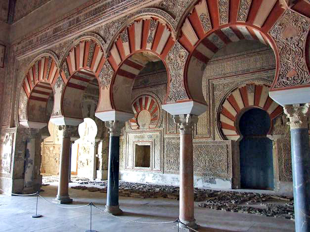
Madinat Al-Zahra
Spain · 37.8861° N, 4.8678° W · 1 km² · 9 km from Córdoba
Madinat al-Zahra or Medina Azahara (Arabic: مدينة الزهراء, romanized: Madīnat az-Zahrāʾ, lit. 'the radiant city') was a fortified palace-city on the western outskirts of Córdoba in present-day Spain. Its remains are a major archaeological site today. The city was built in the 10th century by Abd ar-Rahman III (912–961), a member of the Umayyad dynasty and the first caliph of Al-Andalus. It served as the capital of the Caliphate of Córdoba and its center of government.
The main reason for its construction was politico-ideological: Abd ar-Rahman III had declared himself "caliph" in 929 and the dignity of this new title required the establishment of a new city, a symbol of his power, imitating eastern caliphates. It sought to demonstrate his superiority over his great rivals, the Fatimid Caliphs of Ifriqiya in North Africa and the Abbasid Caliphs in Baghdad. The city was built near Córdoba, the existing capital of al-Andalus under Umayyad rule. Construction began in 936–940 and continued in multiple phases throughout his reign and the reign of his son, Al-Hakam II (r. 961–976).
Adapted from Wikipedia: Madinat al-Zahra (CC BY-SA 4.0).
Why Madinat Al-Zahra Is Listed
- (iii)
- A unique testimony to a cultural tradition or civilisation.
- (iv)
- An outstanding example of a type of building or landscape.
More about Madinat Al-Zahra
UNESCO's Description
The Caliphate city of Medina Azahara is an archaeological site of a city built in the mid-10th century CE by the Umayyad dynasty as the seat of the Caliphate of Cordoba. After prospering for several years, it was laid to waste during the civil war that put an end to the Caliphate in 1009-1010. The remains of the city were forgotten for almost 1,000 years until their rediscovery in the early 20th century. This complete urban ensemble features infrastructure such as roads, bridges, water systems, buildings, decorative elements and everyday objects. It provides in-depth knowledge of the now vanished Western Islamic civilization of Al-Andalus, at the height of its splendour.
From the UNESCO World Heritage Centre (CC BY-SA IGO 3.0).
Geography
Located 4 miles (6.4 km) west of Córdoba in the foothills of the Sierra Morena, oriented north-to-south on the slopes of Jabal al-Arus (meaning Bride Hill), and facing the valley of the Guadalquivir river, is Madinat az-Zahra, billed as the Versailles of the Middle Ages. It was chosen for its outstanding landscape values, allowing a hierarchical construction program so the city and the plains beyond its feet were physically and visually dominated by the buildings of the Alcázar (citadel).
There was also a quarry of limestone, used for the primary construction, though other stones from an area 50 km around were also used. The city's construction led to a road, water and supply infrastructure partly preserved until today in the form of remains of roads, quarries, aqueducts and bridges.
History
Abd ar-Rahman III was a member of the Umayyad dynasty, which had formerly ruled the Islamic world as head of the Umayyad Caliphate. The title "caliph" signified the political and spiritual leader of the whole Muslim world. In 750 the Umayyads were overthrown by the Abbasids, who took on the title of caliphs and established a new capital at Baghdad. In 756 Abd ar Rahman III's ancestor, Abd ar-Rahman I, managed to re-establish the dynasty's power in the Iberian Peninsula in the far western part of the Muslim world, known as Al-Andalus. Although independent from the Abbasids, the new Umayyad rulers in Al-Andalus, based in Córdoba, did not reclaim the title of "caliph" at this time.
Sections adapted from Wikipedia: Madinat al-Zahra (CC BY-SA 4.0).

Risco Caido
Spain · 28.0436° N, 15.6613° W · 94 km² · 24 km from Las Palmas
Risco Caído is a land-form and archaeological site on the island of Gran Canaria, Spain. The site contains prehistoric cave dwellings, temples, and granaries attributed to the pre-Hispanic culture of the Canary Islands. It is also considered to have been used as an astronomical observatory by Aboriginal people. In July 2019, Risco Caído was named as a UNESCO World Heritage Site. It is also a UNESCO recognised Cultural Landscape. It is the first World Heritage Site of the island of Gran Canaria and the province of Las Palmas and the fourth of the Canary Islands.
Adapted from Wikipedia: Risco Caído (CC BY-SA 4.0).
Why Risco Caido Is Listed
- (iii)
- A unique testimony to a cultural tradition or civilisation.
- (v)
- An outstanding example of traditional human settlement or land use.
More about Risco Caido
UNESCO's Description
Located in a vast mountainous area in the centre of Gran Canaria, Risco Caído comprises cliffs, ravines and volcanic formations in a landscape of rich biodiversity. The landscape includes a large number of troglodyte settlements — habitats, granaries and cisterns — whose age is proof of the presence of a pre-Hispanic culture on the island, which has evolved in isolation, from the arrival of North African Berbers, around the beginning of our era, until the first Spanish settlers in the 15th century. The troglodyte complex also includes cult cavities and two sacred temples, or almogarenes — Risco Caído and Roque Bentayga — where seasonal ceremonies were held. These temples are thought to be linked to a possible cult of the stars and Mother Earth.
From the UNESCO World Heritage Centre (CC BY-SA IGO 3.0).
Description
Located in a vast mountainous area in the centre of Gran Canaria, Risco Caído comprises cliffs, ravines and volcanic formations in a landscape of rich biodiversity. The landscape includes a large number of troglodyte (cave-dwelling) habitats, granaries and cisterns whose age is proof of the presence of a pre-Hispanic culture on the island, which evolved in isolation from the arrival of North African Berbers, around the beginning of our era, until the first Spanish settlers in the 15th century. The troglodyte complex also includes cult cavities and two sacred temples or almogarenes, Risco Caído and Roque Bentayga, where seasonal ceremonies were held. These temples are thought to be linked to a possible cult of the stars and Mother Earth.
Sections adapted from Wikipedia: Risco Caído (CC BY-SA 4.0).

Paseo del Prado and Buen Retiro, a landscape of Arts and Sciences
Spain · 40.4141° N, 3.6865° W · 2 km² · 1 km from Madrid
Located at the urban heart of Madrid, this cultural landscape evolved since the creation of the tree-lined Paseo del Prado avenue, a prototype of the Hispanic alameda, in the 16th century. The avenue features major fountains, notably the Fuente de Apolo and the Fuente de Neptuno, and the Fuente de Cibeles, an iconic symbol of the city, surrounded by prestigious buildings. The site embodies a new idea of urban space and development from the enlightened absolutist period of the 18th century. Buildings dedicated to the arts and sciences join others in the site that are devoted to industry, healthcare and research. Collectively, they illustrate the aspiration for a utopian society during the height of the Spanish Empire, linked to the enlightened idea of democratization of knowledge, and exercised major influence in Latin America. The 120-hectare Jardines del Buen Retiro (Garden of Pleasant Retreat), a remnant of the 17th-century Buen Retiro Palace, constitutes the largest part of the property. The site also houses the terraced Royal Botanical Garden and the largely residential neighbourhood of Barrio Jerónimos with its rich variety of 19th- and 20th-century buildings that include cultural and scientific venues.
Description from the UNESCO World Heritage Centre (CC BY-SA IGO 3.0).
Why Paseo del Prado and Buen Retiro, a landscape of Arts and Sciences Is Listed
- (ii)
- An important interchange of human values.
- (iv)
- An outstanding example of a type of building or landscape.
- (vi)
- A direct association with events, ideas or beliefs of universal significance.
Talayotic Culture of Minorca
Spain · 39.9975° N, 3.9089° E · 35 km² · 117 km from Palma
Located on the island of Menorca in the western Mediterranean Sea, these archaeological sites are situated in agro-pastoral landscapes. A testimony to the occupation of the island by prehistoric communities, these sites display a diversity of prehistoric settlements and burial places. The materials, forms and locations of structures dating from the Bronze Age (1600 BCE) to the Late Iron Age (123 BCE) show the evolution of a “cyclopean” architecture built with very large blocks of stone. Astronomical orientations and visual interconnections between prehistoric structures indicate networks with possible cosmological meanings.
Description from the UNESCO World Heritage Centre (CC BY-SA IGO 3.0).
Why Talayotic Culture of Minorca Is Listed
- (i)
- A masterpiece of human creative genius.
- (ii)
- An important interchange of human values.
- (iv)
- An outstanding example of a type of building or landscape.
Shared With Neighbouring Countries
These sites cross the border. Each is written up on the page of the country UNESCO lists first.

World Heritage in Spain: Quick Answers
- How many UNESCO World Heritage Sites are in Spain?
- Spain has 49 World Heritage Sites: 44 cultural, 4 natural and 1 mixed. 1 of them is shared with a neighbouring country.
- What was the first World Heritage Site in Spain?
- Alhambra, Generalife and Albayzín, Granada, inscribed in 1984. The most recent is Talayotic Culture of Minorca, inscribed in 2023.
- What are the natural World Heritage Sites in Spain?
- Garajonay National Park, Doñana National Park, Pyrénées – Mont Perdu World Heritage Site (mixed), Ancient and Primeval Beech Forests of the Carpathians and Other Regions of Europe, Teide National Park.
- Are any World Heritage Sites in Spain in danger?
- None of the World Heritage Sites in Spain is on UNESCO's List of World Heritage in Danger.