
Map of Andorra
Andorra is a country in Europe with its capital at Andorra la Vella, home to about 82,904 people across 468 km². The interactive map below plots 1 cities and towns and 1 mountain summits recorded for Andorra in YearMaps.
- Population
- 82,904
- Area
- 468 km²
- Capital
- Andorra la Vella
- Continent
- Europe
Interactive Map of Andorra
Centred on Andorra la Vella at 42.5000° N, 1.5165° E. Use the layer panel to switch on rivers, dams, ports, peaks and historical borders.
About Andorra
Andorra, officially the Principality of Andorra, is a landlocked country on the Iberian Peninsula, in the eastern Pyrenees in southwestern Europe, bordered by France to the north and Spain to the south. Believed to have been created by Charlemagne, Andorra was ruled by the count of Urgell until 988, when it was transferred to the Diocese of Urgell. Andorra was formed as a polity by a charter in 1278, being a lordship within the Principality of Catalonia until 1715. It is currently headed by two co-princes: the Bishop of Urgell in Catalonia, Spain, and the president of France. Its capital and largest city is Andorra la Vella.
Andorra is the sixth-smallest state in Europe and the largest of the European microstates, with an area of 468 square kilometres (181 sq mi) and an estimated population of 90,021 as of July 2026. The Andorran people are a Romance group descended from the Catalans. Andorra is the world's 17th-smallest country by land and 11th-smallest by population. Its capital, Andorra la Vella, is the highest capital city in Europe, at an elevation of 1,023 metres (3,356 feet) above sea level. The sole official language is Catalan, while Spanish, Portuguese and French are also used.
Tourism in Andorra brings approximately 8 million visitors to the country annually. Andorra is not a member state of the European Union. It has been a member of the Council of Europe and of the United Nations since 1993.
Summary adapted from Wikipedia: Andorra (CC BY-SA 4.0).

Geography and Climate of Andorra
The landlocked Principality of Andorra -- one of the smallest states in Europe and nestled high in the Pyrenees between the French and Spanish borders -- is the last independent survivor of the Hispanic March states created by Frankish King Charlemagne in 795 after he halted the Moorish invasion of Spain. The March states were a series of buffer states to keep the Muslim Moors from advancing into Christian France. For 715 years, from 1278 to 1993, Andorrans lived under a unique co-principality, ruled by French and Spanish leaders (from 1607 onward, the French chief of state and the Bishop of Urgell). In 1993, this feudal system was modified with the introduction of a modern constitution; the co-princes remained as titular heads of state, but the government transformed into a parliamentary democracy. Andorra's winter sports, summer climate, and duty-free shopping attract approximately 8 million people each year. Andorra has also become a wealthy international commercial center because of its mature banking sector and low taxes. As part of the effort to modernize its economy, Andorra has opened to foreign investment and engaged in other reforms, such as tax initiatives aimed at supporting broader infrastructure. Although not a member of the EU, Andorra enjoys a special relationship with the bloc that is governed by various customs and cooperation agreements, and Andorra uses the euro as its national currency.
- Location
- Southwestern Europe, Pyrenees mountains, on the border between France and Spain.
- Climate
- Temperate; snowy, cold winters and warm, dry summers.
- Terrain
- Rugged mountains dissected by narrow valleys.
- Highest point
- Pic de Coma Pedrosa 2,946 m.
- Lowest point
- Riu Runer 840 m.
- Coastline
- 0 km (landlocked)
- Land borders
- Total: 118 km; border countries: France 55 km; Spain 63 km.
- Natural resources
- Hydropower, mineral water, timber, iron ore, lead.
- Land use
- Agricultural land: 39.9% (2023 est.); arable land: 1.6% (2023 est.); permanent crops: 0% (2023 est.); permanent pasture: 38.3% (2023 est.); forest: 38.7% (2023 est.); other: 21.4% (2023 est.)
- Natural hazards
- Avalanches.
- Geographic note
- Landlocked; straddles a number of important crossroads in the Pyrenees.
- Languages
- Catalan (official) 44.1%, Castilian 40.3%, Portuguese 13.5%, French 10%, English 3%, other 6.8% (2022 est.)
- Religions
- Christian (predominantly Roman Catholic) 89.5, other 8.8%, unaffiliated 1.7% (2020 est.)
- Ethnic groups
- Spanish 34.3%, Andorran 32.1%, Portuguese 10%, French 5.6%, other 18% (2024 est.)
- Economy
- High GDP; low unemployment; non-EU Euro user; co-principality duty-free area between Spain and France; tourist hub but hit hard by COVID-19; modern, non-tax haven financial sector; looking for big tech investments; new member of SEPA and IMF.
From the CIA World Factbook (public domain), archived edition of 2026-01-22. The Factbook is no longer updated, so figures reflect that edition.
Andorra in Numbers
- Population
- 82,904
- GDP
- US$4.5 billion
- GDP per person
- US$54,292
- Life expectancy
- 84.2 years
- Population growth
- 1.17% a year
- Population density
- 175 per km²
- Urban population
- 89.0%
- Surface area
- 468 km²
- Forest cover
- 38.9%
- Arable land
- 0.3%
- Access to electricity
- 100.0%
- Internet users
- 94.4%
Indicators from World Bank Open Data (CC BY 4.0). The year under each figure is its reference year.
Andorra in Depth
History
La Balma de la Margineda, found by archaeologists at Sant Julià de Lòria, was settled in 9500 BC as a passing place between the two sides of the Pyrenees. The seasonal camp was perfectly located for hunting and fishing by the groups of hunter-gatherers from Ariege and Segre.
During the Neolithic, a group of people moved to the Valley of Madriu (the present-day Natural Park located in Escaldes-Engordany declared UNESCO World Heritage Site) as a permanent camp in 6640 BC. The population of the valley grew cereals, raised domestic livestock, and developed commercial trade with people from Ségre and Occitania.
Other archaeological deposits include the Tombs of Segudet (Ordino) and Feixa del Moro (Sant Julià de Lòria), both dated in 4900–4300 BC as an example of the Urn culture in Andorra.
Geography
Andorra is a small landlocked country in the eastern Pyrenees mountain range, between France and Spain. It covers 468 km2 (181 sq mi), has an average elevation of 1,996 m (6,549 ft), and shares borders of 56.6 km (35.2 mi) with France and 63.7 km (39.6 mi) with Spain. Its terrain is predominantly mountainous; its highest point is Coma Pedrosa, at 2,942 m (9,652 ft), and its lowest is at the Riu Runer confluence, at 840 m (2,756 ft). The rivers Valira del Nord in the west and Valira d'Orient in the east flow through the country's two principal valleys and converge in Escaldes-Engordany to form the Gran Valira, Andorra's principal river. The population is concentrated mainly along the valley floors.
Economy
Tourism, the mainstay of Andorra's economy, accounts for roughly 80% of GDP. An estimated 8 million tourists visit annually, attracted by Andorra's duty-free status and by its summer and winter resorts.
One of the main sources of income in Andorra is from ski resorts, which total over 175 km (109 mi) of ski grounds. The sport brings in over 7 million visitors annually and an estimated 340 million euros per year, sustaining 2,000 direct and 10,000 indirect jobs at present since 2007.
The banking sector, with its tax haven status, also contributes substantially to the economy with revenues raised exclusively through import tariffs (the financial and insurance sector accounts for approximately 19% of GDP).
Demographics
The population of Andorra is estimated at 79,034 (2021). The Andorrans are a Romance ethnic group of originally Catalan descent. The population has grown from 5,000 in 1900.
Two-thirds of residents lack Andorran nationality and do not have the right to vote in communal elections. Moreover, they are not allowed to be elected as prime minister or to own more than 33% of the capital stock of a privately held company.
The largest national groups in Andorra are Spanish (34.3%), Andorrans (32.1%), Portuguese (10%), and French (5.6%).
Sections adapted from Wikipedia: Andorra (CC BY-SA 4.0).
Andorra: Key Facts
| Official language | Catalan |
|---|---|
| Head of government | Xavier Espot Zamora |
| Form of government | parliamentary coprincipality |
| Calling code | +376 |
| Internet domain | .ad |
| Highest point | Coma Pedrosa |
| Lowest point | Gran Valira |
| Established | 1278 |
Facts from Wikidata Q228 (CC0).
History of Andorra: Empires and States
The atlas records 18 polities whose mapped territory included part of Andorra, from The Roman Empire in 25 BCE to 2024 CE. They are listed in the order they first appear.
| Polity | Period here | Extent |
|---|---|---|
| The Roman Empire | 25 BCE – 475 CE | Nearly all |
| Western Roman Empire | 395–475 CE | Nearly all |
| Visigothic Kingdom | 458–717 CE | Nearly all |
| The Umayyad Caliphate | 718–756 CE | Nearly all |
| Emirate of Córdoba | 757–799 CE | Nearly all |
| Kingdom of the Franks | 763–849 CE | Nearly all |
| Carolingian Empire | 763–869 CE | Nearly all |
| West Franks | 850–869 CE | Nearly all |
| County of Urgell | 870–1808 CE | Nearly all |
| County of Barcelona | 960–999 CE | Nearly all |
| County of Ribagorza | 1028–1039 CE | Nearly all |
| Crown of Aragon | 1236–1278 CE | Nearly all |
| Kingdom of Spain | 1516–1802 CE | Nearly all |
| The Spanish Empire | 1516–1802 CE | Nearly all |
| Iberian Union | 1582–1639 CE | Nearly all |
| First French Empire | 1809–1814 CE | Nearly all |
| The French Colonial Empire | 1809–1814 CE | Nearly all |
| Principality of Andorra | 1815–2024 CE | Nearly all |
Historical Maps of Andorra
Andorra on the world map in each year one of these states held it:
Derived by testing mapped cities against dated territorial polygons. Dates are when the polygons cover this place, not the polity's whole lifespan, and polities absent from the source dataset are not listed.
Visiting Andorra
Andorra is a small, mountainous country in Western Europe, up in the Pyrenees between France and Spain. Full of beautiful mountains and charming old villages, the country thrives on tourism, mainly visitors from nearby countries who come for shopping, skiing, hiking, and banking.
Travel notes adapted from Wikivoyage: Andorra (CC BY-SA 4.0).
Largest Cities in Andorra
1 city recorded. Ranked by metropolitan population. A port city's harbour is written up on the page of its sea.
| # | Name | Population | Region | Role |
|---|---|---|---|---|
| 1 | Andorra | 53,998 | — | National capital |
Highest Mountains in Andorra
1 mountain recorded. Ranked by summit elevation above sea level. A summit on a border is listed under both countries.
| # | Name | Elevation | Feet | Region |
|---|---|---|---|---|
| 1 | Pic de Coma Pedrosa | 2,943 m | 9,656 ft | Europe |

Pic de Coma Pedrosa
Mountain · 2,943 m
Pic de Coma Pedrosa is a mountain rising to 2,943 metres (9,656 ft) in Andorra, in the Europe region. From PeakBagger.com, with kind permission..
Coma Pedrosa (Catalan pronunciation: [ˈkomə pəˈðɾozə]; 2,943 m or 9,656 ft) is the highest mountain in Andorra. It is popular with mountain climbers, its ascent being technically straightforward, although strenuous. From Arinsal to Camp de Refuge (650 m climb) is considered moderate meanwhile the last 862 m is considered to be difficult. Several mountain lakes and tarns are found on the slopes, including Estanys de Baiau, which lies on the western slopes, across the Spanish border.
The nearest town is Arinsal, La Massana. Historically, the mountain provided ample security from invasions into Andorra. The mountain is part of the Parc Natural Comunal de les Valls del Comapedrosa national park.
Adapted from Wikipedia: Coma Pedrosa (CC BY-SA 4.0).
- Elevation
- 2,943 m (9,656 ft)
- Global rank
- #252 of 641 indexed
- Region
- Europe (#15)
- Country
- Andorra
- Coordinates
- 42.5901°, 1.4398°
Of the 641 named summits indexed in YearMaps, Pic de Coma Pedrosa ranks #252 by elevation, below Keele Peak (2,952 m) and above Kuh-e Ruzeh (2,941 m).
- Neighbouring summits:
- Pico de Aneto (3,404 m), Moncayo (2,313 m), Puy de Sancy (1,885 m)
More about Pic de Coma Pedrosa
Geography
Coma Pedrosa, shaped like a pyramid, is situated at the northwestern border with France and Spain. It has in the past acted as a barrier between Andorra and France. The mountainous terrain of Andorra, a landlocked country, contains 65 peaks that rise to an elevation of greater than 2,000 m (6,562 ft). Coma Pedrosa is the highest, at 2,943 m (9,656 ft).
The higher reaches of the mountain are covered with forests, while the lower reaches have some arable lands. The mountain gets fully covered with snow during the winter months which provides opportunities for skiing and mountaineering, ice climbing and scrambling.
Tourism
The trek to the summit of Coma Pedrosa starts from a picnic area at the base of the Ribal Warefall at 1,580 metres (5,180 ft). The Coma Pedrosa refuge and camping site, at an elevation 2,272 metres (7,454 ft), is located near the l'Estany de les Truites (Trout Lake). The trail then leads to the Estany Negre (Black Lake), named on account of its colour. From Estany Negre to the summit, the trail is steep and rocky.
In the Arinsal valley below the Coma Pedrosa, winter season offers skiing and snowboarding. The first ski lifts were installed in Arinsal in 1973. It is ten kilometres (six miles) northwest of Andorra la Vella and five kilometres (three miles) northwest of Massana, providing a pleasant après-ski sight.
Sections adapted from Wikipedia: Coma Pedrosa (CC BY-SA 4.0).
Pic de Coma Pedrosa: Key Facts
| Topographic prominence | 434 m |
|---|---|
| Mountain range | Pyrenees |
Facts from Wikidata Q62467 (CC0).
UNESCO World Heritage Sites in Andorra
1 World Heritage Site recorded. Listed by year of inscription, earliest first. Sites shared with another country appear under each.
| # | Name | Inscribed | Type | Criteria |
|---|---|---|---|---|
| 1 | Madriu-Perafita-Claror Valley | 2004 | Cultural | (v) |
Mountain Ranges, Deserts and Landforms of Andorra
1 landform recorded. Ranked by mapped area. Covers mountain ranges, deserts, plateaus, named glaciers, plains, basins, peninsulas and capes. One that crosses a border is listed under every country it lies in, with the area of the whole feature.
| # | Name | Area | Type | Region |
|---|---|---|---|---|
| 1 | Pyrenees | 20,678 km² | Range/mtn | Europe |
Pyrenees
Range/mtn · 20,678 km²
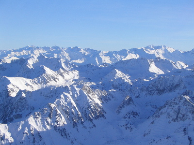
Pyrenees is a range/mtn in Europe, covering an estimated 20,678 km². It extends across France, Spain and Andorra.
The Pyrenees is a mountain range in southwestern Europe, straddling the France–Spain border. The Pyrenees extend nearly 500 kilometres (310 mi) from their union with the Cantabrian Mountains to Cap de Creus on the Mediterranean coast, reaching a maximum elevation of 3,404 metres (11,168 ft) at the peak of Aneto, in Huesca, Spain.
The main crest mostly forms a political divide between the states of Spain and France, with the microstate of Andorra sandwiched in between. Historically, the Crown of Aragon and the Kingdom of Navarre extended on both sides of the mountain range.
Adapted from Wikipedia: Pyrenees (CC BY-SA 4.0).
- Feature class
- Range/mtn
- Mapped extent
- 20,678 km²
- Size rank
- #124 of 216 mountain ranges
- Region
- Europe
- Countries
- France, Spain, Andorra
- Coordinates
- 42.5744°, 2.5416°
- Summits:
- Pic de Coma Pedrosa (2,943 m)
- Settlements:
- Andorra (10 km)
More about Pyrenees
Geography
The Spanish Pyrenees are part of the following provinces, from east to west: Girona, Barcelona and Lleida (all in Catalonia), Huesca and Zaragoza (both in Aragon), Navarra (in Navarre) and Gipuzkoa (in the Basque Country).
The French Pyrenees are part of the following départements, from east to west: Pyrénées-Orientales (also known as Northern Catalonia), Aude, Ariège, Haute-Garonne, Hautes-Pyrénées, and Pyrénées-Atlantiques (the latter two of which include the Pyrenees National Park).
The independent principality of Andorra is sandwiched in the eastern portion of the mountain range between the Spanish Pyrenees and French Pyrenees.
Physiographically, the Pyrenees may be divided into three sections: the Atlantic (or Western), the Central, and the Eastern Pyrenees.
Geology
The Pyrenees are older than the Alps: their sediments were first deposited in coastal basins during the Paleozoic and Mesozoic eras. During Ediacaran to Ordovician times, Pyrenees were located at the Northwest margin of Gondwana, where they formed a lateral continuity of neighbouring areas, such as the Montagne Noire and the Mouthoumet massifs and Southwestern territory of Sardinia. Between 100 and 150 million years ago, during the Early Cretaceous Period, the Bay of Biscay fanned out, pushing present-day Spain against France and applying intense compressional pressure to large layers of sedimentary rock. The intense pressure and uplifting of the Earth's crust first affected the eastern part and moved progressively to the entire chain, culminating in the Eocene Epoch.
Climate
The amount of precipitation the range receives, including rain and snow, is much greater in the western than in the eastern Pyrenees because of the moist air that blows in from the Atlantic Ocean over the Bay of Biscay. After dropping its moisture over the western and central Pyrenees, the air is left dry over the eastern Pyrenees. The winter average temperature is −2 °C (28 °F).
Sections of the mountain range vary in more than one respect. There are some glaciers in the western and snowy central Pyrenees, but there are no glaciers in the eastern Pyrenees because there is insufficient snowfall to cause their development.
Sections adapted from Wikipedia: Pyrenees (CC BY-SA 4.0).
Pyrenees: Key Facts
| Length | 491 km |
|---|---|
| Area | 19,000 km² |
| Highest point | Aneto |
Facts from Wikidata Q12431 (CC0).
Countries Bordering Andorra
Land and maritime neighbours.
More Maps in Europe
Andorra: Quick Answers
- What is the capital of Andorra?
- The capital of Andorra is Andorra la Vella.
- What is the population of Andorra?
- Andorra has a population of about 82,904, the #202 largest of 225 countries in YearMaps. Source: World Bank, 2025.
- How big is Andorra?
- Andorra covers 468 km², ranking #198 by area, with about 177 people per square kilometre.
- Which continent is Andorra in?
- Andorra is in Europe.
- Which countries border Andorra?
- Andorra shares a land or maritime border with Spain, France.
- What is the largest city in Andorra?
- Andorra is the largest city in Andorra, with a metropolitan population of about 53,998.
- What is the highest mountain in Andorra?
- The highest summit recorded for Andorra in YearMaps is Pic de Coma Pedrosa at 2,943 m (9,656 ft). Summits on a border are counted for both countries.