
UNESCO World Heritage Sites in Switzerland
Switzerland has 12 sites on the UNESCO World Heritage List (8 cultural and 4 natural), the first inscribed in 1983 (Abbey of Saint Gall). The map below plots every one of them alongside the rest of the List, and each site is written up in full further down the page.
- World Heritage Sites
- 12
- Cultural
- 8
- Natural and Mixed
- 4
- First Inscribed
- 1983
Map of World Heritage Sites in Switzerland
CulturalNaturalMixedIn DangerLarge dots are in Switzerland. Click a dot to read about the site.

Abbey of Saint Gall
Switzerland · 47.4231° N, 9.3772° E · 1 km from Saint Gallen
The Abbey of Saint Gall (German: Abtei St. Gallen) is a dissolved abbey (747–1805) in a Catholic religious complex in the city of St. Gallen in Switzerland. The Carolingian-era monastery existed from 719, founded by Saint Othmar on the spot where Saint Gall had erected his hermitage. It became an independent principality between 9th and 13th centuries, and was for many centuries one of the chief Benedictine abbeys in Europe. The library of the Abbey is one of the oldest monastic libraries in the world.
The city of St. Gallen originated as an adjoining settlement of the abbey. The abbey was secularized around 1800, and in 1848 its former church became St. Gallen Cathedral, the seat of the Diocese of Saint Gallen. Since 1983 the abbey precinct has been a UNESCO World Heritage Site.
Adapted from Wikipedia: Abbey of Saint Gall (CC BY-SA 4.0).
Why Abbey of Saint Gall Is Listed
- (ii)
- An important interchange of human values.
- (iv)
- An outstanding example of a type of building or landscape.
More about Abbey of Saint Gall
UNESCO's Description
The Convent of St Gall, a perfect example of a great Carolingian monastery, was, from the 8th century to its secularization in 1805, one of the most important in Europe. Its library is one of the richest and oldest in the world and contains precious manuscripts such as the earliest-known architectural plan drawn on parchment. From 1755 to 1768, the conventual area was rebuilt in Baroque style. The cathedral and the library are the main features of this remarkable architectural complex, reflecting 12 centuries of continuous activity.
From the UNESCO World Heritage Centre (CC BY-SA IGO 3.0).
History
Around 612 Gallus, according to tradition, an Irish monk and disciple and companion of Saint Columbanus, established a hermitage on the site that would become the monastery. He lived in his cell until his death in 646, and was buried there in Arbon (Canton of Thurgau). Afterwards, the people venerated him as a saint and prayed at his tomb for his intercession in times of danger.
Following Gallus' death, his disciples remained living together in his cell and followed the rule of St. Columban, which combined prayer, work of the hands, reading, and teaching. They aided and taught virtue to the many pilgrims who came to St. Gall's tomb. St. Magnus was the first successor of St. Gallen, but he soon left on a mission to Allgäu, Swabia.
Sections adapted from Wikipedia: Abbey of Saint Gall (CC BY-SA 4.0).
Key Facts
| Established | 720 CE |
|---|---|
| Architectural style | baroque architecture |
Facts from Wikidata Q155699 (CC0).
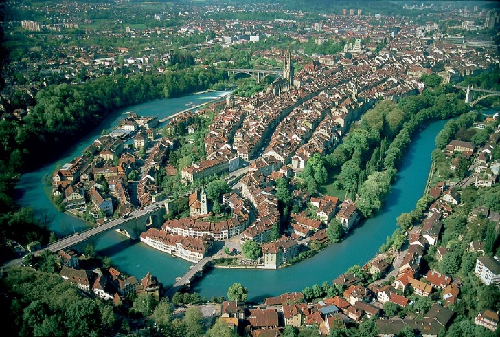
Old City of Bern
Switzerland · 46.9481° N, 7.4503° E · 1 km² · 4 km from Bern
The Old City (German: Altstadt) is the medieval city center of Bern, Switzerland. Built on a narrow hill bordered on three sides by the river Aare, its compact layout has remained essentially unchanged since its construction during the twelfth to the fifteenth century. Despite a major fire in 1405, after which much of the city was rebuilt in sandstone, and substantial construction efforts in the eighteenth century, Bern's old city has retained its medieval character.
The Old City is home to Switzerland's tallest minster as well as other churches, bridges and a large collection of Renaissance fountains. In addition to many historical buildings, the seats of the federal, cantonal and municipal government are also situated in the Old City. It is a UNESCO Cultural World Heritage Site since 1983 due to the compact and generally intact medieval core and is an excellent example of incorporating the modern world into a medieval city. Numerous buildings in the Old City have been designated as Swiss Cultural Properties of National Significance, as well as the entire Old City.
Adapted from Wikipedia: Old City (Bern) (CC BY-SA 4.0).
Why Old City of Bern Is Listed
- (iii)
- A unique testimony to a cultural tradition or civilisation.
More about Old City of Bern
UNESCO's Description
Founded in the 12th century on a hill site surrounded by the Aare River, Berne developed over the centuries in line with a an exceptionally coherent planning concept. The buildings in the Old City, dating from a variety of periods, include 15th-century arcades and 16th-century fountains. Most of the medieval town was restored in the 18th century but it has retained its original character.
From the UNESCO World Heritage Centre (CC BY-SA IGO 3.0).
History
The earliest settlements in the valley of the Aare date back to the Neolithic period. During the second century BC, the valley was settled by the Helvetii. Following the Roman conquest of Helvetia, a small Roman settlement was established near the Old City. This settlement was abandoned during the second century AD. From that time until the founding of Bern the area remained sparsely settled.
The history of the city of Bern proper begins with its founding by Duke Berchtold V of Zähringen in 1191. Local legend has it that the duke vowed to name the city after the first animal he met on the hunt, which turned out to be a bear. Both the name of the city (Bern can stand for Bär(e) n, bears) and its heraldic beast, come from this legend.
Sections adapted from Wikipedia: Old City (Bern) (CC BY-SA 4.0).

Saint John Abbey
Switzerland · 46.6292° N, 10.4478° E · 71 km from Bolzano
The Abbey of Saint John (German: Benediktinerinnenkloster St. Johann; Romansh: Claustra benedictina da Son Jon) is an early medieval Benedictine monastery in the Swiss municipality of Val Müstair, in the Canton of Graubünden. By reason of its exceptionally well-preserved heritage of Carolingian art, it has been a UNESCO World Heritage Site since 1983.
Adapted from Wikipedia: Saint John Abbey, Müstair (CC BY-SA 4.0).
Why Saint John Abbey Is Listed
- (iii)
- A unique testimony to a cultural tradition or civilisation.
More about Saint John Abbey
UNESCO's Description
The Convent of Müstair, which stands in a valley in the Grisons, is a good example of Christian monastic renovation during the Carolingian period. It has Switzerland's greatest series of figurative murals, painted c. A.D. 800, along with Romanesque frescoes and stuccoes.
From the UNESCO World Heritage Centre (CC BY-SA IGO 3.0).
History
The Carolingian Renaissance is deeply in debt to the success of Charlemagne as a king and patron, and the driving force behind what we see in St John Abbey. Throughout history, art, education and leisure have all only truly thrived in times of peace, although war is often the most important factor for technological change. In the early Middle Ages the constant conflicts between the Frankish Kingdoms hindered the artistic progress previously enjoyed by the Romans when their empire was at its height. Under Charlemagne's prosperous kingship, the introduction of a new peacetime monastic order began, paving the way for the frescos and architecture seen at Saint John Abbey.
Sections adapted from Wikipedia: Saint John Abbey, Müstair (CC BY-SA 4.0).
Key Facts
| Established | 8th century |
|---|---|
| Area | 20.4 km² |
Facts from Wikidata Q757067 (CC0).

Three Castles of Bellinzona
Switzerland · 46.1928° N, 9.0222° E · 22 km from Lugano
The Castles of Bellinzona are a group of fortifications located around the town of Bellinzona, the capital of the Swiss canton of Ticino. Situated on the Alpine foothills, the group is composed of fortified walls and three castles named Castelgrande, Montebello and Sasso Corbaro. Castelgrande is located on a rocky peak overlooking the valley, with a series of walls that protect the old city and connect to Montebello. Sasso Corbaro, the highest of the three castles, is located on an isolated rocky promontory south-east of the other two. The Castles of Bellinzona with their defensive walls have been an UNESCO World Heritage Site since 2000.
Adapted from Wikipedia: Castles of Bellinzona (CC BY-SA 4.0).
Why Three Castles of Bellinzona Is Listed
- (iv)
- An outstanding example of a type of building or landscape.
More about Three Castles of Bellinzona
UNESCO's Description
The Bellinzona site consists of a group of fortifications grouped around the castle of Castelgrande, which stands on a rocky peak looking out over the entire Ticino valley. Running from the castle, a series of fortified walls protect the ancient town and block the passage through the valley. A second castle (Montebello) forms an integral part of the fortifications, while a third but separate castle (Sasso Corbaro) was built on an isolated rocky promontory south-east of the other fortifications.
From the UNESCO World Heritage Centre (CC BY-SA IGO 3.0).
History
Bellinzona has always occupied an important geographic location in the Swiss Alps. It is situated a few kilometres south of Arbedo, where the Ticino and Moesa meet. Several key Alpine pass routes, connecting northern to southern Europe, including the Nufenen, St. Gotthard, Lukmanier and San Bernardino, all converge in the area around Bellinzona making it a key trading center.
While the region has been occupied since the early Neolithic age it was not until the late 1st century BC that a fort was built on the massive gneiss outcropping known as Castelgrande during the reign of the Roman Emperor Augustus. While the fort fell into disrepair in the following centuries, it was rebuilt and greatly expanded in the 4th century AD.
Sections adapted from Wikipedia: Castles of Bellinzona (CC BY-SA 4.0).
Key Facts
| Area | 0.1 km² |
|---|---|
| Architectural style | medieval architecture |
Facts from Wikidata Q510279 (CC0).

Jungfrau-Aletsch protected area
Switzerland · 46.5000° N, 8.0333° E · 824 km² · 60 km from Sion
The Jungfrau-Aletsch protected area (officially Swiss Alps Jungfrau-Aletsch) is located in south-western Switzerland between the cantons of Bern and Valais. It is a mountainous region in the easternmost side of the Bernese Alps, containing the northern wall of Jungfrau and Eiger, and the largest glaciated area in western Eurasia, comprising the Aletsch Glacier. The Jungfrau-Aletsch protected area is the first World Natural Heritage site in the Alps; it was inscribed in 2001.
Adapted from Wikipedia: Jungfrau-Aletsch protected area (CC BY-SA 4.0).
Why Jungfrau-Aletsch protected area Is Listed
- (vii)
- Superlative natural phenomena or exceptional natural beauty.
- (viii)
- An outstanding example of major stages of the Earth's history.
- (ix)
- An outstanding example of ongoing ecological and biological processes.
More about Jungfrau-Aletsch protected area
UNESCO's Description
The extension of the natural World Heritage property of Jungfrau - Aletsch - Bietschhorn (first inscribed in 2001), expands the site to the east and west, bringing its surface area up to 82,400 ha., up from 53,900. The site provides an outstanding example of the formation of the High Alps, including the most glaciated part of the mountain range and the largest glacier in Eurasia. It features a wide diversity of ecosystems, including successional stages due particularly to the retreat of glaciers resulting from climate change. The site is of outstanding universal value both for its beauty and for the wealth of information it contains about the formation of mountains and glaciers, as well as ongoing climate change. It is also invaluable in terms of the ecological and biological processes it illustrates, notably through plan succession. Its impressive landscape has played an important role in European art, literature, mountaineering and alpine tourism.
From the UNESCO World Heritage Centre (CC BY-SA IGO 3.0).
Geography and climate
The Jungfrau-Aletsch protected area is located in the Swiss Alps between the Bernese Oberland and north-eastern Valais, about 25 km south of Interlaken and 20 km north of Brig. The site covers the whole Aar massif from the Oeschinensee in the west to the Grimselsee (not comprised) in the east, including the basins of the Aletsch, Fiescher, Aar and Grindelwald glaciers.
The culminating point is the Finsteraarhorn which, with its 4,270 metres, is also the highest mountain in the Bernese Alps. 8 other summits above 4,000 metres are located in the area: Aletschhorn, Jungfrau, Mönch, Schreckhorn, Gross Fiescherhorn, Hinter Fiescherhorn, Grünhorn and Lauteraarhorn.
The summit ridge separating the cantons of Valais and Bern is the main watershed of Europe.
Tourism
The regions of the Bernese Oberland and Valais have been popular tourist destinations since the 19th century. The Jungfrau was first climbed in 1811 and the Finsteraarhorn in 1812. The first tourists came mostly in summer, but in the 1930s winter sports became also popular. On the north side visitors are only able to visit the site via the Jungfrau railway which leads to the Jungfraujoch. The railway has turned the site from an inaccessible mountain face to a very accessible site visited by large nearby populations. The Jungfrau railway was built between 1870 and 1912, taking visitors from Kleine Scheidegg (2,061 m) to Jungfraujoch (3,454 m), the saddle between the Mönch and Jungfrau. On the south side the area of Riederalp-Bettmeralp hosts most of the visitors.
Sections adapted from Wikipedia: Jungfrau-Aletsch protected area (CC BY-SA 4.0).
Key Facts
| Established | 2001 |
|---|---|
| Area | 824 km² |
Facts from Wikidata Q616912 (CC0).

Monte San Giorgio
Switzerland · 45.9167° N, 8.9500° E · 11 km² · 9 km from Lugano
Monte San Giorgio is a Swiss mountain and UNESCO World Heritage Site near the border between Switzerland and Italy. It is part of the Lugano Prealps, overlooking Lake Lugano in the Swiss Canton of Ticino.
Monte San Giorgio is a wooded mountain, rising to 1,097 m (3,600 feet) above sea level. It has a roughly pyramidal shape, with a steep north edge sloping towards Lake Lugano and a more shallow South Slope extending towards the Po Plain. The eastern (Swiss) side of the mountain, between the municipalities of Brusino Arsizio, Riva San Vitale, and Meride, was listed as a World Heritage Site in 2003. This was in recognition of its cultural, biological, and especially paleontological significance. The site is renowned for its fossil content, one of the best known records of marine life in the Middle Triassic period. The Italian region west of Poncione d'Arzo (Porto Ceresio) was added as an extension to the World Heritage Site in 2010.
Adapted from Wikipedia: Monte San Giorgio (CC BY-SA 4.0).
Why Monte San Giorgio Is Listed
- (viii)
- An outstanding example of major stages of the Earth's history.
More about Monte San Giorgio
UNESCO's Description
The pyramid-shaped, wooded mountain of Monte San Giorgio beside Lake Lugano is regarded as the best fossil record of marine life from the Triassic Period (245–230 million years ago). The sequence records life in a tropical lagoon environment, sheltered and partially separated from the open sea by an offshore reef. Diverse marine life flourished within this lagoon, including reptiles, fish, bivalves, ammonites, echinoderms and crustaceans. Because the lagoon was near land, the remains also include land-based fossils of reptiles, insects and plants, resulting in an extremely rich source of fossils.
From the UNESCO World Heritage Centre (CC BY-SA IGO 3.0).
Geology
The geological layers of Monte San Giorgio span more than 100 million years, from the Permian to Jurassic periods. The rocks forming the mountain dip southwards, with older rocks exposed as one travels north and younger rocks exposed as one travels south. The oldest rocks are Permian volcanic basement material on the mountain's steep north slope. These are followed by Triassic sediments and carbonates at higher elevations on the mountain. Middle Triassic layers are the most fossiliferous and extraordinary from a global perspective, and are encompassed by the protected area north of Meride. South of Meride, they are replaced by Late Triassic coastal sediments which give way to Early Jurassic limestone overlooking the Po Plain.
History and cultural heritage
Humans have inhabited Monte San Giorgio at least since the area's equivalent of the Neolithic Period, around 6,000 years ago. The south side of the mountain is home to Tremona-Castello Archaeological Park, a fortress and settlement which was continuously inhabited by artisans from the Neolithic up until the 14th century. Artifacts, architecture, and other evidence of Roman and medieval activity are abundant on and around the mountain. Productive limestone quarries were active during this period and beyond in Italy (Viggiù and Saltrio) and Switzerland (Arzo).
The mountain's fossil fuel deposits were exploited more recently.
Sections adapted from Wikipedia: Monte San Giorgio (CC BY-SA 4.0).

Lavaux
Switzerland · 46.4919° N, 6.7461° E · 9 km² · 9 km from Lausanne
Lavaux (French pronunciation: [lavo]) is a region in the canton of Vaud in Switzerland, in the district of Lavaux-Oron. Lavaux consists of 830 hectares (2,100 acres) of terraced vineyards that stretch for about 30 kilometres (19 mi) along the south-facing northern shores of Lake Geneva. The region is designated a UNESCO World Heritage Site with the formal name Lavaux, Vineyard Terraces.
The terraced vineyards in the area date back to the 11th century, under the rule of Benedictine and Cistercian monasteries. The main wine grape variety grown here is the Chasselas.
Adapted from Wikipedia: Lavaux (CC BY-SA 4.0).
Why Lavaux Is Listed
- (iii)
- A unique testimony to a cultural tradition or civilisation.
- (iv)
- An outstanding example of a type of building or landscape.
- (v)
- An outstanding example of traditional human settlement or land use.
More about Lavaux
UNESCO's Description
The Lavaux Vineyard Terraces, stretching for about 30 km along the south-facing northern shores of Lake Geneva from the Chateau de Chillon to the eastern outskirts of Lausanne in the Vaud region, cover the lower slopes of the mountainside between the villages and the lake. Although there is some evidence that vines were grown in the area in Roman times, the present vine terraces can be traced back to the 11th century, when Benedictine and Cistercian monasteries controlled the area. It is an outstanding example of a centuries-long interaction between people and their environment, developed to optimize local resources so as to produce a highly valued wine that has always been important to the economy.
From the UNESCO World Heritage Centre (CC BY-SA IGO 3.0).
Description
Lavaux is a region of terraced vineyards in the Canton of Vaud, Switzerland, stretching for around 30 km (19 mi) along the northern shore of Lake Geneva. Since July 2007, it has been designated a UNESCO World Heritage Site with the formal name Lavaux, Vineyard Terraces.
Since 2016, the vineyards of Lavaux are no longer treated with synthetic pesticides.
Sections adapted from Wikipedia: Lavaux (CC BY-SA 4.0).
Visiting Lavaux
Lavaux is internationally famous as a terraced wine-growing region on the shores of Lake Geneva (Lac Léman) in western Switzerland. It covers the territory roughly from Lausanne to Montreux, extending to an altitude of roughly 500 meters above lake level and including 6 lake shore villages and the city of Vevey.
Travel notes adapted from Wikivoyage: Lavaux (CC BY-SA 4.0).

Glarus thrust
Switzerland · 46.9167° N, 9.2500° E · 329 km² · 20 km from Chur
The Glarus thrust (German: Glarner Überschiebung) is a major thrust fault in the Alps of eastern Switzerland. Along the thrust the Helvetic nappes were thrust more than 100 km to the north over the external Aarmassif and Infrahelvetic complex. The thrust forms the contact between older (Helvetic) Permo-Triassic rock layers of the Verrucano group and younger (external) Jurassic and Cretaceous limestones and Paleogene flysch and molasse.
The Glarus thrust crops out over a relatively large area in the cantons Glarus, St. Gallen and Graubünden, due to its horizontal orientation and the high local relief. Famous outcrops include those at Lochsite near Glarus (the town) and in a mountain cliff called Tschingelhörner between Elm and Flims (in the same cliff is a natural hole called the Martinsloch).
Adapted from Wikipedia: Glarus thrust (CC BY-SA 4.0).
Why Glarus thrust Is Listed
- (viii)
- An outstanding example of major stages of the Earth's history.
More about Glarus thrust
UNESCO's Description
The Swiss Tectonic Arena Sardona in the north-eastern part of the country covers a mountainous area of 32,850 ha which features seven peaks that rise above 3,000 m. The area displays an exceptional example of mountain building through continental collision and features . excellent geological sections through tectonic thrust, i.e. the process whereby older, deeper rocks are carried onto younger, shallower rocks. The site is distinguished by the clear three-dimensional exposure of the structures and processes that characterize this phenomenon and has been a key site for the geological sciences since the 18 th century. The Glarus Alps are glaciated mountains rising dramatically above narrow river valleys and are the site of the largest post-glacial landslide in the Central Alpine region.
From the UNESCO World Heritage Centre (CC BY-SA IGO 3.0).
History
The first naturalist to examine the Glarus thrust was Hans Conrad Escher von der Linth (1767–1823). Escher von der Linth discovered that, contradictory to Steno's law of superposition, older rocks are on top of younger ones in certain outcrops in Glarus. His son Arnold Escher von der Linth (1807–1872), the first professor in geology at the ETH at Zürich, mapped the structure in more detail and concluded that it could be a huge thrust. At the time, most geologists still accepted the theory of geosynclines, which states that mountains are formed by vertical movements within the Earth's crust. Escher von der Linth had therefore difficulty with explaining the size of the thrust fault.
Sections adapted from Wikipedia: Glarus thrust (CC BY-SA 4.0).

Rhaetian Railway in the Albula / Bernina Landscapes
Switzerland, Italy · 46.4089° N, 10.0197° E · 2 km² · 63 km from Chur
Rhaetian Railway in the Albula / Bernina Landscapes is a World Heritage Site comprising the Albula Railway and the Bernina Railway. The best known trains operating on this site are the Glacier Express and the Bernina Express.
Adapted from Wikipedia: Rhaetian Railway in the Albula / Bernina Landscapes (CC BY-SA 4.0).
Why Rhaetian Railway in the Albula / Bernina Landscapes Is Listed
- (ii)
- An important interchange of human values.
- (iv)
- An outstanding example of a type of building or landscape.
More about Rhaetian Railway in the Albula / Bernina Landscapes
UNESCO's Description
Rhaetian Railway in the Albula / Bernina Landscapes, brings together two historic railway lines that cross the Swiss Alps through two passes. Opened in 1904, the Albula line in the north western part of the property is 67 km long. It features an impressive set of structures including 42 tunnels and covered galleries and 144 viaducts and bridges. The 61 km Bernina pass line features 13 tunnels and galleries and 52 viaducts and bridges. The property is exemplary of the use of the railway to overcome the isolation of settlements in the Central Alps early in the 20th century, with a major and lasting socio-economic impact on life in the mountains. It constitutes an outstanding technical, architectural and environmental ensemble and embodies architectural and civil engineering achievements, in harmony with the landscapes through which they pass.
From the UNESCO World Heritage Centre (CC BY-SA IGO 3.0).
Key Facts
| Area | 1.5 km² |
|---|
Facts from Wikidata Q2962401 (CC0).

La Chaux-de-Fonds / Le Locle, Watchmaking Town Planning
Switzerland · 47.0800° N, 6.7800° E · 3 km² · 14 km from Neuchâtel
The site of La Chaux-de-Fonds / Le Locle watchmaking town-planning consists of two towns situated close to one another in a remote environment in the Swiss Jura mountains, on land ill-suited to farming. Their planning and buildings reflect watchmakers’ need of rational organization. Planned in the early 19th century, after extensive fires, the towns owed their existence to this single industry. Their layout along an open-ended scheme of parallel strips on which residential housing and workshops are intermingled reflects the needs of the local watchmaking culture that dates to the 17th century and is still alive today. The site presents outstanding examples of mono-industrial manufacturing-towns which are well preserved and still active. The urban planning of both towns has accommodated the transition from the artisanal production of a cottage industry to the more concentrated factory production of the late 19th and 20th centuries. The town of La Chaux-de-Fonds was described by Karl Marx as a “huge factory-town” in Das Kapital where he analyzed the division of labour in the watchmaking industry of the Jura.
Description from the UNESCO World Heritage Centre (CC BY-SA IGO 3.0).
Why La Chaux-de-Fonds / Le Locle, Watchmaking Town Planning Is Listed
- (iv)
- An outstanding example of a type of building or landscape.
Shared With Neighbouring Countries
These sites cross the border. Each is written up on the page of the country UNESCO lists first.
 Ancient and Primeval Beech Forests of the Carpathians and Other Regions of EuropeNatural · 2007 · Albania, Austria, Bosnia and Herzegovina, Bulgaria, Switzerland, Czechia, Germany, Spain, France, Croatia, Italy, North Macedonia, Poland, Slovenia, Slovakia, UkraineRead on the Albania page →
 prehistoric pile dwellings around the AlpsCultural · 2011 · Austria, Switzerland, Germany, France, Italy, SloveniaRead on the Austria page →
World Heritage in Switzerland: Quick Answers
- How many UNESCO World Heritage Sites are in Switzerland?
- Switzerland has 12 World Heritage Sites: 8 cultural and 4 natural. 2 of them are shared with a neighbouring country.
- What was the first World Heritage Site in Switzerland?
- Abbey of Saint Gall, inscribed in 1983. The most recent is prehistoric pile dwellings around the Alps, inscribed in 2011.
- What are the natural World Heritage Sites in Switzerland?
- Jungfrau-Aletsch protected area, Monte San Giorgio, Ancient and Primeval Beech Forests of the Carpathians and Other Regions of Europe, Glarus thrust.
- Are any World Heritage Sites in Switzerland in danger?
- None of the World Heritage Sites in Switzerland is on UNESCO's List of World Heritage in Danger.