
UNESCO World Heritage Sites in United Kingdom
United Kingdom has 33 sites on the UNESCO World Heritage List (27 cultural, 5 natural and 1 mixed), the first inscribed in 1986 (Castles and Town Walls of King Edward in Gwynedd). The map below plots every one of them alongside the rest of the List, and each site is written up in full further down the page.
- World Heritage Sites
- 33
- Cultural
- 27
- Natural and Mixed
- 6
- First Inscribed
- 1986
Map of World Heritage Sites in United Kingdom
CulturalNaturalMixedIn DangerLarge dots are in United Kingdom. Click a dot to read about the site.

Castles and Town Walls of King Edward in Gwynedd
United Kingdom · 53.1397° N, 4.2769° W · 91 km from Chester
The Castles and Town Walls of King Edward in Gwynedd is a UNESCO-designated World Heritage Site located in North West Wales (specifically Gwynedd until 1996). It includes the castles of Beaumaris and Harlech and the castles and town walls of Caernarfon and Conwy. UNESCO considers the sites to be the "finest examples of late 13th century and early 14th century military architecture in Europe".
The fortifications form part of the Ring of Iron built by Edward I after his invasion of North Wales in 1282. Edward defeated the local Welsh princes in a major campaign and set about permanently colonising the area. He created new fortified towns, protected by castles, in which English immigrants could settle and administer the territories. The project was hugely expensive and stretched royal resources to the limit. Fresh Welsh revolts followed in 1294 under the leadership of Madog ap Llywelyn. Conwy and Harlech were kept supplied by sea and held out against the attack, but Caernarfon, still only partially completed, was stormed. In the aftermath, Edward reinvigorated the building programme and ordered the commencement of work at Beaumaris.
Adapted from Wikipedia: Castles and Town Walls of King Edward in Gwynedd (CC BY-SA 4.0).
Why Castles and Town Walls of King Edward in Gwynedd Is Listed
- (i)
- A masterpiece of human creative genius.
- (iii)
- A unique testimony to a cultural tradition or civilisation.
- (iv)
- An outstanding example of a type of building or landscape.
More about Castles and Town Walls of King Edward in Gwynedd
UNESCO's Description
The castles of Beaumaris and Harlech (largely the work of the greatest military engineer of the time, James of St George) and the fortified complexes of Caernarfon and Conwy are located in the former principality of Gwynedd, in north Wales. These extremely well-preserved monuments are examples of the colonization and defence works carried out throughout the reign of Edward I (1272–1307) and the military architecture of the time.
From the UNESCO World Heritage Centre (CC BY-SA IGO 3.0).
History
The Edwardian castles and town walls in Gwynedd were built as a consequence of the wars fought for the control of Wales in the late 13th century. The kings of England and the Welsh princes had vied for control of the region since the 1070s, with Norman and English nobles and settlers slowly expanding their territories over several centuries. In the 1260s, however, the Welsh leader Llywelyn ap Gruffudd exploited a civil war between Henry III and rebel barons in England to become the dominant power, and was formally recognised as the prince of Wales under the Treaty of Montgomery.
Edward I became the king of England in 1272.
Sections adapted from Wikipedia: Castles and Town Walls of King Edward in Gwynedd (CC BY-SA 4.0).
Key Facts
| Established | 1280s |
|---|---|
| Area | 0.1 km² |
Facts from Wikidata Q837627 (CC0).

Durham Castle and Cathedral
United Kingdom · 54.7747° N, 1.5761° W · 20 km from Sunderland
Durham Cathedral was built in the late 11th and early 12th centuries to house the relics of St Cuthbert (evangelizer of Northumbria) and the Venerable Bede. It attests to the importance of the early Benedictine monastic community and is the largest and finest example of Norman architecture in England. The innovative audacity of its vaulting foreshadowed Gothic architecture. Behind the cathedral stands the castle, an ancient Norman fortress which was the residence of the prince-bishops of Durham.
Description from the UNESCO World Heritage Centre (CC BY-SA IGO 3.0).
Why Durham Castle and Cathedral Is Listed
- (ii)
- An important interchange of human values.
- (iv)
- An outstanding example of a type of building or landscape.
- (vi)
- A direct association with events, ideas or beliefs of universal significance.

Fountains Abbey
United Kingdom · 54.1097° N, 1.5814° W · 3 km² · 31 km from Leeds
Fountains Abbey is a ruined Cistercian monastery near Ripon in North Yorkshire, England. It was founded in 1132 under the direction of Thurstan, archbishop of York, and over the next four centuries became one of the wealthiest monasteries in England thanks to its large and diverse landholdings. The monastery was dissolved in 1539 as part of the English Reformation and its estates sold. Fountains Abbey is now within Studley Royal Park, a landscaped garden created in the eighteenth century.
Even in its current state, Fountains is described by Historic England as "the best preserved of English abbeys and [...] the finest picturesque ruin." The majority of the buildings were constructed in the Romanesque and Early English Gothic style between 1170 and 1247, with significant additions in the late fifteenth and early sixteenth centuries. The abbey church and many of the claustral buildings survive, including the chapter house, refectory, and lay brothers' dormitory, as well as ancillary structures such as the guest houses, abbey mill, and bridges.
Adapted from Wikipedia: Fountains Abbey (CC BY-SA 4.0).
Why Fountains Abbey Is Listed
- (i)
- A masterpiece of human creative genius.
- (iv)
- An outstanding example of a type of building or landscape.
More about Fountains Abbey
UNESCO's Description
In the 18th century a designed landscape of exceptional beauty was created around the ruins of the Cistercian Fountains Abbey, in Yorkshire. The spectacular ruins of the 12th century abbey and water mill, the Jacobean mansion of Fountains Hall, the Victorian masterpiece St Mary’s Church and one of the most magnificent Georgian water gardens ever created, make this a landscape of outstanding merit.
From the UNESCO World Heritage Centre (CC BY-SA IGO 3.0).
Endowments and economy
Medieval monasteries were sustained by landed estates that were given to them as endowments and from which they derived an income from rents. They were the gifts of the founder and subsequent patrons, but some were purchased from cash revenues. At the outset, the Cistercian order rejected gifts of mills and rents, churches with tithes and feudal manors as they did not accord with their belief in monastic purity, because they involved contact with laymen. When Archbishop Thurstan founded the abbey he gave the community 260 acres (110 ha) of land at Sutton north of the abbey and 200 acres (81 ha) at Herleshowe to provide support while the abbey became established. In the early years the abbey struggled to maintain itself because further gifts were not forthcoming.
Sections adapted from Wikipedia: Fountains Abbey (CC BY-SA 4.0).

Giant's Causeway
United Kingdom · 55.2408° N, 6.5117° W · 2 km² · 59 km from Londonderry
The Giant's Causeway (Irish: Clochán an Aifir or Clochán na bhFomhórach) is an area of approximately 40,000 interlocking basalt columns, the result of an ancient volcanic fissure eruption, part of the North Atlantic Igneous Province active in the region during the Paleogene period. It is located in County Antrim on the north coast of Northern Ireland, about three miles (five kilometres) northeast of Bushmills.
It was declared a World Heritage Site by UNESCO in 1986 and a national nature reserve by the Department of the Environment for Northern Ireland in 1987. In a 2005 poll of Radio Times readers, the Giant's Causeway was named the fourth-greatest natural wonder in the United Kingdom.
The tops of the columns form stepping stones that lead from the cliff foot and disappear under the sea. Most of the columns are hexagonal, although some have between four and eight sides. The tallest are approximately 12 metres (39 ft) high, and the solidified lava in the cliffs is 28 metres (92 ft) thick in places.
Much of the Giant's Causeway and Causeway Coast World Heritage Site is owned and managed by the National Trust.
Adapted from Wikipedia: Giant's Causeway (CC BY-SA 4.0).
Why Giant's Causeway Is Listed
- (vii)
- Superlative natural phenomena or exceptional natural beauty.
- (viii)
- An outstanding example of major stages of the Earth's history.
More about Giant's Causeway
UNESCO's Description
The Giant's Causeway lies at the foot of the basalt cliffs along the sea coast on the edge of the Antrim plateau in Northern Ireland. It is made up of some 40,000 massive black basalt columns sticking out of the sea. The dramatic sight has inspired legends of giants striding over the sea to Scotland. Geological studies of these formations over the last 300 years have greatly contributed to the development of the earth sciences, and show that this striking landscape was caused by volcanic activity during the Tertiary, some 50–60 million years ago.
From the UNESCO World Heritage Centre (CC BY-SA IGO 3.0).
Geology
Around 50 to 60 million years ago, during the Paleocene Epoch, Antrim was subject to intense volcanic activity, when highly fluid molten basalt intruded through chalk beds to form an extensive volcanic plateau. As the lava cooled, contraction occurred. Horizontal contraction fractured in a similar way to drying mud, with the cracks propagating down as the mass cooled, leaving pillarlike structures that also fractured horizontally into "biscuits". In many cases, the horizontal fracture resulted in a bottom face that is convex, while the upper face of the lower segment is concave, producing what are called "ball and socket" joints. The size of the columns was primarily determined by the speed at which lava cooled. The extensive fracture network produced the distinctive columns seen today.
Tourism
William King, Bishop of Derry visited the site in 1692. The existence of the causeway was announced to the wider world the following year by the presentation of a paper to the Royal Society from Sir Richard Bulkeley, a fellow of Trinity College, Dublin. The Giant's Causeway received international attention when Dublin artist Susanna Drury made watercolour paintings of it in 1739; they won Drury the first award presented by the Royal Dublin Society in 1740 and were engraved in 1743. In 1765, an entry on the causeway appeared in volume 12 of the French Encyclopédie, which was informed by the engravings of Drury's work; the engraving of the "East Prospect" appeared in a 1768 volume of plates published for the Encyclopédie.
Sections adapted from Wikipedia: Giant's Causeway (CC BY-SA 4.0).
Visiting Giant's Causeway
Giant's Causeway is a spectacular series of rock formations on the coast of County Antrim in Northern Ireland. The site stretches for 2-3 miles, with some 40,000 basalt columns rising out of the sea. It's owned by the National Trust and is Northern Ireland's only UNESCO World Heritage Site: it's impressive but very touristy, with a million visitors each year. It's mobbed on fine weekends, try to visit off-peak.
Travel notes adapted from Wikivoyage: Giant's Causeway (CC BY-SA 4.0).

Ironbridge Gorge
United Kingdom · 52.6264° N, 2.4728° W · 5 km² · 41 km from Birmingham
The Ironbridge Gorge is a deep gorge, containing the River Severn in Shropshire, England. It was first formed by a glacial overflow from the long drained away Lake Lapworth, at the end of the last ice age. The deep exposure of the rocks cut through by the gorge exposed commercial deposits of coal, iron ore, limestone and fireclay, which enabled the rapid economic development of the area during the early Industrial Revolution.
Originally called the Severn Gorge, the gorge now takes its name from its famous Iron Bridge, the first iron bridge of its kind in the world, and a monument to the industry that began there. The bridge was built in 1779 to link the industrial town of Broseley with the smaller mining town of Madeley and the growing industrial centre of Coalbrookdale.
There are two reasons the site was so useful to the early industrialists. The raw materials, coal, iron ore, limestone and clay, for the manufacture of iron, tiles and porcelain are exposed or easily mined in the gorge. The deep and wide river allowed easy transport of products to the sea at the Bristol Channel.
Adapted from Wikipedia: Ironbridge Gorge (CC BY-SA 4.0).
Why Ironbridge Gorge Is Listed
- (i)
- A masterpiece of human creative genius.
- (ii)
- An important interchange of human values.
- (iv)
- An outstanding example of a type of building or landscape.
- (vi)
- A direct association with events, ideas or beliefs of universal significance.
More about Ironbridge Gorge
UNESCO's Description
Ironbridge is known throughout the world as the symbol of the Industrial Revolution. It contains all the elements of progress that contributed to the rapid development of this industrial region in the 18th century, from the mines themselves to the railway lines. Nearby, the blast furnace of Coalbrookdale, built in 1708, is a reminder of the discovery of coke. The bridge at Ironbridge, the world's first bridge constructed of iron, had a considerable influence on developments in the fields of technology and architecture.
From the UNESCO World Heritage Centre (CC BY-SA IGO 3.0).

St Kilda
United Kingdom · 57.8150° N, 8.5875° W · 258 km²
St Kilda (Scottish Gaelic: Hiort) is a remote archipelago situated 35 nautical miles (65 kilometres) west-northwest of North Uist in the North Atlantic Ocean. It contains the westernmost islands of the Outer Hebrides of Scotland. The largest island is Hirta, whose sea cliffs are the highest in the United Kingdom; three other islands (Dùn, Soay and Boreray) were also used for grazing and seabird hunting. The islands are administratively a part of the Comhairle nan Eilean Siar local authority area.
The origin of the name St Kilda is a matter of conjecture. The islands' human heritage includes unique architectural features from the historic and prehistoric periods, although the earliest written records of island life date from the Late Middle Ages. The medieval village on Hirta was rebuilt in the 19th century, but illnesses brought by increased external contacts through tourism, and the upheaval of the First World War, contributed to the island's evacuation. Permanent habitation on the islands possibly extends back two millennia, the population probably never exceeding 180; its peak was in the late 17th century.
Adapted from Wikipedia: St Kilda, Scotland (CC BY-SA 4.0).
Why St Kilda Is Listed
- (iii)
- A unique testimony to a cultural tradition or civilisation.
- (v)
- An outstanding example of traditional human settlement or land use.
- (vii)
- Superlative natural phenomena or exceptional natural beauty.
- (ix)
- An outstanding example of ongoing ecological and biological processes.
- (x)
- The most important natural habitats for conserving biodiversity.
More about St Kilda
UNESCO's Description
This volcanic archipelago, with its spectacular landscapes, is situated off the coast of the Hebrides and comprises the islands of Hirta, Dun, Soay and Boreray. It has some of the highest cliffs in Europe, which have large colonies of rare and endangered species of birds, especially puffins and gannets. The archipelago, uninhabited since 1930, bears the evidence of more than 2,000 years of human occupation in the extreme conditions prevalent in the Hebrides. Human vestiges include built structures and field systems, the cleits and the traditional Highland stone houses. They feature the vulnerable remains of a subsistence economy based on the products of birds, agriculture and sheep farming.
From the UNESCO World Heritage Centre (CC BY-SA IGO 3.0).
Geography
The islands are composed of Tertiary igneous formations of granites and gabbro, heavily weathered by the elements. The archipelago represents the remnants of a long-extinct ring volcano rising from a seabed plateau approximately 40 metres (130 ft) below sea level.
At 670 hectares (1,700 acres) in extent, Hirta is the largest island in the group and comprises more than 78% of the land area of the archipelago. Next in size are Soay (English: "sheep island") at 99 hectares (240 acres) and Boreray ("the fortified isle"), which measures 86 hectares (210 acres). Soay is 500 metres (1⁄4 nautical mile) northwest of Hirta, Boreray six kilometres (3 nmi) northeast.
History
It has been known for some time that St Kilda was continuously inhabited for two millennia or more, from the Bronze Age until 1930. In 2015, the first direct evidence of earlier Neolithic settlement emerged, sherds of pottery of the Hebridean ware style, found to the east of the village. The subsequent discovery of a quarry for stone tools on Mullach Sgar above Village Bay led to finds of numerous stone hoe-blades, grinders and Skaill knives in the Village Bay cleitean, unique stone storage buildings (see below). These tools are also probably of Neolithic origin.
The potsherds appear to have been made of local material, rather than material brought from other islands in the Hebrides, suggesting that the islands were settled in the 4th millennium BC. Iron Age pottery is also known.
21st-century tourism
Visits to St Kilda were encouraged until facilities closed due to the worldwide COVID-19 pandemic in 2020 but it has since reopened.
The National Trust for Scotland has improved the village on Hirta over the years. "They have reroofed the cottages on the main street, restored the church, and re-stacked stones that years of gales had toppled from the cleits, or bothies, that dot the volcanic landscape". One cottage, #3 on "The Street" has been more extensively restored and turned into the museum. However, a full restoration of the other cottages is not expected.
The Historic Environment Scotland website states that "the plain, two-bay church, with the schoolroom added to its north west in 1898" was "restored as they might have appeared in the 1920s."
Sections adapted from Wikipedia: St Kilda, Scotland (CC BY-SA 4.0).

Stonehenge
United Kingdom · 51.1789° N, 1.8261° W · 52 km² · 43 km from Southampton
Stonehenge is a prehistoric megalithic structure on Salisbury Plain in Wiltshire, England, two miles (3 km) west of Amesbury. It consists of an outer ring of vertical sarsen standing stones, each around 13 feet (4.0 m) high, seven feet (2.1 m) wide, and weighing around 25 tons, topped by connecting horizontal lintel stones which are held in place with mortise and tenon joints—a feature unique among contemporary monuments. Inside is a ring of smaller bluestones. Inside these are free-standing trilithons: two bulkier vertical sarsens joined by a single lintel. The whole monument, now in ruins, is aligned towards the sunrise on the summer solstice and sunset on the winter solstice. The stones are set within earthworks in the middle of the densest complex of Neolithic and Bronze Age monuments in England, including several hundred tumuli (burial mounds).
Stonehenge was constructed in several phases, beginning about 3100 BC and continuing until about 1600 BC. The famous circle of large sarsen stones was placed between 2600 BC and 2400 BC. The surrounding circular earth bank and ditch, which constitute the earliest phase of the monument, have been dated to about 3100 BC.
Adapted from Wikipedia: Stonehenge (CC BY-SA 4.0).
Why Stonehenge Is Listed
- (i)
- A masterpiece of human creative genius.
- (ii)
- An important interchange of human values.
- (iii)
- A unique testimony to a cultural tradition or civilisation.
More about Stonehenge
UNESCO's Description
Stonehenge and Avebury, in Wiltshire, are among the most famous groups of megaliths in the world. The two sanctuaries consist of circles of menhirs arranged in a pattern whose astronomical significance is still being explored. These holy places and the nearby Neolithic sites are an incomparable testimony to prehistoric times.
From the UNESCO World Heritage Centre (CC BY-SA IGO 3.0).
Early history
Stonehenge was a place of burial from its beginning to its zenith in the mid third [sic] millennium B.C. The cremation burial dating to Stonehenge's sarsen stones phase is probably just one of many from this later period of the monument's use and demonstrates that it was still very much a domain of the dead.
Stonehenge evolved in several construction phases spanning at least 1500 years. There is evidence of large-scale construction on and around the monument, perhaps extending the landscape's time frame to 6500 years. Dating and understanding the various phases of activity are complicated by disturbance of the natural chalk by periglacial effects and animal burrowing, poor quality early excavation records, and a lack of accurate, scientifically verified dates.
Modern history
Throughout recorded history, Stonehenge and its surrounding monuments have attracted attention from antiquarians and archaeologists. Architect Inigo Jones considered Stonehenge to have been built in Roman times. John Aubrey was one of the first to examine the site with a scientific eye in 1666. In his plan of the monument, he recorded the pits that now bear his name, the Aubrey holes. William Stukeley continued Aubrey's work in the early eighteenth century but also considered the surrounding monuments, identifying (somewhat incorrectly) the Cursus and the Avenue. He also began excavating many of the barrows in the area. His interpretation of the landscape linked it to the Druids. Stukeley was so fascinated with Druids that he originally named Disc Barrows Druids' Barrows.
Sections adapted from Wikipedia: Stonehenge (CC BY-SA 4.0).
Key Facts
| Established | 30th century BCE |
|---|---|
| Architectural style | prehistoric Britain |
Facts from Wikidata Q39671 (CC0).
Visiting Stonehenge
Stonehenge is a Neolithic and Bronze Age stone monument in a UNESCO World Heritage Site on Salisbury Plain in Wiltshire, England. The WHS is quite large and contains many other structures from the Neolithic and Bronze Ages.
Travel notes adapted from Wikivoyage: Stonehenge (CC BY-SA 4.0).

Bath
United Kingdom · 51.3814° N, 2.3597° W · 29 km² · 1 km from Bath
Bath (RP: , locally [ba(ː)θ]) is a city in Somerset, England, known for and named after its Roman-built baths. The city became a UNESCO World Heritage Site in 1987, and was later listed as one of the "Great Spa Towns of Europe". Bath is in the valley of the River Avon, 97 miles (156 km) west of London and 11 miles (18 km) southeast of Bristol, and is the largest city and urban settlement in Somerset.
The city became a spa with the Latin name Aquae Sulis ("the waters of Sulis") c. 60 AD when the Romans built baths and a temple in the Avon valley, although hot springs were known even before then. Bath Abbey was founded in the 7th century and became a religious centre; the building was rebuilt in the 12th and 16th centuries. In the 17th century, claims were made for the curative properties of water from the springs, and Bath became popular as a spa town in the Georgian era. Georgian architecture, crafted from Bath stone, includes the Royal Crescent, Circus, Grand Pump Room, and the Assembly Rooms, where Beau Nash presided over the city's social life from 1705 until his death in 1761.
Adapted from Wikipedia: Bath, Somerset (CC BY-SA 4.0).
Why Bath Is Listed
- (i)
- A masterpiece of human creative genius.
- (ii)
- An important interchange of human values.
- (iv)
- An outstanding example of a type of building or landscape.
More about Bath
UNESCO's Description
Founded by the Romans as a thermal spa, Bath became an important centre of the wool industry in the Middle Ages. In the 18th century, under George III, it developed into an elegant town with neoclassical Palladian buildings, which blend harmoniously with the Roman baths.
From the UNESCO World Heritage Centre (CC BY-SA IGO 3.0).
Geography
Bath is in the Avon Valley and is surrounded by limestone hills as it is near the southern edge of the Cotswolds, a designated Area of Outstanding Natural Beauty, and the Mendip Hills rise around 7 miles (11 km) south of the city. The hills that surround and make up the city have a maximum altitude of 781 feet (238 metres) on the Lansdown plateau. Bath has an area of 11 square miles (28 square kilometres).
The floodplain of the Avon has an altitude of about 59 ft (18 m) above sea level, although the city centre is at an elevation of around 25 metres (82 ft) above sea level. The river, once an unnavigable series of braided streams broken up by swamps and ponds, has been controlled by weirs into a single channel.
History
The hills in the locality such as Bathampton Down saw human activity from the Mesolithic period. Several Bronze Age round barrows were opened by John Skinner in the 18th century. A long barrow site believed to be from the Early Bronze Age Beaker people was flattened to make way for RAF Charmy Down. Solsbury Hill overlooking the current city was an Iron Age hill fort and the adjacent Bathampton Camp may also have been one.
Archaeological evidence shows that the site of the Roman baths' main spring may have been treated as a shrine by the Britons, and was dedicated to the water deity Sulis, equivalent to Roman goddess Minerva; the name Sulis continued to be used after the Roman invasion, appearing in the town's Roman name, Aquae Sulis (literally, "the waters of Sulis").
Economy
Bath once had an important manufacturing sector, particularly in crane manufacture, furniture manufacture, printing, brass foundries, quarries, dye works and Plasticine manufacture, as well as many mills. Significant Bath companies included Stothert & Pitt, Bath Cabinet Makers and Bath & Portland Stone.
During and after World War II Bath was home to Ministry of Defence offices, with three large sites on the outskirts (Ensleigh, Foxhill and Warminster Road) and a number of smaller central offices, including the Empire Hotel. After the Cold War staff numbers declined, and from 2010 to 2013 about 2,600 remaining staff were moved to MoD Abbey Wood in Bristol. In 2013 the three large sites were sold for the development of over 1,000 new houses.
Sections adapted from Wikipedia: Bath, Somerset (CC BY-SA 4.0).

Blenheim Palace
United Kingdom · 51.8414° N, 1.3610° W · 10 km² · 11 km from Oxford
Blenheim Palace ( BLEN-im) is a country house in Woodstock, Oxfordshire, England. It is the seat of the Dukes of Marlborough, and the birthplace of Sir Winston Churchill. Originally called Blenheim Castle, it has been known as Blenheim Palace since the 19th century. One of England's largest houses, it was built between 1705 and 1722, and was designated a UNESCO World Heritage Site in 1987.
The palace is named after the 1704 Battle of Blenheim. It was originally intended to be a reward to the 1st Duke of Marlborough for his military triumphs against the French and Bavarians in the War of the Spanish Succession, which culminated in the eponymous battle near the town of Blenheim in what is today southern Germany.
The land on which the Palace sits was given as a gift, and construction began in 1705, with some financial support from Queen Anne. The project soon became the subject of political infighting and controversy, with the Crown cancelling further financial support in 1712, Marlborough's three-year voluntary exile to the Continent, the fall from royal influence of his wife, and lasting damage to the reputation of the architect Sir John Vanbrugh.
Adapted from Wikipedia: Blenheim Palace (CC BY-SA 4.0).
Why Blenheim Palace Is Listed
- (ii)
- An important interchange of human values.
- (iv)
- An outstanding example of a type of building or landscape.
More about Blenheim Palace
UNESCO's Description
Blenheim Palace, near Oxford, stands in a romantic park created by the famous landscape gardener 'Capability' Brown. It was presented by the English nation to John Churchill, first Duke of Marlborough, in recognition of his victory in 1704 over French and Bavarian troops. Built between 1705 and 1722 and characterized by an eclectic style and a return to national roots, it is a perfect example of an 18th-century princely dwelling.
From the UNESCO World Heritage Centre (CC BY-SA IGO 3.0).
History
On the death of the 1st Duke in 1722, as both his sons were dead, he was succeeded by his daughter Henrietta. This was an unusual succession and required a special Act of Parliament, as only sons can usually succeed to an English dukedom. When Henrietta died, the title passed to Marlborough's grandson Charles Spencer, Earl of Sunderland, whose mother was Marlborough's second daughter Anne.
The 1st Duke, as a soldier, was not a rich man and what fortune he possessed was mostly used for finishing the palace. In comparison with other British ducal families, the Marlboroughs were not very wealthy, although the Sunderland inheritance brought some resources.
Sections adapted from Wikipedia: Blenheim Palace (CC BY-SA 4.0).
Key Facts
| Established | 1705 |
|---|---|
| Architectural style | English Baroque |
Facts from Wikidata Q208181 (CC0).
Visiting Blenheim Palace
Woodstock is an attractive small town 8 mi (13 km) north of Oxford, England. It is the nearest town to the popular stately home Blenheim Palace, Winston Churchill's birthplace, and is therefore popular with travellers looking for food and accommodation.
Travel notes adapted from Wikivoyage: Woodstock (Oxfordshire) (CC BY-SA 4.0).

Palace of Westminster and Westminster Abbey including Saint Margaret's Church
United Kingdom · 51.5006° N, 0.1269° W · 1 km from London
Westminster Palace, rebuilt from the year 1840 on the site of important medieval remains, is a fine example of neo-Gothic architecture. The site – which also comprises the small medieval Church of Saint Margaret, built in Perpendicular Gothic style, and Westminster Abbey, where all the sovereigns since the 11th century have been crowned – is of great historic and symbolic significance.
Description from the UNESCO World Heritage Centre (CC BY-SA IGO 3.0).
Why Palace of Westminster and Westminster Abbey including Saint Margaret's Church Is Listed
- (i)
- A masterpiece of human creative genius.
- (ii)
- An important interchange of human values.
- (iv)
- An outstanding example of a type of building or landscape.

Canterbury Cathedral, St Augustine's Abbey, and St Martin's Church
United Kingdom · 51.2800° N, 1.0833° E · 22 km from Dover
Canterbury, in Kent, has been the seat of the spiritual head of the Church of England for nearly five centuries. Canterbury's other important monuments are the modest Church of St Martin, the oldest church in England; the ruins of the Abbey of St Augustine, a reminder of the saint's evangelizing role in the Heptarchy from 597; and Christ Church Cathedral, a breathtaking mixture of Romanesque and Perpendicular Gothic, where Archbishop Thomas Becket was murdered in 1170.
Description from the UNESCO World Heritage Centre (CC BY-SA IGO 3.0).
Why Canterbury Cathedral, St Augustine's Abbey, and St Martin's Church Is Listed
- (i)
- A masterpiece of human creative genius.
- (ii)
- An important interchange of human values.
- (vi)
- A direct association with events, ideas or beliefs of universal significance.

Henderson Island
United Kingdom · 24.3750° S, 128.3250° W · 37 km²
Henderson Island is an uninhabited island in the south Pacific Ocean. It is part of the Pitcairn Island Group, together with Pitcairn, Oeno, and Ducie Islands. Measuring 9.6 by 5.1 kilometres (6.0 mi × 3.2 mi), it has an area of 37.3 km2 (14.4 sq mi) and is located 193 km (104 nmi; 120 mi) northeast of Pitcairn Island, which is the only inhabited island of the group. It has poor soil and little fresh water, and is unsuitable for agriculture. There are three beaches on the northern end and the remaining coast comprises steep (mostly undercut) cliffs up to 15 m (50 ft) in height. In 1902, it was annexed to the Pitcairn Islands colony, which is now a British Overseas Territory.
Henderson is one of the last two raised coral atolls in the world whose ecosystems remain relatively unaffected by human contact, along with Aldabra in the Indian Ocean. In 1988, it was designated a World Heritage Site by the United Nations. Ten of its 51 flowering plants, all four of its land birds and about a third of the identified insects and gastropods are endemic – a remarkable diversity given the island's size.
Adapted from Wikipedia: Henderson Island (Pitcairn Islands) (CC BY-SA 4.0).
Why Henderson Island Is Listed
- (vii)
- Superlative natural phenomena or exceptional natural beauty.
- (x)
- The most important natural habitats for conserving biodiversity.
More about Henderson Island
UNESCO's Description
Henderson Island, which lies in the eastern South Pacific, is one of the few atolls in the world whose ecology has been practically untouched by a human presence. Its isolated location provides the ideal context for studying the dynamics of insular evolution and natural selection. It is particularly notable for the 10 plants and four land birds that are endemic to the island.
From the UNESCO World Heritage Centre (CC BY-SA IGO 3.0).
Geography
Henderson Island is a raised coral atoll that, with Pitcairn, Ducie and Oeno islands, forms the Pitcairn Island Group. The nearest major landmass is the continent of South America, more than 5,000 km (2,700 nmi; 3,100 mi) away to the east. This coral limestone island sits atop a conical (presumed volcanic) mound, rising from a depth of roughly 3,500 m (11,500 ft). Its surface is mostly reef-rubble and dissected limestone – an extremely rugged mixture of steep, jagged pinnacles and shallow sinkholes. The island is mostly encircled by steep limestone cliffs up to 15 m (50 ft) high.
There are three main beaches, on the northwest, north, and northeast shores, and the north and northwest beaches are fringed by reefs. The depression at the island's centre is thought to be a raised lagoon.
History
The island was settled by Polynesians – possibly as early as 800 AD – but by the 1600s it had been abandoned. There is good evidence that the island was continuously occupied for a 600-year period sometime between those dates. The reasons for the inhabitants' disappearance remain uncertain, but they may relate to an exhaustion of resources and to the disappearance around the same time of the Polynesians on Pitcairn Island, on whom those on Henderson will have relied for many of the basics of life, especially for the stone needed to make tools. The Pitcairn Polynesians may in turn have disappeared because of the decline of nearby Mangareva; thus, Henderson was at the end of a chain of small, dependent colonies of Mangareva.
Sections adapted from Wikipedia: Henderson Island (Pitcairn Islands) (CC BY-SA 4.0).

Tower of London
United Kingdom · 51.5082° N, 0.0762° W · 3 km from London
The Tower of London, officially His Majesty's Royal Palace and Fortress of the Tower of London, is a historic citadel and castle on the north bank of the River Thames in London, England. It lies within the London Borough of Tower Hamlets, which is separated from the eastern edge of the square mile of the City of London by the open space known as Tower Hill. It was founded toward the end of 1066 as part of the Norman Conquest. The White Tower, which gives the castle its name, was built by William the Conqueror in 1078 and was initially a resented symbol of oppression. A grand palace early in its history, it served as a royal residence. The Tower is a complex of several buildings set within two concentric rings of defensive walls and a moat. There were several phases of expansion, mainly under kings Richard I, Henry III, and Edward I in the 12th and 13th centuries.
The Tower of London was besieged several times, and controlling it has been important to controlling the country. The Tower has served as an armoury, a treasury, a menagerie, the home of the Royal Mint, a public record office, and the home of the Crown Jewels of England.
Adapted from Wikipedia: Tower of London (CC BY-SA 4.0).
Why Tower of London Is Listed
- (ii)
- An important interchange of human values.
- (iv)
- An outstanding example of a type of building or landscape.
More about Tower of London
UNESCO's Description
The massive White Tower is a typical example of Norman military architecture, whose influence was felt throughout the kingdom. It was built on the Thames by William the Conqueror to protect London and assert his power. The Tower of London – an imposing fortress with many layers of history, which has become one of the symbols of royalty – was built around the White Tower.
From the UNESCO World Heritage Centre (CC BY-SA IGO 3.0).
History
Victorious at the Battle of Hastings on 14 October 1066, the invading Duke of Normandy, William the Conqueror, spent the rest of the year securing his holdings by fortifying key positions. He founded several castles along the way, but took a circuitous route toward London; only when he reached Canterbury did he turn towards England's largest city. As the fortified bridge into London was held by Saxon troops, he decided instead to ravage Southwark before continuing his journey around southern England. A series of Norman victories along the route cut the city's supply lines and in December 1066, isolated and intimidated, its leaders yielded London without a fight.
Restoration and tourism
The Tower of London has become established as one of the most popular tourist attractions in the country. It has been a tourist attraction since at least the Elizabethan period, when it was one of the sights of London that foreign visitors wrote about. Its most popular attractions were the Royal Menagerie and displays of armour. The Crown Jewels also garner much interest, and have been on public display since 1669. The Tower steadily gained popularity with tourists through the 19th century, despite the opposition of the Duke of Wellington to visitors. Numbers became so high that by 1851 a purpose-built ticket office was erected. By the end of the century, over 500,000 were visiting the castle every year.
Sections adapted from Wikipedia: Tower of London (CC BY-SA 4.0).
Key Facts
| Established | 1066 |
|---|---|
| Architectural style | Norman architecture |
Facts from Wikidata Q62378 (CC0).
Visiting Tower of London
The City of London, also known as the City, or the Square Mile (after its approximate size), is the area of London that originally lay within the ancient city walls. This independent part of Central London is known for its history and heritage, so is a must for anyone wishing to explore and understand London.
Travel notes adapted from Wikivoyage: London/City of London (CC BY-SA 4.0).

Gough and Inaccessible Islands
United Kingdom · 37.3000° S, 12.6800° W · 3,979 km²
The site, located in the south Atlantic, is one of the least-disrupted island and marine ecosystems in the cool temperate zone. The spectacular cliffs of Gough and Inaccessible Islands, towering above the ocean, are free of introduced mammals and home to one of the world’s largest colonies of sea birds. Gough Island is home to two endemic species of land birds, the gallinule and the Gough rowettie, as well as to 12 endemic species of plants, while Inaccessible Island boasts two birds, eight plants and at least 10 invertebrates endemic to the island.
Description from the UNESCO World Heritage Centre (CC BY-SA IGO 3.0).
Why Gough and Inaccessible Islands Is Listed
- (vii)
- Superlative natural phenomena or exceptional natural beauty.
- (x)
- The most important natural habitats for conserving biodiversity.

Old and New Towns of Edinburgh
United Kingdom · 55.9500° N, 3.2167° W · 4 km² · 0 km from Edinburgh
Edinburgh has been the Scottish capital since the 15th century. It has two distinct areas: the Old Town, dominated by a medieval fortress; and the neoclassical New Town, whose development from the 18th century onwards had a far-reaching influence on European urban planning. The harmonious juxtaposition of these two contrasting historic areas, each with many important buildings, is what gives the city its unique character.
Description from the UNESCO World Heritage Centre (CC BY-SA IGO 3.0).
Why Old and New Towns of Edinburgh Is Listed
- (ii)
- An important interchange of human values.
- (iv)
- An outstanding example of a type of building or landscape.

Maritime Greenwich
United Kingdom · 51.4778° N, 0.0000° E · 1 km² · 9 km from London
The ensemble of buildings at Greenwich, an outlying district of London, and the park in which they are set, symbolize English artistic and scientific endeavour in the 17th and 18th centuries. The Queen's House (by Inigo Jones) was the first Palladian building in England, while the complex that was until recently the Royal Naval College was designed by Christopher Wren. The park, laid out on the basis of an original design by André Le Nôtre, contains the Old Royal Observatory, the work of Wren and the scientist Robert Hooke.
Description from the UNESCO World Heritage Centre (CC BY-SA IGO 3.0).
Why Maritime Greenwich Is Listed
- (i)
- A masterpiece of human creative genius.
- (ii)
- An important interchange of human values.
- (iv)
- An outstanding example of a type of building or landscape.
- (vi)
- A direct association with events, ideas or beliefs of universal significance.

Heart of Neolithic Orkney
United Kingdom · 58.9975° N, 3.2150° W
Heart of Neolithic Orkney is a group of Neolithic monuments on the Mainland of the Orkney Islands, Scotland. The name was adopted by UNESCO when it proclaimed these sites as a World Heritage Site on 2 December 1999.
Adapted from Wikipedia: Heart of Neolithic Orkney (CC BY-SA 4.0).
Why Heart of Neolithic Orkney Is Listed
- (i)
- A masterpiece of human creative genius.
- (ii)
- An important interchange of human values.
- (iii)
- A unique testimony to a cultural tradition or civilisation.
- (iv)
- An outstanding example of a type of building or landscape.
More about Heart of Neolithic Orkney
UNESCO's Description
The group of Neolithic monuments on Orkney consists of a large chambered tomb (Maes Howe), two ceremonial stone circles (the Stones of Stenness and the Ring of Brodgar) and a settlement (Skara Brae), together with a number of unexcavated burial, ceremonial and settlement sites. The group constitutes a major prehistoric cultural landscape which gives a graphic depiction of life in this remote archipelago in the far north of Scotland some 5,000 years ago.
From the UNESCO World Heritage Centre (CC BY-SA IGO 3.0).
History
Ness of Brodgar is an archaeological site between the Ring of Brodgar and the Stones of Stenness that has provided evidence of housing, decorated stone slabs, a massive stone wall with foundations, and a large building described as a Neolithic "cathedral". Although it is not part of the World Heritage Site, the Ness of Brodgar "contribute greatly to our understanding of the WHS" according to Historic Scotland, which manages most of the site.
In 2008, UNESCO expressed concern about plans by the local council to "erect three large 72 metres wind turbines to the north-west of the Stones of Stenness and the Ring of Brogdar" that might damage the site. In 2019, a risk assessment was performed to assess the site's vulnerability to climate change.
Sections adapted from Wikipedia: Heart of Neolithic Orkney (CC BY-SA 4.0).

Blaenavon Industrial Landscape
United Kingdom · 51.7703° N, 3.0922° W · 33 km² · 31 km from Cardiff
Blaenavon Industrial Landscape, in and around Blaenavon, Torfaen, Wales, was inscribed a World Heritage Site by UNESCO in 2000.
The Blaenavon Ironworks, now a museum, was a major centre of iron production using locally mined or quarried iron ore, coal and limestone.
Raw materials and products were transported via horse-drawn tramroads, canals and steam railways.
The Landscape includes protected or listed monuments of the industrial processes, transport infrastructure, workers' housing and other aspects of early industrialisation in South Wales.
Adapted from Wikipedia: Blaenavon Industrial Landscape (CC BY-SA 4.0).
Why Blaenavon Industrial Landscape Is Listed
- (iii)
- A unique testimony to a cultural tradition or civilisation.
- (iv)
- An outstanding example of a type of building or landscape.
More about Blaenavon Industrial Landscape
UNESCO's Description
The area around Blaenavon is evidence of the pre-eminence of South Wales as the world's major producer of iron and coal in the 19th century. All the necessary elements can still be seen - coal and ore mines, quarries, a primitive railway system, furnaces, workers' homes, and the social infrastructure of their community.
From the UNESCO World Heritage Centre (CC BY-SA IGO 3.0).
Location
The Industrial Revolution in Britain was based on iron and coal, the main products of the South Wales valleys. Production of pig iron in the region grew from 39,600 tons in 1796 to 666,000 tons in 1852, and the iron was used to build railways, factories and engines around the world.
Blaenavon was an important centre of coal mining and iron making in South Wales during the late 18th and early 19th centuries.
The Blaenavon Ironworks was opened around 1789 and caused development of the mines, quarries and housing.
Blaenavon lies at the upper end of the Afon Lwyd valley in South Wales.
The World Heritage Site is based on the large area of land that the Blaenavon Company leased in 1789.
Sections adapted from Wikipedia: Blaenavon Industrial Landscape (CC BY-SA 4.0).

St George and Related Fortifications
United Kingdom · 32.3794° N, 64.6778° W · 3 km² · 14 km from Hamilton
The Historic Town of St George and Related Fortifications is the name used by the United Nations Educational, Scientific and Cultural Organization's (UNESCO) World Heritage Committee to identify collectively as a World Heritage Site St. George's Town, founded in 1612 (following the 1609 wreck on Bermuda's reefs of the Sea Venture), and a range of fortifications, batteries, and magazines built between 1612 and 1939, the last of which was removed from use in 1953.
St. George's, located on the island, and within the parish of the same names, is the oldest surviving English town in the New World. Originally called New London, it was founded by the Virginia Company and was Bermuda's capital until 1815. It contains many historic buildings, including St. Peter's Church (consecrated in 1612, though the oldest parts of the present structure date to 1620), the oldest Protestant church in the New World, the State House, which had housed the Parliament of Bermuda from 1620 until 1815, and many other historical buildings, including the Tucker House, the Globe Hotel, the Mitchell House, Stuart Lodge, the Old Rectory, the Bridge House, the Carriage House, and the Unfinished Church.
Adapted from Wikipedia: Historic Town of St George and Related Fortifications, Bermuda (CC BY-SA 4.0).
Why St George and Related Fortifications Is Listed
- (iv)
- An outstanding example of a type of building or landscape.
More about St George and Related Fortifications
UNESCO's Description
The Town of St George, founded in 1612, is an outstanding example of the earliest English urban settlement in the New World. Its associated fortifications graphically illustrate the development of English military engineering from the 17th to the 20th century, being adapted to take account of the development of artillery over this period.
From the UNESCO World Heritage Centre (CC BY-SA IGO 3.0).
History
Starting from settlement of St. George's Town in 1612 (the permanent settlement of Bermuda had begun with the wreck of the Sea Venture, the flagship of the Virginia Company, but the three men who remained from that ship had lived on Smith's Island, prior to the arrival of more settlers in 1612), the colony's militia built and garrisoned a range of fortifications, mostly protecting the entrances to St. George's Harbour and Castle Harbour, both of which gave access to the town. These included forts on a string of islands separating Castle Harbour from the open Atlantic to the South, known collectively as the Castle Islands Fortifications, as well as other forts around the entrances to St. George's Harbour on St. George's, St. David's, and Paget, Islands.
Sections adapted from Wikipedia: Historic Town of St George and Related Fortifications, Bermuda (CC BY-SA 4.0).

Derwent Valley Mills
United Kingdom · 53.1080° N, 1.5560° W · 12 km² · 29 km from Sheffield
Derwent Valley Mills is a World Heritage Site along the River Derwent in Derbyshire, England, designated in December 2001. It is administered by the Derwent Valley Mills Partnership. The modern factory, or 'mill', system was born here in the 18th century to accommodate the new technology for spinning cotton developed by Richard Arkwright. With advancements in technology, it became possible to produce cotton continuously. The system was adopted throughout the valley, and later spread so that by 1788 there were over 200 Arkwright-type mills in Britain. Arkwright's inventions and system of organising labour was exported to Europe and the United States.
Water-power was first introduced to England by John Lombe at his silk mill in Derby in 1719, but it was Richard Arkwright who applied water-power to the process of producing cotton in the 1770s. His patent of a water frame allowed cotton to be spun continuously, meaning it could be produced by unskilled workers. Cromford Mill was the site of Arkwright's first mill, with nearby Cromford village significantly expanded for his then-new workforce; this system of production and workers' housing was copied throughout the valley.
Adapted from Wikipedia: Derwent Valley Mills (CC BY-SA 4.0).
Why Derwent Valley Mills Is Listed
- (ii)
- An important interchange of human values.
- (iv)
- An outstanding example of a type of building or landscape.
More about Derwent Valley Mills
UNESCO's Description
The Derwent Valley in central England contains a series of 18th- and 19th- century cotton mills and an industrial landscape of high historical and technological interest. The modern factory owes its origins to the mills at Cromford, where Richard Arkwright's inventions were first put into industrial-scale production. The workers' housing associated with this and the other mills remains intact and illustrate the socio-economic development of the area.
From the UNESCO World Heritage Centre (CC BY-SA IGO 3.0).
History
In the late 17th century silk making expanded due to demand for silk as part of fashionable garments. In an attempt to increase production through the use of water power, Thomas Cotchett commissioned engineer George Sorocold to build a mill near the centre of Derby on an island in the River Derwent. Although the experiment was unsuccessful, it convinced John Lombe – an employee of Cotchett – that if water power could be perfected there was a market for its produce. He engaged in industrial espionage and gained plans of Italian machines. He patented the design in 1719 and built a five-storey mill 33.5 m × 12 m (110 ft × 39 ft) next to Crotchett's mill.
Location and coverage
The Derwent Valley Mills World Heritage Site covers an area of 12.3 km2 (4.7 sq mi) and spans a 24 km (15 mi) stretch of the Derwent Valley, in Derbyshire, from Matlock Bath in the north to Derby city centre in the south. Within the site are mill complexes, settlements including workers' housing, weirs on the River Derwent, and the transport network that supported the mills in the valley. The site consists of the communities of Cromford, Belper, Milford, and Darley Abbey, and includes 838 listed buildings, made up of 16 Grade I, 42 Grade II*, and 780 Grade II. A further nine structures are Scheduled Ancient Monuments. The buildings are a mixture of mills, workers' housing, and structures associated with the mill communities.
Sections adapted from Wikipedia: Derwent Valley Mills (CC BY-SA 4.0).

Jurassic Coast
United Kingdom · 50.7056° N, 2.9899° W · 26 km² · 38 km from Exeter
The Jurassic Coast, also known as the Dorset and East Devon Coast, is a World Heritage Site on the English Channel coast of southern England. It stretches from Exmouth in East Devon to Studland Bay in Dorset, a distance of about 96 miles (154 km), and was inscribed on the World Heritage List in mid-December 2001.
The site spans 185 million years of geological history, coastal erosion having exposed an almost continuous sequence of rock formation covering the Triassic, Jurassic and Cretaceous periods. At different times, this area has been desert, shallow tropical sea and marsh, and the fossilised remains of the various creatures that lived there have been preserved in the rocks.
Natural features seen on this stretch of coast include arches, pinnacles and stack rocks. In some places, the sea has broken through resistant rocks to produce coves with restricted entrances and, in one place, the Isle of Portland is connected to the land by a barrier beach. In some parts of the coast, landslides are common.
Adapted from Wikipedia: Jurassic Coast (CC BY-SA 4.0).
Why Jurassic Coast Is Listed
- (viii)
- An outstanding example of major stages of the Earth's history.
More about Jurassic Coast
UNESCO's Description
The cliff exposures along the Dorset and East Devon coast provide an almost continuous sequence of rock formations spanning the Mesozoic Era, or some 185 million years of the earth's history. The area's important fossil sites and classic coastal geomorphologic features have contributed to the study of earth sciences for over 300 years.
From the UNESCO World Heritage Centre (CC BY-SA IGO 3.0).
Geography
The Jurassic Coast consists of Triassic, Jurassic and Cretaceous cliffs, spanning the Mesozoic, documenting 185 million years of geological history. The site can be best viewed from the sea, when the dipping nature of the rock strata becomes apparent.
In East Devon the steep coastal cliffs consist of red sandstone from the Triassic; at Budleigh Salterton the gravel cliffs contain red quartzite pebbles which accumulate on the beach below as Budleigh pebbles, which are locally protected. Further east at Ladram Bay, more sandstone cliffs give rise to spectacular red sandstone stacks.
Around Lyme Regis and Charmouth the cliffs are of Jurassic clays and shale, and landslips are common.
History
At the end of the 18th century Georges Cuvier showed that some fossil animals resembled no living ones, thus demonstrating that animals could become extinct; this led to the emergence of palaeontology, the study of fossils. The coasts of eastern Devon and western Dorset were rich in fossil beds, but before this time the fossils had merely been gathered as a pastime or collected by local residents and sold to visitors as curios.
Mary Anning (1799–1847) lived in Lyme Regis and followed in her father's footsteps as a collector. She became an expert on the fossils to be found in the Blue Lias around the town and discovered the first complete Ichthyosaur skeleton at The Spittles.
Sections adapted from Wikipedia: Jurassic Coast (CC BY-SA 4.0).
Visiting Jurassic Coast
The Jurassic Coast is the popular (and now official) name given to a 95 mile (155 km) long stretch of coastline in southern England, incorporating parts of the east Devon and Dorset coasts.
The Jurassic Coast was inscribed as a World Heritage site in 2001 on account of its importance to geology and palaeontology, and the sheer beauty of its landscape. UNESCO lists it as Dorset and East Devon Coast. The area attracts hundreds of thousands of fossil hunters, hikers, campers and beach-goers each year.
Travel notes adapted from Wikivoyage: Jurassic Coast (CC BY-SA 4.0).

New Lanark
United Kingdom · 55.6636° N, 3.7814° W · 1 km² · 38 km from Glasgow
New Lanark is a village on the River Clyde, approximately 1.4 miles (2.3 kilometres) from Lanark, in Lanarkshire, and some 25 miles (40 km) southeast of Glasgow, Scotland. It was founded in 1785 and opened in 1786 by David Dale, who built cotton mills and housing for the mill workers. Dale built the mills there in a brief partnership with the English inventor and entrepreneur Richard Arkwright to take advantage of the water power provided by one of the waterfalls on the River Clyde. Under the ownership of a partnership that included Dale's son-in-law, Robert Owen, a Welsh utopian socialist and philanthropist, New Lanark became a successful business and an early example of a planned settlement and so an important milestone in the historical development of urban planning.
The New Lanark mills operated until 1968. After a period of decline, the New Lanark Conservation Trust (NLCT; now known as the New Lanark Trust, NLT) was founded in 1974, to prevent demolition of the village. By 2006 most of the buildings had been restored and the village has become a major tourist attraction.
Adapted from Wikipedia: New Lanark (CC BY-SA 4.0).
Why New Lanark Is Listed
- (ii)
- An important interchange of human values.
- (iv)
- An outstanding example of a type of building or landscape.
- (vi)
- A direct association with events, ideas or beliefs of universal significance.
More about New Lanark
UNESCO's Description
New Lanark is a small 18th- century village set in a sublime Scottish landscape where the philanthropist and Utopian idealist Robert Owen moulded a model industrial community in the early 19th century. The imposing cotton mill buildings, the spacious and well-designed workers' housing, and the dignified educational institute and school still testify to Owen's humanism.
From the UNESCO World Heritage Centre (CC BY-SA IGO 3.0).
History
The New Lanark cotton mills were founded in 1786 by David Dale in a brief partnership with Richard Arkwright. Dale was one of the self-made "Burgher Gentry" of Glasgow who, like most of this gentry, had a summer retreat, an estate at Rosebank, Cambuslang, not far from the Falls of Clyde, which have been painted by J. M. W. Turner and many other artists. The mills used the recently developed water-powered cotton spinning machinery invented by Richard Arkwright. Dale sold the mills, lands and village in the early 19th century for £60,000, payable over 20 years, to a partnership that included his son-in-law Robert Owen.
Sections adapted from Wikipedia: New Lanark (CC BY-SA 4.0).
Visiting New Lanark
New Lanark is a complex of cotton mills and associated village in Clydesdale, South West Scotland, founded in 1786 to take advantage of water power from the fast-descending River Clyde. From 1800 to 1825 it was run by the social reformer Robert Owen, who made it a model community and planned town, influential in concepts of urban planning and welfare reform. It has a well-preserved architectural unity and is a UNESCO World Heritage Site.
Travel notes adapted from Wikivoyage: New Lanark (CC BY-SA 4.0).
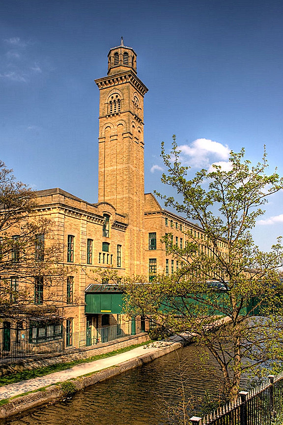
Saltaire
United Kingdom · 53.8372° N, 1.7903° W · 5 km from Bradford
Saltaire is a Victorian model village near Shipley, West Yorkshire, England, south of the River Aire, Salts Mill was built between the railway and the Leeds and Liverpool Canal. The mill and houses were built for Titus Salt between 1851 and 1871 to allow his workers to live in better conditions than the slums of Bradford. The mill ceased production in 1986 and was converted into a multifunctional location with an art gallery, restaurants, and the headquarters of a technology company. The model village is a UNESCO World Heritage Site and on the European Route of Industrial Heritage.
Adapted from Wikipedia: Saltaire (CC BY-SA 4.0).
Why Saltaire Is Listed
- (ii)
- An important interchange of human values.
- (iv)
- An outstanding example of a type of building or landscape.
More about Saltaire
UNESCO's Description
Saltaire, West Yorkshire, is a complete and well-preserved industrial village of the second half of the 19th century. Its textile mills, public buildings and workers' housing are built in a harmonious style of high architectural standards and the urban plan survives intact, giving a vivid impression of Victorian philanthropic paternalism.
From the UNESCO World Heritage Centre (CC BY-SA IGO 3.0).
History
Saltaire was commissioned in 1851 by Sir Titus Salt, a leading industrialist in the Yorkshire woollen industry. The name of the village is a combination of the founder's surname and the name of the river. Salt moved his business (five separate mills) from Bradford to this site near Shipley to arrange his workers and to site his large textile mill by the Leeds and Liverpool Canal and the railway. Salt employed the local architects Francis Lockwood and William Mawson.
Similar, but considerably smaller, projects had also been started around the same time by Edward Akroyd at Copley and by Henry Ripley at Ripley Ville. The cotton mill village of New Lanark, which is also a World Heritage site, was founded by David Dale in 1786.
Sections adapted from Wikipedia: Saltaire (CC BY-SA 4.0).

Kew Gardens
United Kingdom · 51.4789° N, 0.2936° W · 1 km² · 12 km from London
Kew Gardens is a botanic garden in southwest London founded in 1759 that houses the "largest and most diverse botanical and mycological collections in the world". Its living collections include some of the 27,000 taxa curated by Royal Botanic Gardens, Kew, while the herbarium, one of the largest in the world, has over 8.5 million preserved plant and fungal specimens. The library contains more than 750,000 volumes, and the illustrations collection contains more than 175,000 prints and drawings of plants. It is one of London's top tourist attractions and is a World Heritage Site.
Kew Gardens, together with the botanic gardens at Wakehurst in Sussex, are managed by the Royal Botanic Gardens, Kew, an internationally important botanical research and education institution that employs over 1,100 staff and is a non-departmental public body sponsored by the Department for Environment, Food and Rural Affairs.
The botanic gardens at Kew formally started in 1759, although they can be traced back to the exotic garden at Kew Park, formed by Henry, Lord Capell of Tewkesbury.
Adapted from Wikipedia: Kew Gardens (CC BY-SA 4.0).
Why Kew Gardens Is Listed
- (ii)
- An important interchange of human values.
- (iii)
- A unique testimony to a cultural tradition or civilisation.
- (iv)
- An outstanding example of a type of building or landscape.
More about Kew Gardens
UNESCO's Description
This historic landscape garden features elements that illustrate significant periods of the art of gardens from the 18th to the 20th centuries. The gardens house botanic collections (conserved plants, living plants and documents) that have been considerably enriched through the centuries. Since their creation in 1759, the gardens have made a significant and uninterrupted contribution to the study of plant diversity and economic botany.
From the UNESCO World Heritage Centre (CC BY-SA IGO 3.0).
History
The district of Kew consists mostly of the gardens, with a small surrounding community. Royal residences in the area which came to influence the layout and construction of the gardens began in 1299 when Edward I moved his court to a manor house in neighbouring Richmond, then called Sheen. That manor house was later abandoned. In 1501, Henry VII built Sheen Palace, which, renamed Richmond Palace, became his permanent royal residence.
Around the start of the 16th century, courtiers attending Richmond Palace settled in Kew and built large houses. Early royal residences at Kew included Mary Tudor's house, which was standing by 1522 when a driveway was built to connect it to the palace at Richmond.
Sections adapted from Wikipedia: Kew Gardens (CC BY-SA 4.0).

Cornwall and West Devon Mining Landscape
United Kingdom · 50.1361° N, 5.3836° W · 197 km² · 12 km from Penzance
The Cornwall and West Devon Mining Landscape is a World Heritage Site which includes select mining landscapes in Cornwall and West Devon in the south west of England. The site was added to the World Heritage List during the 30th Session of the UNESCO World Heritage Committee in Vilnius, July 2006. Following plans in 2011 to restart mining at South Crofty, and to build a supermarket at Hayle Harbour, the World Heritage Committee drafted a decision in 2014 to put the site on the List of World Heritage in Danger, but this was rejected at the 38th Committee Session at Doha, Qatar (July 2014), in favour of a follow-up reactive monitoring mission.
Adapted from Wikipedia: Cornwall and West Devon Mining Landscape (CC BY-SA 4.0).
Why Cornwall and West Devon Mining Landscape Is Listed
- (ii)
- An important interchange of human values.
- (iii)
- A unique testimony to a cultural tradition or civilisation.
- (iv)
- An outstanding example of a type of building or landscape.
More about Cornwall and West Devon Mining Landscape
UNESCO's Description
Much of the landscape of Cornwall and West Devon was transformed in the 18th and early 19th centuries as a result of the rapid growth of pioneering copper and tin mining. Its deep underground mines, engine houses, foundries, new towns, smallholdings, ports and harbours, and their ancillary industries together reflect prolific innovation which, in the early 19th century, enabled the region to produce two-thirds of the world’s supply of copper. The substantial remains are a testimony to the contribution Cornwall and West Devon made to the Industrial Revolution in the rest of Britain and to the fundamental influence the area had on the mining world at large. Cornish technology embodied in engines, engine houses and mining equipment was exported around the world. Cornwall and West Devon were the heartland from which mining technology rapidly spread.
From the UNESCO World Heritage Centre (CC BY-SA IGO 3.0).
History
Up to the mid-16th century, Devon produced approximately 25-40% of the amount of tin that Cornwall did but the total amount of tin production from both Cornwall and Devon during this period was relatively small. After the 1540s, Cornwall's production took off and Devon's production was only about between a ninth to a tenth of that of Cornwall. From the mid-16th century onwards, the Devon stannaries were worth very little in income to the King and were sidelined as such following the Supremacy of Parliament Act 1512 (this does not apply to the Stannaries of Cornwall).
The landscapes of Cornwall and West Devon were radically reshaped during the 18th and 19th centuries by deep-lode mining for copper and tin.
Sections adapted from Wikipedia: Cornwall and West Devon Mining Landscape (CC BY-SA 4.0).

Pontcysyllte Aqueduct and Canal
United Kingdom · 52.9721° N, 3.0873° W · 1 km² · 28 km from Chester
Situated in north-eastern Wales, the 18 kilometre long Pontcysyllte Aqueduct and Canal is a feat of civil engineering of the Industrial Revolution, completed in the early years of the 19th century. Covering a difficult geographical setting, the building of the canal required substantial, bold civil engineering solutions, especially as it was built without using locks. The aqueduct is a pioneering masterpiece of engineering and monumental metal architecture, conceived by the celebrated civil engineer Thomas Telford. The use of both cast and wrought iron in the aqueduct enabled the construction of arches that were light and d strong, producing an overall effect that is both monumental and elegant. The property is inscribed as a masterpiece of creative genius, and as a remarkable synthesis of expertise already acquired in Europe. It is also recognized as an innovative ensemble that inspired many projects all over the world.
Description from the UNESCO World Heritage Centre (CC BY-SA IGO 3.0).
Why Pontcysyllte Aqueduct and Canal Is Listed
- (i)
- A masterpiece of human creative genius.
- (ii)
- An important interchange of human values.
- (iv)
- An outstanding example of a type of building or landscape.

Forth Bridge
United Kingdom · 55.9984° N, 3.3876° W · 12 km from Edinburgh
The Forth Bridge is a cantilever railway bridge across the Firth of Forth in the east of Scotland, 9 miles (14 kilometres) west of central Edinburgh. Completed in 1890, it is considered a symbol of Scotland (having been voted Scotland's greatest man-made wonder in 2016), and is a UNESCO World Heritage Site. It was designed by English engineers Sir John Fowler and Sir Benjamin Baker. It is sometimes referred to as the Forth Rail Bridge (to distinguish it from the adjacent Forth Road Bridge), although this is not its official name.
Construction of the bridge began in 1882 and it was opened on 4 March 1890 by the Duke of Rothesay, the future Edward VII. The bridge carries the Edinburgh–Aberdeen line across the Forth between the villages of South Queensferry and North Queensferry and has a total length of 2,467 metres (8,094 ft). When it opened it had the longest single cantilever bridge span in the world, until 1919 when the single 1,801 ft (549 m) span Quebec Bridge in Canada was completed. It continues to be the world's second-longest single cantilever span, with two spans of 1,709 feet (521 m).
The bridge and its associated railway infrastructure are owned by Network Rail.
Adapted from Wikipedia: Forth Bridge (CC BY-SA 4.0).
Why Forth Bridge Is Listed
- (i)
- A masterpiece of human creative genius.
- (iv)
- An outstanding example of a type of building or landscape.
More about Forth Bridge
UNESCO's Description
This railway bridge, crossing the Forth estuary in Scotland, had the world’s longest spans ( 541 m ) when i t opened in 1890 . It remains one of the greatest cantilever trussed bridges and continues to carry passengers and freight. Its distinctive industrial aesthetic is the result of a forthright and unadorned display of its structural components. Innovative in style, materials and scale, the Forth Bridge marks an important milestone in bridge design and construction during the period when railways came to dominate long-distance land travel.
From the UNESCO World Heritage Centre (CC BY-SA IGO 3.0).
Later history
Before the opening of the Forth Bridge, the railway journey from London to Aberdeen had taken about 13 hours running from Euston and using the London and North Western Railway and Caledonian Railway on a west coast route. With competition opened along the east coast route from the Great Northern, North Eastern and North British railways and starting from King's Cross, unofficial racing took place between the two consortia, reducing the journey time to about 81⁄2 hours on the overnight runs. This reached a climax in 1895 with sensational daily press reports about the "Race to the North". When race fever subsided the journey times became around 101⁄2 hours.
Background
Before the construction of the bridge, ferries were used to cross the Firth. In 1806, a pair of tunnels, one for each direction, was proposed, and in 1818 James Anderson produced a design for a three-span suspension bridge close to the site of the present one. Calling for approximately 2,500 tonnes (2,500 long tons; 2,800 short tons) of iron, Wilhelm Westhofen said of it "and this quantity [of iron] distributed over the length would have given it a very light and slender appearance, so light indeed that on a dull day it would hardly have been visible, and after a heavy gale probably no longer to be seen on a clear day either".
Sections adapted from Wikipedia: Forth Bridge (CC BY-SA 4.0).

Gorham's Cave complex
United Kingdom · 36.1225° N, 5.3419° W · 3 km from Gibraltar
The steep limestone cliffs on the eastern side of the Rock of Gibraltar contain four caves with archaeological and paleontological deposits that provide evidence of Neanderthal occupation over a span of more than 100,000 years. This exceptional testimony to the cultural traditions of the Neanderthals is seen notably in evidence of the hunting of birds and marine animals for food, the use of feathers for ornamentation and the presence of abstract rock engravings. Scientific research on these sites has already contributed substantially to debates about Neanderthal and human evolution.
Description from the UNESCO World Heritage Centre (CC BY-SA IGO 3.0).
Why Gorham's Cave complex Is Listed
- (iii)
- A unique testimony to a cultural tradition or civilisation.

Jodrell Bank Observatory
United Kingdom · 53.2362° N, 2.3071° W · 28 km from Stoke
Jodrell Bank Observatory ( JOD-rəl) in Cheshire, England, hosts a number of radio telescopes as part of the Jodrell Bank Centre for Astrophysics at the University of Manchester. The observatory was established in 1945 by Bernard Lovell, a radio astronomer at the university, to investigate cosmic rays after his work on radar in the Second World War. It has since played an important role in the research of meteoroids, quasars, pulsars, masers, and gravitational lenses, and was heavily involved with the tracking of Soviet and US spacecraft of the Space Race.
The main telescope at the observatory is the Lovell Telescope. Its diameter of 250 ft (76 m) makes it the third largest steerable radio telescope in the world. There are three other active telescopes at the observatory; the Mark II and 42 ft (13 m) and 7 m diameter radio telescopes.
Jodrell Bank Observatory hosts the global headquarters of the Square Kilometre Array and is the base of the Multi-Element Radio Linked Interferometer Network (MERLIN), a National Facility run by the University of Manchester on behalf of the Science and Technology Facilities Council.
Adapted from Wikipedia: Jodrell Bank Observatory (CC BY-SA 4.0).
Why Jodrell Bank Observatory Is Listed
- (i)
- A masterpiece of human creative genius.
- (ii)
- An important interchange of human values.
- (iv)
- An outstanding example of a type of building or landscape.
- (vi)
- A direct association with events, ideas or beliefs of universal significance.
More about Jodrell Bank Observatory
UNESCO's Description
Located in a rural area of northwest England, free from radio interference, Jodrell Bank is one of the world's leading radio astronomy observatories. At the beginning of its use, in 1945, the property housed research on cosmic rays detected by radar echoes. This observatory, which is still in operation, includes several radio telescopes and working buildings, including engineering sheds and the Control Building. Jodrell Bank has had substantial scientific impact in fields such as the study of meteors and the moon, the discovery of quasars, quantum optics, and the tracking of spacecraft. This exceptional technological ensemble illustrates the transition from traditional optical astronomy to radio astronomy (1940s to 1960s), which led to radical changes in the understanding of the universe.
From the UNESCO World Heritage Centre (CC BY-SA IGO 3.0).

The Slate Landscape of Northwest Wales
United Kingdom · 53.1208° N, 4.1150° W · 33 km² · 80 km from Chester
The Slate Landscape of Northwest Wales illustrates the transformation that industrial slate quarrying and mining brought about in the traditional rural environment of the mountains and valleys of the Snowdon massif. The territory, extending from mountain-top to sea-coast, presented opportunities and constraints that were used and challenged by the large-scale industrial processes undertaken by landowners and capital investors, which reshaped the agricultural landscape into an industrial centre for slate production during the Industrial Revolution (1780-1914). The serial property comprises six components each encompassing relict quarries and mines, archaeological sites related to slate industrial processing, historical settlements, both living and relict, historic gardens and grand country houses, ports, harbours and quays, and railway and road systems illustrating the functional and social linkages of the relict slate industrial landscape. The property was internationally significant not only for the export of slates, but also for the export of technology and skilled workers from the 1780s to the early 20th century. It played a leading role in the field and constituted a model for other slate quarries in different parts of the world. It offers an important and remarkable example of interchange of materials, technology and human values.
Description from the UNESCO World Heritage Centre (CC BY-SA IGO 3.0).
Why The Slate Landscape of Northwest Wales Is Listed
- (ii)
- An important interchange of human values.
- (v)
- An outstanding example of traditional human settlement or land use.

Flow Country
United Kingdom · 58.3715° N, 3.6585° W · 1,870 km² · 106 km from Inverness
The Flow Country (Scottish Gaelic: Dùthaich nam Boglaichean) is a vast area of bog peatland in Caithness and Sutherland, northern Scotland. It is the largest blanket bog in Europe, and covers about 4,000 km2 (1,500 mi2). It is an area of deep peat, dotted with bog pools, and is a very important habitat for wildlife. As peat is largely made up of the remains of plants, which are themselves made up of carbon, it locks up large stores of carbon for thousands of years. This carbon would otherwise be released to the atmosphere and contribute to global warming. In 2024 the Flow Country was awarded World Heritage status by UNESCO on account of its unparalleled blanket bog habitat. It includes the Forsinard Flows National Nature Reserve and the Caithness and Sutherland Peatlands.
Adapted from Wikipedia: Flow Country (CC BY-SA 4.0).
Why Flow Country Is Listed
- (ix)
- An outstanding example of ongoing ecological and biological processes.
- (x)
- The most important natural habitats for conserving biodiversity.
More about Flow Country
UNESCO's Description
The serial property, located in the Highland Region of Scotland, is considered the most outstanding example of an actively accumulating blanket bog landscape. This peatland ecosystem, which has been accumulating for the past 9,000 years, provides a diversity of habitats home to a distinct combination of bird species and displays a remarkable diversity of features not found anywhere else on Earth. Peatlands play an important role in storing carbon and the property’s ongoing peat-forming ecological processes continue to sequester carbon on a very large scale, representing a significant research and educational resource.
From the UNESCO World Heritage Centre (CC BY-SA IGO 3.0).
Geology
The principal geological deposit within the area is of course peat but other Quaternary superficial deposits are recorded, principally those associated with the ice age such as till but also post-glacial alluvium. All of these overlie bedrock which originates during four distinct intervals of geological time; the Archaean to Palaeoproterozoic Lewisian gneiss, the Neoproterozoic Moine succession into which Ordovician to Silurian granite is intruded and the largely Devonian age Old Red Sandstone.
History
"Flow" is a Scots word for a bog or morass, possibly derived from Old Norse (compare the Icelandic word flói, which has the same meaning). The bogs of the Flow Country have been subject to human activity since the end of the last ice age. In the last 200 years, they have been affected by human activity, including sheep grazing and forestry.
In the 1970s and 1980s, government tax breaks incentivised commercial forestry operations which drained areas of the bogs and planted non-native conifers, damaging the bogs and causing loss of some of the peatland. In 1987 the Nature Conservancy Council (NCC) released a report in London that was highly critical of the foresters.
Sections adapted from Wikipedia: Flow Country (CC BY-SA 4.0).
Shared With Neighbouring Countries
These sites cross the border. Each is written up on the page of the country UNESCO lists first.


World Heritage in United Kingdom: Quick Answers
- How many UNESCO World Heritage Sites are in United Kingdom?
- United Kingdom has 33 World Heritage Sites: 27 cultural, 5 natural and 1 mixed. 2 of them are shared with a neighbouring country.
- What was the first World Heritage Site in United Kingdom?
- Castles and Town Walls of King Edward in Gwynedd, inscribed in 1986. The most recent is Flow Country, inscribed in 2024.
- What are the natural World Heritage Sites in United Kingdom?
- Giant's Causeway, St Kilda (mixed), Henderson Island, Gough and Inaccessible Islands, Jurassic Coast, Flow Country.
- Are any World Heritage Sites in United Kingdom in danger?
- None of the World Heritage Sites in United Kingdom is on UNESCO's List of World Heritage in Danger.