
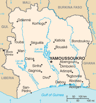
Map of Côte d'Ivoire
Côte d'Ivoire is a country in Africa with its capital at Yamoussoukro, home to about 32.71 million people across 322,463 km². The interactive map below plots 25 cities and towns, 8 rivers, 2 lakes, 1 mountain summits and 4 ports recorded for Côte d'Ivoire in YearMaps.
- Population
- 32.71 million
- Area
- 322,463 km²
- Capital
- Yamoussoukro
- Continent
- Africa
Interactive Map of Côte d'Ivoire
Centred on Yamoussoukro at 5.3219° N, 4.0420° W. Use the layer panel to switch on rivers, dams, ports, peaks and historical borders.
About Côte d'Ivoire
Ivory Coast, also known as Côte d'Ivoire and officially as the Republic of Côte d'Ivoire, is a country on the southern coast of West Africa. Its capital city of Yamoussoukro is located in the centre of the country, while its largest city and economic centre is the port city of Abidjan. It borders Guinea to the northwest, Liberia to the west, Mali to the north, Burkina Faso to the northeast, Ghana to the east, and the Atlantic Ocean's Gulf of Guinea to the south. With 33.2 million inhabitants in 2026, Ivory Coast is the third-most populous country in West Africa after Nigeria and Ghana. Its official language is French, and indigenous languages are also widely used, including Bété, Baoulé, Dyula, Dan, Anyin, and Cebaara Senufo. In total, there are around 78 languages spoken in Ivory Coast. The country has a religiously diverse population, including numerous followers of Islam, Christianity and traditional faiths often entailing animism.
Ivory Coast was traditionally home to several states, including Gyaaman, the Kong Empire, and Baoulé. The area became a protectorate of France in 1843 and was consolidated as a French colony in 1893 amid the Scramble for Africa. It achieved independence in 1960, led by Félix Houphouët-Boigny, who ruled the country until 1993. Relatively stable by regional standards, Ivory Coast established close political-economic ties with its West African neighbours while maintaining close relations with the West, especially France. Its stability was diminished by a coup d'état in 1999 and two civil wars—first between 2002 and 2007 and again during 2010–2011. It adopted a new constitution in 2016.
Ivory Coast is a republic with strong executive power vested in its president. Through the production of coffee and cocoa, it was an economic powerhouse in West Africa during the 1960s and 1970s, then experienced an economic crisis in the 1980s, contributing to a period of political and social turmoil that extended until 2011. Ivory Coast has again experienced high economic growth since the return of peace and political stability in 2011. From 2012 to 2023, the economy grew by an average of 7.1% per year in real terms, the second-fastest rate of economic growth in Africa and fourth-fastest rate in the world. In 2023, Ivory Coast had the second-highest GDP per capita in West Africa, behind Cape Verde. Despite this, as of the most recent survey in 2016, 46.1% of the population continues to be affected by multidimensional poverty. As of 2023, Ivory Coast is the world's largest exporter of cocoa beans and has high levels of income for its region.
Summary adapted from Wikipedia: Ivory Coast (CC BY-SA 4.0).

Geography and Climate of Côte d'Ivoire
Various small kingdoms ruled the area of Cote d'Ivoire between the 15th and 19th centuries, when European explorers arrived and then began to expand their presence. In 1844, France established a protectorate. During this period, many of these kingdoms and tribes fought to maintain their cultural identities -- some well into the 20th century. For example, the Sanwi kingdom -- originally founded in the 17th century -- tried to break away from Cote d’Ivoire and establish an independent state in 1969. Cote d’Ivoire achieved independence from France in 1960 but has maintained close ties. Foreign investment and the export and production of cocoa drove economic growth that led Cote d’Ivoire to become one of the most prosperous states in West Africa. Then in 1999, a military coup overthrew the government, and a year later, junta leader Robert GUEI held rigged elections and declared himself the winner. Popular protests forced him to step aside, and Laurent GBAGBO was elected. Ivoirian dissidents and members of the military launched a failed coup in 2002 that developed into a civil war. In 2003, a cease-fire resulted in rebels holding the north, the government holding the south, and peacekeeping forces occupying a buffer zone in the middle. In 2007, President GBAGBO and former rebel leader Guillaume SORO signed an agreement in which SORO joined GBAGBO's government as prime minister. The two agreed to reunite the country by dismantling the buffer zone, integrating rebel forces into the national armed forces, and holding elections. In 2010, Alassane Dramane OUATTARA won the presidential election, but GBAGBO refused to hand over power, resulting in five months of violent conflict. Armed OUATTARA supporters and UN and French troops eventually forced GBAGBO to step down in 2011. OUATTARA won a second term in 2015 and a controversial third term in 2020 -- despite the two-term limit in the Ivoirian constitution -- in an election boycotted by the opposition. Through political compromise with OUATTARA, the opposition participated peacefully in 2021 legislative elections and won a substantial minority of seats. Also in 2021, the International Criminal Court in The Hague ruled on a final acquittal for GBAGBO, who was on trial for crimes against humanity, paving the way for GBAGBO’s return to Abidjan the same year. GBAGBO has publicly met with OUATTARA since his return as a demonstration of political reconciliation.
- Location
- Western Africa, bordering the North Atlantic Ocean, between Ghana and Liberia.
- Climate
- Tropical along coast, semiarid in far north; three seasons - warm and dry (November to March), hot and dry (March to May), hot and wet (June to October)
- Terrain
- Mostly flat to undulating plains; mountains in northwest.
- Highest point
- Monts Nimba 1,752 m.
- Lowest point
- Gulf of Guinea 0 m.
- Coastline
- 515 km.
- Land borders
- Total: 3,458 km; border countries: Burkina Faso 545 km; Ghana 720 km; Guinea 816 km; Liberia 778 km; Mali 599 km.
- Major lakes
- Salt water lake(s): Lagune Aby - 780 sq km.
- Natural resources
- Petroleum, natural gas, diamonds, manganese, iron ore, cobalt, bauxite, copper, gold, nickel, tantalum, silica sand, clay, cocoa beans, coffee, palm oil, hydropower.
- Land use
- Agricultural land: 86.5% (2023 est.); arable land: 15.1% (2023 est.); permanent crops: 29.9% (2023 est.); permanent pasture: 41.5% (2023 est.); forest: 12.4% (2023 est.); other: 1.1% (2023 est.)
- Natural hazards
- Coast has heavy surf and no natural harbors; during the rainy season torrential flooding is possible.
- Geographic note
- Most of the inhabitants live along the sandy coastal region; apart from the capital area, the forested interior is sparsely populated.
- Languages
- French (official), 60 native dialects of which Dioula is the most widely spoken.
- Religions
- Muslim 42.9%, Catholic 17.2%, Evangelical 11.8%, Methodist 1.7%, other Christian 3.2%, animist 3.6%, other religion 0.5%, none 19.1% (2014 est.)
- Ethnic groups
- Akan 38%, Voltaique or Gur 22%, Northern Mande 22%, Kru 9.1%, Southern Mande 8.6%, other 0.3% (2021 est.)
- Economy
- One of West Africa’s most influential, stable, and rapidly developing economies; poverty declines in urban but increases in rural areas; strong construction sector and increasingly diverse economic portfolio; increasing but manageable public debt; large labor force in agriculture.
From the CIA World Factbook (public domain), archived edition of 2026-01-22. The Factbook is no longer updated, so figures reflect that edition.
Côte d'Ivoire in Numbers
- Population
- 32.71 million
- GDP
- US$99.8 billion
- GDP per person
- US$3,050
- Life expectancy
- 62.1 years
- Population growth
- 2.40% a year
- Population density
- 100 per km²
- Urban population
- 54.5%
- Surface area
- 322,460 km²
- Forest cover
- 12.1%
- Arable land
- 15.7%
- Access to electricity
- 72.9%
- Internet users
- 41.4%
Indicators from World Bank Open Data (CC BY 4.0). The year under each figure is its reference year.
Côte d'Ivoire in Depth
History
The first human presence in Ivory Coast has been difficult to determine because human remains have not been well preserved in the country's humid climate. However, newly found weapon and tool fragments (specifically, polished axes cut from shale and remnants of cooking and fishing) have been interpreted as a possible indication of a large human presence during the Upper Paleolithic period (15,000 to 10,000 BC), or at the minimum, the Neolithic period.
The earliest known inhabitants of Ivory Coast have left traces scattered throughout the territory. Historians believe that they were all either displaced or absorbed by the ancestors of the present indigenous inhabitants, who migrated south into the area before the 16th century.
Geography
Ivory Coast is a country in western sub-Saharan Africa. It borders Liberia and Guinea in the west, Mali and Burkina Faso in the north, Ghana in the east, and the Gulf of Guinea (Atlantic Ocean) in the south. The country lies between latitudes 4° and 11°N, and longitudes 2° and 9°W. Around 64.8% of the land is agricultural land; arable land amounted to 9.1%, permanent pasture 41.5%, and permanent crops 14.2%. Water pollution is one of the biggest issues that the country is currently facing.
There are over 1,200 animal species including 223 mammals, 702 birds, 161 reptiles, 85 amphibians, and 111 species of fish, alongside 4,700 plant species. It is the most biodiverse country in West Africa, with the majority of its wildlife population living in the nation's rugged interior.
Economy
Ivory Coast has, for the region, a relatively high income per capita (US$1,662 in 2017) and plays a key role in transit trade for neighbouring landlocked countries. As of the most recent survey in 2016, 46.1% of the population continues to be affected by multidimensional poverty. The country is the largest economy in the West African Economic and Monetary Union, constituting 40% of the monetary union's total GDP. Ivory Coast is the fourth-largest exporter of general goods in sub-Saharan Africa (following South Africa, Nigeria, and Angola).
The country is the world's largest exporter of cocoa beans. In 2009, cocoa-bean farmers earned $2.53 billion for cocoa exports and were projected to produce 630,000 metric tons in 2013.
Demographics
According to the 14 December 2021 census, the population was 29,389,150, up from 22,671,331 at the 2014 census. The first national census in 1975 counted 6.7 million inhabitants. According to a Demographic and Health Surveys nationwide survey, the total fertility rate stood at 4.3 children per woman in 2021 (with 3.6 in urban areas and 5.3 in rural areas), down from 5.0 children per woman in 2012.
It is estimated that 78 languages are spoken in Ivory Coast. French, the official language, is taught in schools and serves as a lingua franca.
Sections adapted from Wikipedia: Ivory Coast (CC BY-SA 4.0).
Côte d'Ivoire: Key Facts
| Currency | West African CFA franc |
|---|---|
| Official language | French |
| Head of state | Alassane Ouattara |
| Head of government | Robert Beugré Mambé |
| Form of government | republic |
| Calling code | +225 |
| Internet domain | .ci |
| Highest point | Mount Richard-Molard |
| Lowest point | Gulf of Guinea |
| Established | 1960 |
Facts from Wikidata Q1008 (CC0).
History of Côte d'Ivoire: Empires and States
The atlas records 6 polities whose mapped territory included part of Côte d'Ivoire, from Ashanti Empire in 1744 CE to 2024 CE. They are listed in the order they first appear.
| Polity | Period here | Extent |
|---|---|---|
| Ashanti Empire | 1744–1894 CE | A small part |
| French Third Republic | 1890–1939 CE | Nearly all |
| French Africa | 1890–1957 CE | Nearly all |
| The French Colonial Empire | 1890–1957 CE | Nearly all |
| French Fourth Republic | 1945–1957 CE | Nearly all |
| Republic of Côte d'Ivoire | 1961–2024 CE | Nearly all |
Historical Maps of Côte d'Ivoire
Côte d'Ivoire on the world map in each year one of these states held it:
Derived by testing mapped cities against dated territorial polygons. Dates are when the polygons cover this place, not the polity's whole lifespan, and polities absent from the source dataset are not listed.
Largest Cities in Côte d'Ivoire
25 cities recorded. Ranked by metropolitan population. A port city's harbour is written up on the page of its sea.
| # | Name | Population | Region | Role |
|---|---|---|---|---|
| 1 | Abidjan | 3.80 million | Lagunes | National capital |
| 2 | Bouaké | 567,481 | Vallée du Bandama | Admin-1 capital |
| 3 | Daloa | 255,168 | Haut-Sassandra | Admin-1 capital |
| 4 | San-Pedro | 210,273 | Bas-Sassandra | Admin-1 capital |
| 5 | Yamoussoukro | 206,499 | Lacs | National capital |
| 6 | Korhogo | 177,711 | Savanes | Admin-1 capital |
| 7 | Man | 146,974 | Dix-Huit Montagnes | Admin-1 capital |
| 8 | Divo | 127,867 | Sud-Bandama | Admin-1 capital |
| 9 | Gagnoa | 123,184 | Fromager | Admin-1 capital |
| 10 | Soubré | 108,933 | Bas-Sassandra | Admin-1 capital |
| 11 | Abengourou | 104,020 | Moyen-Comoe | Admin-1 capital |
| 12 | Agboville | 81,770 | Agnéby | Admin-1 capital |
| 13 | Grand Bassam | 73,772 | Lagunes | Populated place |
| 14 | Dabou | 72,913 | Lagunes | Populated place |
| 15 | Dimbokro | 67,349 | N'zi-Comoé | Admin-1 capital |
| 16 | Ferkessédougou | 62,008 | Savanes | Populated place |
| 17 | Bouaflé | 60,962 | Marahoué | Admin-1 capital |
| 18 | Bondoukou | 58,297 | Zanzan | Admin-1 capital |
| 19 | Séguéla | 51,157 | Worodougou | Admin-1 capital |
| 20 | Odienné | 49,857 | Denguélé | Admin-1 capital |
| 21 | Guiglo | 39,134 | Moyen-Cavally | Admin-1 capital |
| 22 | Toumodi | 39,005 | Lacs | Admin-1 capital |
| 23 | Sassandra | 38,411 | Bas-Sassandra | Populated place |
| 24 | Aboisso | 37,654 | Sud-Comoé | Admin-1 capital |
| 25 | Touba | 27,504 | Bafing | Admin-1 capital |
Highest Mountains in Côte d'Ivoire
1 mountain recorded. Ranked by summit elevation above sea level. A summit on a border is listed under both countries.
| # | Name | Elevation | Feet | Region |
|---|---|---|---|---|
| 1 | Mount Richard-Molard | 1,752 m | 5,748 ft | Africa |

Mount Richard-Molard
Mountain · 1,752 m
Mount Richard-Molard is a mountain rising to 1,752 metres (5,748 ft) in Guinea and Côte d'Ivoire, in the Africa region. The summit stands on the border between them.
Mount Richard-Molard is a mountain along the border of Guinea, Ivory Coast and Liberia in West Africa. The summit is on the border of Guinea and Ivory Coast and is the highest peak for both countries at 1,752 m (5,748 ft). The mountain is part of the Guinea Highlands, which straddles the borders between the three countries. The nearest major settlements are the town Yekepa in Liberia and the towns of Bossou and N'Zoo in Guinea.
Adapted from Wikipedia: Mount Richard-Molard (CC BY-SA 4.0).
- Elevation
- 1,752 m (5,748 ft)
- Global rank
- #459 of 641 indexed
- Region
- Africa (#69)
- Countries
- Guinea, Côte d'Ivoire
- Coordinates
- 7.6197°, -8.4138°
Of the 641 named summits indexed in YearMaps, Mount Richard-Molard ranks #459 by elevation, below Jabal Ramm (1,754 m) and above Mount Rogers (1,746 m).
- Ranges:
- Guinea Highlands (Africa), Loma Mountains (Africa)
Largest Lakes in Côte d'Ivoire
2 lakes recorded. Ranked by mapped surface area. A lake on a border is listed under each country it lies in, with the area of the whole lake.
| # | Name | Surface Area | Type |
|---|---|---|---|
| 1 | Lac de Kossou | 2,375 km² | Reservoir |
| 2 | Lac de Buyo | 999 km² | Reservoir |

Lac de Kossou
Reservoir · 2,375 km²
Lac de Kossou is an artificial reservoir in Côte d'Ivoire, with a mapped surface area of about 2,375 km². It exists because of a dam rather than natural drainage, and was filled in 1973.
Lake Kossou (French: Lac de Kossou) is Côte d'Ivoire's largest lake. It lies on the Bandama River in the center of the country. It is an artificial lake, created in 1973 by damming the Bandama River at Kossou (the Kossou Dam). Some 75,000 Baoulé people were displaced by the lake.
Adapted from Wikipedia: Lake Kossou (CC BY-SA 4.0).
- Surface area
- 2,375 km²
- Area rank
- #86 of 756 indexed
- Type
- Reservoir
- Country
- Côte d'Ivoire
- Impounded
- 1973
- Coordinates
- 7.1372°, -5.5362°
Among the 756 water bodies with a mapped extent in YearMaps, Lac de Kossou ranks #86 by surface area, after Réservoir de La Grande 3 (2,408 km²) and ahead of Hongze Hu (2,351 km²). Areas are computed from the mapped outline and are approximate.
- Settlements on the shore:
- Bouaflé (29 km), Yamoussoukro (46 km), Bouaké (83 km)
- Other water nearby:
- Lac de Buyo (999 km²), Lake Chad (1,293 km²)
More about Lac de Kossou
History
Lake Kossou was formed after construction of the Kossou Dam across the Bandama River which was completed in 1973. The Kossou Dam Project was completed under the auspices of the United Nations Development Programme, the agency involved being the Authorite de Valle du Bandama (ADV). It involved relocating about 75,000 people from 200 settlements, into 54 new villages which were built by ADV, 32 in the forest zone and 22 in the savanna zone. 22,000 people were resettled before water started to be impounded in 1971.
The dam is constructed of earth with rockfill, and is about 1,500 m (5,000 ft) long. The impounded water powers a hydroelectric power plant with a capacity of 174 megawatts.
Sections adapted from Wikipedia: Lake Kossou (CC BY-SA 4.0).
Lac de Kossou: Key Facts
| Surface elevation | 185 m |
|---|
Facts from Wikidata Q267679 (CC0).
Lac de Buyo
Reservoir · 999 km²
Lac de Buyo is an artificial reservoir in Côte d'Ivoire, with a mapped surface area of about 999 km². It exists because of a dam rather than natural drainage, and was filled in 1980.
Lake Buyo (French: Lac de Buyo) is an artificial lake in western Ivory Coast on the Sassandra River. It was formed by the construction of the Buyo Dam at Buyo in 1980.
The water quality of the lake has suffered from disposal of untreated effluents and overuse of fertilizers in the surrounding areas.
Adapted from Wikipedia: Lake Buyo (CC BY-SA 4.0).
- Surface area
- 999 km²
- Area rank
- #200 of 756 indexed
- Type
- Reservoir
- Country
- Côte d'Ivoire
- Impounded
- 1980
- Coordinates
- 6.5235°, -6.9759°
Among the 756 water bodies with a mapped extent in YearMaps, Lac de Buyo ranks #200 by surface area, after Bosten Hu (1,003 km²) and ahead of Réservoir Pipmuacan (996 km²). Areas are computed from the mapped outline and are approximate.
- Other water nearby:
- Lac de Kossou (2,375 km²), Lake Chad (1,293 km²)
More about Lac de Buyo
Lac de Buyo: Key Facts
| Surface elevation | 207 m |
|---|
Facts from Wikidata Q4809051 (CC0).
Rivers in Côte d'Ivoire
8 rivers recorded. Listed alphabetically. A river is listed where its mapped reach lies, so long rivers appear under more than one country.
Ports in Côte d'Ivoire
4 ports recorded. Ranked by approach channel depth, the figure that limits which ships can call. Harbours link to their write-up on the page of the sea or coast they lie on.
| # | Name | Channel Depth | Class | Sea | Max Vessel |
|---|---|---|---|---|---|
| 1 | San Pedro | 38.4 m | Very Small | Atlantic Coast of Africa | large vessels |
| 2 | Port Bouet | 5.5 m | Very Small | Atlantic Coast of Africa | large vessels |
| 3 | Espoir Marine Terminal | 5.5 m | Very Small | Atlantic Coast of Africa | large vessels |
| 4 | Baobab Marine Terminal | — | Very Small | Atlantic Coast of Africa | large vessels |
UNESCO World Heritage Sites in Côte d'Ivoire
5 World Heritage Sites recorded. Listed by year of inscription, earliest first. Sites shared with another country appear under each.
| # | Name | Inscribed | Type | Criteria |
|---|---|---|---|---|
| 1 | Mount Nimba Strict Nature Reserve | 1981 | Natural | (ix) (x) |
| 2 | Taï National Park | 1982 | Natural | (vii) (x) |
| 3 | Comoé National Park | 1983 | Natural | (ix) (x) |
| 4 | Historic town of Grand-Bassam | 2012 | Cultural | (iii) (iv) |
| 5 | Sudanese style mosques in northern Côte d'Ivoire | 2021 | Cultural | (ii) (iv) |
Mountain Ranges, Deserts and Landforms of Côte d'Ivoire
3 mountain ranges, deserts and other landforms recorded. Ranked by mapped area. Covers mountain ranges, deserts, plateaus, named glaciers, plains, basins, peninsulas and capes. One that crosses a border is listed under every country it lies in, with the area of the whole feature.
| # | Name | Area | Type | Region |
|---|---|---|---|---|
| 1 | Africa | 29.41M km² | Continent | Africa |
| 2 | Guinea Highlands | 80,421 km² | Range/mtn | Africa |
| 3 | Ivory Coast | 7,436 km² | Coast | Africa |

Guinea Highlands
Range/mtn · 80,421 km²
Guinea Highlands is a range/mtn in Africa, covering an estimated 80,421 km². It extends across Guinea, Côte d'Ivoire and Liberia.
The Guinea Highlands is a densely forested mountainous plateau extending from central Guinea through northern Sierra Leone and Liberia to western Ivory Coast. The highlands include a number of mountains, ranges and plateaus, including the Fouta Djallon highlands in central Guinea, the Loma Mountains in Sierra Leone, the Simandou and Kourandou massifs in southeastern Guinea, the Nimba Range at the border of Guinea, Liberia, and Ivory Coast, and the Monts du Toura in western Ivory Coast.
Adapted from Wikipedia: Guinea Highlands (CC BY-SA 4.0).
- Feature class
- Range/mtn
- Mapped extent
- 80,421 km²
- Size rank
- #51 of 216 mountain ranges
- Region
- Africa
- Countries
- Guinea, Côte d'Ivoire, Liberia
- Coordinates
- 8.4067°, -8.7723°
- Summits:
- Mount Richard-Molard (1,752 m)
- Adjacent ranges:
- Loma Mountains (Africa), Anti Atlas (Africa)
More about Guinea Highlands
Geography
In Guinea they are known as Dorsale Guinéenne. The highest peak in the region is Mount Bintumani in Sierra Leone, at 1,945 metres (6,381 ft). Other peaks include Sankan Biriwa (1,850 metres (6,070 ft)) in Sierra Leone and Mount Richard-Molard (Mount Nimba) (1,752 metres (5,748 ft)) on the border of Guinea and Ivory Coast. The highlands mostly lie between 300 and 500 metres (980 and 1,640 ft) above sea level.
The Guinea Highlands are the source of many of West Africa's rivers, including the Niger River, West Africa's longest river, the Senegal and Gambia rivers, and the rivers of Sierra Leone, Liberia, Maritime Guinea, and western Ivory Coast.
Ecology
The Guinea Highlands form the transition between the Western Guinean lowland forests, moist tropical rainforests that lie to the south between the Guinea Highlands and the Atlantic Ocean, and the Guinean forest-savanna mosaic to the north.
The Guinean montane forests ecoregion covers the portion of the highlands above 600 meters elevation. It includes montane forests, grasslands, and savannas, with a distinct flora and fauna from the surrounding lowlands.
Sections adapted from Wikipedia: Guinea Highlands (CC BY-SA 4.0).
Ivory Coast
Coast · 7,436 km²
Ivory Coast is a coast in Africa, covering an estimated 7,436 km².
Ivory Coast, also known as Côte d'Ivoire and officially as the Republic of Côte d'Ivoire, is a country on the southern coast of West Africa. Its capital city of Yamoussoukro is located in the centre of the country, while its largest city and economic centre is the port city of Abidjan. It borders Guinea to the northwest, Liberia to the west, Mali to the north, Burkina Faso to the northeast, Ghana to the east, and the Atlantic Ocean's Gulf of Guinea to the south. With 33.2 million inhabitants in 2026, Ivory Coast is the third-most populous country in West Africa after Nigeria and Ghana. Its official language is French, and indigenous languages are also widely used, including Bété, Baoulé, Dyula, Dan, Anyin, and Cebaara Senufo. In total, there are around 78 languages spoken in Ivory Coast. The country has a religiously diverse population, including numerous followers of Islam, Christianity and traditional faiths often entailing animism.
Ivory Coast was traditionally home to several states, including Gyaaman, the Kong Empire, and Baoulé. The area became a protectorate of France in 1843 and was consolidated as a French colony in 1893 amid the Scramble for Africa.
Adapted from Wikipedia: Ivory Coast (CC BY-SA 4.0).
- Feature class
- Coast
- Mapped extent
- 7,436 km²
- Size rank
- #125 of 231 landforms
- Region
- Africa
- Coordinates
- 4.3657°, -7.3432°
- Summits:
- Mount Richard-Molard (1,752 m), Mount Wuteve (1,380 m), Loma Mansa (1,945 m)
- Ranges:
- Guinea Highlands (Africa), Loma Mountains (Africa)
More about Ivory Coast
Geography
Ivory Coast is a country in western sub-Saharan Africa. It borders Liberia and Guinea in the west, Mali and Burkina Faso in the north, Ghana in the east, and the Gulf of Guinea (Atlantic Ocean) in the south. The country lies between latitudes 4° and 11°N, and longitudes 2° and 9°W. Around 64.8% of the land is agricultural land; arable land amounted to 9.1%, permanent pasture 41.5%, and permanent crops 14.2%. Water pollution is one of the biggest issues that the country is currently facing.
There are over 1,200 animal species including 223 mammals, 702 birds, 161 reptiles, 85 amphibians, and 111 species of fish, alongside 4,700 plant species. It is the most biodiverse country in West Africa, with the majority of its wildlife population living in the nation's rugged interior.
History
The first human presence in Ivory Coast has been difficult to determine because human remains have not been well preserved in the country's humid climate. However, newly found weapon and tool fragments (specifically, polished axes cut from shale and remnants of cooking and fishing) have been interpreted as a possible indication of a large human presence during the Upper Paleolithic period (15,000 to 10,000 BC), or at the minimum, the Neolithic period.
The earliest known inhabitants of Ivory Coast have left traces scattered throughout the territory. Historians believe that they were all either displaced or absorbed by the ancestors of the present indigenous inhabitants, who migrated south into the area before the 16th century.
Economy
Ivory Coast has, for the region, a relatively high income per capita (US$1,662 in 2017) and plays a key role in transit trade for neighbouring landlocked countries. As of the most recent survey in 2016, 46.1% of the population continues to be affected by multidimensional poverty. The country is the largest economy in the West African Economic and Monetary Union, constituting 40% of the monetary union's total GDP. Ivory Coast is the fourth-largest exporter of general goods in sub-Saharan Africa (following South Africa, Nigeria, and Angola).
The country is the world's largest exporter of cocoa beans. In 2009, cocoa-bean farmers earned $2.53 billion for cocoa exports and were projected to produce 630,000 metric tons in 2013.
Sections adapted from Wikipedia: Ivory Coast (CC BY-SA 4.0).
Ivory Coast: Key Facts
| Area | 322,463 km² |
|---|---|
| Highest point | Mount Richard-Molard |
| On | Atlantic Ocean |
Facts from Wikidata Q1008 (CC0).
Countries Bordering Côte d'Ivoire
Land and maritime neighbours.
More Maps in Africa
Côte d'Ivoire: Quick Answers
- What is the capital of Côte d'Ivoire?
- The capital of Côte d'Ivoire is Yamoussoukro.
- What is the population of Côte d'Ivoire?
- Côte d'Ivoire has a population of about 32.71 million, the #50 largest of 225 countries in YearMaps. Source: World Bank, 2025.
- How big is Côte d'Ivoire?
- Côte d'Ivoire covers 322,463 km², ranking #71 by area, with about 101 people per square kilometre.
- Which continent is Côte d'Ivoire in?
- Côte d'Ivoire is in Africa.
- Which countries border Côte d'Ivoire?
- Côte d'Ivoire shares a land or maritime border with Ghana, Mali, Burkina Faso, Guinea, Liberia.
- What is the largest city in Côte d'Ivoire?
- Abidjan is the largest city in Côte d'Ivoire, with a metropolitan population of about 3.80 million.
- What is the highest mountain in Côte d'Ivoire?
- The highest summit recorded for Côte d'Ivoire in YearMaps is Mount Richard-Molard at 1,752 m (5,748 ft). Summits on a border are counted for both countries.
- What is the largest lake in Côte d'Ivoire?
- The largest lake recorded in or bordering Côte d'Ivoire is Lac de Kossou, at roughly 2,375 km².