Skip to content
YearMaps
Micronesia · Islands

Largest Islands of Micronesia

Caroline Islands is the largest of the 5 islands recorded for Micronesia, at 1.75M km², ahead of Truk at 3,537 km². The full list follows.

How this list is built: Ranked by mapped area. An island divided between countries is listed under each, with the area of the whole island. It covers the islands indexed in YearMaps, drawn from open geospatial data, and is not an exhaustive national register.

Islands Listed
5
Top Ranked
1.75M km²
Caroline Islands
Second
3,537 km²
Truk
Profiled Below
5
Photo, encyclopedia text and figures
Largest Islands of Micronesia
#NameArea
1Caroline Islands1.75M km²
2Truk3,537 km²
3Yap Islands1,498 km²
4Pohnpei342 km²
5Oroluk84 km²

The Islands of Micronesia in Detail

The 5 islands above that have an encyclopedia article, in the same order, each with its photograph, figures and the places around it.

Caroline Islands
Image via Wikimedia Commons (author and licence on the file page).

Caroline Islands

Island group · 1.75M km²

Caroline Islands is an island group in Oceania (Micronesia), covering an estimated 1.75M km². It extends across Palau and Micronesia. It is the 6th-largest of the 445 islands with a mapped extent in YearMaps.

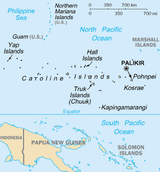
The Caroline Islands (or the Carolines) are a widely scattered archipelago of tiny islands in the western Pacific Ocean, to the north of New Guinea. Politically, they are divided between the Federated States of Micronesia (FSM) in the central and eastern parts of the group, and Palau at the extreme western end. Historically, this area was also called Nuevas Filipinas or New Philippines, because they were part of the Spanish East Indies and were governed from Manila in the Philippines.

The Carolines are scattered across a distance of approximately 3,540 kilometers (2,200 mi; 1,910 nmi), from the westernmost island, Tobi, in Palau, to the easternmost island, Kosrae, a state of the FSM.

Adapted from Wikipedia: Caroline Islands (CC BY-SA 4.0).

Feature class
Island group
Mapped extent
1.75M km²
Size rank
#6 of 445 islands
Region
Oceania
Subregion
Micronesia
Countries
Palau, Micronesia
Coordinates
4.3577°, 157.4944°
Ranges:
Owen Stanley Range (Oceania), New Guinea Highlands (Oceania)
Settlements:
Palikir (294 km)

View on the live map

More about Caroline Islands

History

Different islands in the Carolines have passed down different legends about the origins and early histories of their peoples. For example, on Pohnpei, the islanders describe their history before colonial times as divided into three eras: the Mwehin Kawa or Mwehin Aramas (era of building or peopling, before 1100); the Mwehin Sau Deleur (era of the reigns of the Saudeleur, from 1100 to around 1628); and the Mwehin Nahnmwarki (era of the tribal chiefs, from around 1628 to 1885, when Spain colonized the islands).

Description

The group consists of about 500 small coral islands, east of the Philippines, in the Pacific Ocean. The distance from Yap (one of the larger Caroline islands) to Manila is 1,200 mi (1,900 km).

Most of the islands are made up of low, flat coral atolls, but there are some that rise high above sea level.

Sections adapted from Wikipedia: Caroline Islands (CC BY-SA 4.0).

Caroline Islands: Key Facts

Key facts about Caroline Islands
Area1,160 km²
Population125,000 (2010)
Highest pointDolohmwar
Surrounded byPacific Ocean

Facts from Wikidata Q118350 (CC0).

Truk
Image via Wikimedia Commons (author and licence on the file page).

Truk

Island group · 3,537 km²

Truk is an island group in Oceania (Micronesia), covering an estimated 3,537 km².

Chuuk Lagoon, previously Truk Atoll, is an atoll in the central Pacific Ocean. It lies about 1,800 kilometres (970 nautical miles) northeast of New Guinea and is part of Chuuk State within the Federated States of Micronesia (FSM). A protective reef, 225 kilometres (140 mi) around, encloses a natural harbour 79 by 50 km (43 nmi × 27 nmi), with an area of 2,130 km2 (820 sq mi). It has a land area of 93.07 square kilometres (35.93 square miles), with a population of 36,158 people and a maximal elevation of 443 metres (1,453 ft). Weno city on Weno (formerly Moen) Island functions as both the atoll's capital and the state capital, and is the largest city in the FSM with its 13,700 people.

Chuuk Lagoon was the Empire of Japan's main naval base in the South Pacific theatre during World War II. It was the site of a major U.S. attack during Operation Hailstone in February 1944, and Operation Inmate, a small assault conducted by British and Canadian forces during June 1945.

Adapted from Wikipedia: Chuuk Lagoon (CC BY-SA 4.0).

Feature class
Island group
Mapped extent
3,537 km²
Size rank
#216 of 445 islands
Region
Oceania
Subregion
Micronesia
Coordinates
7.3542°, 151.7756°
Summits:
Mount Lamlam (406 m), Ulawun (2,334 m), Mount Balbi (2,715 m)
Ranges:
New Guinea Highlands (Oceania), Owen Stanley Range (Oceania)
Settlements:
Palikir (705 km), Agana (1,026 km), Wewak (1,512 km)

View on the live map

More about Truk

Geography

Chuuk Lagoon is part of the larger Caroline Islands group. The area consists of eleven major islands (corresponding to the eleven municipalities of Truk lagoon, which are Tol, Udot, Fala-Beguets, Romanum, and Eot of Faichuk group, and Weno, Fefen, Dublon, Uman, Param, and Tsis of Nomoneas group) and 46 smaller ones within the lagoon, plus 41 on the fringing coral reef, and is known today as the Chuuk islands, part of the Federated States of Micronesia in the Pacific Ocean.

History

It is not known when the islands of Chuuk were first settled, but archaeological evidence indicates that islands of Feefen and Wééné had human settlements in the first and second century BC. Later evidence indicates that widespread human settlements appeared in Chuuk during the 14th century AD.

The first recorded sighting by Europeans was made by Spanish navigator Álvaro de Saavedra on board the ship Florida during August or September 1528. They were later visited by Spaniard Alonso de Arellano on 15 January 1565 on board of galleon patache San Lucas.

As part of the Caroline Islands, Truk was claimed by the Spanish Empire, which made an effort to control the islands in the late 19th century.

Economy and infrastructure

Most of the roads and transportation systems are poor or in disrepair; an extensive infrastructural redevelopment plan began, consisting of a five-phase project to completely reconstruct the existing sewer, water and storm drainage systems as well as pour concrete roadways in the majority of the villages of Weno.

Chuuk International Airport (IATA airport code TKK) is on the administrative island of Weno. It is served by United Airlines.

The government operates a radio station. Interisland communication is often accomplished using citizens' band radio. Telephone services are limited on Chuuk, though a cellular network is established within some islands of the lagoon and in the near future on the outer islands.

Sections adapted from Wikipedia: Chuuk Lagoon (CC BY-SA 4.0).

Truk: Key Facts

Key facts about Truk
Area93.1 km²
Population41,745 (2022)
Surrounded byPacific Ocean

Facts from Wikidata Q3593555 (CC0).

Visiting Truk

Chuuk (previously known as Truk) is one of the four states of the Federated States of Micronesia. It is best known for wreck diving with few other reasons to visit.

Travel notes adapted from Wikivoyage: Chuuk (CC BY-SA 4.0).

Yap Islands
Image via Wikimedia Commons (author and licence on the file page).

Yap Islands

Island group · 1,498 km²

Yap Islands is an island group in Oceania (Micronesia), covering an estimated 1,498 km².

Yap (Yapese: Waqab, sometimes written as Wa'ab, Waab or Waqaab) traditionally refers to an island group located in the Caroline Islands of the western Pacific Ocean, a part of Yap State. The name "Yap" in recent years has come to also refer to the state within the Federated States of Micronesia, inclusive of the Yap Main Islands and its various outer islands, the Yap Neighboring Islands. For specifying the island group, the name Yap Main Islands is most exact.

Adapted from Wikipedia: Yap (CC BY-SA 4.0).

Feature class
Island group
Mapped extent
1,498 km²
Size rank
#271 of 445 islands
Region
Oceania
Subregion
Micronesia
Coordinates
9.5139°, 138.1019°
Summits:
Mount Lamlam (406 m), Mount Apo (2,954 m), Puncak Jaya (4,884 m)
Ranges:
Maoke Mountains (Oceania), New Guinea Highlands (Oceania)
Settlements:
Melekeok (444 km), Agana (847 km), Biak (1,209 km)

View on the live map

More about Yap Islands

Geography

Yap is made up of four separate islands: Yap Proper (Marbaaq, with the southern region referred to as Nimgil), Gagil-Tamil, Maap (Yapese: Maap'), and Rumung (the latter three collectively known as Marfach). The four islands are encircled by a common coral reef and are separated by relatively small water features. Gagil-Tamil and Yap Proper were once linked, but in 1901 a narrow canal called the Tagireeng Canal was built to cut the two landmasses apart.

Yap was formed from an uplift of the Philippine Sea Plate, and is referred to as a high island as opposed to atolls. The land is mostly rolling hills, with densely vegetated valleys and savanna interiors. Mangrove swamps line much of the shore, although there are beaches on the northern and western sides of the islands.

History

The first recorded sighting of Yap by Europeans came during the Spanish expedition of Álvaro de Saavedra in 1528. Its sighting was also recorded by the Spanish expedition of Ruy López de Villalobos on 26 January 1543, who charted them as "The Reefs" (Los Arrecifes). At Yap, the Villalobos expedition received the same surprising greeting as previously in Fais Island from the local people approaching the ships in canoes, crossing themselves and calling out "Buenos días Matelotes!" ("Hello, sailors!"), which they took for Spanish but more probably reflected the missionary efforts of António Galvão, governor of the Portuguese East Indies.

Sections adapted from Wikipedia: Yap (CC BY-SA 4.0).

Yap Islands: Key Facts

Key facts about Yap Islands
Area308 km²
Population11,377 (2010)
Surrounded byPacific Ocean

Facts from Wikidata Q209638 (CC0).

Pohnpei
Image via Wikimedia Commons (author and licence on the file page).

Pohnpei

Island · 342 km²

Pohnpei is an island in Oceania (Micronesia), covering an estimated 342 km².

Pohnpei (formerly known as Ponape or Ascension, from Pohnpeian: "upon (pohn) a stone altar (pei)") is an island of the Senyavin Islands which are part of the larger Caroline Islands group. It belongs to Pohnpei State, one of the four states in the Federated States of Micronesia (FSM). Major population centers on Pohnpei include Palikir, the FSM's capital, and Kolonia, the capital of Pohnpei State. Pohnpei is the largest island in the FSM, with an area of 334 km2 (129 sq mi), and a highest point of 782 m (2,566 ft), the most populous with 36,832 people, and the most developed single island in the FSM.

Pohnpei is home to the megaliths and ruined city of Nan Madol, built of artificial islands off the island's eastern shore beginning in the 8th or 9th century. An important archaeological site, it was declared a national historic site in 1985.

Pohnpei contains a wealth of biodiversity. It is one of the wettest places on Earth with annual recorded rainfall exceeding 7,600 mm (300 in) each year in certain mountainous locations. It is home to the ka tree (Terminalia carolinensis) found only in Pohnpei and Kosrae.

Adapted from Wikipedia: Pohnpei (CC BY-SA 4.0).

Feature class
Island
Mapped extent
342 km²
Size rank
#351 of 445 islands
Region
Oceania
Subregion
Micronesia
Coordinates
6.8894°, 158.2341°
Summits:
Mount Balbi (2,715 m), Takuan (2,243 m), Ulawun (2,334 m)
Ranges:
Owen Stanley Range (Oceania), New Guinea Highlands (Oceania)
Settlements:
Palikir (10 km), Majuro (1,451 km), Arawa (1,488 km)

View on the live map

More about Pohnpei

Geography

The highest point of the island is Mount Nanlaud at 772 or 782 metres. Pohnpei is home to several dozen bird species including four endemic species, the Pohnpei lorikeet, the Pohnpei fantail, the Pohnpei flycatcher and the long-billed white-eye. A fifth endemic, the Pohnpei starling, is thought to have recently gone extinct.

The only land reptiles are a few species of lizard. Originally the only mammals were bats. Pigs, rats and dogs were introduced; pigs have become feral. The lagoons are rich in fish, molluscs, turtles and other marine fauna.

Pohnpei belongs to the tropical rainforest climate zone (Köppen: Af).

History

The earliest settlers were probably Lapita culture people from the Southeast Solomon Islands or the Vanuatu archipelago. Pre-colonial history is divided into three eras: Mwehin Kawa or Mwehin Aramas (Period of Building, or Period of Peopling, before c. 1100); Mwehin Sau Deleur (Period of the Lord of Deleur, c. 1100 to c. 1628); and Mwehin Nahnmwarki (Period of the Nahnmwarki, c. 1628 to c. 1885). Pohnpeian legend recounts that the Saudeleur rulers, the first to bring government to Pohnpei, were of foreign origin. The Saudeleur centralized form of absolute rule is characterized in Pohnpeian legend as becoming increasingly oppressive over several generations. Arbitrary and onerous demands, as well as a reputation for offending Pohnpeian deities, sowed resentment among Pohnpeians.

Demographics

The population of the state in 2010 was approximately 36,196. While the majority of the population consider themselves ethnic Pohnpeians, Pohnpei is more ethnically diverse than any other island in the FSM. This is largely due to more than a century of foreign colonial occupation, bringing in Spanish, German, Japanese, Chamorro, Filipino, US, Australian, other western Europeans, and it being home to the capital of the national government, which employs hundreds of people from the other three FSM States (Yap, Chuuk, Kosrae) having distinct ethnic and cultural origins. The indigenous makeup also includes the multiple regional ethnicities of the outer islands within Pohnpei State, resulting in a mix of Australasian Pacific Islanders and hence making Pohnpei Island the FSM's melting pot.

Sections adapted from Wikipedia: Pohnpei (CC BY-SA 4.0).

Pohnpei: Key Facts

Key facts about Pohnpei
Area372 km²
Population26,102 (2023)
Highest pointDolohmwar
Surrounded byPacific Ocean

Facts from Wikidata Q319836 (CC0).

Oroluk
Image via Wikimedia Commons (author and licence on the file page).

Oroluk

Island · 84 km²

Oroluk is an island in Oceania (Micronesia), covering an estimated 84 km².

Oroluk Island is one of the islets of Oroluk Atoll, part of the State of Pohnpei (Federated States of Micronesia). The islet is 0.13 km2 in size. As of 2023, Oroluk has a small population consisting of 6 individuals. Previously, the main industries were agriculture and fishing.

Adapted from Wikipedia: Oroluk Island (CC BY-SA 4.0).

Feature class
Island
Mapped extent
84 km²
Size rank
#398 of 445 islands
Region
Oceania
Subregion
Micronesia
Coordinates
7.6327°, 155.1683°
Summits:
Mount Lamlam (406 m), Ulawun (2,334 m), Mount Balbi (2,715 m)
Ranges:
New Guinea Highlands (Oceania), Owen Stanley Range (Oceania)
Settlements:
Palikir (338 km), Agana (1,310 km), Arawa (1,542 km)

View on the live map

More about Oroluk

History

The Oroluk Atoll was discovered by Spanish navigator Alonso de Arellano in 1565 on board of the patache San Lucas, who charted it as Mira Cómo Vas (Look how you're going in Spanish). It was also later visited by the Spanish naval officer Felipe Tompson on 7 April 1773, who charted it as the Bajo Triste (the Sad Shoal in Spanish) due to its "horrible aspect" in his own words. Oroluk Island was charted by Tompson as San Agustín.

Sections adapted from Wikipedia: Oroluk Island (CC BY-SA 4.0).

Oroluk: Key Facts

Key facts about Oroluk
Area0.1 km²
Population0
Surrounded byPacific Ocean

Facts from Wikidata Q1521653 (CC0).

More on Micronesia

Quick Answers

What is the largest island in Micronesia?
Caroline Islands, at 1.75M km². Truk is second at 3,537 km². Rankings cover the islands indexed in YearMaps.
How many islands are there in Micronesia?
YearMaps lists 5 islands for Micronesia. This is the number mapped in the atlas, not an official national count.