
Map of Taiwan
Taiwan is a country in Asia with its capital at Taipei, home to about 23.32 million people across 36,193 km². The interactive map below plots 25 cities and towns, 1 mountain summits and 6 ports recorded for Taiwan in YearMaps.
- Population
- 23.32 million
- Area
- 36,193 km²
- Capital
- Taipei
- Continent
- Asia
Interactive Map of Taiwan
Centred on Taipei at 25.0358° N, 121.5683° E. Use the layer panel to switch on rivers, dams, ports, peaks and historical borders.
About Taiwan
Taiwan, officially the Republic of China (ROC), is a country in East Asia. The main island of Taiwan, formerly known as Formosa, lies between the East and South China Seas in the northwestern Pacific Ocean, with the People's Republic of China (PRC) to the northwest, Japan to the northeast, and the Philippines to the south. It has an area of 35,808 square kilometers (13,826 square miles), with mountain ranges dominating the eastern two-thirds and plains in the western third, where its highly urbanized population is concentrated. The combined territories under ROC control consist of 168 islands in total covering 36,193 square kilometers (13,974 square miles). The largest metropolitan area is formed by Taipei (the capital), New Taipei City, and Keelung. With around 23.9 million inhabitants, Taiwan is among the most densely populated countries.
Taiwan has been settled for at least 25,000 years. Ancestors of Taiwanese indigenous peoples settled the island around 6,000 years ago. In the 17th century, large-scale Han Chinese immigration began under Dutch colonial rule and continued under the Kingdom of Tungning, the first predominantly Han Chinese state in Taiwanese history. The island was annexed in 1683 by the Qing dynasty and ceded to the Empire of Japan in 1895. The Republic of China, controlled by Chiang Kai-shek and the Kuomintang (KMT), assumed control following the surrender of Japan in World War II. With the loss of mainland China to the Communists in the Chinese Civil War, the government of the Republic of China moved to Taiwan in 1949.
From the early 1960s, Taiwan saw rapid economic growth and industrialization known as the "Taiwan Miracle". In the late 1980s and early 1990s, the ROC transitioned from a one-party state under martial law to a multi-party democracy, with democratically elected presidents beginning in 1996. Taiwan's export-oriented economy is the 21st-largest in the world by nominal GDP and the 20th-largest by PPP measures, with a focus on steel, machinery, electronics, and chemicals manufacturing. Taiwan is a developed country. It is ranked highly in terms of civil liberties, healthcare, and human development.
The political and international status of Taiwan is contentious. Despite being a founding member, the ROC no longer represents China as a member of the United Nations after UN members voted in 1971 to recognize the PRC instead.
Summary adapted from Wikipedia: Taiwan (CC BY-SA 4.0).

Geography and Climate of Taiwan
First inhabited by Austronesian people, Taiwan became home to Han immigrants beginning in the late Ming Dynasty (17th century). In 1895, military defeat forced China's Qing Dynasty to cede Taiwan to Japan, which then governed Taiwan for 50 years. Taiwan came under Chinese Nationalist (Kuomintang, KMT) control after World War II. With the communist victory in the Chinese civil war in 1949, the Nationalist-controlled Republic of China government and 2 million Nationalists fled to Taiwan and continued to claim to be the legitimate government for mainland China and Taiwan, based on a 1947 constitution drawn up for all of China. Until 1987, however, the Nationalist Government ruled Taiwan under a civil war martial law declaration dating to 1948. Beginning in the 1970s, Nationalist authorities gradually began to incorporate the native population into the governing structure beyond the local level. The democratization process expanded rapidly in the 1980s, leading to the then-illegal founding of the Democratic Progressive Party (DPP), Taiwan’s first opposition party, in 1986 and the lifting of martial law the following year. Taiwan held legislative elections in 1992, the first in over 40 years, and its first direct presidential election in 1996. In the 2000 presidential elections, Taiwan underwent its first peaceful transfer of power with the KMT loss to the DPP and afterwards experienced two additional democratic transfers of power in 2008 and 2016. Throughout this period, the island prospered and turned into one of East Asia's economic "Tigers," becoming a major investor in mainland China after 2000 as cross-Strait ties matured. The dominant political issues continue to be economic reform and growth, as well as management of sensitive relations between Taiwan and China.
- Location
- Eastern Asia, islands bordering the East China Sea, Philippine Sea, South China Sea, and Taiwan Strait, north of the Philippines, off the southeastern coast of China.
- Climate
- Tropical; marine; rainy season during southwest monsoon (June to August); persistent and extensive cloudiness all year.
- Terrain
- Eastern two-thirds mostly rugged mountains; flat to gently rolling plains in west.
- Highest point
- Yu Shan 3,952 m.
- Lowest point
- South China Sea 0 m.
- Coastline
- 1,566.3 km.
- Land borders
- Total: 0 km.
- Natural resources
- Small deposits of coal, natural gas, limestone, marble, asbestos, arable land.
- Land use
- Agricultural land: 22% (2023 est.); arable land: 16.6% (2023 est.); permanent crops: 5.4% (2023 est.); permanent pasture: 0% (2022 est.); forest: 0% (2022 est.); other: 78% (2022 est.)
- Natural hazards
- Earthquakes; typhoons volcanism: Kueishantao Island (401 m), east of Taiwan, is the only historically active volcano, but it has not erupted in centuries.
- Geographic note
- Strategic location adjacent to both the Taiwan Strait and the Luzon Strait.
- Languages
- Mandarin (official), Min Nan, Hakka dialects, approximately 16 indigenous languages.
- Religions
- Buddhist 35.3%, Taoist 33.2%, Christian 3.9%, folk religion (includes Confucian) approximately 10%, none or unspecified 18.2% (2005 est.)
- Ethnic groups
- Han Chinese (including Holo, who compose approximately 70% of Taiwan's population, Hakka, and other groups originating in mainland China) more than 95%, indigenous Malayo-Polynesian peoples 2.3%.
- Economy
- High-income East Asian economy; most technologically advanced computer microchip manufacturing; increasing Chinese interference threatens market capabilities; minimum wages rising; longstanding regional socioeconomic inequality.
From the CIA World Factbook (public domain), archived edition of 2026-01-22. The Factbook is no longer updated, so figures reflect that edition.
Taiwan in Depth
History
Taiwan was joined to the Asian mainland in the Late Pleistocene, until sea levels rose about 10,000 years ago. Human remains and Paleolithic artifacts dated 20,000 to 30,000 years ago have been found. Study of the human remains suggested they were Australo-Papuan people similar to Negrito populations in the Philippines. Paleolithic Taiwanese likely settled the Ryukyu Islands 30,000 years ago although other studies suggest no genetic contribution from the aborigines of Taiwan into Ryukyuans. Slash-and-burn agriculture practices started at least 11,000 years ago.
Stone tools of the Changbin culture have been found in Taitung and Eluanbi. Archaeological remains suggest they were initially hunter-gatherers that slowly shifted to intensive fishing.
Geography
The land controlled by the ROC consists of 168 islands with a combined area of 36,193 square kilometers (13,974 sq mi). The main island, known historically as Formosa, makes up 99 percent of this area, measuring 35,808 square kilometers (13,826 sq mi) and lying some 180 kilometers (112 mi) across the Taiwan Strait from the southeastern coast of mainland China. The East China Sea lies to its north, the Philippine Sea to its east, the Luzon Strait directly to its south and the South China Sea to its southwest. Smaller islands include the Penghu Islands in the Taiwan Strait, the Kinmen, Matsu and Wuqiu islands near the Chinese coast, and some of the South China Sea islands.
Economy
The quick industrialization and rapid growth of Taiwan during the latter half of the 20th century has been called the "Taiwan Miracle". Taiwan is one of the "Four Asian Tigers" alongside Hong Kong, South Korea and Singapore. As of 2025, Taiwan is the 22nd largest economy in the world by nominal GDP.
Since 2001, agriculture has constituted less than 2 percent of GDP, down from 32 percent in 1951. Unlike its neighbors, South Korea and Japan, the Taiwanese economy is dominated by small and medium-sized enterprises, rather than the large business groups. Traditional labor-intensive industries are steadily being moved offshore, replaced by more capital- and technology-intensive industries. High-technology science parks have sprung up across Taiwan.
Demographics
Taiwan has a population of about 23.3 million, most of whom are on the island of Taiwan. The remainder live on the outlying islands of Penghu, Kinmen, and Matsu. It has one of the world's lowest fertility rates, with the average number of children born per woman falling below 0.8, far beneath the replacement level of 2.1 needed to maintain a stable population. Under United Nations criteria, Taiwan has become a super-aged society, with more than 20% of its population aged 65 or older.
Sections adapted from Wikipedia: Taiwan (CC BY-SA 4.0).
Taiwan: Key Facts
| Currency | New Taiwan dollar |
|---|---|
| Official languages | Standard Taiwanese Mandarin, Taiwanese Hakka, Taiwanese Hokkien, Amis, Paiwan |
| Head of state | Lai Ching-te |
| Head of government | Cho Jung-tai |
| Form of government | semi-presidential system, democracy |
| Calling code | +886 |
| Internet domain | .tw |
| Highest point | Yushan Main Peak |
| Established | 1 January 1912 |
Facts from Wikidata Q865 (CC0).
History of Taiwan: Empires and States
The atlas records 6 polities whose mapped territory included part of Taiwan, from The Spanish Empire in 1629 CE to 2024 CE. They are listed in the order they first appear.
| Polity | Period here | Extent |
|---|---|---|
| The Spanish Empire | 1629–1658 CE | A large part |
| Dutch Republic | 1636–1661 CE | Most |
| Southern Ming | 1662–1682 CE | Most |
| The Qing Dynasty | 1683–1894 CE | Most |
| Empire of Japan | 1895–1945 CE | Most |
| Republic of China | 1946–2024 CE | Most |
Historical Maps of Taiwan
Taiwan on the world map in each year one of these states held it:
Derived by testing mapped cities against dated territorial polygons. Dates are when the polygons cover this place, not the polity's whole lifespan, and polities absent from the source dataset are not listed.
Visiting Taiwan
Taiwan (Traditional Chinese: 台灣 or 臺灣, Táiwān) is a self-governing group of islands off the coast of China. It is one of the most densely populated places in the world. Besides its crowded cities, Taiwan is also known for steep mountains and lush forests. Taiwan is home to a large number of impressive scenic sites, and Taipei is a center of culture, entertainment and leisure activities. The island is also a center of Mandarin-language pop culture with a substantial entertainment industry.
Travel notes adapted from Wikivoyage: Taiwan (CC BY-SA 4.0).
Largest Cities in Taiwan
25 cities recorded. Ranked by metropolitan population. A port city's harbour is written up on the page of its sea.
| # | Name | Population | Region | Role |
|---|---|---|---|---|
| 1 | Taipei | 6.90 million | Taipei City | National capital |
| 2 | New Taipei | 3.89 million | New Taipei City | Admin-1 capital |
| 3 | Kaohsiung | 2.77 million | Kaohsiung City | Admin-1 capital |
| 4 | Taichung | 2.63 million | Taichung City | Admin-1 capital |
| 5 | Tainan | 1.88 million | Tainan City | Admin-1 capital |
| 6 | Zhongli | 1.63 million | Taoyuan | Populated place |
| 7 | Changhua | 750,000 | Changhua | Admin-1 capital |
| 8 | Hsinchu | 750,000 | Hsinchu City | Admin-1 capital |
| 9 | Pingtung | 503,530 | Pingtung | Admin-1 capital |
| 10 | Taoyuan | 500,000 | Taoyuan | Admin-1 capital |
| 11 | Keelung | 500,000 | Keelung City | Admin-1 capital |
| 12 | Chiayi | 500,000 | Chiayi City | Admin-1 capital |
| 13 | Hualien | 350,468 | Hualien | Admin-1 capital |
| 14 | Pingzhen | 201,632 | Taoyuan | Populated place |
| 15 | Zhubei | 200,000 | Hsinchu | Admin-1 capital |
| 16 | Yangmei | 175,000 | Taoyuan | Populated place |
| 17 | Taitung | 175,000 | Taitung | Admin-1 capital |
| 18 | Bade | 172,065 | Taoyuan | Populated place |
| 19 | Nantou | 165,000 | Nantou | Admin-1 capital |
| 20 | Yilan | 150,000 | Yilan | Admin-1 capital |
| 21 | Miaoli | 150,000 | Miaoli | Admin-1 capital |
| 22 | Douliou | 106,653 | Yunlin | Admin-1 capital |
| 23 | Magong | 56,435 | Penghu | Admin-1 capital |
| 24 | Puzi | 50,000 | Chiayi | Populated place |
| 25 | Taibao | 35,000 | Chiayi | Admin-1 capital |
Highest Mountains in Taiwan
1 mountain recorded. Ranked by summit elevation above sea level. A summit on a border is listed under both countries.
| # | Name | Elevation | Feet | Region |
|---|---|---|---|---|
| 1 | Yu Shan | 3,952 m | 12,966 ft | Asia |

Yu Shan
Mountain · 3,952 m
Yu Shan is a mountain rising to 3,952 metres (12,966 ft) in Taiwan, in the Asia region.
Yu Shan or Yushan, Tongku Saveq, Mount Niitaka (during Japanese rule), is the highest mountain in Taiwan at 3,952 m (12,966 ft) above sea level, giving Taiwan the 4th-highest maximum elevation of any island in the world. It is the highest point in the western Pacific region outside of the Kamchatka Peninsula. Yushan and its surrounding mountains belong to the Yushan Range. The area was once in the ocean; it rose to its current height because of the Eurasian Plate's movement over the Philippine Sea Plate. Yushan is ranked 40th by topographic isolation.
The mountains are now protected as the Yushan National Park. The national park is Taiwan's largest, highest, and least accessible national park. It contains the largest tract of wilderness remaining on the island.
Adapted from Wikipedia: Yushan (mountain) (CC BY-SA 4.0).
- Elevation
- 3,952 m (12,966 ft)
- Global rank
- #132 of 641 indexed
- Region
- Asia (#57)
- Country
- Taiwan
- Coordinates
- 23.4699°, 120.9574°
Of the 641 named summits indexed in YearMaps, Yu Shan ranks #132 by elevation, below Mount Robson (3,954 m) and above Kuh-e Taftan (3,941 m).
- Ranges:
- Wuyi Mountains (Asia), Dabie Mountains (Asia)
- Neighbouring summits:
- Tai Mo Shan (957 m), Pulog (2,934 m), Mount Pinatubo (1,486 m)
More about Yu Shan
Geography and geology
The island of Taiwan is situated at the intersection of two tectonic plates: the Eurasian Plate and the Philippine Sea Plate. Even as "recently" as the late Paleozoic (some 250 million years ago), the land here was still but a sedimentary seabed layered with silt and sand. As the two plates began pressing against each other, the land buckled, bent, and created the landscape – composed of 165 mountains higher than 3,000 m (9,800 ft) above sea level on a relatively small island (38th largest in the world).
Yushan is also notable in containing the highest point on the Tropic of Cancer and the only point on that circle of latitude where there is any evidence of Quaternary glaciation.
History
Under the Qing Dynasty, W. Morrison, captain of the American steam freighter Alexander, sighted the mountain while departing from Anping Harbor (present-day Anping, Tainan) in 1857. His log was the first western mention of the mountain, which took his name in European accounts. European mountaineers couldn't access the mountain at the time due to hostile relations of local aborigines to both Qing authorities and Europeans.
Under the Japanese, the anthropologists Torii Ryūzō and Ushinosuke Mori became the first people recorded to summit the mountain in 1900. They gave it the name "Mount Niitaka", which was used as the name of the Niitaka Arisan National Park (新高阿里山国立公園) in 1937.
Climate
Yushan has an alpine climate (Köppen ET/ETf). The tip of Yushan is usually covered with frost from November to March. Elevations above 2,000 metres (6,600 ft) may sometimes see snow during the winter months, and there are four consecutive months of snow accumulation at places with elevations higher than 3,000 metres (9,800 ft). The first snow may appear in October and completely melts by May. Snow falls 24.3 days per year on average on Yushan, and the number is gradually decreasing.
Yushan receives around 3,100 mm (120 in) of precipitation annually. It rains an average of 140 days per year, with the greatest frequency between May and August. From May until the first part of June is plum rain season or monsoon season. Taiwan's typhoon season roughly falls between July and September.
Sections adapted from Wikipedia: Yushan (mountain) (CC BY-SA 4.0).
Yu Shan: Key Facts
| Topographic prominence | 3,952 m |
|---|---|
| Mountain range | Yushan Range |
Facts from Wikidata Q500275 (CC0).
Ports in Taiwan
6 ports recorded. Ranked by approach channel depth, the figure that limits which ships can call. Harbours link to their write-up on the page of the sea or coast they lie on.
| # | Name | Channel Depth | Class | Sea | Max Vessel |
|---|---|---|---|---|---|
| 1 | Tan-Shui | 56.7 m | Very Small | Yellow Sea & East China Sea | medium vessels |
| 2 | Peng-Hu Kang | 42.1 m | Small | Yellow Sea & East China Sea | medium vessels |
| 3 | Hua-Lien Kang | 38.4 m | Minor | Yellow Sea & East China Sea | medium vessels |
| 4 | Tai-Chung Kang | 34.7 m | Small | Yellow Sea & East China Sea | medium vessels |
| 5 | Su-Ao | 27.4 m | Minor | Yellow Sea & East China Sea | medium vessels |
| 6 | Mailiao | 9.1 m | Very Small | Yellow Sea & East China Sea | point_of_interest |
Largest Islands of Taiwan
3 islands recorded. Ranked by mapped area. An island divided between countries is listed under each, with the area of the whole island.
| # | Name | Area | Type |
|---|---|---|---|
| 1 | Taiwan | 35,983 km² | Island |
| 2 | Paracel Islands | 21,227 km² | Island group |
| 3 | Sakishima Islands | 3,527 km² | Island group |
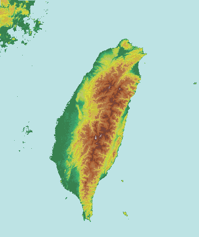
Taiwan
Island · 35,983 km²
Taiwan is an island in Asia, covering an estimated 35,983 km².
Taiwan, officially the Republic of China (ROC), is a country in East Asia comprising primarily the island of Taiwan, formerly known as Formosa, which has an area of 35,808 km2 (13,826 sq mi) and makes up 99% of the land under ROC control. It lies about 180 km (112 mi) across the Taiwan Strait from the southeastern coast of mainland China's Fujian Province. The East China Sea is to the north of the island, the Philippine Sea to its east, the Luzon Strait directly to its south, and the South China Sea to its southwest. The ROC also controls a number of smaller islands, including the Penghu archipelago in the Taiwan Strait, Kinmen and Matsu in Fuchien near the mainland coast, as well as Pratas and Taiping in the South China Sea.
Geologically, the main island comprises a tilted fault block, characterized by the contrast between the eastern two-thirds, consisting mostly of five rugged mountain ranges running parallel to the east coast, and the flat to gently rolling plains of the western third, where the majority of the population resides. Several peaks exceed 3,500 m in height – the highest, Yu Shan at 3,952 m (12,966 ft), makes Taiwan the world's fourth-highest island.
Adapted from Wikipedia: Geography of Taiwan (CC BY-SA 4.0).
- Feature class
- Island
- Mapped extent
- 35,983 km²
- Size rank
- #93 of 445 islands
- Region
- Asia
- Coordinates
- 23.5120°, 120.8043°
- Summits:
- Yu Shan (3,952 m), Tai Mo Shan (957 m), Pulog (2,934 m)
- Ranges:
- Wuyi Mountains (Asia), Dabie Mountains (Asia)
More about Taiwan
Human geography
Taiwan has a population of over 23 million, the vast majority of whom live in the lowlands near the western coast of the island.
The island is highly urbanized, with nearly 9 million people living in the Taipei–Keelung–Taoyuan metropolitan area at the northern end, and over 2 million each in the urban areas of Kaohsiung and Taichung.
Taiwanese indigenous peoples comprise approximately 2% of the population, and now mostly live in the mountainous eastern part of the island. Most scholars believe their ancestors arrived in Taiwan by sea between 4000 and 3000 BC, most likely from southeastern China.
Han Chinese make up over 95% of the population.
Geology
The island of Taiwan was formed approximately 4 to 5 million years ago at a complex convergent boundary between the Philippine Sea Plate and the Eurasian Plate. In a boundary running the length of the island and continuing southwards in the Luzon Volcanic Arc (including Green Island and Orchid Island), the Eurasian Plate is sliding under the Philippine Sea Plate.
The western part of the island, and much of the central range, consists of sedimentary deposits scraped from the descending edge of the Eurasian Plate. In the northeast of the island, and continuing eastwards in the Ryukyu Volcanic Arc, the Philippine Sea Plate slides under the Eurasian Plate.
Climate
The island of Taiwan lies across the Tropic of Cancer, and its climate is influenced by the East Asian monsoon. Northern Taiwan has a humid subtropical climate, with substantial seasonal variation of temperatures, while parts of central and most of southern Taiwan have a tropical monsoon climate where seasonal temperature variations are less noticeable, with temperatures typically varying from warm to hot. During the winter (November to March), the northeast experiences steady rain, while the central and southern parts of the island are mostly sunny. The summer monsoon (from May to October) accounts for 90% of the annual precipitation in the south, but only 60% in the north. The average rainfall is approximately 2,600 mm per year.
Sections adapted from Wikipedia: Geography of Taiwan (CC BY-SA 4.0).

Paracel Islands
Island group · 21,227 km²
Paracel Islands is an island group in Asia (South China Sea), covering an estimated 21,227 km². It extends across China, Vietnam and Taiwan.
The Paracel Islands, also known as the Xisha Islands (simplified Chinese: 西沙群岛; traditional Chinese: 西沙群島; pinyin: xīshā qúndǎo; lit. 'West Sand Archipelago') and the Hoàng Sa Archipelago (Vietnamese: Quần đảo Hoàng Sa; Chữ Hán: 羣島黃沙, lit. 'Yellow Sand Archipelago'), are an archipelago in the South China Sea. It is under the control of the People's Republic of China, but its sovereignty in whole or in part is disputed by Taiwan and Vietnam.
The word paracel is of Portuguese origin, meaning placer (a submerged bank or reef), and appears on 16th-century Portuguese maps. The archipelago includes about 130 small coral islands and reefs, most grouped into the northeastern Amphitrite Group or the western Crescent Group. They are distributed over a maritime area of around 15,000 square kilometers (5,800 sq mi), with a land area of approximately 7.75 square kilometers (2.99 sq mi). The archipelago is located about 220 miles (350 km) southeast of Hainan Island, equidistant from the coastlines of the People's Republic of China (PRC) and Vietnam, and approximately one-third of the way between central Vietnam and the northern Philippines.
Adapted from Wikipedia: Paracel Islands (CC BY-SA 4.0).
- Feature class
- Island group
- Mapped extent
- 21,227 km²
- Size rank
- #108 of 445 islands
- Region
- Asia
- Subregion
- South China Sea
- Countries
- China, Vietnam, Taiwan
- Coordinates
- 16.5464°, 112.1989°
- Summits:
- Yu Shan (3,952 m)
- Ranges:
- Dângrêk Range (Asia), Wuyi Mountains (Asia)
More about Paracel Islands
Geography
air mass. The air mass over the Paracel Islands has about a 5 °C (9.0 °F) variation in annual temperature compared to the 2.2 °C (4.0 °F) observed over the Spratly Islands.
The Amphitrite group was named after the French frigate Amphitrite, which observed the islands while carrying a Jesuit mission to Canton in 1698–1700.
Lying in the northeast of the Paracel Islands at 16°53′N 112°17′E, the group consists of low, narrow islands with sand cays and enclosed shallow lagoons connected by reefs of rock. It is about 37 km (23 mi) northwest of Lincoln Island. The group approximately forms an ellipse with a north–south axis of 22 km (14 mi).
Sections adapted from Wikipedia: Paracel Islands (CC BY-SA 4.0).
Paracel Islands: Key Facts
| Area | 7.8 km² |
|---|---|
| Surrounded by | South China Sea |
Facts from Wikidata Q274388 (CC0).
Visiting Paracel Islands
The Paracel Islands (Chinese: 西沙群岛, Xīshā Qúndǎo; Vietnamese: Quần đảo Hoàng Sa) are an archipelago in the South China Sea, administered by China as part of Hainan Province, but also claimed by Taiwan and Vietnam. They are a minor destination for patriotic Chinese citizens, not yet open to visitors from other countries.
Travel notes adapted from Wikivoyage: Paracel Islands (CC BY-SA 4.0).

Sakishima Islands
Island group · 3,527 km²
Sakishima Islands is an island group in Asia, covering an estimated 3,527 km².
The Sakishima Islands (Japanese: 先島諸島 / 先島群島, Hepburn: Sakishima-shotō / Sakishima-guntō; Okinawan: Sachishima; Miyako: Saksїzїma; Yaeyama: Sakїzїma; Yonaguni: Satichima) are an archipelago located at the southernmost end of the Japanese archipelago. They are part of the Ryukyu Islands and include the Miyako Islands and the Yaeyama Islands. The islands are administered as part of Okinawa Prefecture, Japan.
Adapted from Wikipedia: Sakishima Islands (CC BY-SA 4.0).
- Feature class
- Island group
- Mapped extent
- 3,527 km²
- Size rank
- #217 of 445 islands
- Region
- Asia
- Coordinates
- 24.5300°, 123.0389°
- Summits:
- Yu Shan (3,952 m), Pulog (2,934 m), Tai Mo Shan (957 m)
- Ranges:
- Wuyi Mountains (Asia), Dabie Mountains (Asia)
More about Sakishima Islands
History
The Sakishima Islands were first documented in the Shoku Nihongi (797), which says that in 714 Ō no Ason Okeji (太朝臣遠建治) paid tribute to Dazaifu with 52 islanders from Amami (奄美), Shigaki (信覚), Kumi (球美) and other islands. Shigaki is believed to be the current Ishigaki (石垣), Kumi to be the current Kume (久米) or Komi (古見) settlement of Iriomote. The History of Yuan (1370) documented a castaway from Mìyágǔ (密牙古) arrived to Wenzhou in 1317. This is believed to be the first documentation of Miyako (宮古).
Stone tools and shell tools from 2,500 years ago have been excavated from shell mounds on the Sakishima Islands. Shell tools of the same era are also found in Taiwan and the Philippines, but not on Okinawa Island or Amami.
Sections adapted from Wikipedia: Sakishima Islands (CC BY-SA 4.0).
Sakishima Islands: Key Facts
| Area | 818 km² |
|---|---|
| Population | 108,000 (2005) |
| Surrounded by | Pacific Ocean |
Facts from Wikidata Q697593 (CC0).
States and Provinces of Taiwan
1 first-level divisions with their own map.
Countries Bordering Taiwan
Land and maritime neighbours.
More Maps in Asia
Taiwan: Quick Answers
- What is the capital of Taiwan?
- The capital of Taiwan is Taipei.
- What is the population of Taiwan?
- Taiwan has a population of about 23.32 million, the #60 largest of 225 countries in YearMaps. Source: Wikidata.
- How big is Taiwan?
- Taiwan covers 36,193 km², ranking #139 by area, with about 644 people per square kilometre.
- Which continent is Taiwan in?
- Taiwan is in Asia.
- Which countries border Taiwan?
- Taiwan shares a land or maritime border with Japan, China, Philippines.
- What is the largest city in Taiwan?
- Taipei is the largest city in Taiwan, with a metropolitan population of about 6.90 million.
- What is the highest mountain in Taiwan?
- The highest summit recorded for Taiwan in YearMaps is Yu Shan at 3,952 m (12,966 ft). Summits on a border are counted for both countries.