Skip to content
YearMaps
Tanzania · Landforms

Mountain Ranges, Deserts and Landforms of Tanzania

Africa is the largest of the 6 mountain ranges, deserts and other landforms recorded for Tanzania, at 29.41M km², ahead of Iwembere Steppe at 284,281 km². The full list follows.

How this list is built: Ranked by mapped area. Covers mountain ranges, deserts, plateaus, named glaciers, plains, basins, peninsulas and capes. One that crosses a border is listed under every country it lies in, with the area of the whole feature. It covers the mountain ranges, deserts and other landforms indexed in YearMaps, drawn from open geospatial data, and is not an exhaustive national register.

Landforms Listed
6
Top Ranked
29.41M km²
Africa
Second
284,281 km²
Iwembere Steppe
Profiled Below
2
Photo, encyclopedia text and figures
Mountain Ranges, Deserts and Landforms of Tanzania
#NameArea
1Africa29.41M km²
2Iwembere Steppe284,281 km²
3Great Rift Valley163,247 km²
4Masai Steppe140,357 km²
5Serengeti Plains99,080 km²
6Great Rift Valley96,671 km²

The Landforms of Tanzania in Detail

The 2 mountain ranges, deserts and other landforms above that have an encyclopedia article, in the same order, each with its photograph, figures and the places around it.

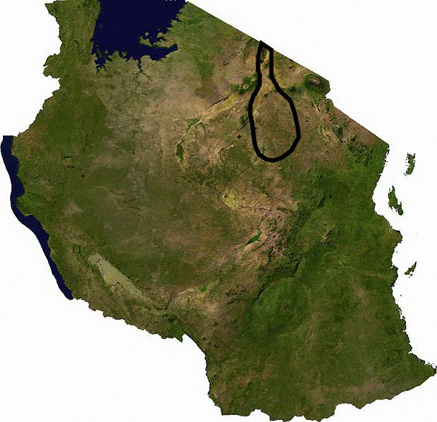
Masai Steppe
Image via Wikimedia Commons (author and licence on the file page).

Masai Steppe

Plain · 140,357 km²

Masai Steppe is a plain in Africa, covering an estimated 140,357 km².

The Tarangire Ecosystem () is a geographical region in northern Tanzania, Africa. It extends between 2.5 and 5.5 degrees south latitudes and between 35.5 and 37 degrees east longitudes.

The Tarangire Ecosystem hosts the second-largest population of migratory ungulates in East Africa and the largest population of elephants in northern Tanzania.

The Tarangire Ecosystem is defined by watershed boundaries of the Lake Manyara Basin and the Engaruka Basin, and the long distance migratory movements of eastern white-bearded wildebeest and plains zebra. It includes the dry season wildlife concentration area near the Tarangire River in Tarangire National Park, and the wet-season dispersal and calving grounds to the north in the Northern Plains and to the east in Simanjiro Plains, spanning in total approximately 20,500 km2 (7,900 sq mi). Migratory animals must have access to both the dry-season water source in the park, and the nutrient-rich forage available only on the calving grounds outside the park to successfully raise their calves and maintain their high abundance.

The Tarangire Ecosystem is also known as the Masai Steppe, or the Tarangire-Manyara Ecosystem.

Adapted from Wikipedia: Tarangire Ecosystem (CC BY-SA 4.0).

Feature class
Plain
Mapped extent
140,357 km²
Size rank
#54 of 231 landforms
Region
Africa
Coordinates
-5.1148°, 35.6203°
Summits:
Loolmalasin (3,682 m), Mount Kilimanjaro (5,895 m), Lesatima (4,001 m)
Ranges:
Ruwenzori Range (Africa), Inyanga Mountains (Africa)
Settlements:
Babati (101 km), Singida (103 km), Dodoma (120 km)

View on the live map

More about Masai Steppe

Geography and climate

The area falls within the eastern branch of the East African Rift Valley which has widened and the valley floor fallen over the past few million years. About 250,000 years ago Lake Manyara and Lake Burunge were part of a larger lake called Proto-Manyara, a basin of internal drainage that lost water through evaporation and deep percolation. Subsequent rises in the Rift Valley floor changed drainage patterns and the lake was reduced in size and divided into the two shallow, alkali lakes currently seen. Topography is now mainly low ridges of gneiss and pre-Cambrian rocks covered with well-drained, medium textured, stony soils. Large areas of valley bottoms are montmorillonite black cotton soils. Ancient lake sediments produced clay soils in the Proto-Manyara area.

History

Between the sixteenth and nineteenth centuries, the Maa-speaking pastoral people expanded into the area, replacing other pastoral groups like Nilotes and farming Bantu groups. By 1880 the Maasai reached their greatest extent. Around 1900 they suffered pleuro-pneumonia and smallpox diseases that killed many. At the same time the outbreak of the rinderpest decimated Maasai livestock and wildlife.

The colonial period of 1880s to 1950s saw the displacement of Maasai from lands with high potential for agricultural development by the European farmers/settlers. Many game parks were created at the same time, often evicting pastoralists from key dry season grazing areas and watering points.

Sections adapted from Wikipedia: Tarangire Ecosystem (CC BY-SA 4.0).

Serengeti Plains
Image via Wikimedia Commons (author and licence on the file page).

Serengeti Plains

Plain · 99,080 km²

Serengeti Plains is a plain in Africa, covering an estimated 99,080 km². It extends across Tanzania and Kenya.

The Serengeti ( SERR-ən-GHET-ee) is a geographical region in Africa, spanning the Mara and Arusha Regions of Tanzania and extending to southwestern Kenya. The protected area within the region includes approximately 30,000 km2 (12,000 sq mi) of land, including the Serengeti National Park and several game reserves. The Serengeti hosts one of the world's largest land animal migration (in terms of total body weight), which helps secure it as one of the Seven Natural Wonders of Africa.

The Serengeti is also renowned for its large lion population and is one of the best places to observe prides in their natural environment. Approximately 70 large mammal and 500 bird species are found there. This high diversity is a function of diverse habitats, including riverine forests, swamps, kopjes, grasslands, and woodlands. Blue wildebeest, gazelles, zebras, and buffalos are some of the commonly found large mammals in the region. The Serengeti also contains the Serengeti District of Tanzania.

The name "Serengeti" is often said to be derived from the word "seringit" in Maa, meaning "endless plains". However, this etymology does not appear in Maa dictionaries.

Adapted from Wikipedia: Serengeti (CC BY-SA 4.0).

Feature class
Plain
Mapped extent
99,080 km²
Size rank
#65 of 231 landforms
Region
Africa
Countries
Tanzania, Kenya
Coordinates
-3.0072°, 34.1303°
Summits:
Loolmalasin (3,682 m), Mount Kilimanjaro (5,895 m)
Ranges:
Ruwenzori Range (Africa), Ethiopian Highlands (Africa)
Settlements:
Shinyanga (122 km), Mwanza (134 km), Musoma (150 km)

View on the live map

More about Serengeti Plains

Ecology

The Serengeti has some of East Africa's finest wildlife areas. Besides being known for the great migration, the Serengeti is also famous for its abundant large predators. The ecosystem is home to over 3,000 lions, 1,000 African leopards, and 7,700 to 8,700 spotted hyenas (Crocuta crocuta). The East African cheetah is also present in Serengeti.

African wild dogs are relatively scarce in much of the Serengeti. This is particularly true in places such as Serengeti National Park (where they became extinct in 1992), in which lions and spotted hyenas, predators that steal wild dog kills and are a direct cause of wild dog mortality, are abundant.

History

For eons, African wildlife have roamed freely across the vast rolling plains of the Serengeti, which was sparsely inhabited by humans. This changed when nomadic pastoralists of the Maasai began to migrate to the area in the early 1800s.

The Maasai, however, were struck by drought and disease. Thousands died in the 1880s from a cholera epidemic and in 1892 from smallpox. Making matters worse, their cattle were wiped out by Rinderpest (a bovine viral disease). Later in the 20th century the Tanzanian government re-settled the Maasai around the Ngorongoro Crater. Poaching, and the absence of fires (which had been caused by humans), allowed dense woodlands and thickets to develop over the next 30–50 years. Tsetse fly populations now prevented any significant human settlement in the area.

Sections adapted from Wikipedia: Serengeti (CC BY-SA 4.0).

Serengeti Plains: Key Facts

Key facts about Serengeti Plains
Area30,000 km²
OnLake Victoria

Facts from Wikidata Q4991540 (CC0).

More on Tanzania

Quick Answers

What is the largest landform in Tanzania?
Africa, at 29.41M km². Iwembere Steppe is second at 284,281 km². Rankings cover the mountain ranges, deserts and other landforms indexed in YearMaps.
How many mountain ranges, deserts and other landforms are there in Tanzania?
YearMaps lists 6 mountain ranges, deserts and other landforms for Tanzania. This is the number mapped in the atlas, not an official national count.