
UNESCO World Heritage Sites in Mexico
Mexico has 32 sites on the UNESCO World Heritage List (26 cultural, 5 natural and 1 mixed), the first inscribed in 1987 (Historic Centre of Mexico City and Xochimilco). 1 site is on the List of World Heritage in Danger. The map below plots every one of them alongside the rest of the List, and each site is written up in full further down the page.
- World Heritage Sites
- 32
- Cultural
- 26
- Natural and Mixed
- 6
- First Inscribed
- 1987
Map of World Heritage Sites in Mexico
CulturalNaturalMixedIn DangerLarge dots are in Mexico. Click a dot to read about the site.

Historic Centre of Mexico City and Xochimilco
Mexico · 19.4183° N, 99.1328° W · 30 km² · 3 km from Mexico City
Built in the 16th century by the Spanish on the ruins of Tenochtitlan, the old Aztec capital, Mexico City is now one of the world's largest and most densely populated cities. It has five Aztec temples, the ruins of which have been identified, a cathedral (the largest on the continent) and some fine 19th- and 20th-century public buildings such as the Palacio de las Bellas Artes. Xochimilco lies 28 km south of Mexico City. With its network of canals and artificial islands, it testifies to the efforts of the Aztec people to build a habitat in the midst of an unfavourable environment. Its characteristic urban and rural structures, built since the 16th century and during the colonial period; have been preserved in an exceptional manner.
Description from the UNESCO World Heritage Centre (CC BY-SA IGO 3.0).
Why Historic Centre of Mexico City and Xochimilco Is Listed
- (ii)
- An important interchange of human values.
- (iii)
- A unique testimony to a cultural tradition or civilisation.
- (iv)
- An outstanding example of a type of building or landscape.
- (v)
- An outstanding example of traditional human settlement or land use.
Historic Centre of Oaxaca and Archaeological Site of Monte Albán
Mexico · 17.0619° N, 96.7217° W · 44 km² · 6 km from Oaxaca
Inhabited over a period of 1,500 years by a succession of peoples – Olmecs, Zapotecs and Mixtecs – the terraces, dams, canals, pyramids and artificial mounds of Monte Albán were literally carved out of the mountain and are the symbols of a sacred topography. The nearby city of Oaxaca, which is built on a grid pattern, is a good example of Spanish colonial town planning. The solidity and volume of the city's buildings show that they were adapted to the earthquake-prone region in which these architectural gems were constructed.
Description from the UNESCO World Heritage Centre (CC BY-SA IGO 3.0).
Why Historic Centre of Oaxaca and Archaeological Site of Monte Albán Is Listed
- (i)
- A masterpiece of human creative genius.
- (ii)
- An important interchange of human values.
- (iii)
- A unique testimony to a cultural tradition or civilisation.
- (iv)
- An outstanding example of a type of building or landscape.

Historic Centre of Puebla
Mexico · 19.0472° N, 98.2083° W · 7 km² · 1 km from Puebla
The historic centre of Puebla (Spanish: centro histórico de Puebla) was declared a World Heritage Site by UNESCO in 1987.
The Historic Monuments Zone of Puebla is considered the origin of Puebla. This Zone was decreed a Historic Monuments Zone in 1977 by presidential decree and 1 year later UNESCO declared it a World Heritage Site. The Historic Monuments Zone retains a lot of colonial buildings. Several of the oldest buildings were badly damaged in 1999 after the earthquake and later were subsequently repaired. After the 2017 earthquake, some of them again suffered damage.
Adapted from Wikipedia: Historic centre of Puebla (CC BY-SA 4.0).
Why Historic Centre of Puebla Is Listed
- (ii)
- An important interchange of human values.
- (iv)
- An outstanding example of a type of building or landscape.
More about Historic Centre of Puebla
UNESCO's Description
Puebla, which was founded ex nihilo in 1531, is situated about 100 km east of Mexico City, at the foot of the Popocatepetl volcano. It has preserved its great religious structures such as the 16th–17th-century cathedral and fine buildings like the old archbishop's palace, as well as a host of houses with walls covered in tiles ( azulejos ). The new aesthetic concepts resulting from the fusion of European and American styles were adopted locally and are peculiar to the Baroque district of Puebla.
From the UNESCO World Heritage Centre (CC BY-SA IGO 3.0).

Palenque
Mexico · 17.4842° N, 92.0464° W · 18 km² · 65 km from Tenosique
Palenque (Spanish pronunciation: [pa'leŋke]; Yucatec Maya: Bàakʼ [ɓaːkʼ]), also anciently known in the Itzaʼ language as Lakamha ("big water" or "big waters"), was a Maya city-state in southern Mexico that perished in the 8th century. The Palenque ruins date from ca. 226 BC to ca. 799 AD. After its decline, it was overgrown by the jungle of cedar, mahogany, and sapodilla trees, but has since been excavated and restored. It is located near the Usumacinta River in the Mexican state of Chiapas, about 130 km (81 mi) south of Ciudad del Carmen, 150 meters (490 ft) above sea level. It is adjacent to the modern town of Palenque, Chiapas. It averages a humid 26 °C (79 °F) with roughly 2,160 millimeters (85 in) of rain a year.
Palenque is a medium-sized site, smaller than Tikal, Chichen Itza, or Copán, but it contains some of the finest architecture, sculpture, roof comb and bas-relief carvings that the Maya produced.
Adapted from Wikipedia: Palenque (CC BY-SA 4.0).
Why Palenque Is Listed
- (i)
- A masterpiece of human creative genius.
- (ii)
- An important interchange of human values.
- (iii)
- A unique testimony to a cultural tradition or civilisation.
- (iv)
- An outstanding example of a type of building or landscape.
More about Palenque
UNESCO's Description
A prime example of a Mayan sanctuary of the classical period, Palenque was at its height between AD 500 and 700, when its influence extended throughout the basin of the Usumacinta River. The elegance and craftsmanship of the buildings, as well as the lightness of the sculpted reliefs with their Mayan mythological themes, attest to the creative genius of this civilization.
From the UNESCO World Heritage Centre (CC BY-SA IGO 3.0).
History
Mythological beings using a variety of emblem glyphs in their titles suggests a complex early history. For instance, Kʼukʼ Bahlam I, the supposed founder of the Palenque dynasty, is called a Toktan Ajaw in the text of the Temple of the Foliated Cross.
The famous structures that we know today probably represent a rebuilding effort in response to the attacks by the city of Calakmul and its client states in 599 and 611. One of the main figures responsible for rebuilding Palenque and for a renaissance in the city's art and architecture is also one of the best-known Maya Ajaw, Kʼinich Janaabʼ Pakal (Pacal the Great), who ruled from 615 to 683. He is known through his funerary monument dubbed the Temple of the Inscriptions, after the lengthy text preserved in the temple's superstructure.
Sections adapted from Wikipedia: Palenque (CC BY-SA 4.0).
Visiting Palenque
Located in Chiapas, the Mayan ruined city of Palenque stands out as one of the most beautiful and tourist-friendly of the Mayan cities. It has well developed tourist infrastructure with easy accessibility and a spectacular setting on a mountain in the midst of a rainforest. Beautiful architecture, unique in the Maya world, and well-preserved reliefs integrate with natural landscape to provide an educational tour with impact. Numerous discoveries were made in Palenque, defining a large chunk of the known history and mythology of the ancient Mayan culture. The site is still being actively explored and renown archaeologists from around the world come to research new theories about the Mesoamerican world.
Mythology names King U-Ch'ix-K'an as the ruler of Palenque in 993 BC, but the physical evidence found to date shows the city to have thrived between 226 BC and 800 AD. Either way, it's old. Set amidst thick trees, Palenque still evokes some of the wonder that the early Spanish visitors must have felt when they first came across the ruins.
Travel notes adapted from Wikivoyage: Palenque (CC BY-SA 4.0).

Sian Ka'an
Mexico · 19.3833° N, 87.7917° W · 5,280 km² · 35 km from Felipe Carrillo Puerto
Sian Kaʼan Biosphere Reserve (Spanish: Reserva de la Biósfera de Sian Kaʼan) is a biosphere reserve in Tulum Municipality in the Mexican state of Quintana Roo. It was established in 1986 and became a UNESCO World Heritage Site in 1987.
The term Sian Kaʼan, from the Yuatec Mayan language, "means 'gate of heaven' or 'a place where heaven begins.'"
By collaborating with scientists, technicians, students, fishermen, farmers, rural promoters and regional and international partners, more than 200 conservation projects have been carried out. Efforts have focused on eight protected natural areas that include the reefs of Banco Chinchorro, and Xcalak at South of Quintana Roo, Sian Kaʼan Biosphere Reserve, Cancún, the island of Cozumel that is located in front of Xcaret and Isla Contoy up north, covering 320,000 hectares (780,000 acres). These areas lie in parts of all seven Caribbean Sea coastal municipalities of the state, with the largest part being in eastern Felipe Carrillo Puerto, where the vast majority of Sian Kaʼan Biosphere Reserve lies.
Part of the reserve is on land and part is in the Caribbean Sea, including a section of coral reef.
Adapted from Wikipedia: Sian Kaʼan Biosphere Reserve (CC BY-SA 4.0).
Why Sian Ka'an Is Listed
- (vii)
- Superlative natural phenomena or exceptional natural beauty.
- (x)
- The most important natural habitats for conserving biodiversity.
More about Sian Ka'an
UNESCO's Description
In the language of the Mayan peoples who once inhabited this region, Sian Ka'an means 'Origin of the Sky'. Located on the east coast of the Yucatán peninsula, this biosphere reserve contains tropical forests, mangroves and marshes, as well as a large marine section intersected by a barrier reef. It provides a habitat for a remarkably rich flora and a fauna comprising more than 300 species of birds, as well as a large number of the region's characteristic terrestrial vertebrates, which cohabit in the diverse environment formed by its complex hydrological system.
From the UNESCO World Heritage Centre (CC BY-SA IGO 3.0).

Teotihuacan
Mexico · 19.6925° N, 98.8439° W · 3 km² · 31 km from Zumpango
Teotihuacan (; Spanish: Teotihuacán, Spanish pronunciation: [teotiwaˈkan] ; Classical Nahuatl: Teōtīhuacān, Classical Nahuatl pronunciation: [te.oːtiːˈwakaːn] ) is an ancient Mesoamerican city located in a sub-valley of the Valley of Mexico, which is located in the State of Mexico, 40 kilometers (25 mi) northeast of modern-day Mexico City.
Teotihuacan is known today as the site of many of the most architecturally significant Mesoamerican pyramids built in the pre-Columbian Americas, namely the Pyramid of the Sun and the Pyramid of the Moon. Although close to Mexico City, Teotihuacan was not a Mexica (i.e. Aztec) city, and it predates the Aztec Empire by many centuries. At its zenith, perhaps in the first half of the first millennium (1 CE to 500 CE), Teotihuacan was the largest city in the Americas. Its population has been estimated to be at least 25,000, but likely sat around 100,000 during its height, potentially making it the sixth-largest city in the world during its epoch.
The city covered twenty-one square kilometres (8 sq mi) and 80 to 90 percent of the total population of the valley resided in Teotihuacan.
Adapted from Wikipedia: Teotihuacan (CC BY-SA 4.0).
Why Teotihuacan Is Listed
- (i)
- A masterpiece of human creative genius.
- (ii)
- An important interchange of human values.
- (iii)
- A unique testimony to a cultural tradition or civilisation.
- (iv)
- An outstanding example of a type of building or landscape.
- (vi)
- A direct association with events, ideas or beliefs of universal significance.
More about Teotihuacan
UNESCO's Description
The holy city of Teotihuacan ('the place where the gods were created') is situated some 50 km north-east of Mexico City. Built between the 1st and 7th centuries A.D., it is characterized by the vast size of its monuments – in particular, the Temple of Quetzalcoatl and the Pyramids of the Sun and the Moon, laid out on geometric and symbolic principles. As one of the most powerful cultural centres in Mesoamerica, Teotihuacan extended its cultural and artistic influence throughout the region, and even beyond.
From the UNESCO World Heritage Centre (CC BY-SA IGO 3.0).
History
The first human establishment in the Teotihuacan area dates back to 600 BCE, and until 200 BCE the site consisted of scattered small villages. The total estimated population of the Teotihuacan Valley during this time was approximately 6,000. From 100 BCE to 750 CE, Teotihuacan evolved into a huge urban and administrative center with cultural influences throughout the broader Mesoamerica region.
Period I occurred between 200 – 1 BCE and marks the development of a distinctively urban area. During this period, Teotihuacan began to grow into a city as local farmers began coalescing around the abundant springs of Teotihuacan.
Period II lasted between 1 CE to 350 CE. During this era, Teotihuacan exhibited explosive growth and emerged as the largest metropolis in Mesoamerica.
Sections adapted from Wikipedia: Teotihuacan (CC BY-SA 4.0).
Key Facts
| Area | 2.5 km² |
|---|---|
| Architectural style | Talud-tablero |
Facts from Wikidata Q172613 (CC0).
Visiting Teotihuacan
Teotihuacan, also known as the City of the Gods, was the largest city in Pre-Columbian America. It is now an archeological site 40 km (25 mi) northeast of Mexico City, home to some of the largest ancient pyramids in the world. Náhuatl for "the place where men became gods", the Aztecs believed it was here where the gods gathered to plan the creation of man. It is a UNESCO World Heritage Site.
Travel notes adapted from Wikivoyage: Teotihuacan (CC BY-SA 4.0).

Chichen Itza
Mexico · 20.6831° N, 88.5686° W · 38 km from Valladolid
Chichen Itza was a large pre-Columbian city built by the Maya people of the Terminal Classic period. The archeological site is located in Tinúm Municipality, Yucatán, Mexico, between the cities of Valladolid and Mérida.
Chichen Itza was a major focal point in the Northern Maya Lowlands from the Late Classic (c. 600–900 AD) through the Terminal Classic (c. 800–900 AD) and into the early portion of the Postclassic period (c. 900–1200 AD). The site exhibits a multitude of architectural styles, reminiscent of styles seen in central Mexico and of the Puuc and Chenes styles of the Northern Maya lowlands. The presence of central Mexican styles was once thought to have been representative of direct migration or even conquest from central Mexico, but most contemporary interpretations view the presence of these non-Maya styles more as the result of cultural diffusion.
Chichen Itza was one of the largest Maya cities and it was likely to have been one of the mythical great cities, or Tollans, referred to in later Mesoamerican literature. The city may have had the most diverse population in the Maya world, a factor that could have contributed to the variety of architectural styles at the site.
Adapted from Wikipedia: Chichen Itza (CC BY-SA 4.0).
Why Chichen Itza Is Listed
- (i)
- A masterpiece of human creative genius.
- (ii)
- An important interchange of human values.
- (iii)
- A unique testimony to a cultural tradition or civilisation.
More about Chichen Itza
UNESCO's Description
This sacred site was one of the greatest Mayan centres of the Yucatán peninsula. Throughout its nearly 1,000-year history, different peoples have left their mark on the city. The Maya and Toltec vision of the world and the universe is revealed in their stone monuments and artistic works. The fusion of Mayan construction techniques with new elements from central Mexico make Chichen-Itza one of the most important examples of the Mayan-Toltec civilization in Yucatán. Several buildings have survived, such as the Warriors’ Temple, El Castillo and the circular observatory known as El Caracol.
From the UNESCO World Heritage Centre (CC BY-SA IGO 3.0).
History
The layout of Chichen Itza's core developed during its earlier phase of occupation, between 750 and 900 AD. Its final layout was developed after 900 AD, and the 10th century saw the rise of the city as a regional capital controlling the area from central Yucatán to the north coast, with its power extending down the east and west coasts of the peninsula. The earliest hieroglyphic date discovered at Chichen Itza is equivalent to 832 AD, while the last known date was recorded in the Osario temple in 998.
The Late Classic city was centered upon the area to the southwest of the Xtoloc cenote, with the main architecture represented by the substructures now underlying the Las Monjas and Observatorio and the basal platform upon which they were built.
Site description
Chichen Itza was one of the largest Maya cities, with the relatively densely clustered architecture of the site core covering an area of at least 5 square kilometers (1.9 sq mi). Smaller scale residential architecture extends for an unknown distance beyond this. The city was built upon broken terrain, which was artificially levelled in order to build the major architectural groups, with the greatest effort being expended in the levelling of the areas for the Castillo pyramid, and the Las Monjas, Osario and Main Southwest groups.
The site contains many fine stone buildings in various states of preservation, and many have been restored. The buildings were connected by a dense network of paved causeways, called sacbeob.
Location
Chichen Itza is located in the eastern portion of the Mexican state of Yucatán. The northern Yucatán Peninsula is karst, and the rivers in the interior all run underground. There are four visible, natural sink holes, called cenotes, that could have provided plentiful water year round at Chichén, making it attractive for settlement. Of these cenotes, the "Cenote Sagrado" or "Sacred Cenote" (also variously known as the Sacred Well or Well of Sacrifice), is the most famous. In 2015, scientists determined that there is a hidden cenote under the Temple of Kukulkan, which has never been seen by archeologists.
Economy
Chichen Itza was a major economic power in the northern Maya lowlands during its apogee. Participating in the water-borne circum-peninsular trade route through its port site of Isla Cerritos on the north coast, Chichen Itza was able to obtain locally unavailable resources from distant areas such as obsidian from central Mexico and gold from southern Central America.
Between 900 and 1050 AD Chichen Itza expanded to become a powerful regional capital controlling north and central Yucatán. It established Isla Cerritos as a trading port, which, along with another Northern Yucatan port Vista Alegre, acted as the main centers of a complex maritime market system dominated by Chichen Itza.
Sections adapted from Wikipedia: Chichen Itza (CC BY-SA 4.0).
Visiting Chichen Itza
Chichén Itzá is the largest of the archaeological cities of the pre-Columbian Maya civilization in the Yucatán Peninsula of Mexico. It is one of Mexico's most visited tourist destinations. It was granted World Heritage Site status in 1988 by UNESCO World Heritage Site and was selected as one of the New Seven Wonders of the World.
While the ruins are amazing, you will probably be disappointed by the large number of vendors allowed in the park. The vendors certainly don't "ruin" the experience, but they do diminish it. They are ubiquitous, often loud, and sometimes aggressive. This is in contrast to other Mayan historical sites where vendors are prohibited (e.g. Tikal in Guatemala).
Travel notes adapted from Wikivoyage: Chichen Itza (CC BY-SA 4.0).

Historic Centre of Morelia
Mexico · 19.7000° N, 101.1833° W · 4 km² · 4 km from Morelia
Built in the 16th century, Morelia is an outstanding example of urban planning which combines the ideas of the Spanish Renaissance with the Mesoamerican experience. Well-adapted to the slopes of the hill site, its streets still follow the original layout. More than 200 historic buildings, all in the region's characteristic pink stone, reflect the town's architectural history, revealing a masterly and eclectic blend of the medieval spirit with Renaissance, Baroque and neoclassical elements. Morelia was the birthplace of several important personalities of independent Mexico and has played a major role in the country's history.
Description from the UNESCO World Heritage Centre (CC BY-SA IGO 3.0).
Why Historic Centre of Morelia Is Listed
- (ii)
- An important interchange of human values.
- (iv)
- An outstanding example of a type of building or landscape.
- (vi)
- A direct association with events, ideas or beliefs of universal significance.

Tajín Veracruz
Mexico · 20.4481° N, 97.3782° W · 2 km² · 15 km from Poza Rica de Hidalgo
El Tajín is a pre-Columbian archeological site in Veracruz, Mexico and is one of the largest and most important cities of the Classic era of Mesoamerica. A part of the Classic Veracruz culture, El Tajín flourished from 600 to 1200 AD and during this time numerous temples, palaces, ballcourts, and pyramids were built. No European seemed to have known of its existence until 1785, when a government inspector chanced upon the Pyramid of the Niches.
El Tajín, named after the Totonac rain god, was named a World Heritage site in 1992, due to its cultural importance and its architecture. This architecture includes the use of decorative niches and cement in forms unknown in the rest of Mesoamerica. Its best-known monument is the Pyramid of the Niches, but other important monuments include the Arroyo Group, the North and South Ballcourts and the palaces of Tajín Chico. In total there have been 20 ballcourts discovered at this site, (the last 3 being discovered in March 2013). Since the 1970s, El Tajin has been the most important archeological site in Veracruz for tourists, attracting 386,406 visitors in 2017.
Adapted from Wikipedia: El Tajín (CC BY-SA 4.0).
Why Tajín Veracruz Is Listed
- (iii)
- A unique testimony to a cultural tradition or civilisation.
- (iv)
- An outstanding example of a type of building or landscape.
More about Tajín Veracruz
UNESCO's Description
Located in the state of Veracruz, El Tajin was at its height from the early 9th to the early 13th century. It became the most important centre in north-east Mesoamerica after the fall of the Teotihuacan Empire. Its cultural influence extended all along the Gulf and penetrated into the Maya region and the high plateaux of central Mexico. Its architecture, which is unique in Mesoamerica, is characterized by elaborate carved reliefs on the columns and frieze. The 'Pyramid of the Niches', a masterpiece of ancient Mexican and American architecture, reveals the astronomical and symbolic significance of the buildings. El Tajin has survived as an outstanding example of the grandeur and importance of the pre-Hispanic cultures of Mexico.
From the UNESCO World Heritage Centre (CC BY-SA IGO 3.0).
History of the city
Chronology studies at Tajín and nearby sites show that the area has been occupied at least since 5600 BCE and show how nomadic hunters and gatherers eventually became sedentary farmers, building more complex societies prior to the rise of the city of El Tajin. The pace of this societal progression became more rapid with the rise of the neighboring Olmec civilization around 1150 BCE, although the Olmecs were never here in great numbers. It is unclear who built the city. Some argue in favor of the Totonacs and the Xapaneca; however, there is a significant amount of evidence that the area was populated by the Huastec at the time the settlement was founded in the 1st century CE Monumental construction started soon after and by 600 CE, El Tajín was a city.
History of its rediscovery
In 1785, an official by the name of Diego Ruiz stumbled upon the Pyramid of the Niches, whilst looking for clandestine tobacco plantings breaching the royal monopoly in this isolated area rarely visited by the authorities. He made a drawing of the pyramid and reported his find to a publication called Gaceta de Mexico. He claimed the natives had kept the place secret. The publication of the pyramid's existence in the Gaceta influenced academic circles in New Spain and Europe, attracting the attention of antiquarians José Antonio de Alzate y Ramírez and Ciriaco Gonazlez Carvajal, who wrote about it. It also gained the interest of several academics, who compared the pyramid with the constructions of ancient Rome.
Location
The site is located in Mexico in the highlands of the municipality of Papantla in modern-day Veracruz, not far from the city of Poza Rica, which lies northwest of the port and city of Veracruz. The city is set in the low rolling mountains that lead from the Sierra Madre Oriental to the Gulf coast near the Tecolutla River. In ancient times, this city was located in the northeast corner of what is called Mesoamerica, and controlled an area from between the Cazones and Tecolutla Rivers to the modern state of Puebla. The main city is defined by two streams which merge to form the Tlahuanapa Arroyo, a tributary of the Tecolutla River. These two streams provided the population's potable water.
Sections adapted from Wikipedia: El Tajín (CC BY-SA 4.0).
Visiting Tajín Veracruz
El Tajin (El Tajín) is in the state of Veracruz in Mexico. It is a UNESCO World Heritage Site.
El Tajin, Totonac for 'thunder' or 'lightning', is a group of sacred buildings where ceremonies and religious sporting events were held. First begun around AD 100, it was occupied and developed mainly around AD 600 to 900, and later abandoned. El Tajin was rediscovered by the Spanish in 1785.
Travel notes adapted from Wikivoyage: El Tajin (CC BY-SA 4.0).

Historic centre of Zacatecas
Mexico · 22.7667° N, 102.5500° W · 2 km² · 3 km from Zacatecas
Founded in 1546 after the discovery of a rich silver lode, Zacatecas reached the height of its prosperity in the 16th and 17th centuries. Built on the steep slopes of a narrow valley, the town has breathtaking views and there are many old buildings, both religious and civil. The cathedral, built between 1730 and 1760, dominates the centre of the town. It is notable for its harmonious design and the Baroque profusion of its façades, where European and indigenous decorative elements are found side by side.
Description from the UNESCO World Heritage Centre (CC BY-SA IGO 3.0).
Why Historic centre of Zacatecas Is Listed
- (ii)
- An important interchange of human values.
- (iv)
- An outstanding example of a type of building or landscape.

Rock Paintings of Sierra de San Francisco
Mexico · 27.6556° N, 112.9161° W · 1,826 km²
The Rock Paintings of Sierra de San Francisco are prehistoric rock art pictographs found in the Sierra de San Francisco mountain range in Mulegé Municipality of the northern region of Baja California Sur state, in Mexico.
Adapted from Wikipedia: Rock Paintings of Sierra de San Francisco (CC BY-SA 4.0).
Why Rock Paintings of Sierra de San Francisco Is Listed
- (i)
- A masterpiece of human creative genius.
- (iii)
- A unique testimony to a cultural tradition or civilisation.
More about Rock Paintings of Sierra de San Francisco
UNESCO's Description
From c. 100 B.C. to A.D. 1300, the Sierra de San Francisco (in the El Vizcaino reserve, in Baja California) was home to a people who have now disappeared but who left one of the most outstanding collections of rock paintings in the world. They are remarkably well-preserved because of the dry climate and the inaccessibility of the site. Showing human figures and many animal species and illustrating the relationship between humans and their environment, the paintings reveal a highly sophisticated culture. Their composition and size, as well as the precision of the outlines and the variety of colours, but especially the number of sites, make this an impressive testimony to a unique artistic tradition.
From the UNESCO World Heritage Centre (CC BY-SA IGO 3.0).
Geography
The pictographs are at around 250 sites, which are located east of the El Vizcaino Biosphere Reserve. Access to the paintings is difficult due to the isolated location, which also has helped to minimize vandalism and destruction of the out cropping.
The area has one of the largest concentrations of Pre-Columbian art on the Baja California Peninsula. It is known for the high quality, extent, variety and originality of human and animal representations, remarkable colors, and excellent state of preservation.
In 1989 the rock paintings of Sierra de San Francisco were nominated for, and in 1993 became, a World Heritage Site.
History
The pictographs are likely the artistic products of the Cochimi people in the Baja California peninsula. This group became culturally extinct in the nineteenth century but is comparatively well known through the writings of eighteenth-century Jesuit missionaries. These paintings on the roofs and walls of rock shelters in the Sierra de San Francisco were first discovered by Europeans in the eighteenth century by the Mexican Jesuit missionary José Mariano Rotea.
According to some native beliefs recorded by the Jesuits and others, the paintings were drawn by a race of giants—a supposition that has been discarded by scientific investigators since the late nineteenth century. This belief may have been suggested by the larger-than-life size of many of the human (as well as animal) figures.
Sections adapted from Wikipedia: Rock Paintings of Sierra de San Francisco (CC BY-SA 4.0).
Key Facts
| Area | 1,826 km² |
|---|
Facts from Wikidata Q552005 (CC0).

Monasteries on the slopes of Popocatépetl
Mexico · 18.9347° N, 98.8978° W · 36 km from Cuernavaca
The Earliest Monasteries on the Slopes of Popocatepetl (Spanish: Primeros Monasterios en las faldas del Popocatépetl) are sixteen early 16th-century monasteries which were built by the Augustinians, the Franciscans and the Dominicans in order to evangelize the areas south and east of the Popocatépetl volcano in central Mexico. These monasteries were recognized by the UNESCO as World Heritage Sites in 1994, because they served as the model for the early monastery and church buildings as well as evangelization efforts in New Spain and some points beyond in Latin America. These monasteries almost uniformly feature a very large atrium in front of a single nave church with a capilla abierta or open chapel. The atrium functioned as the meeting point between the indigenous peoples and the missionary friars, with mass for the newly converted held outdoors instead of within the church. This arrangement can be found repeated in other areas of Mexico as these friars continued to branch out over New Spain.
The sixteen monasteries are open to visitors, with eleven located in northern Morelos, three in the state of Puebla, and one in Tlaxcala.
Adapted from Wikipedia: Monasteries on the slopes of Popocatépetl (CC BY-SA 4.0).
Why Monasteries on the slopes of Popocatépetl Is Listed
- (ii)
- An important interchange of human values.
- (iv)
- An outstanding example of a type of building or landscape.
More about Monasteries on the slopes of Popocatépetl
UNESCO's Description
The Earliest 16th-Century Monasteries on the Slopes of Popocatepetl is a serial property with 15 component parts located in the states of Morelos, Puebla and Tlaxcala in Mexico, built as part of the evangelisation and colonisation of the northern territories of Mexico. They are in an excellent state of conservation and are good examples of the architectural style adopted by the first missionaries – Franciscans, Dominicans and Augustinians – who converted the indigenous populations to Christianity in the early 16th century. They also represent an example of a new architectural concept in which open spaces, including wide atria and posa chapels, are of renewed importance. The influence of this style is felt throughout the Mexican territory and even beyond its borders.
From the UNESCO World Heritage Centre (CC BY-SA IGO 3.0).
History
The monasteries are part of the history of the early evangelization of Mexico. The Franciscans were invited to come first by Hernán Cortés, followed shortly thereafter by the Dominicans and the Augustinians. After establishing themselves in Mexico City and in the rest of the Valley of Mexico, they evangelized the area south and east of the volcano. The missionaries included Juan de Tecto, Juan de Ayora and Pedro de Gante, the last of whom learned Nahuatl in order to communicate with the indigenous peoples. The first of the monasteries were built by the Franciscans in 1524, who founded the monasteries of Huejotzingo, Cuernavaca, Calpan and Tochimilco. The Dominicans followed in 1526, founding those in Oaxtepec, Tepoztlan, Tetela del Volcán and Hueyapan.
Sections adapted from Wikipedia: Monasteries on the slopes of Popocatépetl (CC BY-SA 4.0).
Key Facts
| Area | 0.2 km² |
|---|
Facts from Wikidata Q1141009 (CC0).

Historic Monuments Zone of Querétaro
Mexico · 20.5833° N, 100.3667° W · 3 km² · 6 km from Querétaro
The old colonial town of Querétaro is unusual in having retained the geometric street plan of the Spanish conquerors side by side with the twisting alleys of the Indian quarters. The Otomi, the Tarasco, the Chichimeca and the Spanish lived together peacefully in the town, which is notable for the many ornate civil and religious Baroque monuments from its golden age in the 17th and 18th centuries.
Description from the UNESCO World Heritage Centre (CC BY-SA IGO 3.0).
Why Historic Monuments Zone of Querétaro Is Listed
- (ii)
- An important interchange of human values.
- (iv)
- An outstanding example of a type of building or landscape.
Pre-Hispanic Town of Uxmal
Mexico · 20.3617° N, 89.7703° W · 21 km² · 25 km from Ticul
The Mayan town of Uxmal, in Yucatán, was founded c. A.D. 700 and had some 25,000 inhabitants. The layout of the buildings, which date from between 700 and 1000, reveals a knowledge of astronomy. The Pyramid of the Soothsayer, as the Spaniards called it, dominates the ceremonial centre, which has well-designed buildings decorated with a profusion of symbolic motifs and sculptures depicting Chaac, the god of rain. The ceremonial sites of Uxmal, Kabah, Labna and Sayil are considered the high points of Mayan art and architecture.
Description from the UNESCO World Heritage Centre (CC BY-SA IGO 3.0).
Why Pre-Hispanic Town of Uxmal Is Listed
- (i)
- A masterpiece of human creative genius.
- (ii)
- An important interchange of human values.
- (iii)
- A unique testimony to a cultural tradition or civilisation.

Hospicio Cabañas
Mexico · 20.6769° N, 103.3373° W · 1 km from Guadalajara
The Hospicio Cabañas (Spanish pronunciation: [osˈpisjo kaˈβaɲas]) or Cabañas Museum in Guadalajara, Jalisco was one of the oldest and largest orphanage and hospital complexes in the Americas. Now turned into a museum, the main hall hosts the magnum opus frescoes of muralist painter José Clemente Orozco. The place was designated a UNESCO World Heritage Site in 1997.
Adapted from Wikipedia: Hospicio Cabañas (CC BY-SA 4.0).
Why Hospicio Cabañas Is Listed
- (i)
- A masterpiece of human creative genius.
- (ii)
- An important interchange of human values.
- (iii)
- A unique testimony to a cultural tradition or civilisation.
- (iv)
- An outstanding example of a type of building or landscape.
More about Hospicio Cabañas
UNESCO's Description
The Hospicio Cabañas was built at the beginning of the 19th century to provide care and shelter for the disadvantaged – orphans, old people, the handicapped and chronic invalids. This remarkable complex, which incorporates several unusual features designed specifically to meet the needs of its occupants, was unique for its time. It is also notable for the harmonious relationship between the open and built spaces, the simplicity of its design, and its size. In the early 20th century, the chapel was decorated with a superb series of murals, now considered some of the masterpieces of Mexican art. They are the work of José Clemente Orozco, one of the greatest Mexican muralists of the period.
From the UNESCO World Heritage Centre (CC BY-SA IGO 3.0).
History
The complex was founded in 1810 by the Bishop of Guadalajara in order to combine the functions of a workhouse, hospital, orphanage, and almshouse. It owes its name to Juan Ruiz de Cabañas who was appointed to the see of Guadalajara in 1796 and engaged Manuel Tolsá, a renowned architect from Mexico City, to design the structure.
Tolsá's design was based on classic examples such as Les Invalides in Paris and El Escorial near Madrid. The buildings form a rectangle measuring 164 by 145 metres (538 by 476 ft). These are single-storey structures which are 7.5 metres (25 ft) in height. The chapel is twice as high and has a dome rising to 32.5 metres (107 ft). The complex is erected on one level, "so as to facilitate the movement of the sick, the aged, and children."
Sections adapted from Wikipedia: Hospicio Cabañas (CC BY-SA 4.0).

Tlacotalpan
Mexico · 18.6130° N, 95.6563° W · 1 km² · 82 km from Veracruz
Tlacotalpan is a city in Tlacotalpan Municipality in the Mexican state of Veracruz, declared a World Heritage Site by UNESCO in 1998 primarily for its architecture and colonial-era layout. The town was established in 1550 on what was originally an island in the Papaloapan River. From the colonial era to the 20th century, it was an important port, one of few interior river ports in Latin America. However, with the construction of the railroad, Tlacotalpan's importance faded. Starting in the latter 20th century, efforts to conserve the city's Spanish/Caribbean architecture and layout began, culminating in World Heritage status. Today, its main economic support is fishing and tourism, especially to the annual feast in honor of Our Lady of Candlemas.
Adapted from Wikipedia: Tlacotalpan (CC BY-SA 4.0).
Why Tlacotalpan Is Listed
- (ii)
- An important interchange of human values.
- (iv)
- An outstanding example of a type of building or landscape.
More about Tlacotalpan
UNESCO's Description
Tlacotalpan, a Spanish colonial river port on the Gulf coast of Mexico, was founded in the mid-16th century. It has preserved its original urban fabric to a remarkable degree, with wide streets, colonnaded houses in a profusion of styles and colours, and many mature trees in the public open spaces and private gardens.
From the UNESCO World Heritage Centre (CC BY-SA IGO 3.0).
Geography and environment
Tlacotalpan is located in the center of the eastern Mexico state of Veracruz, about 90 km from the port of Veracruz and 203 km southeast of the capital, Xalapa. It is part of the Sotavento region of the state.
The geography of the area is somewhat flat, with rolling foothills towards the west. Most of the territory (60%) is used for livestock grazing, with about 15% under cultivation and 20% covered by water.
The territory is defined by the Papaloapan River, along with the San Juan and Tuxpan Rivers which are both tributaries of the first. The Papaloapan is navigable, but there is neither dredging or signaling for boat traffic.
The area has a semi-tropical climate, with an average annual temperatureof 25.1C. There are two distinct seasons.
History
The name "Tlacotalpan" is a Spanish modification of the Nahuatl "Tlaxcotaliapan" which means "land between the waters." This refers to the island of the original settlement in the Papaloapan River. When the north bank of the river was modified, the island was adjoined to the mainland. In the mid-19th century, the name was San Cristobal Tlacotalpan, but has since been shortened.
Much is not known about the pre Hispanic history of the area, but the area was originally inhabited by the Totonacs. These were later displaced by the Toltecs in the 12th century. In 1461, Moctezuma Ilhuicamina began the first Aztec efforts to expand here, then controlled by the Cotaxtlan dominion.
Sections adapted from Wikipedia: Tlacotalpan (CC BY-SA 4.0).
Visiting Tlacotalpan
Tlacotalpan is a picturesque small town in eastern Veracruz on the Papaloapan River. The town is overlooked by many visitors to Mexico, despite being one of the most iconic colonial settlements in the country. Tlacotalpan has been designated as a UNESCO World Heritage site, largely due to its colonial architecture and well preserved town center. The town has also been designated as a Pueblo Magico by the Mexican government, indicating that it is regarded as one of the most charming small towns in Mexico.
Travel notes adapted from Wikivoyage: Tlacotalpan (CC BY-SA 4.0).

Historic Fortified Town of Campeche
Mexico · 19.8472° N, 90.5417° W · 2 km² · 5 km from Campeche
Campeche is a typical example of a harbour town from the Spanish colonial period in the New World. The historic centre has kept its outer walls and system of fortifications, designed to defend this Caribbean port against attacks from the sea.
Description from the UNESCO World Heritage Centre (CC BY-SA IGO 3.0).
Why Historic Fortified Town of Campeche Is Listed
- (ii)
- An important interchange of human values.
- (iv)
- An outstanding example of a type of building or landscape.

Xochicalco
Mexico · 18.8043° N, 99.2966° W · 7 km² · 14 km from Cuernavaca
Xochicalco (Nahuatl pronunciation: [ʃot͡ʃiˈkaɬko] ) is a pre-Columbian archaeological site in Miacatlán in the western part of the Mexican state of Morelos. The name Xochicalco may be translated from Nahuatl as "in the house of Flowers". The site is located 38 km southwest of Cuernavaca, about 122 km by road from Mexico City. The site is open to visitors all week, from 10 am to 5 pm, although access to the observatory is only allowed after noon. The apogee of Xochicalco came after the fall of Teotihuacan and it has been speculated that Xochicalco may have played a part in the fall of the Teotihuacan empire.
The architecture and iconography of Xochicalco show affinities with Teotihuacan, the Maya area, and the Matlatzinca culture of the Toluca Valley. Today the residents of the nearby village of Cuentepec speak Nahuatl.
The main ceremonial center is atop an artificially leveled hill, with remains of residential structures, mostly unexcavated, on long terraces covering the slopes. The site was first occupied by 200 BC, but did not develop into an urban center until the Epiclassic period (AD 700 – 900). Nearly all the standing architecture at the site was built at this time.
Adapted from Wikipedia: Xochicalco (CC BY-SA 4.0).
Why Xochicalco Is Listed
- (iii)
- A unique testimony to a cultural tradition or civilisation.
- (iv)
- An outstanding example of a type of building or landscape.
More about Xochicalco
UNESCO's Description
Xochicalco is an exceptionally well-preserved example of a fortified political, religious and commercial centre from the troubled period of 650–900 that followed the break-up of the great Mesoamerican states such as Teotihuacan, Monte Albán, Palenque and Tikal.
From the UNESCO World Heritage Centre (CC BY-SA IGO 3.0).
History and Exploration
Xochicalco was founded in about 650 AD by the Olmeca-Xicallanca, who were a group of Maya traders from Campeche, at a site that gave them an excellent position along several of the major Mesoamerican trade routes. The city-state had a population of 10,000 to 15,000 people, many of whom were engaged in craft production and long-distance trade. It was an important fortressed commercial and religious center following the decline of the great Meso-American city states. The poor farming conditions in the area show that it was likely built for defense purposes and trading. The ruins were first described by explorer Antonio Alzate in 1777.
Sections adapted from Wikipedia: Xochicalco (CC BY-SA 4.0).
Visiting Xochicalco
Xochicalco is a large archaeological site in the central Mexican state of Morelos. Xochicalco is the 4th most visited archaeological site in Mexico, according to INAH. Unlike most Mesoamerican city-states, Xochicalco was a heavily fortified city so it has a different form and feel than other sites in the region. Xochicalco is a UNESCO World Heritage Site.
Travel notes adapted from Wikivoyage: Xochicalco (CC BY-SA 4.0).

Calakmul
Mexico · 18.1050° N, 89.8106° W · 3,314 km² · 130 km from Flores
Calakmul (; also Kalakmul and other less frequent variants) is a Maya archaeological site in the Mexican state of Campeche, deep in the jungles of the greater Petén Basin region. It is 35 kilometres (22 mi) from the Guatemalan border. Calakmul was one of the largest and most powerful Mayan cities.
Calakmul was a major Maya power within the northern Petén Basin region of the Yucatán Peninsula of southern Mexico. Calakmul administered a large domain marked by the extensive distribution of its emblem glyph of the snake head sign, to be read "Kaan". Calakmul was the seat of what has been dubbed the Kingdom of the Snake or Snake Kingdom. This Snake Kingdom reigned during most of the Mesoamerican Classic period. Calakmul is estimated to have had a population of 50,000 people and had governance, at times, over places as far away as 150 kilometers (93 mi). There are 6,750 ancient structures identified at Calakmul, the largest of which is the great pyramid at the site. Structure 2 is over 45 metres (148 ft) high, making it one of the tallest of the Mesoamerican pyramids.
Four tombs have been located within the pyramid.
Adapted from Wikipedia: Calakmul (CC BY-SA 4.0).
Why Calakmul Is Listed
- (i)
- A masterpiece of human creative genius.
- (ii)
- An important interchange of human values.
- (iii)
- A unique testimony to a cultural tradition or civilisation.
- (iv)
- An outstanding example of a type of building or landscape.
- (ix)
- An outstanding example of ongoing ecological and biological processes.
- (x)
- The most important natural habitats for conserving biodiversity.
More about Calakmul
UNESCO's Description
The site is located in the central/southern portion of the Yucatán Peninsula, in southern Mexico and includes the remains of the important Maya city Calakmul, set deep in the tropical forest of the Tierras Bajas. The city played a key role in the history of this region for more than twelve centuries and is characterized by well-preserved structures providing a vivid picture of life in an ancient Maya capital. The property also falls within the Mesoamerica biodiversity hotspot, the third largest in the world, encompassing all subtropical and tropical ecosystems from central Mexico to the Panama Canal.
From the UNESCO World Heritage Centre (CC BY-SA IGO 3.0).
History
Calakmul has a long occupational history and excavations have revealed evidence from the Middle Preclassic right through to the Postclassic. The causeway network that linked Calakmul with the cities of El Mirador, Nakbe and El Tintal suggest strong political links between the four cities that may have begun in the Preclassic, when both Calakmul and El Mirador were important cities, and continued into the Classic period when Calakmul itself was the most powerful city in the region. Calakmul was one of the largest and most powerful ancient cities ever uncovered in the Maya lowlands.
The history of the Maya Classic period is dominated by the rivalry between Tikal and Calakmul, likened to a struggle between two Maya "superpowers".
Site description
The site core of Calakmul covers an area of approximately 2 square kilometres (0.77 sq mi), an area that contains the remains of roughly 1000 structures. The periphery occupied by smaller residential structures beyond the site core covers an area of more than 20 square kilometres (7.7 sq mi) within which archaeologists have mapped approximately 6250 structures. Calakmul matches the great city of Tikal in size and estimated population, although the density of the city appears to have been greater than that city.
The stone used in construction at the site is a soft limestone. This has resulted in severe erosion of the site's sculpture. The city of Calakmul was built in a strongly concentric fashion and can be divided into zones as one moves outwards from the centre of the site.
Location
Calakmul is located in Campeche state in southeastern Mexico, about 35 kilometres (22 mi) north of the border with Guatemala and 38 kilometres (24 mi) north of the ruins of El Mirador. The ruins of El Tintal are 68 kilometres (42 mi) to the southwest of Calakmul and were linked to both El Mirador and Calakmul itself by causeway. Calakmul was about 20 kilometres (12 mi) south of the contemporary city of Oxpemul and approximately 25 kilometres (16 mi) southwest of La Muñeca.
The city is located on a rise about 35 metres (115 ft) above a large seasonal swamp lying to the west, known as the El Laberinto bajo (a Spanish word used in the region to denote a low-lying area of seasonal marshland).
Sections adapted from Wikipedia: Calakmul (CC BY-SA 4.0).

Franciscan Missions in the Sierra Gorda
Mexico · 21.2039° N, 99.4639° W · 1 km² · 71 km from Tamazunchale
The Franciscan missions of the Sierra Gorda of Querétaro are five missions built in Mexico between 1750 and 1760. The foundation of the missions is attributed to Junípero Serra, who also founded the most important missions in California. They were declared a World Heritage Site by UNESCO in 2003.
They are an example of an architectural and stylistic unity with a tempera painting that is one of the best examples of popular New Spain Baroque. According to the criteria to which the UNESCO inscription as a World Heritage Site refers, the missions are testimony to the important exchange of values during the colonization process, both in the center and north of Mexico and in the west of what currently occupies the territory of the United States.
Adapted from Wikipedia: Franciscan Missions in the Sierra Gorda of Querétaro (CC BY-SA 4.0).
Why Franciscan Missions in the Sierra Gorda Is Listed
- (ii)
- An important interchange of human values.
- (iii)
- A unique testimony to a cultural tradition or civilisation.
More about Franciscan Missions in the Sierra Gorda
UNESCO's Description
The five Franciscan missions of Sierra Gorda were built during the last phase of the conversion to Christianity of the interior of Mexico in the mid-18th century and became an important reference for the continuation of the evangelization of California, Arizona and Texas. The richly decorated church façades are of special interest as they represent an example of the joint creative efforts of the missionaries and the Indios. The rural settlements that grew around the missions have retained their vernacular character.
From the UNESCO World Heritage Centre (CC BY-SA IGO 3.0).
History
Although there had been some city building in this area during the Pre Classic era, with heights between the 6th and 10th centuries, these cities had been abandoned long before the Spanish arrived in the 16th century. At this time, the native peoples of the region were nomadic hunter gathers, such as the Pames, Ximpeces, Guachichils and Jonaz, generally referred to together as the Chichimecas. In addition, there were also groups of Otomis and Huasteca to be found. The Spanish dominated the far west and the far east of the Sierra Gorda (today in the states of Guanajuato and Hidalgo), but could not dominate the center in what is now Querétaro. This is because the rugged terrain and fierce resistance, especially by the Jonaz.
Sections adapted from Wikipedia: Franciscan Missions in the Sierra Gorda of Querétaro (CC BY-SA 4.0).
Key Facts
| Area | 1 km² |
|---|
Facts from Wikidata Q751146 (CC0).

Luis Barragán House and Studio
Mexico · 19.4111° N, 99.1925° W · 7 km from Mexico City
Luis Barragán House and Studio, also known as Casa Luis Barragán, is the former residence of architect Luis Barragán in Miguel Hidalgo district, Mexico City. It is owned by the Fundación de Arquitectura Tapatía and the Government of the State of Jalisco. It is now a museum exhibiting Barragán's work and is also used by visiting architects. It retains the original furniture and Barragán's personal objects. These include a mostly Mexican art collection spanning the 16th to 20th century, with works by Picasso, Diego Rivera, José Clemente Orozco, Jesús Reyes Ferreira, and Miguel Covarrubias.
Located in the west of Mexico City, the residence was built in 1948 after the Second World War. It reflects Barragán's design style during this period and remained his residence until his death in 1988. In 1994 it was converted into a museum, run by Barragán's home state of Jalisco and the Arquitectura Tapatía Luis Barragán Foundation, with tours available only by appointment. In 2004, it was named a World Heritage Site by UNESCO because it is one of the most influential and representative examples of modern Mexican architecture.
Adapted from Wikipedia: Luis Barragán House and Studio (CC BY-SA 4.0).
Why Luis Barragán House and Studio Is Listed
- (i)
- A masterpiece of human creative genius.
- (ii)
- An important interchange of human values.
More about Luis Barragán House and Studio
UNESCO's Description
Built in 1948, the House and Studio of architect Luis Barragán in the suburbs of Mexico City represents an outstanding example of the architect’s creative work in the post-Second World War period. The concrete building, totalling 1,161 m2, consists of a ground floor and two upper storeys, as well as a small private garden. Barragán’s work integrated modern and traditional artistic and vernacular currents and elements into a new synthesis, which has been greatly influential, especially in the contemporary design of gardens, plazas and landscapes.
From the UNESCO World Heritage Centre (CC BY-SA IGO 3.0).
History
The area of the house was originally just outside the historic town of Tacubaya. The house was built on property that Barragán probably purchased in 1939 as part of a larger development at a time when his career was shifting from real estate to architecture. He eventually sold the rest of the land, keeping that area for himself. The predecessor to the house is the “Ortega House,” which made use of a preexisting building. Barragán lived there from 1943 to 1947. The house was designed and built in 1947 for Luz Escandón de R. Valenzuela, but in 1948, Barragán decided to move into it himself, despite the fact that at the time he was developing the elite subdivision Jardines del Pedregal in the south of the city.
Description
The house is located in Colonia Ampliación Daniel Garza in the Miguel Hidalgo borough of Mexico City. The main facade is on Calle General Francisco Ramírez numbers 12 and 14, a small street near the historic center of the former town of Tacubaya. Today the area is working class, which has been entirely engulfed by the urban sprawl of Mexico City. The Ortega house is next door. The house is built from concrete with a plaster rendering. The north end is taken up by the studio, with its own entrance at #12 and the remaining part, number 14, was Barragan's private residence. Most of the architectural influence on the house is Mexican but there are also international influences as well.
Sections adapted from Wikipedia: Luis Barragán House and Studio (CC BY-SA 4.0).
Key Facts
| Established | 1948 |
|---|---|
| Area | 0 km² |
Facts from Wikidata Q1046414 (CC0).

Islands and Protected Areas of the Gulf of California
Mexico · 27.7531° N, 111.6728° W · 6,886 km² · 79 km from Guaymas
The site comprises 244 islands, islets and coastal areas that are located in the Gulf of California in north-eastern Mexico. The Sea of Cortez and its islands have been called a natural laboratory for the investigation of speciation. Moreover, almost all major oceanographic processes occurring in the planet’s oceans are present in the property, giving it extraordinary importance for study. The site is one of striking natural beauty in a dramatic setting formed by rugged islands with high cliffs and sandy beaches, which contrast with the brilliant reflection from the desert and the surrounding turquoise waters. It is home to 695 vascular plant species, more than in any marine and insular property on the World Heritage List. Equally exceptional is the number of fish species: 891, 90 of them endemic. The site, moreover, contains 39% of the world’s total number of species of marine mammals and a third of the world’s marine cetacean species.
Description from the UNESCO World Heritage Centre (CC BY-SA IGO 3.0).
Why Islands and Protected Areas of the Gulf of California Is Listed
- (vii)
- Superlative natural phenomena or exceptional natural beauty.
- (ix)
- An outstanding example of ongoing ecological and biological processes.
- (x)
- The most important natural habitats for conserving biodiversity.

Agave Landscape and Ancient Industrial Facilities of Tequila
Mexico · 20.6283° N, 103.7700° W · 350 km² · 46 km from Guadalajara
The Agave Landscape and Ancient Industrial Facilities of Tequila is a cultural UNESCO World Heritage Site in Mexico. The 35,019-hectare site is part of an expansive landscape of blue agave, shaped by the culture of the plant used since the 16th century to produce the spirit known as tequila and for at least two millennia to make fermented drinks (such as pulque) and cloth. Within the landscape are working distilleries reflecting the growth in the consumption of tequila in the 19th and 20th centuries. Today, this agave culture is seen as part of Mexican national identity. The Tequila landscape has contributed to many works of art such as film, music, dance, and paintings.
The site includes the living, working agave fields and the urban settlements of Tequila, Magdalena, El Arenal and Amatitan. The area is also testimony to the Teuchitlan tradition (AD 200–900) which shaped the landscape through the creation of terraces for agriculture, housing, temples, ceremonial mounds and ball courts.
Adapted from Wikipedia: Agave Landscape and Ancient Industrial Facilities of Tequila (CC BY-SA 4.0).
Why Agave Landscape and Ancient Industrial Facilities of Tequila Is Listed
- (ii)
- An important interchange of human values.
- (iv)
- An outstanding example of a type of building or landscape.
- (v)
- An outstanding example of traditional human settlement or land use.
- (vi)
- A direct association with events, ideas or beliefs of universal significance.
More about Agave Landscape and Ancient Industrial Facilities of Tequila
UNESCO's Description
The 34,658 ha site, between the foothills of the Tequila Volcano and the deep valley of the Rio Grande River, is part of an expansive landscape of blue agave, shaped by the culture of the plant used since the 16th century to produce tequila spirit and for at least 2,000 years to make fermented drinks and cloth. Within the landscape are working distilleries reflecting the growth in the international consumption of tequila in the 19th and 20th centuries. Today, the agave culture is seen as part of national identity. The area encloses a living, working landscape of blue agave fields and the urban settlements of Tequila, Arenal, and Amatitan with large distilleries where the agave ‘pineapple' is fermented and distilled. The property is also a testimony to the Teuchitlan cultures which shaped the Tequila area from AD 200-900, notably through the creation of terraces for agriculture, housing, temples, ceremonial mounds and ball courts.
From the UNESCO World Heritage Centre (CC BY-SA IGO 3.0).
Key Facts
| Area | 350 km² |
|---|
Facts from Wikidata Q2104675 (CC0).

Ciudad Universitaria
Mexico · 19.3322° N, 99.1881° W · 2 km² · 14 km from Mexico City
Ciudad Universitaria (University City) is the main campus of the National Autonomous University of Mexico (UNAM), located in Coyoacán borough in the southern part of Mexico City. Designed by architects Mario Pani and Enrique del Moral, it encloses the Olympic Stadium, about 40 faculties and institutes, the Cultural Center, an ecological reserve, the Central Library, the National Library of Mexico and a few museums. It was built during the 1950s on an ancient solidified lava bed in Coyoacán called "El Pedregal" to replace the scattered buildings in downtown Mexico City where classes were given. It was completed in 1954 at a cost of approximately $25 million. It was declared a World Heritage Site by UNESCO in 2007.
Although the University has other buildings in Mexico City (mostly for undergraduate studies and cultural purposes), in other Mexican states and in other countries (such as Canada and the United States), Ciudad Universitaria, known simply as "C.U.", is the prime symbol of the University.
Adapted from Wikipedia: Ciudad Universitaria, Mexico City (CC BY-SA 4.0).
Why Ciudad Universitaria Is Listed
- (i)
- A masterpiece of human creative genius.
- (ii)
- An important interchange of human values.
- (iv)
- An outstanding example of a type of building or landscape.
More about Ciudad Universitaria
UNESCO's Description
The ensemble of buildings, sports facilities and open spaces of the Central University City Campus of the Universidad Nacional Autónoma de México (UNAM), was built from 1949 to 1952 by more than 60 architects, engineers and artists who were involved in the project. As a result, the campus constitutes a unique example of 20th-century modernism integrating urbanism, architecture, engineering, landscape design and fine arts with references to local traditions, especially to Mexico’s pre-Hispanic past. The ensemble embodies social and cultural values of universal significance and is one of the most significant icons of modernity in Latin America.
From the UNESCO World Heritage Centre (CC BY-SA IGO 3.0).
Key Facts
| Established | 1954 |
|---|---|
| Area | 1.8 km² |
Facts from Wikidata Q130025 (CC0).

Monarch Butterfly Biosphere Reserve
Mexico · 19.6064° N, 100.2417° W · 136 km² · 35 km from Ciudad Hidalgo
The Monarch Butterfly Biosphere Reserve (Spanish: Reserva de Biosfera de la Mariposa Monarca) is a World Heritage Site containing most of the overwintering sites of the eastern population of the monarch butterfly. The reserve is located in the Trans-Mexican Volcanic Belt pine-oak forests ecoregion on the border of Michoacán and State of Mexico, 100 km (62 miles), northwest of Mexico City. Millions of butterflies arrive in the reserve annually. Butterflies only inhabit a fraction of the 56,000 hectares of the reserve from October–March. The biosphere's mission is to protect the butterfly species and its habitat.
Most of the overwintering monarchs from eastern North America are found here. Researchers discovered these areas in 1975. Presidential decrees in the 1980s and 2000 designated these still privately held areas as a federal reserve. The Reserve was declared a Biosphere Reserve in 1980 and a World Heritage Site in 2008. The reserve remains predominantly rural. Reserve administrators continue to be concerned with deleterious effects of illegal logging and tourism.
Adapted from Wikipedia: Monarch Butterfly Biosphere Reserve (CC BY-SA 4.0).
Why Monarch Butterfly Biosphere Reserve Is Listed
- (vii)
- Superlative natural phenomena or exceptional natural beauty.
More about Monarch Butterfly Biosphere Reserve
UNESCO's Description
The 56,259 ha biosphere lies within rugged forested mountains about 100 km northwest of Mexico City. Every autumn, millions, perhaps a billion, butterflies from wide areas of North America return to the site and cluster on small areas of the forest reserve, colouring its trees orange and literally bending their branches under their collective weight. In the spring, these butterflies begin an 8 month migration that takes them all the way to Eastern Canada and back, during which time four successive generations are born and die. How they find their way back to their overwintering site remains a mystery.
From the UNESCO World Heritage Centre (CC BY-SA IGO 3.0).
History
The region that comprises the reserve was over-logged during the colonial period of the 19th century. The post-Mexican Revolution saw an increase in restitution for these actions in the form of land grants among the Indigenous populations. The region has remained mostly rural, noted for communities of Otomi and Mazahua. These communities have "traditionally preserved upper mountain ranges as communal lands for... collective use, including sustainable forest exploitation, while the lower hills were divided into family plots where households grew crops in traditional food gardens" (see below: Conservation).
Sections adapted from Wikipedia: Monarch Butterfly Biosphere Reserve (CC BY-SA 4.0).
Key Facts
| Established | 10 November 2000 |
|---|---|
| Area | 136 km² |
Facts from Wikidata Q852546 (CC0).
Protective town of San Miguel and the Sanctuary of Jesús Nazareno de Atotonilco
Mexico · 20.9144° N, 100.7464° W · 43 km from Celaya
The fortified town, first established in the 16th century to protect the Royal Route inland, reached its apogee in the 18th century when many of its outstanding religious and civic buildings were built in the style of the Mexican Baroque. Some of these buildings are masterpieces of the style that evolved in the transition from Baroque to neoclassical. Situated 14 km from the town, the Jesuit sanctuary, also dating from the 18th century, is one of the finest examples of Baroque art and architecture in the New Spain. It consists of a large church, and several smaller chapels, all decorated with oil paintings by Rodriguez Juárez and mural paintings by Miguel Antonio Martínez de Pocasangre. Because of its location, San Miguel de Allende acted as a melting pot where Spaniards, Creoles and Amerindians exchanged cultural influences while the Sanctuary of Jesús Nazareno de Atotonilco constitutes an exceptional example of the exchange between European and Latin American cultures. Its architecture and interior decoration testify to the influence of Saint Ignacio de Loyola’s doctrine.
Description from the UNESCO World Heritage Centre (CC BY-SA IGO 3.0).
Why Protective town of San Miguel and the Sanctuary of Jesús Nazareno de Atotonilco Is Listed
- (ii)
- An important interchange of human values.
- (iv)
- An outstanding example of a type of building or landscape.
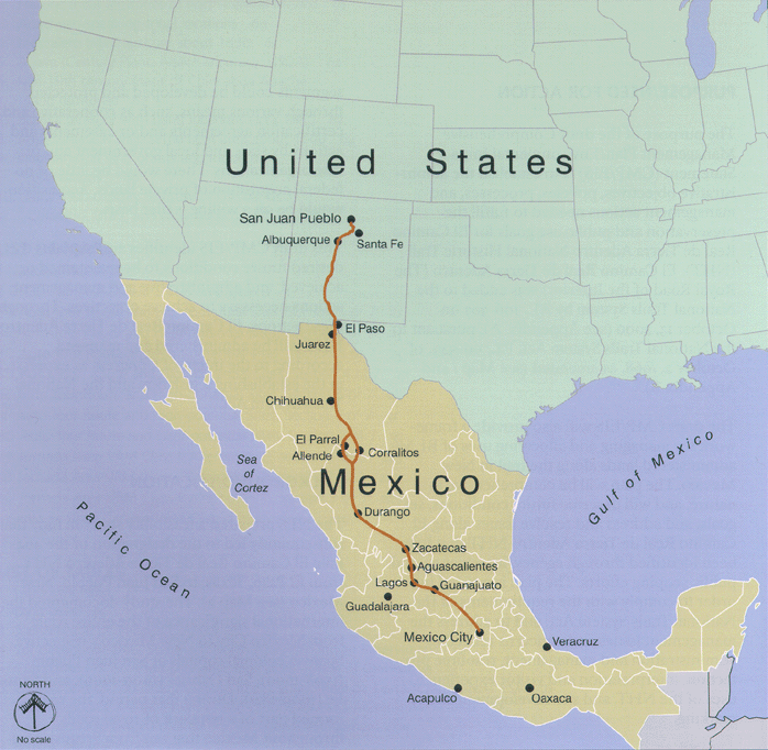
El Camino Real de Tierra Adentro
Mexico, United States · 22.6081° N, 102.3792° W · 31 km² · 27 km from Zacatecas
El Camino Real de Tierra Adentro (English: The Royal Road of the Interior Land), also known as the Silver Route, was a Spanish 2,560-kilometre-long (1,590 mi) road between Mexico City and San Juan Pueblo (Ohkay Owingeh), New Mexico (in the modern U.S.), that was used from 1598 to 1882. It was the northernmost of the four major "royal roads" that linked Mexico City to its major tributaries during and after the Spanish colonial era.
In 2010, 55 sites and five existing UNESCO World Heritage Sites along the Mexican section of the route were collectively added to the World Heritage List, including historic cities, towns, bridges, haciendas and other monuments along the 1,400-kilometre (870 mi) route between the Historic Center of Mexico City (also a World Heritage Site on its own) and the town of Valle de Allende, Chihuahua.
The 404-mile (650 km) section of the route within the United States was proclaimed the El Camino Real de Tierra Adentro National Historic Trail, a part of the National Historic Trail system, on October 13, 2000. The historic route is overseen by both the National Park Service and the U.S.
Adapted from Wikipedia: Camino Real de Tierra Adentro (CC BY-SA 4.0).
Why El Camino Real de Tierra Adentro Is Listed
- (ii)
- An important interchange of human values.
- (iv)
- An outstanding example of a type of building or landscape.
More about El Camino Real de Tierra Adentro
UNESCO's Description
Camino Real de Tierra Adentro was the Royal Inland Road, also known as the Silver Route. The inscribed property consists of 55 sites and five existing World Heritage sites lying along a 1400 km section of this 2600 km route, that extends north from Mexico City to Texas and New Mexico, United States of America. The route was actively used as a trade route for 300 years, from the mid-16th to the 19th centuries, mainly for transporting silver extracted from the mines of Zacatecas, Guanajuato and San Luis Potosí, and mercury imported from Europe. Although it is a route that was motivated and consolidated by the mining industry, it also fostered the creation of social, cultural and religious links in particular between Spanish and Amerindian cultures.
From the UNESCO World Heritage Centre (CC BY-SA IGO 3.0).
History
Long before Europeans arrived, the various indigenous tribes and kingdoms that had arisen throughout the northern central steppe of Mexico had established the route that would later become the Camino Real de Tierra Adentro as a major thoroughfare for hunting and trading. The route connected the peoples of the Valley of Mexico with those of the north through the exchange of products such as turquoise, obsidian, salt and feathers. By the year AD 1000, a flourishing trade network existed from Mesoamerica to the Rocky Mountains.
After Tenochtitlan was subdued in 1521, Spanish conquistadors and colonists began a series of expeditions with the purpose of expanding their domains and obtaining greater wealth for the Spanish Crown.
Sections adapted from Wikipedia: Camino Real de Tierra Adentro (CC BY-SA 4.0).
Key Facts
| Established | 1500 |
|---|---|
| Area | 31 km² |
Facts from Wikidata Q911953 (CC0).
Prehistoric Caves of Yagul and Mitla in the Central Valley of Oaxaca
Mexico · 16.9508° N, 96.4211° W · 15 km² · 30 km from Oaxaca
This property lies on the northern slopes of the Tlacolula valley in subtropical central Oaxaca and consists of two pre-Hispanic archaeological complexes and a series of pre-historic caves and rock shelters. Some of these shelters provide archaeological and rock-art evidence for the progress of nomadic hunter-gathers to incipient farmers. Ten thousand-year-old Cucurbitaceae seeds in one cave, Guilá Naquitz, are considered to be the earliest known evidence of domesticated plants in the continent, while corn cob fragments from the same cave are said to be the earliest documented evidence for the domestication of maize. The cultural landscape of the Prehistoric Caves of Yagul and Mitla demonstrates the link between man and nature that gave origin to the domestication of plants in North America, thus allowing the rise of Mesoamerican civilizations.
Description from the UNESCO World Heritage Centre (CC BY-SA IGO 3.0).
Why Prehistoric Caves of Yagul and Mitla in the Central Valley of Oaxaca Is Listed
- (iii)
- A unique testimony to a cultural tradition or civilisation.

El Pinacate y Gran Desierto de Altar Biosphere Reserve
Mexico · 32.0000° N, 113.9167° W · 7,146 km² · 101 km from Yuma
El Pinacate and Gran Desierto de Altar Biosphere Reserve (Spanish: Reserva de la Biosfera El Pinacate y Gran Desierto de Altar) is a biosphere reserve and UNESCO World Heritage Site managed by the federal government of Mexico, specifically by Secretariat of the Environment and Natural Resources, in collaboration with the state governments of Sonora and the Tohono O'odham.
It is in the Sonoran Desert in northwest Mexico, east of the Gulf of California, in the eastern part of the Gran Desierto de Altar, just south of the border with Arizona, United States and north of the city of Puerto Peñasco. It is one of the most significant visible landforms in North America seen from space. A volcanic system known as Santa Clara is the main part of the landscape, including three peaks: Pinacate, Carnegie and Medio. It is a sister park to Organ Pipe Cactus National Monument in Arizona. Its wildlife is threatened by the militarization of the Mexico–United States border and the construction of the Mexico–United States border wall.
In the area there are over 540 species of plants, 40 species of mammals, 200 of birds, 40 of reptiles, amphibians and freshwater fishes.
Adapted from Wikipedia: El Pinacate y Gran Desierto de Altar Biosphere Reserve (CC BY-SA 4.0).
Why El Pinacate y Gran Desierto de Altar Biosphere Reserve Is Listed
- (vii)
- Superlative natural phenomena or exceptional natural beauty.
- (viii)
- An outstanding example of major stages of the Earth's history.
- (x)
- The most important natural habitats for conserving biodiversity.
More about El Pinacate y Gran Desierto de Altar Biosphere Reserve
UNESCO's Description
The 714,566 hectare site comprises two distinct parts: the dormant volcanic Pinacate Shield of black and red lava flows and desert pavements to the east, and, in the west, the Gran Altar Desert with its ever changing and varied sand dunes that can reach a height of 200 metres. This landscape of dramatic contrast notably features linear, star and dome dunes as well as several arid granite massifs, some as high as 650 metres. The dunes emerge like islands from the sea of sand and harbour distinct and highly diverse plant and wildlife communities, including endemic freshwater fish species and the endemic Sonoran Pronghorn, which is only to be found in northwestern Sonora and in southwestern Arizona (USA). Ten enormous, deep and almost perfectly circular craters, believed to have been formed by a combination of eruptions and collapses, also contribute to the dramatic beauty of the site whose exceptional combination of features are of great scientific interest. The site is also a UNESCO Biosphere Reserve .
From the UNESCO World Heritage Centre (CC BY-SA IGO 3.0).
History
The first inhabitants are known as San Dieguito people, they were hunter-gatherer who lived off the land, moving from the mountains to the Gulf of California looking for food. The early stages of occupation seem to have ended at the beginning of the ice age about 20000 years ago, when drought forced people to leave the mountain range.
A second stage of occupation by San Dieguito people began in the late glacial period. This group returned to the mountains and lived as their ancestors had. Tinajas must have been a reliable source of water during this time. The second stage of occupation ended with the arrival of an antipyretic period 9000 years ago, which again forced the people to leave the territory.
Sections adapted from Wikipedia: El Pinacate y Gran Desierto de Altar Biosphere Reserve (CC BY-SA 4.0).
Key Facts
| Established | 28 June 2006 |
|---|---|
| Area | 7,146 km² |
Facts from Wikidata Q3821829 (CC0).

Aqueduct of Padre Tembleque
Mexico · 19.8364° N, 98.6622° W · 65 km² · 38 km from Pachuca
The Aqueduct of Padre Tembleque, or Tembleque Aqueduct, is a Mexican aqueduct located between the towns of Zempoala, Hidalgo, and Otumba in the State of Mexico.
The structure takes its name from a Spanish friar called Francisco de Tembleque.
Adapted from Wikipedia: Aqueduct of Padre Tembleque (CC BY-SA 4.0).
Why Aqueduct of Padre Tembleque Is Listed
- (i)
- A masterpiece of human creative genius.
- (ii)
- An important interchange of human values.
- (iv)
- An outstanding example of a type of building or landscape.
More about Aqueduct of Padre Tembleque
UNESCO's Description
This 16 th century aqueduct is located between the states of Mexico and Hidalgo, on the Central Mexican Plateau. This heritage canal system encompasses a water catchment area, springs, canals, distribution tanks and arcaded aqueduct bridges. The site incorporates the highest single-level arcade ever built in an aqueduct. Initiated by the Franciscan friar, Padre Tembleque, and built with support from the local indigenous communities, this hydraulic system is an example of the exchange of influences between the European tradition of Roman hydraulics and traditional Mesoamerican construction techniques, including the use of adobe.
From the UNESCO World Heritage Centre (CC BY-SA IGO 3.0).
Site description
Originally constructed between 1553 and 1570, the aqueduct stretches 45 kilometres (28 mi) long, beginning at Tecajete volcano just east of Zempoala and terminating at Otumba. It passed mostly at ground level, but also went underground as well as over ravines and valleys. There are three arcades along the aqueduct: the first has 46 arches, the second has 13, and the third has 67 arches. The highest valley the aqueduct spans is Papalote ravine, which is crossed by the 67-arch arcade also known as the Main Arcade, with the tallest arch standing 38.75 metres (127.1 ft).
Sections adapted from Wikipedia: Aqueduct of Padre Tembleque (CC BY-SA 4.0).

Revillagigedo Islands
Mexico · 18.8214° N, 112.7639° W · 6,367 km²
The Revillagigedo Islands (Spanish: Islas Revillagigedo, IPA: [reˈβiʝa xiˈxeðo]) or Revillagigedo Archipelago are a group of four volcanic islands in the Pacific Ocean, known for their unique ecosystem. They lie approximately 458 kilometres (285 mi) from Socorro Island south and southwest of Cabo San Lucas, the southern tip of the Baja California Peninsula, and 698 to 1,092 kilometres (434 to 679 mi) west of Manzanillo. Historically linked to the Mexican state of Colima, to which they were granted in 1861 to establish a penal colony, the islands are under Mexican federal property and jurisdiction.
In July 2016, the Revillagigedo Archipelago was inscribed as a UNESCO World Heritage Site, and in November 2017 they were declared to be a marine reserve and a national park of Mexico. Some of the volcanoes are active, with the last eruption of Volcán Bárcena in 1953, and Socorro in 1993. Travelling to the islands from their nearest land point takes approximately 26 to 30 hours, as they are typically reached by sea; a small military airstrip exists on Socorro.
Adapted from Wikipedia: Revillagigedo Islands (CC BY-SA 4.0).
Why Revillagigedo Islands Is Listed
- (vii)
- Superlative natural phenomena or exceptional natural beauty.
- (ix)
- An outstanding example of ongoing ecological and biological processes.
- (x)
- The most important natural habitats for conserving biodiversity.
More about Revillagigedo Islands
UNESCO's Description
Located in the eastern Pacific Ocean, this archipelago is made up of four remote islands and their surrounding waters: San Benedicto, Socorro, Roca Partida and Clarión. This archipelago is part of a submerged mountain range, with the four islands representing the peaks of volcanoes emerging above sea level. The islands provide critical habitat for a range of wildlife and are of particular importance for seabirds. The surrounding waters have a remarkable abundance of large pelagic species, such as manta rays, whales, dolphins and sharks.
From the UNESCO World Heritage Centre (CC BY-SA IGO 3.0).
Geography
The total area is 157.81 km2 (60.93 mi2), spread over an east-to-west extent of about 420 km (261 mi). A naval station in the south of Socorro Island has a population of 45 (staff). On Clarión is a small naval garrison with nine men. The islands are otherwise uninhabited. The islands are named after Don Juan Vicente de Güemes, 2nd Count of Revillagigedo, the 53rd viceroy of New Spain.
The three eastern islands are called the inner islands. They fall in the time zone UTC-7 (Mountain Time), while the major part of Colima is UTC-6 (Central Time Zone). Clarión is comparatively far to the west, by more than 200 km (100 miles) in comparison with the inner islands, and in UTC-8 (Pacific Time Zone).
Ecology
The Revillagigedo Islands are home to many endemic plant and animal species, and are sometimes called Mexico's "little Hawaii". They are recognized as a distinct terrestrial ecoregion, part of the Neotropical realm. Socorro is the most diverse in flora, fauna, and topography. The Mexican Government established the islands as a Biosphere Reserve on June 4, 1994. Oceanographic Magazine stated in 2020 that, "Its remoteness, protection and peculiar oceanography makes it one of the most biodiverse and exciting marine destinations on earth."
The islands are mostly covered with tropical dry forest, with several distinct plant communities that vary with elevation, soils, and exposure. Hopbush (Dodonaea viscosa) and Guettarda insularis are common dry forest species.
History
No evidence of human habitation on any of the islands exists before their discovery by Spanish explorers. Hernando de Grijalva and his crew discovered an uninhabited island on 19 December 1533, and named it Santo Tomás (Socorro Island) and on 28 December they discovered Isla de los Inocentes (San Benedicto) which owed its name to having been found on the day of the Holy Innocents.
In November 1542, Ruy López de Villalobos, while exploring new routes across the Pacific, rediscovered Inocentes and Santo Tomás and charted the latter as Anublada ("Cloudy"). Villalobos was the first to report sighting of Roca Partida Island giving it its present-day name. In 1608, Martín Yánez de Armida, in charge of another expedition, visited Anublada and changed its name to Socorro.
Sections adapted from Wikipedia: Revillagigedo Islands (CC BY-SA 4.0).

Huichol route to Huiricuta
Mexico · 23.9333° N, 100.7667° W · 1,354 km² · 33 km from Matehuala
The Huichol people of western Mexico exude an enduring spirit and passion to hold on to their traditions. This is exemplified in the pilgrimage route between Nayarit and Wirikuta, stretching nearly 800 km, wherein dozens of sacred sites are visited along the way. The route follows the old pre-Hispanic trade routes between the Gulf of Mexico and the Pacific Ocean. One of the most important of these routes, to Huiricuta or Wirikuta, is known as such for its historical importance in the preservation of Huichol cultural as well as the sheer proliferation of pilgrims that follow the route. Because the Huichol have no written language, the pilgrimage has the added importance of linking populations of Huichol and disseminating knowledge of culture and reinforcing cultural practices.
This site was added to the UNESCO World Heritage Tentative List on December 6, 2004 in the Mixed (Cultural + Natural) category. The site was added to the World Heritage Site list on July 12, 2025.
Adapted from Wikipedia: Huichol Route to Huiricuta (CC BY-SA 4.0).
Why Huichol route to Huiricuta Is Listed
- (iii)
- A unique testimony to a cultural tradition or civilisation.
- (vi)
- A direct association with events, ideas or beliefs of universal significance.
More about Huichol route to Huiricuta
UNESCO's Description
The Wixárika Route is a serial property of 20 sites, spanning over 500 km across five states in north-central Mexico. This “braid of trails” connects sacred landscapes central to the spiritual and cultural practices of the Wixárika Indigenous Peoples. Beginning in the Huichol Sierra, the route leads to Wirikuta in the Chihuahuan Desert, with additional sacred sites in Nayarit, Jalisco, Zacatecas, San Luis Potosi and Durango. Traversing diverse ecological regions, the route supports rituals tied to ancestral deities, agriculture, and community well-being. Known as “Tatehuarí Huajuyé” or the Path of Our Grandfather Fire, it embodies deep spiritual and environmental significance.
From the UNESCO World Heritage Centre (CC BY-SA IGO 3.0).
World Heritage in Mexico: Quick Answers
- How many UNESCO World Heritage Sites are in Mexico?
- Mexico has 32 World Heritage Sites: 26 cultural, 5 natural and 1 mixed.
- What was the first World Heritage Site in Mexico?
- Historic Centre of Mexico City and Xochimilco, inscribed in 1987. The most recent is Huichol route to Huiricuta, inscribed in 2025.
- What are the natural World Heritage Sites in Mexico?
- Sian Ka'an, Calakmul (mixed), Islands and Protected Areas of the Gulf of California, Monarch Butterfly Biosphere Reserve, El Pinacate y Gran Desierto de Altar Biosphere Reserve, Revillagigedo Islands.
- Are any World Heritage Sites in Mexico in danger?
- Yes: Islands and Protected Areas of the Gulf of California is on UNESCO's List of World Heritage in Danger.