
UNESCO World Heritage Sites in Senegal
Senegal has 6 sites on the UNESCO World Heritage List (4 cultural and 2 natural), the first inscribed in 1978 (Gorée). The map below plots every one of them alongside the rest of the List, and each site is written up in full further down the page.
- World Heritage Sites
- 6
- Cultural
- 4
- Natural and Mixed
- 2
- First Inscribed
- 1978
Map of World Heritage Sites in Senegal
CulturalNaturalMixedIn DangerLarge dots are in Senegal. Click a dot to read about the site.

Gorée
Senegal · 14.6669° N, 17.3983° W · 10 km from Dakar
Île de Gorée (French pronunciation: [ildəɡoʁe]; "Gorée Island"; Wolof: Beer Dun) is one of the 19 communes d'arrondissement (i.e. districts) of the city of Dakar, Senegal. It is an 18.2-hectare (45-acre) island located two kilometres (1.1 nmi; 1.2 mi) at sea from the main harbour of Dakar (14°40′N 17°24′W), famous as a destination for people interested in the Atlantic slave trade.
Its population as of the 2013 census was 1,680 inhabitants, giving a density of 5,802 inhabitants per square kilometre (15,030/sq mi), which is only half the average density of the city of Dakar. Gorée is both the smallest and the least populated of the 19 communes d'arrondissement of Dakar.
Other important centres for the slave trade from Senegal were further north, at Saint-Louis, Senegal, or to the south in the Gambia, at the mouths of major rivers for trade. It is a UNESCO World Heritage Site and was one of the first 12 locations in the world to be designated as such in 1978.
The name is a corruption of its original Dutch name Goeree, named after the Dutch island of Goeree. The island was also known as Palma, or Bezeguiche in Portuguese.
Adapted from Wikipedia: Gorée (CC BY-SA 4.0).
Why Gorée Is Listed
- (vi)
- A direct association with events, ideas or beliefs of universal significance.
More about Gorée
UNESCO's Description
The island of Gorée lies off the coast of Senegal, opposite Dakar. From the 15th to the 19th century, it was the largest slave-trading centre on the African coast. Ruled in succession by the Portuguese, Dutch, English and French, its architecture is characterized by the contrast between the grim slave-quarters and the elegant houses of the slave traders. Today it continues to serve as a reminder of human exploitation and as a sanctuary for reconciliation.
From the UNESCO World Heritage Centre (CC BY-SA IGO 3.0).
History and slave trade
Gorée is a small island 900 metres (3,000 ft) in length and 350 metres (1,150 ft) in width sheltered by the Cap-Vert Peninsula. Now part of the city of Dakar, it was a minor port and site of European settlement along the coast.
Being almost devoid of drinking water, the island was not settled before the arrival of Europeans, although the presence of domesticated sheep noted by Portuguese explorers indicates the island was frequented by local peoples of the nearby mainland. The island of Gorée was one of the first places in Africa to be frequented by European traders, as the Portuguese traders established themselves on the island in 1444. According to Valentim Fernandes, the Portuguese established a chapel with dry stone walls and a roof made out of straw on the island.
Sections adapted from Wikipedia: Gorée (CC BY-SA 4.0).

Djoudj National Bird Sanctuary
Senegal · 16.3585° N, 16.2741° W · 160 km² · 45 km from Saint-Louis
The Djoudj National Bird Sanctuary (French: Parc national des oiseaux du Djoudj, [d͡ʒud͡ʒ]) lies on the southeast bank of the Senegal River in Senegal, in northern Biffeche, north east of St-Louis.
It provides a variety of wetland habitats which prove very popular with migrating birds, many of which have just crossed the Sahara. Of almost 400 species of birds, the most visible are pelicans and flamingos. Less conspicuous are the aquatic warblers migrating there from Europe; for these, the park is the single most important wintering site yet discovered. A wide range of wildlife also inhabits the park, which is designated a World Heritage Site. The site was added to the list of World Heritage in Danger in 1984 due to the introduction of the invasive giant salvinia plant, which threatens to choke out the park's native vegetation. However it was removed from the list in 2006.
Adapted from Wikipedia: Djoudj National Bird Sanctuary (CC BY-SA 4.0).
Why Djoudj National Bird Sanctuary Is Listed
- (vii)
- Superlative natural phenomena or exceptional natural beauty.
- (x)
- The most important natural habitats for conserving biodiversity.
More about Djoudj National Bird Sanctuary
UNESCO's Description
Situated in the Senegal River delta, the Djoudj Sanctuary is a wetland of 16,000 ha, comprising a large lake surrounded by streams, ponds and backwaters. It forms a living but fragile sanctuary for some 1.5 million birds, such as the white pelican, the purple heron, the African spoonbill, the great egret and the cormorant.
From the UNESCO World Heritage Centre (CC BY-SA IGO 3.0).
Key Facts
| Established | 14 April 1971 |
|---|---|
| Area | 160 km² |
Facts from Wikidata Q733676 (CC0).
Niokolo-Koba National Park
Senegal · 13.0742° N, 12.7222° W · 9,130 km² · 130 km from Tambacounda
Niokolo-Koba National Park (French: Parc National du Niokolo Koba, PNNK) is a World Heritage Site and natural protected area in southeastern Senegal, near the Guinea border. It is served by Niokolo-Koba Airport, an unpaved airstrip.
Adapted from Wikipedia: Niokolo-Koba National Park (CC BY-SA 4.0).
Why Niokolo-Koba National Park Is Listed
- (x)
- The most important natural habitats for conserving biodiversity.
More about Niokolo-Koba National Park
UNESCO's Description
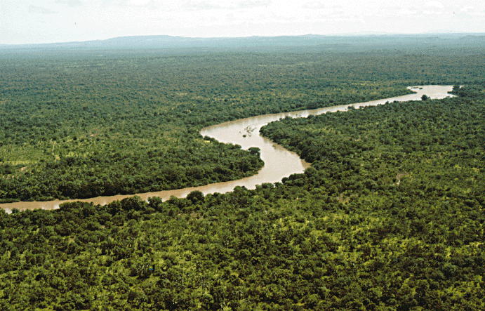
Located in a well-watered area along the banks of the Gambia river, the gallery forests and savannahs of Niokolo-Koba National Park have a very rich fauna, among them Derby elands (largest of the antelopes), chimpanzees, lions, leopards and a large population of elephants, as well as many birds, reptiles and amphibians.
From the UNESCO World Heritage Centre (CC BY-SA IGO 3.0).
Geography
Niokolo-Koba National Park lies in an upland region, through which the upper stretch of the Gambia River flows towards the northwestern border of Guinea. It covers about 9,130 km2 (3,530 sq mi) in a great arc running from upper Casamance at the Guinea-Bissau border into the Tambacounda Region, to within a 100 km (62 mi) of the Guinean border near the southeastern corner of Senegal. Its elevation ranges from 16 to 311 m (52 to 1,020 ft).
Sections adapted from Wikipedia: Niokolo-Koba National Park (CC BY-SA 4.0).
Key Facts
| Established | 1 January 1954 |
|---|---|
| Area | 9,130 km² |
Facts from Wikidata Q679891 (CC0).
Visiting Niokolo-Koba National Park
Niokolo Koba is a national park in the Tambacounda Region of in south eastern Senegal near the Guinea border. It's been inscribed on the UNESCO World Heritage List.
Travel notes adapted from Wikivoyage: Niokolo-Koba (CC BY-SA 4.0).

Island of Saint-Louis
Senegal · 16.0278° N, 16.5044° W · 1 km from Saint-Louis
The Island of Saint-Louis is the historic part of the city of Saint-Louis in Senegal. In 2000, it was inscribed by the UNESCO on the World Heritage list.
Adapted from Wikipedia: Island of Saint-Louis (CC BY-SA 4.0).
Why Island of Saint-Louis Is Listed
- (ii)
- An important interchange of human values.
- (iv)
- An outstanding example of a type of building or landscape.
More about Island of Saint-Louis
UNESCO's Description
Founded as a French colonial settlement in the 17th century, Saint-Louis was urbanised in the mid-19th century. It was the capital of Senegal from 1872 to 1957 and played an important cultural and economic role in the whole of West Africa. The location of the town on an island at the mouth of the Senegal River, its regular town plan, the system of quays, and the characteristic colonial architecture give Saint-Louis its distinctive appearance and identity.
From the UNESCO World Heritage Centre (CC BY-SA IGO 3.0).
Climate change
In 2022, the IPCC Sixth Assessment Report included the Island of Saint-Louis in the list of African cultural sites which would be threatened by flooding and coastal erosion by the end of the century, but only if climate change followed RCP 8.5, which is the scenario of high and continually increasing greenhouse gas emissions associated with the warming of over 4 °C., and is no longer considered very likely. The other, more plausible scenarios result in lower warming levels and consequently lower sea level rise: yet, sea levels would continue to increase for about 10,000 years under all of them.
History
Founded as a French colonial settlement in the 17th century, Saint-Louis was urbanised in the mid-19th century. It was the capital of Senegal from 1872 to 1957 and played an important cultural and economic role in the whole of West Africa. The location of the town on an island at the mouth of the Senegal River, its regular town plan, the system of quays, and the characteristic colonial architecture give Saint-Louis its distinctive appearance and identity.
Sections adapted from Wikipedia: Island of Saint-Louis (CC BY-SA 4.0).
Saloum Delta
Senegal · 13.8353° N, 16.4986° W · 1,458 km² · 44 km from Banjul
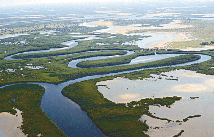
Saloum Delta or Sine-Saloum Delta is a river delta in Senegal at the mouth of the Saloum River where it flows into the North Atlantic Ocean. The delta covers 180,000 hectares. It extends 72.5 kilometers along the coastline and 35 kilometers inland.
In 2011, a 145,811-hectare portion of the delta was designated a UNESCO World Heritage Site. The site contains "brackish channels encompassing over 200 islands and islets, mangrove forest, an Atlantic marine environment, and dry forest." Saloum Delta National Park covers 76,000 hectares of the delta.
The bird species that breed or winter in the area include royal tern, greater flamingo, Eurasian spoonbill, goliath heron, curlew sandpiper, ruddy turnstone, and little stint. Aside from being a valued breeding ground for birds, the delta contains 218 shellfish mounds and artefacts unearthed at some 28 of the burial grounds have provided an important insight into the history of human occupation in the area.
In 2008, the Saloum Delta and Niumi National Park in the neighboring Gambia were declared part of the "Niumi-Saloum" Transboundary Ramsar Site.
Adapted from Wikipedia: Saloum Delta (CC BY-SA 4.0).
Why Saloum Delta Is Listed
- (iii)
- A unique testimony to a cultural tradition or civilisation.
- (iv)
- An outstanding example of a type of building or landscape.
- (v)
- An outstanding example of traditional human settlement or land use.
More about Saloum Delta
UNESCO's Description
Fishing and shellfish gathering have sustained human life in the 5,000 km2 property, which is formed by the arms of three rivers. The site comprises brackish channels encompassing over 200 islands and islets, mangrove forest, an Atlantic marine environment, and dry forest. The site is marked by 218 shellfish mounds, some of them several hundreds metres long, produced by its human inhabitants over the ages. Burial sites on 28 of the mounds take the form of tumuli where remarkable artefacts have been found. They are important for our understanding of cultures from the various periods of the delta's occupation and testify to the history of human settlement along the coast of West Africa.
From the UNESCO World Heritage Centre (CC BY-SA IGO 3.0).

Bassari Country
Senegal · 12.5933° N, 12.8458° W · 503 km²
The Bassari Country (French: Pays Bassari) and its Bassari, Fula and Bedik Cultural Landscapes (Paysages culturels Bassari, Peul et Bédik), located in the southeast of Senegal, is a well-preserved multicultural landscape which emerged from the interaction of human activities and the natural environment. It aggregates three geographical areas: the Bassari–Salémata area, the Bedik–Bandafassi area and the Fula–Dindéfello area, each one with its specific morphological characteristics.
In 2012, the Bassari Country with its Bassari, Fula and Bedik Cultural Landscapes was added to the UNESCO list of World Heritage Sites.
Adapted from Wikipedia: Bassari Country (CC BY-SA 4.0).
Why Bassari Country Is Listed
- (iii)
- A unique testimony to a cultural tradition or civilisation.
- (v)
- An outstanding example of traditional human settlement or land use.
- (vi)
- A direct association with events, ideas or beliefs of universal significance.
More about Bassari Country
UNESCO's Description
The site, located in south-east Senegal, includes three geographical areas: the Bassari–Salémata area, the Bedik–Bandafassi area and the Fula–Dindéfello area, each with its specific morphological traits. The Bassari, Fula and Bedik peoples settled from the 11th to the 19th centuries and developed specific cultures and habitats symbiotic with their surrounding natural environment. The Bassari landscape is marked by terraces and rice paddies, interspersed with villages, hamlets and archaeological sites. The Bedik villages are formed by dense groups of huts with steep thatched roofs. Their inhabitants’ cultural expressions are characterized by original traits of agro-pastoral, social, ritual and spiritual practices, which represent an original response to environmental constraints and human pressures. The site is a well-preserved multicultural landscape housing original and still vibrant local cultures.
From the UNESCO World Heritage Centre (CC BY-SA IGO 3.0).
World Heritage in Senegal: Quick Answers
- How many UNESCO World Heritage Sites are in Senegal?
- Senegal has 6 World Heritage Sites: 4 cultural and 2 natural.
- What was the first World Heritage Site in Senegal?
- Gorée, inscribed in 1978. The most recent is Bassari Country, inscribed in 2012.
- What are the natural World Heritage Sites in Senegal?
- Djoudj National Bird Sanctuary, Niokolo-Koba National Park.
- Are any World Heritage Sites in Senegal in danger?
- None of the World Heritage Sites in Senegal is on UNESCO's List of World Heritage in Danger.