
UNESCO World Heritage Sites in South Africa
South Africa has 11 sites on the UNESCO World Heritage List (7 cultural and 4 natural), the first inscribed in 1999 (Cradle of Humankind). The map below plots every one of them alongside the rest of the List, and each site is written up in full further down the page.
- World Heritage Sites
- 11
- Cultural
- 7
- Natural and Mixed
- 4
- First Inscribed
- 1999
Map of World Heritage Sites in South Africa
CulturalNaturalMixedIn DangerLarge dots are in South Africa. Click a dot to read about the site.

Cradle of Humankind
South Africa · 25.9672° S, 27.6624° E · 39 km from Brits
The Cradle of Humankind is a paleoanthropological site that is located about 50 km (31 mi) northwest of Johannesburg, South Africa, in the Gauteng province. Declared a World Heritage Site by UNESCO in 1999, the site is home to the largest known concentration of human ancestral remains anywhere in the world. The site currently occupies 47,000 hectares (120,000 acres) and contains a complex system of limestone caves. The registered name of the site in the list of World Heritage Sites is Fossil Hominid Sites of South Africa.
According to the South African Journal of Science, Bolt's Farm is the place where the earliest primates were discovered. Bolt's Farm was heavily mined for speleothem (calcium carbonate from stalagmites, stalactites, and flowstones) in the terminal nineteenth and early twentieth centuries.
The Sterkfontein Caves were the site of the discovery of a 2.3-million-year-old fossil Australopithecus africanus (nicknamed "Mrs. Ples"), found in 1947 by Robert Broom and John T. Robinson.
Adapted from Wikipedia: Cradle of Humankind (CC BY-SA 4.0).
Why Cradle of Humankind Is Listed
- (iii)
- A unique testimony to a cultural tradition or civilisation.
- (vi)
- A direct association with events, ideas or beliefs of universal significance.
More about Cradle of Humankind
UNESCO's Description
The Taung Skull Fossil Site, part of the extension to the site inscribed in 1999, is the place where in 1924 the celebrated Taung Skull – a specimen of the species Australopithecus africanus – was found. Makapan Valley, also in the site, features in its many archaeological caves traces of human occupation and evolution dating back some 3.3 million years. The area contains essential elements that define the origin and evolution of humanity. Fossils found there have enabled the identification of several specimens of early hominids, more particularly of Paranthropus, dating back between 4.5 million and 2.5 million years, as well as evidence of the domestication of fire 1.8 million to 1 million years ago.
From the UNESCO World Heritage Centre (CC BY-SA IGO 3.0).
History of discoveries
In 1935, Robert Broom found the first human fossils at Sterkfontein and began work at this site. In 1938, a young schoolboy, Gert Terrblanche, brought Raymond Dart fragments of a skull from nearby Kromdraai that later were identified as Paranthropus robustus. Also in 1938, a single human tooth was found at the Cooper's Cave site between Kromdraai and Sterkfontein.
In 1948, the Camp-Peabody Expedition from the United States worked at Bolts Farm and Gladysvale looking for fossil hominids, but failed to find any. Later in 1948, Robert Broom identified the first hominid remains from Swartkrans cave.
In 1954, C. K. Brain began working at sites in the Cradle, including Cooper's Cave.
Sections adapted from Wikipedia: Cradle of Humankind (CC BY-SA 4.0).
Visiting Cradle of Humankind
Cradle of Humankind is one of the sites in South Africa devoted to fossil hominids. This site and two others are collectively listed as a single entity by the UNESCO World Heritage Sites in South Africa .
Travel notes adapted from Wikivoyage: Cradle of Humankind (CC BY-SA 4.0).

Robben Island
South Africa · 33.8050° S, 18.3700° E · 5 km² · 14 km from Cape Town
Robben Island (Afrikaans: Robbeneiland) is an island in Table Bay, 6.9 kilometers (4.3 mi) west of the coast of Bloubergstrand, north of Cape Town, South Africa. It takes its name from the archaic Dutch word for seals (robben), hence the Dutch/Afrikaans name Robbeneiland, which translates to Seal(s) Island.
Robben Island is roughly oval in shape, 3.3 kilometres (2 miles) long north–south, and 1.9 km (1+1⁄8 mi) wide, with an area of 5.08 km2 (1+31⁄32 sq mi). It is flat and only a few metres above sea level, as a result of an ancient erosion event. It was fortified and used as a prison from the late-seventeenth century until 1996, after the end of apartheid.
During the late 20th century, it was used to imprison political prisoners who opposed the postwar apartheid state. Political activist and lawyer Nelson Mandela was imprisoned on the island for 18 of the 27 years of his imprisonment before the fall of apartheid and introduction of full, multi-racial democracy in South Africa. He was later awarded the Nobel Peace Prize and was elected in 1994 as President of South Africa, becoming the country's first black president. He served one term from 1994 to 1999.
Adapted from Wikipedia: Robben Island (CC BY-SA 4.0).
Why Robben Island Is Listed
- (iii)
- A unique testimony to a cultural tradition or civilisation.
- (vi)
- A direct association with events, ideas or beliefs of universal significance.
More about Robben Island
UNESCO's Description
Robben Island was used at various times between the 17th and 20th centuries as a prison, a hospital for socially unacceptable groups and a military base. Its buildings, particularly those of the late 20th century such as the maximum security prison for political prisoners, witness the triumph of democracy and freedom over oppression and racism.
From the UNESCO World Heritage Centre (CC BY-SA IGO 3.0).
Climate change
In 2022, the IPCC Sixth Assessment Report included Robben Island in the list of African cultural sites which would be threatened by flooding and coastal erosion by the end of the century, but only if climate change followed RCP 8.5, which is the scenario of high and continually increasing greenhouse gas emissions associated with the warming of over 4 °C., and is no longer considered very likely. The other, more plausible scenarios result in lower warming levels and consequently lower sea level rise: yet, sea levels would continue to increase for about 10,000 years under all of the scenarios.
History
Located at the entrance to Table Bay, 11 km from Cape Town, this island was 'discovered' by Bartolomeu Dias in 1488. For many years, it was used by Portuguese navigators, and later by English and Dutch sailors, as a refueling station.
In 1654, the settlers of the Dutch Cape Colony placed all of their ewes and a few rams on Robben Island. The men built a large shed and a shelter. The isolation offered better protection for the livestock against wild animals than on the mainland. The settlers also collected seal skins and boiled oil to supply the needs of the settlement.
Since the end of the 17th century, Robben Island has been used for the incarceration of chiefly political prisoners. The Dutch settlers were the first to use Robben Island as a prison.
Sections adapted from Wikipedia: Robben Island (CC BY-SA 4.0).
Visiting Robben Island
Robben Island is in the Western Cape of South Africa, approximately 7 km off the coast and 12 km from Cape Town harbour. This island is a UNESCO World Heritage Site. It was used as a prison for opponents of Apartheid, including Nelson Mandela, and is now a museum.
Travel notes adapted from Wikivoyage: Robben Island (CC BY-SA 4.0).
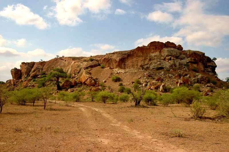
Mapungubwe Cultural Landscape
South Africa · 22.2117° S, 29.3879° E · 282 km² · 62 km from Beitbridge
Mapungubwe is set hard against the northern border of South Africa, joining Zimbabwe and Botswana. It is an open, expansive savannah landscape at the confluence of the Limpopo and Shashe rivers. Mapungubwe developed into the largest kingdom in the sub-continent before it was abandoned in the 14th century. What survives are the almost untouched remains of the palace sites and also the entire settlement area dependent upon them, as well as two earlier capital sites, the whole presenting an unrivalled picture of the development of social and political structures over some 400 years.
Description from the UNESCO World Heritage Centre (CC BY-SA IGO 3.0).
Why Mapungubwe Cultural Landscape Is Listed
- (ii)
- An important interchange of human values.
- (iii)
- A unique testimony to a cultural tradition or civilisation.
- (iv)
- An outstanding example of a type of building or landscape.
- (v)
- An outstanding example of traditional human settlement or land use.

Cape Floristic Kingdom
South Africa · 34.1667° S, 18.3750° E · 28 km from Cape Town
The Cape Floral Region is a floristic region located near the southern tip of South Africa. It is the only floristic region of the Cape Floristic Kingdom, and includes only one floristic province, known as the Cape Floristic Province.
The Cape Floristic Region, the smallest of the six recognized floral kingdoms of the world, is an area of high diversity and endemism, and is home to over 9,000 vascular plant species, of which 69 percent are endemic.
Much of this diversity is associated with the fynbos biome, a Mediterranean-type, fire-prone shrubland. The economical worth of fynbos biodiversity, based on harvests of fynbos products (e.g. wildflowers) and eco-tourism, is estimated to be in the region of R77 million (~US$5 million) a year.
Adapted from Wikipedia: Cape Floristic Region (CC BY-SA 4.0).
Why Cape Floristic Kingdom Is Listed
- (ix)
- An outstanding example of ongoing ecological and biological processes.
- (x)
- The most important natural habitats for conserving biodiversity.
More about Cape Floristic Kingdom
UNESCO's Description
Inscribed on the World Heritage List in 2004, the property is located at the south-western extremity of South Africa. It is one of the world’s great centres of terrestrial biodiversity. The extended property includes national parks, nature reserves, wilderness areas, State forests and mountain catchment areas. These elements add a significant number of endemic species associated with the Fynbos vegetation, a fine-leaved sclerophyllic shrubland adapted to both a Mediterranean climate and periodic fires, which is unique to the Cape Floral Region.
From the UNESCO World Heritage Centre (CC BY-SA IGO 3.0).
Ecology
The World Wide Fund for Nature divides the Cape floristic region into three ecoregions: the Lowland fynbos and renosterveld, Montane fynbos and renosterveld and the Albany thickets.
The fynbos ecoregions are designated one of the Global 200 priority ecoregions for conservation. Conservation International declared the Cape floristic region to be a biodiversity hotspot.
It is thought that the Cape Floristic Region is experiencing one of the most rapid rates of extinction in the world due to habitat loss, land degradation, and invasive alien plants.
Location and description
Home to the greatest non-tropical concentration of higher plant species in the world, the region is the only hotspot that encompasses an entire floral kingdom, and holds five of South Africa's 12 endemic plant families and 160 endemic genera. Covering 78,555 km2, Cape Floristic Region hotspot is located entirely within the borders of South Africa.
It is one of the five temperate Mediterranean-type systems on the hotspots list, and is one of only two hotspots that encompass an entire floral kingdom (the other being New Caledonia).
Sections adapted from Wikipedia: Cape Floristic Region (CC BY-SA 4.0).

Vredefort crater
South Africa · 26.8167° S, 27.4167° E · 300 km² · 34 km from Potchefstroom
The Vredefort impact structure is one of the largest impact structures on Earth. The crater, which has since been worn away, has been estimated at 170–300 kilometres (110–190 mi) across when it was formed, the latter estimate suggesting the initial crater was larger than Chicxulub crater, the largest mostly intact impact crater on Earth.
The remaining structure, comprising the deformed underlying bedrock, is located in present-day Free State province of South Africa. It is named after the town of Vredefort, near its centre. The structure's central uplift is known as the Vredefort Dome, which is around 100–120 kilometres (62–75 mi) in diameter. The impact structure was formed during the Paleoproterozoic Era, 2.023 billion (± 4 million) years ago. It is among the oldest known impact structures on Earth, after Yarrabubba (2.23 billion years old) and possibly Miralga.
The structure's extraterrestrial origin was established in 1961 after the location of shatter cones by American geologists Robert S. Dietz and Robert B. Hargraves, though an impact was proposed as early as 1937 by Claude C. Albritton and John D. Boon.
Adapted from Wikipedia: Vredefort impact structure (CC BY-SA 4.0).
Why Vredefort crater Is Listed
- (viii)
- An outstanding example of major stages of the Earth's history.
More about Vredefort crater
UNESCO's Description
Vredefort Dome, approximately 120 km south-west of Johannesburg, is a representative part of a larger meteorite impact structure, or astrobleme. Dating back 2,023 million years, it is the oldest astrobleme yet found on Earth. With a radius of 190 km, it is also the largest and the most deeply eroded. Vredefort Dome bears witness to the world’s greatest known single energy release event, which had devastating global effects including, according to some scientists, major evolutionary changes. It provides critical evidence of the Earth’s geological history and is crucial to understanding of the evolution of the planet. Despite the importance of impact sites to the planet’s history, geological activity on the Earth’s surface has led to the disappearance of evidence from most of them, and Vredefort is the only example to provide a full geological profile of an astrobleme below the crater floor.
From the UNESCO World Heritage Centre (CC BY-SA IGO 3.0).

Richtersveld
South Africa · 28.6000° S, 17.2039° E · 1,600 km²
The Richtersveld is a desert landscape characterised by rugged kloofs and high mountains, situated in the north-western corner of South Africa’s Northern Cape province. It is full of changing scenery from flat, sandy, coastal plains, to craggy sharp mountains of volcanic rock and the lushness of the Orange River, which forms the border with neighboring Namibia. The area ranges in altitude from sea level, to 1,377 m (4,518 ft) at Cornellberg. Located in the north-western side of the Northern Cape province in South Africa, the Richtersveld is regarded as the only arid biodiversity hotspot on earth and the majority of the area is inscribed on UNESCO's World Heritage List due to its cultural values.
The Nama people of Richtersveld claimed title to their traditional land and set aside this conservancy for future research and tourism. The northern part of the area was proclaimed in 1991 after 18 years of negotiations between the National Parks Board and the local Nama people who continue to live and graze their livestock in the area. It has an area of 1,624.45 square kilometres (627.20 sq mi).
Adapted from Wikipedia: Richtersveld (CC BY-SA 4.0).
Why Richtersveld Is Listed
- (iv)
- An outstanding example of a type of building or landscape.
- (v)
- An outstanding example of traditional human settlement or land use.
More about Richtersveld
UNESCO's Description
The 160,000 ha Richtersveld Cultural and Botanical Landscape of dramatic mountainous desert in north-western South Africa constitutes a cultural landscape communally owned and managed. This site sustains the semi-nomadic pastoral livelihood of the Nama people, reflecting seasonal patterns that may have persisted for as much as two millennia in southern Africa. It is the only area where the Nama still construct portable rush-mat houses ( haru om ) and includes seasonal migrations and grazing grounds, together with stock posts. The pastoralists collect medicinal and other plants and have a strong oral tradition associated with different places and attributes of the landscape.
From the UNESCO World Heritage Centre (CC BY-SA IGO 3.0).
Climate
The Richtersveld is characterized by harsh summer temperatures which have been recorded to reach approximately 53 °C (127 °F) in mid-summer. Nights are cool and bring with them heavy dew. With water being scarce, life in the Richtersveld depends on moisture from the early morning fog. Locals call it 'Ihuries' or 'Malmokkies' and it makes survival possible for a range of small reptiles, birds and mammals. Temperatures drop between April and May to more temperate levels, however, through June - August the nights grow much colder. Strong gale-force winds often pick up in the winter and these cause sandstorms. The wind is often cold due to the influence from the Atlantic Ocean in the west.
Sections adapted from Wikipedia: Richtersveld (CC BY-SA 4.0).

Khomani Cultural Landscape
South Africa · 25.6876° S, 20.3746° E · 9,591 km²
The ǂKhomani Cultural Landscape is located at the border with Botswana and Namibia in the northern part of the country, coinciding with the Kalahari Gemsbok National Park (KGNP). The large expanse of sand contains evidence of human occupation from the Stone Age to the present and is associated with the culture of the formerly nomadic ǂKhomani San people and the strategies that allowed them to adapt to harsh desert conditions. They developed a specific ethnobotanical knowledge, cultural practices and a worldview related to the geographical features of their environment. The ǂKhomani Cultural Landscape bears testimony to the way of life that prevailed in the region and shaped the site over thousands of years.
Description from the UNESCO World Heritage Centre (CC BY-SA IGO 3.0).
Why Khomani Cultural Landscape Is Listed
- (v)
- An outstanding example of traditional human settlement or land use.
- (vi)
- A direct association with events, ideas or beliefs of universal significance.
Makhonjwa Mountains
South Africa · 33.4000° S, 22.0000° E · 1,131 km² · 27 km from Oudtshoorn
Situated in north-eastern South Africa, the Barberton Makhonjwa Mountains comprises 40% of the Barberton Greenstone Belt, one of the world’s oldest geological structures. The property represents the best-preserved succession of volcanic and sedimentary rock dating back 3.6 to 3.25 billion years and forms a diverse repository of information on surface conditions, meteorite impacts, volcanism, continent-building processes and the environment of early life.
Description from the UNESCO World Heritage Centre (CC BY-SA IGO 3.0).
Why Makhonjwa Mountains Is Listed
- (viii)
- An outstanding example of major stages of the Earth's history.

Human Rights, Liberation and Reconciliation: Nelson Mandela Legacy Sites
South Africa · 33.9439° S, 18.5272° E · 9 km from Cape Town
The serial property represents the legacy of the South African struggle for human rights, liberation and reconciliation. It consists of fourteen component parts located around the country, all related to South Africa’s political history in the 20th century. The parts include the Union Buildings (Pretoria), now the official seat of government; the Sharpeville Sites, commemorating the massacre of 69 people protesting the unjust Pass Laws; and The Great Place at Mqhekezweni, a site symbolic of traditional leadership where Nelson Mandela lived as a young man. These places reflect key events linked to the long struggle against the apartheid state; Mandela’s influence in promoting understanding and forgiveness; and belief systems based on philosophies of non-racialism, Pan-Africanism and ubuntu, a concept that implies humanity is not solely embedded in an individual.
Description from the UNESCO World Heritage Centre (CC BY-SA IGO 3.0).
Why Human Rights, Liberation and Reconciliation: Nelson Mandela Legacy Sites Is Listed
- (vi)
- A direct association with events, ideas or beliefs of universal significance.

The Emergence of Modern Humans: The Pleistocene occupation sites of South Africa
South Africa · 32.3864° S, 18.4525° E · 1 km² · 85 km from Saldanha
This serial property contributes to the understanding of the origin of behaviourally modern humans, their cognitive abilities and cultures, and the climatic transitions that they survived. It is composed of three dispersed archaeological sites, Diepkloof Rock Shelter, Pinnacle Point Site Complex, and Sibhudu Cave, located in the Western Cape and KwaZulu-Natal provinces of South Africa. These sites provide the most varied and best-preserved record known of the development of modern human behaviour, reaching back as far as 162,000 years. Symbolic thought and advanced technologies are exemplified by evidence of ochre processing, engraved patterns, decorative beads, decorated eggshells, advanced projectile weapons and techniques for toolmaking, and microliths.
Description from the UNESCO World Heritage Centre (CC BY-SA IGO 3.0).
Why The Emergence of Modern Humans: The Pleistocene occupation sites of South Africa Is Listed
- (iii)
- A unique testimony to a cultural tradition or civilisation.
- (iv)
- An outstanding example of a type of building or landscape.
- (v)
- An outstanding example of traditional human settlement or land use.
Shared With Neighbouring Countries
These sites cross the border. Each is written up on the page of the country UNESCO lists first.

World Heritage in South Africa: Quick Answers
- How many UNESCO World Heritage Sites are in South Africa?
- South Africa has 11 World Heritage Sites: 7 cultural and 4 natural. 1 of them is shared with a neighbouring country.
- What was the first World Heritage Site in South Africa?
- Cradle of Humankind, inscribed in 1999. The most recent is Human Rights, Liberation and Reconciliation: Nelson Mandela Legacy Sites, inscribed in 2024.
- What are the natural World Heritage Sites in South Africa?
- iSimangaliso Wetland Park, Cape Floristic Kingdom, Vredefort crater, Makhonjwa Mountains.
- Are any World Heritage Sites in South Africa in danger?
- None of the World Heritage Sites in South Africa is on UNESCO's List of World Heritage in Danger.