
Map of Comoros
Comoros is a country in Africa with its capital at Moroni, home to about 882,847 people across 2,034 km². The interactive map below plots 1 cities and towns, 1 mountain summits and 3 ports recorded for Comoros in YearMaps.
- Population
- 882,847
- Area
- 2,034 km²
- Capital
- Moroni
- Continent
- Africa
Interactive Map of Comoros
Centred on Moroni at 11.7042° S, 43.2402° E. Use the layer panel to switch on rivers, dams, ports, peaks and historical borders.
About Comoros
The Comoros, officially the Union of the Comoros, is an archipelagic country made up of three islands in Southeast Africa, located at the northern end of the Mozambique Channel in the Indian Ocean. Its capital and largest city is Moroni. The predominant religion of the population—and the official state religion—is Islam. Comoros proclaimed its independence from France on 6 July 1975. The country has three official languages: Comorian, French and Arabic. The Comoros is the only country of the Arab League which is entirely in the Southern Hemisphere. It is also a member state of the African Union, the Organisation internationale de la Francophonie, the Organisation of Islamic Cooperation, and the Indian Ocean Commission.
At 1,659 square kilometres (641 sq mi), the Comoros is the third-smallest African country by area after São Tomé and Príncipe and Seychelles. Although its population was estimated in 2026 to only number 944,388, the Comoros ranks as one of the most densely populated countries in the world. The sovereign state consists of three major islands, namely Grande Comore, Anjouan, and Mohéli, and numerous smaller islands, all of the volcanic Comoro Islands with the exception of Mayotte. Mayotte voted against independence from France in a referendum in 1974 and continues to be administered by France as an overseas department. France has repeatedly vetoed United Nations Security Council resolutions that would have affirmed Comorian sovereignty over the island. Mayotte became the overseas department and a region of France in 2011 following a referendum which was passed overwhelmingly. However, the Comoros continues to claim the island, with backing from the AU and UN.
The Comoros were likely first settled by Austronesian-speaking Malagasy peoples, Bantu speakers from East Africa, and seafaring Arab traders. From 1500 the Sultanate of Anjouan dominated the islands, with Grande Comore split between several sultans. It became part of the French colonial empire during the 19th century, before its independence in 1975. It has experienced more than 20 coups or attempted coups, with various heads of state assassinated. Along with this political instability, it ranks in the medium quartile on the Human Development Index. In 2023, the Comoros had the least income inequality among its peers regionally, though poverty remains widespread especially in rural areas. Between 2009 and 2014, about 19% of the population lived below the international poverty line of US $1.90 a day by purchasing power parity.
Summary adapted from Wikipedia: Comoros (CC BY-SA 4.0).

Geography and Climate of Comoros
For centuries prior to colonization in the 19th century, the Comoros archipelago in the Indian Ocean served as a key node in maritime trade networks that connected the Middle East, India, and eastern African regions. Composed of the islands of Anjouan, Mayotte, Moheli, and Grande Comore, Comoros spent most of the 20th century as a colonial outpost until it declared independence from France on 6 July 1975. Residents of Mayotte, however, voted to remain in France, and the French Government has since classified it as a French Overseas Department. Since independence, Comoros has weathered approximately 20 successful and attempted coups, mostly between 1975 and 2000, resulting in prolonged political instability and stunted economic development. In 2002, President AZALI Assoumani became the first elected president following the completion of the Fomboni Accords, in which the islands of Grande Comore, Anjouan, and Moheli agreed to rotate the presidency among the islands every five years. This power-sharing agreement also included provisions allowing each island to maintain its local government. In 2007, Mohamed BACAR effected Anjouan's de-facto secession from the Union of the Comoros, refusing to step down when Comoros' other islands held legitimate elections. The African Union (AU) initially attempted to resolve the political crisis with sanctions and a naval blockade of Anjouan, but in 2008, the AU and Comoran soldiers seized the island. The island's inhabitants generally welcomed the move. In 2011, Ikililou DHOININE won the presidency in peaceful elections widely deemed to be free and fair. In closely contested elections in 2016, AZALI won a second term, when the rotating presidency returned to Grande Comore. In 2018, a referendum -- which the opposition parties boycotted -- approved a new constitution that extended presidential term limits and abolished the requirement for the presidency to rotate between the three main islands. AZALI formed a new government later that year, and he subsequently ran and was reelected in 2019. AZALI was reelected again in January 2024 in an election that the opposition disputed but the Supreme Court validated.
- Location
- Southern Africa, group of islands at the northern mouth of the Mozambique Channel, about two-thirds of the way between northern Madagascar and northern Mozambique.
- Climate
- Tropical marine; rainy season (November to May)
- Terrain
- Volcanic islands, interiors vary from steep mountains to low hills.
- Highest point
- Karthala 2,360 m.
- Lowest point
- Indian Ocean 0 m.
- Coastline
- 340 km.
- Land borders
- Total: 0 km.
- Natural resources
- Fish.
- Land use
- Agricultural land: 71.5% (2023 est.); arable land: 34.9% (2023 est.); permanent crops: 28.5% (2023 est.); permanent pasture: 8.1% (2023 est.); forest: 17.8% (2023 est.); other: 10.7% (2023 est.)
- Natural hazards
- Cyclones possible during rainy season (December to April); volcanic activity on Grand Comore volcanism: Karthala (2,361 m) on Grand Comore Island last erupted in 2007; a 2005 eruption forced thousands of people to be evacuated and produced a large ash cloud.
- Geographic note
- Important location at northern end of Mozambique Channel; the only Arab League country that lies entirely in the Southern Hemisphere.
- Languages
- Arabic (official), French (official), Shikomoro (official; similar to Swahili), Comorian.
- Religions
- Muslim 98.1% (overwhelmingly Sunni Muslim, small Shia Muslim and Ahmadiyya Muslim populations), ethnic religionist 1.1%, Christian 0.6%, other 0.3% (2020 est.)
- Ethnic groups
- Antalote, Cafre, Makoa, Oimatsaha, Sakalava.
- Economy
- Small trade-based island economy; declining remittances; new structural and fiscal reforms; adverse cyclone and COVID-19 impacts; manageable debts; fragile liquidity environment; large foreign direct investment; state-owned enterprises suffering.
From the CIA World Factbook (public domain), archived edition of 2026-01-22. The Factbook is no longer updated, so figures reflect that edition.
Comoros in Numbers
- Population
- 882,847
- GDP
- US$1.8 billion
- GDP per person
- US$2,056
- Life expectancy
- 67.0 years
- Population growth
- 1.85% a year
- Population density
- 464 per km²
- Urban population
- 33.9%
- Surface area
- 1,870 km²
- Forest cover
- 17.8%
- Arable land
- 29.6%
- Access to electricity
- 91.7%
- Internet users
- 32.5%
Indicators from World Bank Open Data (CC BY 4.0). The year under each figure is its reference year.
Comoros in Depth
History
According to mythology, a jinni dropped a jewel, which formed a great circular inferno. This became the Karthala volcano, which created the island of Ngazidja (Grande Comore). King Solomon is also said to have visited the island accompanied by his queen Bilqis.
The first attested human inhabitants of the Comoro Islands are now thought to have been Austronesian settlers travelling by boat from islands in Southeast Asia. These people arrived in the area no later than the eighth century AD, the date of the earliest known archaeological site, found on Mayotte, although settlement beginning in the first century has been postulated.
Subsequent settlers came from the east coast of Africa, the Arabian Peninsula and the Persian Gulf, the Malay Archipelago, and Madagascar.
Geography
The Comoros is formed by Ngazidja (Grande Comore), Mwali (Mohéli) and Ndzwani (Anjouan), three major islands in the Comoros Archipelago, as well as many minor islets. The islands are officially known by their Comorian-language names, though international sources still use their French names (given in parentheses above). The capital and largest city, Moroni, is located on Ngazidja and the most densely populated city is Anjouan. The archipelago is situated in the Indian Ocean, in the Mozambique Channel, between the African coast (nearest to Mozambique and Tanzania) and Madagascar, with no land borders.
At 1,659 km2 (641 sq mi), it is one of the smallest countries in the world. The Comoros also has a claim to 320 km2 (120 sq mi) of territorial seas.
Economy
The level of poverty in the Comoros is high, but "judging by the international poverty threshold of $1.9 per person per day, only two out of every ten Comorians could be classified as poor, a rate that places the Comoros ahead of other low-income countries and 30 percentage points ahead of other countries in Sub-Saharan Africa." Poverty declined by about 10% between 2014 and 2018, and living conditions generally improved. Economic inequality was historically higher in the country relative to other lower-middle income African countries, though it has declined significantly in recent years. There is a major gap between urban and rural areas, with nearly 80% of the poor living in the latter.
Demographics
With about 940,000 residents, the Comoros is one of the least populous countries in the world, but its population density is high, with an average of 457 inhabitants per square kilometre (1,180/sq mi). In 2001, 34% of the population was considered urban, but the urban population has since grown; in recent years rural population growth has been negative, while overall population growth is still relatively high. In 1958 the population was 183,133.
In 2009, almost half the population of the Comoros was under the age of 15.
Sections adapted from Wikipedia: Comoros (CC BY-SA 4.0).
Comoros: Key Facts
| Currency | Comorian franc |
|---|---|
| Official languages | Comorian, Arabic, French |
| Head of state | Azali Assoumani |
| Head of government | Azali Assoumani |
| Form of government | federal republic |
| Calling code | +269 |
| Internet domain | .km |
| Highest point | Mount Karthala |
| Lowest point | Indian Ocean |
| Established | 6 July 1975 |
Facts from Wikidata Q970 (CC0).
History of Comoros: Empires and States
The atlas records 11 polities whose mapped territory included part of Comoros, from Kingdom of France in 1677 CE to 2024 CE. They are listed in the order they first appear.
| Polity | Period here | Extent |
|---|---|---|
| Kingdom of France | 1677–1790 CE | Nearly all |
| French India | 1677–1845 CE | Nearly all |
| First French Empire | 1805–1814 CE | Nearly all |
| The French Colonial Empire | 1805–1957 CE | Nearly all |
| Bourbon Kingdom of France | 1842–1848 CE | Nearly all |
| French Africa | 1846–1957 CE | Nearly all |
| Second French Empire | 1853–1870 CE | Nearly all |
| French Third Republic | 1871–1939 CE | Nearly all |
| French Fourth Republic | 1945–1957 CE | Nearly all |
| French Fifth Republic | 1958–2023 CE | Nearly all |
| Republic of Cabo Verde | 1976–2024 CE | Nearly all |
Historical Maps of Comoros
Comoros on the world map in each year one of these states held it:
Derived by testing mapped cities against dated territorial polygons. Dates are when the polygons cover this place, not the polity's whole lifespan, and polities absent from the source dataset are not listed.
Visiting Comoros
The Comoros (French: Comores; Arabic: جزر القمر Juzur al-Qumur) is an island nation off the coast of East Africa, in the Indian Ocean between northern Mozambique and northern Madagascar.
Travel notes adapted from Wikivoyage: Comoros (CC BY-SA 4.0).
Largest Cities in Comoros
1 city recorded. Ranked by metropolitan population. A port city's harbour is written up on the page of its sea.
| # | Name | Population | Region | Role |
|---|---|---|---|---|
| 1 | Moroni | 128,698 | — | National capital |
Highest Mountains in Comoros
1 mountain recorded. Ranked by summit elevation above sea level. A summit on a border is listed under both countries.
| # | Name | Elevation | Feet | Region |
|---|---|---|---|---|
| 1 | Kartala | 2,361 m | 7,746 ft | Africa |
Ports in Comoros
3 ports recorded. Ranked by approach channel depth, the figure that limits which ships can call. Harbours link to their write-up on the page of the sea or coast they lie on.
| # | Name | Channel Depth | Class | Sea | Max Vessel |
|---|---|---|---|---|---|
| 1 | Moutsamoudu | 38.4 m | Very Small | East & Southern Africa | medium vessels |
| 2 | Fomboni | 5.5 m | Very Small | East & Southern Africa | medium vessels |
| 3 | Moroni | 5.5 m | Very Small | East & Southern Africa | medium vessels |
UNESCO World Heritage Sites in Comoros
1 World Heritage Site recorded. Listed by year of inscription, earliest first. Sites shared with another country appear under each.
| # | Name | Inscribed | Type | Criteria |
|---|---|---|---|---|
| 1 | The Medinas of the Historic Sultanates of the Comoros | 2026 | Cultural | (iii) (iv) |
Largest Islands of Comoros
3 islands recorded. Ranked by mapped area. An island divided between countries is listed under each, with the area of the whole island.
| # | Name | Area | Type |
|---|---|---|---|
| 1 | Grande Comore | 1,029 km² | Island |
| 2 | Anjouan | 450 km² | Island |
| 3 | Mohéli | 200 km² | Island |

Grande Comore
Island · 1,029 km²
Grande Comore is an island in Africa (Comores), covering an estimated 1,029 km².
Ngazidja, known as Grande Comore (French pronunciation: [ɡʁɑ̃d kɔmɔʁ];) in French, and formerly known in English as Comoro, is an island in Comoros off the coast of Africa. It is the largest island in the Comoros nation. Most of its population is of the Comorian ethnic group. Its population as of 2006 is about 316,600. The island's capital is Moroni, which is also the national capital. The island is made up of two shield volcanoes, with Mount Karthala being the country's highest point at 2,361 m (7,746 ft) above sea level. In line with the 2009 revision of the constitution of 2002, it is governed by an elected governor, as are the other islands, with the federal government being much reduced in power.
Adapted from Wikipedia: Grande Comore (CC BY-SA 4.0).
- Feature class
- Island
- Mapped extent
- 1,029 km²
- Size rank
- #293 of 445 islands
- Region
- Africa
- Subregion
- Comores
- Coordinates
- -11.7526°, 43.3439°
- Summits:
- Benara (660 m), Maromokotro (2,876 m), Mount Kilimanjaro (5,895 m)
- Ranges:
- Inyanga Mountains (Africa), Lebombo Mountains (Africa)
More about Grande Comore
History
For several centuries, Ngazidja was divided into a number of sultanates, including Bambao, Itsandra, Mitsamihuli, Mbadjini, Hambuu, Washili, Hamahame, Mbwankuu, Mbude and Domba. The sultans were also known as mfaume. In 1886, the ruler of Anjouan, Sultan Said Ali bin Said Omar declared a "state of Ngazidja", usurping the other sultanates and accepting a French protectorate over the island. In 1893, Sultan Said Ali was sent into exile on Réunion. In 1910 he abdicated and in 1912 France annexed the island and the sultanate was abolished. In 1975, Ngazidja, Anjouan and Mohéli declared independence as the nation of Comoros.
On 23 November 1996, Ethiopian Airlines Flight 961 was hijacked while in Ethiopian airspace en route from Addis Ababa to Nairobi.
Sections adapted from Wikipedia: Grande Comore (CC BY-SA 4.0).
Grande Comore: Key Facts
| Area | 1,017 km² |
|---|---|
| Population | 379,367 (2017) |
| Highest point | Mount Karthala |
| Surrounded by | Mozambique Channel |
Facts from Wikidata Q244978 (CC0).

Anjouan
Island · 450 km²
Anjouan is an island in Africa (Indian Ocean), covering an estimated 450 km².
Anjouan ([ɑ̃.ʒu.ɑ̃]) is an autonomous volcanic island in the Comoro Islands in the southwestern Indian Ocean, part of the Union of the Comoros. It is known in Shikomori as Ndzuani, Ndzuwani or Nzwani, and, until the early twentieth century when the name fell out of general use (although still sometimes used by English-speakers in Zanzibar), in English as Johanna. Historically it was also called Hinzuan or Hanzoan.
Its chief town is Mutsamudu and, as of 2006, its population is around 277,500. The total area of the island is 424 square kilometres (163 square miles).
Adapted from Wikipedia: Anjouan (CC BY-SA 4.0).
- Feature class
- Island
- Mapped extent
- 450 km²
- Size rank
- #340 of 445 islands
- Region
- Africa
- Subregion
- Indian Ocean
- Coordinates
- -12.2112°, 44.4469°
- Summits:
- Benara (660 m), Maromokotro (2,876 m), Mount Kilimanjaro (5,895 m)
- Ranges:
- Inyanga Mountains (Africa), Lebombo Mountains (Africa)
More about Anjouan
Geography
Anjouan is part of the Comoros Islands located in the Mozambique Channel. It consists of the eroded remains of a large shield volcano that formed in the Pleistocene epoch. Eruptions from fissure vents spanned in three directions, followed by a long interval of erosion. Renewed volcanism produced a series of lava flows that filled deep valleys and flooded areas along the coast. The island is known for its steep, mountainous terrain and black sand beaches. Mount Ntringui is the highest point in the island of Anjouan with an elevation of 1,595 m (5,233 ft) above sea level. The second most important (and the most populous) city on Anjouan is Domoni.
History
The first inhabitants of the island were Bantu-speaking peoples from eastern Africa and navigators from Indonesia and Southwest Asia. In the late fifteenth century high status Hadrami Arab immigrants married into the local ruling classes and established a sultanate that extended its control over the entire island and occasionally extending their influence to the neighboring island of Mwali and Mayotte. In 1812, Sultan Alawi bin Husain requested British assistance against Malagasy slavers who were threatening his domain, which was turned down. Nevertheless, the island remained within the British sphere of influence until the late 19th century.
Economy
The island uses the Comorian franc as a currency which is printed by the Bank of France and issued by the Central Bank of the Comoros. Many people on the island farm ylang-ylang, vanilla, and cloves. The economy of the island is dependent on agriculture and related industries. These industries employ over 80% of the workforce. The island's main food staple is rice, all of which is imported. Anjouan is the world's primary exporter of ylang-ylang oil, an ingredient in almost all perfumes.
As part of the Union of the Comoros, the banking system of Anjouan is regulated by the Central Bank of the Comoros, created in 1981. Anjouan, pursuant to the Regulation of Banks and Comparable Establishments of 1999, licensed more than 300 offshore banks.
Sections adapted from Wikipedia: Anjouan (CC BY-SA 4.0).
Anjouan: Key Facts
| Area | 424 km² |
|---|---|
| Population | 240,000 |
| Surrounded by | Mozambique Channel |
Facts from Wikidata Q231324 (CC0).
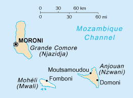
Mohéli
Island · 200 km²
Mohéli is an island in Africa (Comores), covering an estimated 200 km².
Mohéli [mɔ.e.li], also known as Mwali, is an autonomously-governed island that forms part of the Union of the Comoros. It is the smallest of the three major islands in the country. It is located in the Indian Ocean off the coast of Africa and it is the smallest of the four major Comoro Islands. Its capital and largest city is Fomboni.
Adapted from Wikipedia: Mohéli (CC BY-SA 4.0).
- Feature class
- Island
- Mapped extent
- 200 km²
- Size rank
- #368 of 445 islands
- Region
- Africa
- Subregion
- Comores
- Coordinates
- -12.3088°, 43.7082°
- Summits:
- Benara (660 m), Maromokotro (2,876 m), Mount Kilimanjaro (5,895 m)
- Ranges:
- Inyanga Mountains (Africa), Lebombo Mountains (Africa)
More about Mohéli
History
Until 1830, Mohéli was part of the Ndzuwani Sultanate, which also controlled the neighbouring island of Anjouan. In 1830, migrants from Madagascar led by Ramanetaka, who later changed his name to Abderemane, took over the island and established the sultanate of Mwali. Its ruler was Queen Jumbe-Souli in the mid-nineteenth century. In 1886, France made the island a protectorate.
Until 1889, Mwali had its own French resident, but the island was then subjugated to the residency of Anjouan. The sultanate was dismantled in 1909 following the French annexation of the island. French colonial stamps bearing the inscription "Mohéli" were circulated between 1906 and 1912.
In 1975, Mohéli agreed to join the Comoros nation, along with Grande Comore and Anjouan.
Sections adapted from Wikipedia: Mohéli (CC BY-SA 4.0).
Mohéli: Key Facts
| Area | 290 km² |
|---|---|
| Population | 40,000 |
| Surrounded by | Mozambique Channel |
Facts from Wikidata Q271797 (CC0).
Countries Bordering Comoros
Land and maritime neighbours.
More Maps in Africa
Comoros: Quick Answers
- What is the capital of Comoros?
- The capital of Comoros is Moroni.
- What is the population of Comoros?
- Comoros has a population of about 882,847, the #163 largest of 225 countries in YearMaps. Source: World Bank, 2025.
- How big is Comoros?
- Comoros covers 2,034 km², ranking #183 by area, with about 434 people per square kilometre.
- Which continent is Comoros in?
- Comoros is in Africa.
- Which countries border Comoros?
- Comoros shares a land or maritime border with France, Tanzania, Madagascar, Mozambique, Seychelles.
- What is the largest city in Comoros?
- Moroni is the largest city in Comoros, with a metropolitan population of about 128,698.
- What is the highest mountain in Comoros?
- The highest summit recorded for Comoros in YearMaps is Kartala at 2,361 m (7,746 ft). Summits on a border are counted for both countries.