
Map of Rwanda
Rwanda is a country in Africa with its capital at Kigali, home to about 14.57 million people across 26,338 km². The interactive map below plots 11 cities and towns, 1 rivers, 1 lakes and 1 mountain summits recorded for Rwanda in YearMaps.
- Population
- 14.57 million
- Area
- 26,338 km²
- Capital
- Kigali
- Continent
- Africa
Interactive Map of Rwanda
Centred on Kigali at 1.9516° S, 30.0586° E. Use the layer panel to switch on rivers, dams, ports, peaks and historical borders.
About Rwanda
Rwanda, officially the Republic of Rwanda, is a landlocked country in East Africa. Its geography is dominated by mountains in the west and savanna in the southeast. The largest and most notable lakes are mainly in the western and northern regions of the country, and several volcanoes that form part of the Virunga volcanic chain are primarily in the northwest. The climate is considered tropical highland, with two rainy seasons and two dry seasons each year. Its capital and largest city is Kigali, located at the centre of the country, at 1,567 metres above sea level. Rwanda lies a few degrees south of the Equator in the Great Rift Valley of East Africa. Rwanda is bordered by Uganda to the north, Tanzania to the east, Burundi to the south, and the Democratic Republic of the Congo to the west. With a population of about 14 million people living within a total area of 26,338 square kilometres (10,169 sq mi), of which land accounts for about 93.7%, Rwanda is the 21st most densely populated country in the world, with an average of about 578 people per square kilometre (1,500 per square mile).
Hunter-gatherers settled the territory in the Stone and Iron Ages, followed later by Bantu peoples. The population coalesced first into clans, and then into kingdoms. In the 15th century, one kingdom, under King Gihanga, managed to incorporate several of its close neighbour territories establishing the Kingdom of Rwanda. The Kingdom of Rwanda dominated from the mid-eighteenth century, with its Tutsi kings conquering others militarily, centralising power, and enacting unifying policies. In 1897, Germany colonized Rwanda as part of German East Africa, followed by Belgium, which took control in 1916 during World War I. Both European nations ruled through the Rwandan king and perpetuated a pro-Tutsi policy. The Hutu population revolted in 1959. They massacred numerous Tutsi and ultimately established an independent, Hutu-dominated republic in 1962 led by President Grégoire Kayibanda. A 1973 military coup overthrew Kayibanda and brought Juvénal Habyarimana to power, who retained the pro-Hutu policy. The Tutsi-led Rwandan Patriotic Front (RPF) launched a civil war in 1990. Habyarimana was assassinated in April 1994 by unknown parties. Social tensions erupted in the Rwandan genocide carried out by Hutu Power extremists against the Tutsis. The RPF ended the genocide with a military victory in July 1994.
Rwanda has been governed by the RPF as a de facto one-party state since 1994 with former commander Paul Kagame serving as president since 2000.
Summary adapted from Wikipedia: Rwanda (CC BY-SA 4.0).

Geography and Climate of Rwanda
Rwanda -- a small and centralized country dominated by rugged hills and fertile volcanic soil -- has exerted disproportionate influence over the African Great Lakes region for centuries. A Rwandan kingdom increasingly dominated the region from the mid-18th century onward, with the Tutsi monarchs gradually extending the power of the royal court into peripheral areas and expanding their borders through military conquest. While the current ethnic labels Hutu and Tutsi predate colonial rule, their flexibility and importance have varied significantly over time and often manifested more as a hierarchical class distinction than an ethnic or cultural distinction. The majority Hutu and minority Tutsi have long shared a common language and culture, and intermarriage was frequent. The Rwandan royal court centered on the Tutsi king (mwami), who relied on an extensive network of political, cultural, and economic relationships. Social categories became more rigid during the reign of RWABUGIRI (1860-1895), who focused on aggressive expansion and solidifying Rwanda’s bureaucratic structures. German colonial conquest began in the late 1890s, but the territory was ceded to Belgian forces in 1916 during World War I. Both European nations quickly realized the benefits of ruling through the already centralized Rwandan Tutsi kingdom. Colonial rule reinforced existing trends toward autocratic and exclusionary rule, leading to the elimination of traditional positions of authority for Hutus. Belgian administrators significantly increased requirements for communal labor and instituted harsh taxes, which fed the population's frustration. Changing political attitudes in Belgium contributed to colonial and Catholic officials shifting their support from Tutsi to Hutu leaders in the years leading up to independence. Simmering resentment of minority rule exploded in 1959, three years before independence from Belgium, when Hutus overthrew the Tutsi king. Thousands of Tutsis were killed over the next several years, and some 150,000 were driven into exile in neighboring countries. Army Chief of Staff Juvenal HABYARIMANA seized power in a coup in 1973 and ruled Rwanda as a single-party state for two decades. HABYARIMANA increasingly discriminated against Tutsis, and extremist Hutu factions gained prominence after multiple parties were introduced in the early 1990s. The children of Tutsi exiles later formed a rebel group, the Rwandan Patriotic Front (RPF) and began a civil war in 1990. The civil war exacerbated ethnic tensions and culminated in the shooting down of HABYARIMANA’s private jet in 1994. The event sparked a state-orchestrated genocide in which Rwandans killed more than 800,000 of their fellow citizens, including approximately three-quarters of the Tutsi population. The genocide ended later the same year when the predominantly Tutsi RPF, operating out of Uganda and northern Rwanda, defeated the national army and Hutu militias and established an RPF-led government of national unity. Rwanda held its first local elections in 1999 and its first post-genocide presidential and legislative elections in 2003, formalizing President Paul KAGAME’s de facto role as head of government. KAGAME was formally elected in 2010, and again in 2017 after changing the constitution to allow him to run for a third term.
- Location
- Central Africa, east of the Democratic Republic of the Congo, north of Burundi.
- Climate
- Temperate; two rainy seasons (February to April, November to January); mild in mountains with frost and snow possible.
- Terrain
- Mostly grassy uplands and hills; relief is mountainous with altitude declining from west to east.
- Highest point
- Volcan Karisimbi 4,519 m.
- Lowest point
- Rusizi River 950 m.
- Coastline
- 0 km (landlocked)
- Land borders
- Total: 930 km; border countries: Burundi 315 km; Democratic Republic of the Congo 221 km; Tanzania 222 km; Uganda 172 km.
- Major rivers
- Nile river source (shared with Tanzania, Uganda, South Sudan, Sudan, and Egypt [m]) - 6,650 km note: [s] after country name indicates river source; [m] after country name indicates river mouth.
- Major lakes
- Fresh water lake(s): Lake Kivu (shared with Democratic Republic of Congo) - 2,220 sq km.
- Natural resources
- Gold, cassiterite (tin ore), wolframite (tungsten ore), methane, hydropower, arable land.
- Land use
- Agricultural land: 76.3% (2023 est.); arable land: 47% (2023 est.); permanent crops: 13.7% (2023 est.); permanent pasture: 15.6% (2023 est.); forest: 24.5% (2023 est.); other: 0% (2023 est.)
- Natural hazards
- Periodic droughts; the volcanic Virunga Mountains are in the northwest along the border with Democratic Republic of the Congo volcanism: Visoke (3,711 m), on the border with the Democratic Republic of the Congo, is the country's only historically active volcano.
- Geographic note
- Landlocked; most of the country is intensively cultivated and rugged, with the population predominantly rural.
- Languages
- Kinyarwanda (official, universal Bantu vernacular) 93.2%, French (official) <0.1%, English (official) <0.1%, Swahili/Kiswahili (official, used in commercial centers) <0.1%, more than one language, other 6.3%, unspecified 0.3% (2002 est.)
- Religions
- Catholic 39.9%, Pentecostal 21.3%, Protestant 14.6%, Adventist 12.2%, other Christians 4.2%, no religion 3.0%, Muslim 2.0%, other religions 2.0%; less than 1%: Jehovah Witness, not specified, Animist (2022 est.)
- Ethnic groups
- Hutu, Tutsi, Twa.
- Economy
- Low-income Sub-Saharan economy; services, industry, and agriculture sectors driving growth; increased government spending on human capital, energy, and healthcare; major infrastructure projects including the Bugesera Airport intended to support long-term growth; challenges include lack of economic diversification, high inflation, and wide current account deficit.
From the CIA World Factbook (public domain), archived edition of 2026-01-22. The Factbook is no longer updated, so figures reflect that edition.
Rwanda in Numbers
- Population
- 14.57 million
- GDP
- US$16.4 billion
- GDP per person
- US$1,124
- Life expectancy
- 68.0 years
- Population growth
- 2.17% a year
- Population density
- 600 per km²
- Urban population
- 30.9%
- Surface area
- 26,340 km²
- Forest cover
- 26.1%
- Arable land
- 48.9%
- Access to electricity
- 72.0%
- Internet users
- 31.7%
Indicators from World Bank Open Data (CC BY 4.0). The year under each figure is its reference year.
Rwanda in Depth
History
Modern human settlement of what is now Rwanda dates from, at the latest, the last glacial period, either in the Neolithic period around 8,000 BC, or in the long humid period which followed, up to around 3,000 BC. Archaeological excavations have revealed evidence of sparse settlement by hunter-gatherers in the late Stone Age, followed by a larger population of early Iron Age settlers, who produced dimpled pottery and iron tools. These early inhabitants were the ancestors of the Twa, aboriginal pygmy hunter-gatherers who remain in Rwanda today. Then by 3,000 BC, Central Sudanic and Kuliak farmers and herders began settling into Rwanda, followed by South Cushitic–speaking herders in 2,000 BC. The forest-dwelling Twa lost much of their habitat and moved to the mountain slopes.
Geography
Rwanda is located in East Africa, in the eastern-central part of the African continent, between 1° and 3° S latitude and between 29° and 31° E longitude. Its geography is characterized by rolling highlands, mountains, and numerous lakes. At 26,338 square kilometres (10,169 sq mi), Rwanda is the world's 144th-largest country, and the fourth smallest on the African mainland after Gambia, Eswatini, and Djibouti. It is comparable in size to Burundi, Haiti and Albania. The entire country is at a high altitude: the lowest point is the Rusizi River at 950 metres (3,117 ft) above sea level.
Economy
Rwanda's economy suffered heavily during the 1994 genocide, with widespread loss of life, failure to maintain infrastructure, looting, and neglect of important cash crops. This caused a large drop in GDP and heavily damaged the country's ability to attract private and external investment. However, in the 2000s Rwanda witnessed an economic boom which improved the standard of living for many Rwandans. The economy of Rwanda has expanded consistently since the 1994 genocide, with real GDP growth of 8.2% in 2023, 8.9% in 2024, and 9.4% in 2025; as reported by the National Institute of Statistics of Rwanda. Growth is projected to be 7.5% in 2026, and the government is actively pursuing policies to encourage industrial growth, such as the "Made In Rwanda".
Demographics
As of 2025, Rwanda's estimated population is around 14.6 million, although estimates vary. A decade earlier, in 2015, the estimated population was 11,262,564 (according to the National Institute of Statistics of Rwanda), and the 2012 census recorded a population of 10,515,973. The population is young: as of 2024–2025, estimates of the median age ranged from 19.9 to 20.8, with 42.9% of the population under the age of 15, and 54.7% between 15 and 64. In 2015, according to the CIA World Factbook, the annual birth rate was estimated at 40.2 births per 1,000 inhabitants, and the death rate at 14.9.
Sections adapted from Wikipedia: Rwanda (CC BY-SA 4.0).
Rwanda: Key Facts
| Currency | Rwandan franc |
|---|---|
| Official languages | Kinyarwanda, English, French, Swahili |
| Head of state | Paul Kagame |
| Head of government | Justin Nsengiyumva |
| Form of government | semi-presidential system |
| Calling code | +250 |
| Internet domain | .rw |
| Highest point | Mount Karisimbi |
| Lowest point | Ruzizi River |
| Established | 1962 |
Facts from Wikidata Q1037 (CC0).
History of Rwanda: Empires and States
The atlas records 3 polities whose mapped territory included part of Rwanda, from German Africa in 1898 CE to 2024 CE. They are listed in the order they first appear.
| Polity | Period here | Extent |
|---|---|---|
| German Africa | 1898–1915 CE | Nearly all |
| Belgian Congo | 1916–1962 CE | Nearly all |
| Republic of Rwanda | 1963–2024 CE | Most |
Historical Maps of Rwanda
Rwanda on the world map in each year one of these states held it:
Derived by testing mapped cities against dated territorial polygons. Dates are when the polygons cover this place, not the polity's whole lifespan, and polities absent from the source dataset are not listed.
Visiting Rwanda
Rwanda is an East African country known as the land of a thousand hills. It is easily accessible from Kenya and Uganda, and is one of the safest and most organised countries on the continent. The rolling green highlands, volcanic mountains, and ancient rainforests make it a striking destination. Rwanda is best known for mountain gorilla trekking in Volcanoes National Park, but also offers savannah wildlife in Akagera National Park, chimpanzee tracking and canopy walks in Nyungwe National Park, and a vibrant capital in Kigali. The country is compact, well connected, and easy to travel around.
Travel notes adapted from Wikivoyage: Rwanda (CC BY-SA 4.0).
Largest Cities in Rwanda
11 cities recorded. Ranked by metropolitan population. A port city's harbour is written up on the page of its sea.
| # | Name | Population | Region | Role |
|---|---|---|---|---|
| 1 | Kigali | 860,000 | Kigali City | National capital |
| 2 | Nyanza | 225,209 | Southern | Populated place |
| 3 | Gitarama | 87,613 | Southern | Admin-1 capital |
| 4 | Ruhengeri | 86,685 | Northern | Admin-1 capital |
| 5 | Gisenyi | 83,623 | Western | Admin-1 capital |
| 6 | Butare | 77,000 | Southern | Admin-1 capital |
| 7 | Byumba | 70,593 | Northern | Admin-1 capital |
| 8 | Kibuye | 48,024 | Western | Admin-1 capital |
| 9 | Kibungo | 46,240 | Eastern | Admin-1 capital |
| 10 | Cyangugu | 19,900 | Western | Admin-1 capital |
| 11 | Gikongoro | 15,000 | Southern | Admin-1 capital |
Highest Mountains in Rwanda
1 mountain recorded. Ranked by summit elevation above sea level. A summit on a border is listed under both countries.
| # | Name | Elevation | Feet | Region |
|---|---|---|---|---|
| 1 | Volcan Karisimbi | 4,519 m | 14,826 ft | Africa |

Volcan Karisimbi
Mountain · 4,519 m
Volcan Karisimbi is a mountain rising to 4,519 metres (14,826 ft) in Rwanda and the DR Congo, in the Africa region. The summit stands on the border between them. From PeakBagger.com, with kind permission..
Mount Karisimbi is a stratovolcano in the Virunga Mountains on the border between Rwanda and the Democratic Republic of Congo. At 4,507 metres (14,787 ft), Karisimbi is the highest of the eight major mountains of the mountain range, which is a part of Albertine Rift, the western branch of the East African Rift. Karisimbi is flanked by Mikeno to the north, Bisoke to the east and Nyiragongo to the west, on the other side of the Rift Valley. Karisimbi is the 11th highest mountain of Africa and ranked 61st by prominence.
The name Karisimbi comes from the word 'amasimbi', which means snow in the local Kinyarwanda language. Snow can mostly be found during the dry season in June, July and August on the top of the volcano.
Between Karisimbi and Bisoke is the Karisoke Research Center, which was founded by Dian Fossey in order to observe the mountain gorillas living in this area.
Adapted from Wikipedia: Mount Karisimbi (CC BY-SA 4.0).
- Elevation
- 4,519 m (14,826 ft)
- Global rank
- #78 of 641 indexed
- Region
- Africa (#5)
- Countries
- Rwanda, DR Congo
- Coordinates
- -1.5000°, 29.4499°
Of the 641 named summits indexed in YearMaps, Volcan Karisimbi ranks #78 by elevation, below Mount Kirkpatrick (4,528 m) and above Mount Wilhelm (4,509 m).
- Ranges:
- Ruwenzori Range (Africa), Ethiopian Highlands (Africa)
More about Volcan Karisimbi
History
On February 27, 1908, an expedition led by Egon Von Kirschstein was coming down the Branca Crater when a hailstorm and snowstorm caused twenty of the expedition's porters to perish.
In May 2010, a series of non-volcanic mudflows triggered by rain occurred along the volcano's western flank. The mudflows carried volcanic rocks and vegetation debris downhill. At Kibiriga, the mudflows caused severe damage and killed at least 50 people.
Sections adapted from Wikipedia: Mount Karisimbi (CC BY-SA 4.0).
Volcan Karisimbi: Key Facts
| Topographic prominence | 3,312 m |
|---|---|
| Mountain range | Virunga Mountains |
Facts from Wikidata Q737859 (CC0).
Largest Lakes in Rwanda
1 lake recorded. Ranked by mapped surface area. A lake on a border is listed under each country it lies in, with the area of the whole lake.
| # | Name | Surface Area | Type |
|---|---|---|---|
| 1 | Lake Kivu | 2,693 km² | Lake |
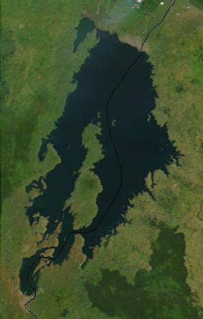
Lake Kivu
Lake · 2,693 km²
Lake Kivu is a lake in the DR Congo and Rwanda, with a mapped surface area of about 2,693 km². About 44% of its surface lies in Rwanda, and the rest in the DR Congo.
Lake Kivu () is one of the African Great Lakes. It lies on the border between the Democratic Republic of the Congo and Rwanda, and is in the Albertine Rift, the western branch of the East African Rift. Lake Kivu empties into the Ruzizi River, which flows southwards into Lake Tanganyika.
In the past, Lake Kivu drained toward the north, contributing to the White Nile. About 13,000 to 9,000 years ago, volcanic activity blocked Lake Kivu's outlet to the watershed of the Nile. The volcanism produced mountains, including the Virungas, which rose between Lake Kivu and Lake Edward, to the north. Water from Lake Kivu was then forced south down the Ruzizi. This, in turn, raised the level of Lake Tanganyika, which overflowed down the Lukuga River.
Lake Kivu is one of three lakes in the world, along with Lake Nyos and Lake Monoun, that undergo limnic eruptions (where overturn of deepwater stratified layers releases dissolved carbon dioxide (CO2)). The lake's bottom also contains methane (CH4). If a limnic eruption occurs, the lives of the two million people living nearby would be in danger.
Adapted from Wikipedia: Lake Kivu (CC BY-SA 4.0).
- Surface area
- 2,693 km²
- Area rank
- #75 of 756 indexed
- Type
- Lake
- Countries
- DR Congo, Rwanda
- Coordinates
- -1.8067°, 29.1458°
Among the 756 water bodies with a mapped extent in YearMaps, Lake Kivu ranks #75 by surface area, after Lake Peipus (2,758 km²) and ahead of Iliamna Lake (2,677 km²). Areas are computed from the mapped outline and are approximate.
More about Lake Kivu
Geography
Lake Kivu is approximately 42 km (26 mi) long and 50 km (31 mi) at its widest. Its irregular shape makes measuring its precise surface area difficult; it has been estimated to cover a total surface area of some 2,700 km2 (1,040 sq mi), making it Africa's eighth largest lake. The surface of the lake sits at a height of 1,460 metres (4,790 ft) above sea level. This lake has a chance of suffering a limnic eruption every 1000 years. The lake has a maximum depth of 475 m (1,558 ft) and a mean depth of 220 m (722 ft), making it the world's twentieth deepest lake by maximum depth, and the thirteenth deepest by mean depth.
The lake bed sits upon a rift valley that is slowly being pulled apart, causing volcanic activity in the area.
Sections adapted from Wikipedia: Lake Kivu (CC BY-SA 4.0).
Lake Kivu: Key Facts
| Surface area | 2,700 km² |
|---|---|
| Maximum depth | 485 m |
| Surface elevation | 1,463 m |
| Inflows | Karundura |
| Outflows | Ruzizi River |
Facts from Wikidata Q125912 (CC0).
Rivers in Rwanda
1 river recorded. Listed alphabetically. A river is listed where its mapped reach lies, so long rivers appear under more than one country.
| Name | Type | Also Flows Through |
|---|---|---|
| Kagera | River | Tanzania, Burundi, Uganda |
UNESCO World Heritage Sites in Rwanda
1 World Heritage Site recorded. Listed by year of inscription, earliest first. Sites shared with another country appear under each.
| # | Name | Inscribed | Type | Criteria |
|---|---|---|---|---|
| 1 | Nyungwe Forest | 2023 | Natural | (x) |
Mountain Ranges, Deserts and Landforms of Rwanda
2 mountain ranges, deserts and other landforms recorded. Ranked by mapped area. Covers mountain ranges, deserts, plateaus, named glaciers, plains, basins, peninsulas and capes. One that crosses a border is listed under every country it lies in, with the area of the whole feature.
| # | Name | Area | Type | Region |
|---|---|---|---|---|
| 1 | Congo Basin | 3.11M km² | Basin | Africa |
| 2 | Great Rift Valley | 163,247 km² | Valley | Africa |

Congo Basin
Basin · 3.11M km²
Congo Basin is a basin in Africa, covering an estimated 3.11M km². It extends across the DR Congo, the Central African Republic, Angola, the Republic of the Congo, Cameroon, South Sudan, Sudan, Burundi, Gabon, Malawi, Rwanda, Uganda and Zambia. It is the 11th-largest of the 231 landforms with a mapped extent in YearMaps.
The Congo Basin is the sedimentary basin of the Congo River. The Congo Basin is located in Central Africa, in a region known as west equatorial Africa. The region is sometimes known simply as the Congo. It contains some of the largest tropical rainforests in the world and is an important source of water used in agriculture and energy generation.
The rainforest in the Congo Basin is the largest rainforest in Africa and second only to the Amazon rainforest in size, with 300 million hectares compared to the 800 million hectares in the Amazon. Because of its size and diversity the basin's forest is important for mitigating climate change in its role as a carbon sink. However, deforestation and degradation of the ecology by the impacts of climate change may increase stress on the forest ecosystem, in turn making the hydrology of the basin more variable. A 2012 study finds that the variability in precipitation caused by climate change will negatively affect economic activity in the basin.
Eight sites of the Congo Basin are inscribed on the World Heritage List, five being also on the list of World Heritage in Danger (all five located in Democratic Republic of the Congo).
Adapted from Wikipedia: Congo Basin (CC BY-SA 4.0).
- Feature class
- Basin
- Mapped extent
- 3.11M km²
- Size rank
- #11 of 231 landforms
- Region
- Africa
- Countries
- DR Congo, Central African Republic, Angola, Republic of the Congo, Cameroon, South Sudan, Sudan, Burundi, Gabon, Malawi, Rwanda, Uganda, Zambia
- Coordinates
- -0.6351°, 21.4534°
- Summits:
- Volcan Karisimbi (4,519 m)
- Ranges:
- Ruwenzori Range (Africa), Marrah Mountains (Africa)
More about Congo Basin
Geology
The Congo Basin is a large depression within the Congo Craton, making it a patch of relatively recent (Phanerozoic-aged, and mostly Mesozoic and onwards) sedimentary rock within a large, otherwise ancient (Archean-aged) piece of exposed continental crust. The deformation of the craton began as early as the late Cambrian or early Ordovician and continued over the Paleozoic, but the deformation over this period led to rapid erosion of much of the Paleozoic rock, creating a large unconformity. Sediment started to rapidly accumulate in the basin from the Mesozoic (Triassic) up to the present day.
Deposits throughout the Jurassic suggest the presence of a freshwater, lacustrine habitat in the basin, and this continued into the Early Cretaceous.
Climate
The Congo Basin is a globally important climatic region with annual rainfall of between 1,500 to 2,000 millimetres (59 to 79 in). It is one of three hotspots of deep convection (thunderstorms) in the tropics, the other two being over the Maritime continent and the Amazon. These three regions together drive the climate circulation of the tropics and beyond. The Congo Basin has the highest lightning strike frequency of anywhere on the planet. The high rainfall supports the second-largest rainforest on Earth, which is a globally significant carbon sink and an important component of the global carbon cycle.
Averaged across the basin, there are two major rainfall seasons in March to May and September to November.
Ecology and protection
At a global level, Congo's forests act as the planet's second lung, counterpart to the rapidly dwindling Amazon. They are a huge "carbon sink", trapping carbon that could otherwise remain carbon dioxide. The Congo Basin holds roughly 8% of the world's forest-based carbon. Despite this importance, it gets far less scientific attention than the Amazon or the tropical forests of South East Asia. If these woodlands are deforested, the carbon they trap will be released into the atmosphere. Predictions for future unabated deforestation estimate that by 2050 activities in the DRC will release roughly the same amount of carbon dioxide as the United Kingdom has emitted over the last 60 years. A 2013 study by British scientists shows that deforestation in the Congo Basin rainforest is slowing.
History
The first inhabitants of the Congo Basin area were believed to be pygmies, and at that time, the dense forests and wet climate kept the population of the region low, with the prevention of hunter-gatherer society, whose remnants of their culture survive to the present day. Eventually Bantu peoples migrated there and founded the Kingdom of Kongo.Belgium, France, and Portugal later established colonial control over the entire region by the late 19th century.
Sections adapted from Wikipedia: Congo Basin (CC BY-SA 4.0).
Congo Basin: Key Facts
| Area | 1,000,000 km² |
|---|---|
| Highest point | Mount Karisimbi |
| On | River Congo |
Facts from Wikidata Q932289 (CC0).
States and Provinces of Rwanda
1 first-level divisions with their own map.
Countries Bordering Rwanda
Land and maritime neighbours.
More Maps in Africa
Rwanda: Quick Answers
- What is the capital of Rwanda?
- The capital of Rwanda is Kigali.
- What is the population of Rwanda?
- Rwanda has a population of about 14.57 million, the #77 largest of 225 countries in YearMaps. Source: World Bank, 2025.
- How big is Rwanda?
- Rwanda covers 26,338 km², ranking #150 by area, with about 553 people per square kilometre.
- Which continent is Rwanda in?
- Rwanda is in Africa.
- Which countries border Rwanda?
- Rwanda shares a land or maritime border with Tanzania, Burundi, DR Congo, Uganda.
- What is the largest city in Rwanda?
- Kigali is the largest city in Rwanda, with a metropolitan population of about 860,000.
- What is the highest mountain in Rwanda?
- The highest summit recorded for Rwanda in YearMaps is Volcan Karisimbi at 4,519 m (14,826 ft). Summits on a border are counted for both countries.
- What is the largest lake in Rwanda?
- The largest lake recorded in or bordering Rwanda is Lake Kivu, at roughly 2,693 km².