
UNESCO World Heritage Sites in Israel
Israel has 7 sites on the UNESCO World Heritage List (7 cultural), the first inscribed in 2001 (Acre). The map below plots every one of them alongside the rest of the List, and each site is written up in full further down the page.
- World Heritage Sites
- 7
- Cultural
- 7
- Natural and Mixed
- 0
- First Inscribed
- 2001
Map of World Heritage Sites in Israel
CulturalNaturalMixedIn DangerLarge dots are in Israel. Click a dot to read about the site.

Acre
Israel · 32.9261° N, 35.0839° E · 1 km² · 15 km from Haifa
Acre ( AH-kər, AY-kər), known in Hebrew as Akko (Hebrew: עַכּוֹ, ʻAkkō, IPA: [ˈako]) and in Arabic as Akka (Arabic: عكّا, ʻAkkā, IPA: [ˈʕak.ka]), is a city in the coastal plain region of the Northern District of Israel.
The city occupies a strategic location, sitting in a natural harbour at the extremity of Haifa Bay on the coast of the Mediterranean's Levantine Sea. Aside from coastal trading, it was an important waypoint on the region's coastal road and the road cutting inland along the Jezreel Valley. The first settlement during the Early Bronze Age was abandoned after a few centuries but a large town was established during the Middle Bronze Age. Continuously inhabited since then, it is among the oldest continuously inhabited settlements on Earth. It has, however, been subject to conquest and destruction several times and survived as little more than a large village for centuries at a time.
Acre was a hugely important city during the Crusades as a maritime foothold on the Mediterranean coast of the southern Levant and was the site of several battles, including the 1189–1191 Siege of Acre and 1291 Siege of Acre.
Adapted from Wikipedia: Acre, Israel (CC BY-SA 4.0).
Why Acre Is Listed
- (ii)
- An important interchange of human values.
- (iii)
- A unique testimony to a cultural tradition or civilisation.
- (v)
- An outstanding example of traditional human settlement or land use.
More about Acre
UNESCO's Description
Acre is a historic walled port-city with continuous settlement from the Phoenician period. The present city is characteristic of a fortified town dating from the Ottoman 18th and 19th centuries, with typical urban components such as the citadel, mosques, khans and baths. The remains of the Crusader town, dating from 1104 to 1291, lie almost intact, both above and below today's street level, providing an exceptional picture of the layout and structures of the capital of the medieval Crusader kingdom of Jerusalem.
From the UNESCO World Heritage Centre (CC BY-SA IGO 3.0).
History
Acre lies at the northern end of a wide bay with Mount Carmel at the south. It is the best natural roadstead on the southern Phoenician coast and has easy access to the Valley of Jezreel. It was settled early and has always been important for the fleets of kingdoms and empires contesting the area, serving as the main port for the entire southern Levant up to the modern era.
The ancient town was located atop Tel ʿAkkō (Hebrew) or Tell al-Fuḫḫār (Arabic, Tel el-Foukhar, meaning "tell of the clay/sherds"), 1.5 km (0.93 mi) east of the present city and 800 m (2,600 ft) north of the Na'aman River. In antiquity, however, it formed an easily protected peninsula directly beside the former mouth of the Na'aman or Belus.
Sections adapted from Wikipedia: Acre, Israel (CC BY-SA 4.0).

Masada
Israel · 31.3156° N, 35.3539° E · 3 km² · 35 km from Al Khalil
Masada (Hebrew: מְצָדָה məṣādā, 'fortress'; Arabic: جبل مسعدة, romanized: jabal musayda, lit. 'mount museida') is a mountain-top fortress complex in the Judaean Desert, overlooking the western shore of the Dead Sea in southeastern Israel. The fort, built in the first century BC, was constructed atop a natural plateau rising over 400 m (1,300 ft) above the surrounding terrain, 20 km (12 mi) east of modern Arad.
The most significant remains at the site date to the reign of Herod the Great, King of Judaea under Roman administration c. 37–4 BC, who transformed Masada into a fortified desert refuge early in his rule. He enclosed the summit with a casemate wall and towers, and constructed storerooms, an advanced water system, and bathhouses, along with two elaborate palaces: one on the western side and another built across three terraces on the northern cliff. These palaces remain among the finest examples of Herodian architecture.
Masada is most renowned for its role during the First Jewish–Roman War (66–73 AD), when it became the final holdout of Jewish rebels following the destruction of Jerusalem.
Adapted from Wikipedia: Masada (CC BY-SA 4.0).
Why Masada Is Listed
- (iii)
- A unique testimony to a cultural tradition or civilisation.
- (iv)
- An outstanding example of a type of building or landscape.
- (vi)
- A direct association with events, ideas or beliefs of universal significance.
Archaeological Record: Masada Fortress
Isolated mesa fortress above the Dead Sea built by Herod the Great; site of the epic 73 CE siege where Legio X Fretensis built a colossal earth assault ramp.
- Site type
- Cliff Citadel & Roman Siege Works
- Ancient name
- Masada
- Ancient province
- Judaea
- Occupation
- 37 BCE to 73 CE
Pleiades gazetteer: 687968
More about Masada
UNESCO's Description
Masada is a rugged natural fortress, of majestic beauty, in the Judaean Desert overlooking the Dead Sea. It is a symbol of the ancient kingdom of Israel, its violent destruction and the last stand of Jewish patriots in the face of the Roman army, in 73 A.D. It was built as a palace complex, in the classic style of the early Roman Empire, by Herod the Great, King of Judaea, (reigned 37 – 4 B.C.). The camps, fortifications and attack ramp that encircle the monument constitute the most complete Roman siege works surviving to the present day.
From the UNESCO World Heritage Centre (CC BY-SA IGO 3.0).
Geography
The cliff of Masada is, geologically speaking, a horst. As the plateau abruptly ends in cliffs steeply falling about 400 m (1,300 ft) to the east and about 90 m (300 ft) to the west, the natural approaches to the fortress are very difficult to navigate. The top of the mesa-like plateau is flat and rhomboid-shaped, about 550 m (1,800 ft) by 270 m (890 ft). Herod built a 4 m (13 ft) high casemate wall around the plateau totaling 1,300 m (4,300 ft) in length, reinforced by many towers. The fortress contained storehouses, barracks, an armory, a palace, and a series of cisterns (capacity around 40,000 m3; 1.4 million cu ft) that were refilled by rainwater – with the runoff collected from a single day's rain allegedly able to sustain over 1,000 people for 2 to 3 years.
History
Almost all historical information about Masada comes from the first-century Jewish Roman historian Josephus. Masada is also mentioned in the Judean Desert Documents.
Josephus writes that the site was first fortified by Hasmonean ruler Alexander Jannaeus in the first century BC. However, so far no Hasmonean-period building remains could be identified during archaeological excavations.
Josephus further writes that Herod the Great captured it in the power struggle that followed the death of his father Antipater in 43 BC. It survived the siege of the last Hasmonean king Antigonus II Mattathias, who ruled with Parthian support.
Modern tourism
In 2007, the Masada Museum in Memory of Yigael Yadin opened at the site, in which archeological findings are displayed in a theatrical setting. Many of the artifacts exhibited were unearthed by Yadin and his archaeological team from the Hebrew University of Jerusalem during the 1960s.
The Snake Trail leaves from the eastern side at the Masada Museum (access via the Dead Sea Highway) and gains around 301 m (988 ft) in elevation.
The Roman Ramp trail is also very steep, but has less elevation gain, and is accessed from the western side of the mountain (with access by car from the Arad road).
Hikers frequently start an hour before sunrise, when the park opens, to avoid the mid-day heat, which can exceed 43 °C (109 °F) in the summer.
Sections adapted from Wikipedia: Masada (CC BY-SA 4.0).
Visiting Masada
Masada (Hebrew: מצדה) is a magnificently located fortress site in Israel's stark Judaean Desert, close to the Dead Sea. The last Jewish holdout to fall to Rome in 73 CE, Masada symbolizes the exile of the Jewish nation from the Holy Land. Its violent end has become a symbol of bravery and self-sacrifice since the founding of the State of Israel in 1948.
Travel notes adapted from Wikivoyage: Masada (CC BY-SA 4.0).

White City
Israel · 32.0778° N, 34.7739° E · 1 km² · 1 km from Tel Aviv-Yafo
The White City (Hebrew: העיר הלבנה, Ha-Ir ha-Levana; Arabic: المدينة البيضاء Al-Madinah al-Bayḍā’) is a collection of over 4,000 buildings in Tel Aviv from the 1930s built in a unique form of the International Style, commonly known as Bauhaus, by German Jewish architects who fled to the British Mandate of Palestine from Germany (and other Central and Eastern European countries with German cultural influences) after the rise to power of the Nazis. Tel Aviv has the largest number of buildings in the Bauhaus/International Style of any city in the world. Preservation, documentation, and exhibitions have brought attention to Tel Aviv's collection of 1930s architecture. In 2003, the United Nations Educational, Scientific and Cultural Organization (UNESCO) proclaimed Tel Aviv's White City a World Cultural Heritage site, as "an outstanding example of new town planning and architecture in the early 20th century." The citation recognized the unique adaptation of modern international architectural trends to the cultural, climatic, and local traditions of the city. Bauhaus Center Tel Aviv organizes regular architectural tours of the city.
Adapted from Wikipedia: White City, Tel Aviv (CC BY-SA 4.0).
Why White City Is Listed
- (ii)
- An important interchange of human values.
- (iv)
- An outstanding example of a type of building or landscape.
More about White City
UNESCO's Description
Tel Aviv was founded in 1909 and developed as a metropolitan city under the British Mandate in Palestine. The White City was constructed from the early 1930s until the 1950s, based on the urban plan by Sir Patrick Geddes, reflecting modern organic planning principles. The buildings were designed by architects who were trained in Europe where they practised their profession before immigrating. They created an outstanding architectural ensemble of the Modern Movement in a new cultural context.
From the UNESCO World Heritage Centre (CC BY-SA IGO 3.0).
Adaptation to local climate
The architecture had to be adapted to suit the extremes of the Mediterranean and desert climate. White and light colors reflected the heat. Walls not only provided privacy but protected against the sun. Large areas of glass that let in the light, a key element of the Bauhaus style in Europe, were replaced with small recessed windows that limited the heat and glare. Long, narrow balconies, each shaded by the balcony above it, allowed residents to catch the breeze blowing in from the sea to the west. Pitched roofs were replaced with flat ones, providing a common area where residents could socialize in the cool of the evening.
Buildings were raised on pillars (pilotis), the first being the 1933 Engel House designed by Zeev Rechter.
History
The concept for a new garden city, to be called Tel Aviv, was developed on the sand dunes outside Jaffa in 1909. Scottish urban planner Patrick Geddes, who had previously worked on town-planning in New Delhi, was commissioned by Tel Aviv's first mayor, Meir Dizengoff, to draw up a master plan for the new city. Geddes began work in 1925 on the plan, which was accepted in 1929. The view of the British Mandatory authorities seemed to have been supportive. In addition to Geddes, and Dizengoff, the city engineer Ya'acov Ben-Sira contributed significantly to the development and planning during his 1929 to 1951 tenure.
Patrick Geddes laid out the streets and decided on block size and utilisation. Geddes did not prescribe an architectural style for the buildings in the new city.
Sections adapted from Wikipedia: White City, Tel Aviv (CC BY-SA 4.0).
Biblical Tels - Megiddo, Hazor, Beer Sheba
Israel · 32.5972° N, 35.1822° E · 1 km² · 16 km from Nazareth
Tels (prehistoric settlement mounds), are characteristic of the flatter lands of the eastern Mediterranean, particularly Lebanon, Syria, Israel and eastern Turkey. Of more than 200 tels in Israel, Megiddo, Hazor and Beer Sheba are representative of those that contain substantial remains of cities with biblical connections. The three tels also present some of the best examples in the Levant of elaborate Iron Age, underground water-collecting systems, created to serve dense urban communities. Their traces of construction over the millennia reflect the existence of centralized authority, prosperous agricultural activity and the control of important trade routes.
Description from the UNESCO World Heritage Centre (CC BY-SA IGO 3.0).
Why Biblical Tels - Megiddo, Hazor, Beer Sheba Is Listed
- (ii)
- An important interchange of human values.
- (iii)
- A unique testimony to a cultural tradition or civilisation.
- (iv)
- An outstanding example of a type of building or landscape.
- (vi)
- A direct association with events, ideas or beliefs of universal significance.

Nahal Me'arot Nature Reserve
Israel · 32.6708° N, 34.9661° E · 1 km² · 17 km from Haifa
The Caves of Nahal Me’arot / Wadi el-Mughara ("Caves Creek"), named here by the Hebrew and Arabic name of the valley where they are located, are a UNESCO Site of Human Evolution in the Carmel mountain range near Haifa in northern Israel.
The four caves were proclaimed a site of "outstanding universal value" by UNESCO in 2012. They are protected within a nature reserve.
The caves were used for habitation by hominins and prehistoric humans and contain unique evidence of very early burials, at the archaeological site of el-Wad cave in the Nahal Me'arot Nature Reserve.
Adapted from Wikipedia: Nahal Me'arot Nature Reserve (CC BY-SA 4.0).
Why Nahal Me'arot Nature Reserve Is Listed
- (iii)
- A unique testimony to a cultural tradition or civilisation.
- (v)
- An outstanding example of traditional human settlement or land use.
More about Nahal Me'arot Nature Reserve
UNESCO's Description
Situated on the western slopes of the Mount Carmel range, the site includes the caves of Tabun, Jamal, el-Wad and Skhul. Ninety years of archaeological research have revealed a cultural sequence of unparalleled duration, providing an archive of early human life in south-west Asia. This 54 ha property contains cultural deposits representing at least 500,000 years of human evolution demonstrating the unique existence of both Neanderthals andEarly Anatomically Modern Humans within the same Middle Palaeolithic cultural framework, the Mousterian. Evidence from numerous Natufian burials and early stone architecture represents the transition from a hunter-gathering lifestyle to agriculture and animal husbandry. As a result, the caves have become a key site of the chrono-stratigraphic framework for human evolution in general, and the prehistory of the Levant in particular.
From the UNESCO World Heritage Centre (CC BY-SA IGO 3.0).
Beit Guvrin National Park
Israel · 31.6131° N, 34.8983° E · 3 km² · 20 km from Al Khalil
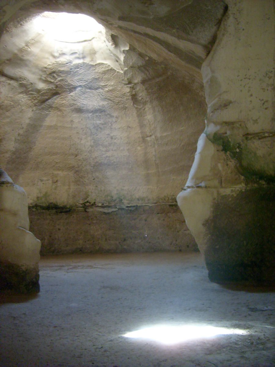
Beit Guvrin-Maresha National Park is a national park in the Judaean Foothills of central Israel, containing a large network of caves recognized by UNESCO as a World Heritage Site.
The national park includes the remains of two historical towns. The first, Maresha, was an important town of the Kingdom of Judah during the First Temple period, which later continued through the Persian and Hellenistic periods and came to be inhabited largely by Idumeans. It is located in the southern part of the park. The northern part contains the remains of Beit Guvrin, a settlement that developed after the destruction of Maresha by the Parthians in 40 BCE and became the main town of the region. It was devastated in the Jewish–Roman wars, rebuilt, and in 200 CE it was elevated to city status and given the Greek name Eleutheropolis. After the Muslim conquest it became known as Bayt Jibrin, remaining a village (with a period of Crusader rule) until it was depopulated in 1948. Archaeological artifacts unearthed at the site include a large Jewish cemetery, a Roman-Byzantine amphitheater, a Byzantine church, public baths, mosaics and burial caves.
Adapted from Wikipedia: Beit Guvrin-Maresha National Park (CC BY-SA 4.0).
Why Beit Guvrin National Park Is Listed
- (v)
- An outstanding example of traditional human settlement or land use.
More about Beit Guvrin National Park
UNESCO's Description
The archaeological site contains some 3,500 underground chambers distributed among distinct complexes carved in the thick and homogenous soft chalk of Lower Judea under the former towns of Maresha and Bet Guvrin. Situated on the crossroads of trade routes to Mesopotamia and Egypt, the site bears witness to the region’s tapestry of cultures and their evolution over more than 2,000 years from the 8 th century BCE—when Maresha, the older of the two towns was built—to the time of the Crusaders. These quarried caves served as cisterns, oil presses, baths, columbaria (dovecotes), stables, places of religious worship, hideaways and, on the outskirts of the towns, burial areas. Some of the larger chambers feature vaulted arches and supporting pillars.
From the UNESCO World Heritage Centre (CC BY-SA IGO 3.0).
Historical overview
The national park includes the remains of two historical towns: Maresha, located in the south, and Beit Guvrin, located in the north. It is located 13 kilometers from Kiryat Gat.
Tel Maresha (Modern Hebrew) or Tell Sandahannah (Arabic) is the site of Iron Age (biblical) Mareshah, which continued through the Persian and into the Hellenistic period. The earliest written record of Mareshah was as a city in ancient Judah (Joshua 15:44). The city of mu-ukh-ra-ash-ti, sometimes rendered in English as Muhrashti, of the Amarna Letters (14th century BCE, during the Early Bronze Age) is unlikely to be the predecessor of Iron Age Maresha, as no remains older than the Iron Age were unearthed there by archaeologists.
Sections adapted from Wikipedia: Beit Guvrin-Maresha National Park (CC BY-SA 4.0).

Beit She'arim National Park
Israel · 32.7042° N, 35.1281° E · 16 km from Nazareth
Beit She'arim Necropolis (Hebrew: בֵּית שְׁעָרִים, "House of Gates") is an extensive rock-cut necropolis located near the ancient Jewish town of Beit She'arim, 20 km east of Haifa in the southern foothills of the Lower Galilee. Part of Beit She'arim National Park, the site includes the necropolis and remains of the town. Used from the first to fourth centuries CE, its peak occurred in the late second century when the Sanhedrin, led by Judah ha-Nasi, relocated to Beit She'arim, and his family was interred there. In 2015, the necropolis was designated a UNESCO World Heritage Site.
The necropolis is carved out of soft limestone and contains more than 30 burial cave systems. When 20th-century archaeologists first explored the catacombs, the tombs had already fallen into great disrepair and neglect, and the sarcophagi contained therein had almost all been broken into by grave robbers in search of treasure. This pillaging was believed to have happened in the 8th and 9th centuries based on the type of terracotta oil lamps found in situ. The robbers also emptied the stone coffins of the bones of the deceased.
Adapted from Wikipedia: Beit She'arim necropolis (CC BY-SA 4.0).
Why Beit She'arim National Park Is Listed
- (ii)
- An important interchange of human values.
- (iii)
- A unique testimony to a cultural tradition or civilisation.
More about Beit She'arim National Park
UNESCO's Description
Consisting of a series of catacombs, the necropolis developed from the 2 nd century AD as the primary Jewish burial place outside Jerusalem following the failure of the second Jewish revolt against Roman rule. Located southeast of the city of Haifa, these catacombs are a treasury of artworks and inscriptions in Greek, Aramaic, Hebrew and Palmyrene. Bet She’arim bears unique testimony to ancient Judaism under the leadership of Rabbi Judah the Patriarch, who is credited with Jewish renewal after 135 AD.
From the UNESCO World Heritage Centre (CC BY-SA IGO 3.0).
History of the settlement
The national park is managed by the National Parks Authority. It borders the town of Kiryat Tiv'on on the northeast and is located five kilometres west of the moshav named after the historical location in 1926, a decade prior to its archaeological identification. In early modern times the site was the Arab village of Sheikh Bureik; it was depopulated in the 1920s as a result of the Sursock Purchases, and identified as Beit She'arim in 1936 by historical geographer Samuel Klein.
Pottery shards discovered at the site indicate that a first settlement there dates back to the Iron Age.
Beit She'arayim was founded at the end of the 1st century BCE, during the reign of King Herod.
Sections adapted from Wikipedia: Beit She'arim necropolis (CC BY-SA 4.0).
Key Facts
| Established | 1936 |
|---|---|
| Area | 0.1 km² |
Facts from Wikidata Q830805 (CC0).
World Heritage in Israel: Quick Answers
- How many UNESCO World Heritage Sites are in Israel?
- Israel has 7 World Heritage Sites: 7 cultural.
- What was the first World Heritage Site in Israel?
- Acre, inscribed in 2001. The most recent is Beit She'arim National Park, inscribed in 2015.
- Are any World Heritage Sites in Israel in danger?
- None of the World Heritage Sites in Israel is on UNESCO's List of World Heritage in Danger.