Skip to content
YearMaps
Argentina · Lakes

Largest Lakes in Argentina

Mar Chiquita is the largest of the 14 lakes recorded for Argentina, at 2,102 km², ahead of Lago Buenos Aires at 1,895 km². The full list follows.

How this list is built: Ranked by mapped surface area. A lake on a border is listed under each country it lies in, with the area of the whole lake. It covers the lakes indexed in YearMaps, drawn from open geospatial data, and is not an exhaustive national register.

Lakes Listed
14
Top Ranked
2,102 km²
Mar Chiquita
Second
1,895 km²
Lago Buenos Aires
Profiled Below
8
Photo, encyclopedia text and figures
Largest Lakes in Argentina
#NameSurface Area
1Mar Chiquita2,102 km²
2Lago Buenos Aires1,895 km²
3Lago Argentino1,450 km²
4Lago Viedma1,077 km²
5Lago San Martín1,053 km²
6Embalse Ezequiel Ramos Mexia819 km²
7Lago Colhu Huapi791 km²
8Lago Nahuel Huapí553 km²
9Lago Musters381 km²
10Lago Cardiel350 km²
11Laguna Iber311 km²
12Laguna Iber184 km²
13Lago La Plata77 km²
14Lago Fontana67 km²

The Lakes of Argentina in Detail

The 8 lakes above that have an encyclopedia article, in the same order, each with its photograph, figures and the places around it.

Mar Chiquita
Image via Wikimedia Commons (author and licence on the file page).

Mar Chiquita

Alkaline Lake · 2,102 km²

Mar Chiquita is a alkaline lake in Argentina, with a mapped surface area of about 2,102 km².

Mar Chiquita (in Spanish literally "Little Sea") or Mar de Ansenuza is an endorheic salt lake located in the northeast of the province of Córdoba, in central Argentina. The northeast corner of the lake also extends into southeastern Santiago del Estero Province. It is the largest of the naturally occurring saline lakes in Argentina. The lake is located in parts of five departments in the two provinces.

The lake is in the Argentine Espinal ecoregion.

It occupies the southern part of a depression that measures about 50 miles/80 km (north–south) by 28 miles/45 km (east–west). Its surface area varies considerably, given its shallow depth (about 10 m), and ranges between 2,000 and 6,000 km2 (770 and 2,320 mi2).

Adapted from Wikipedia: Mar Chiquita Lake (CC BY-SA 4.0).

Surface area
2,102 km²
Area rank
#93 of 756 indexed
Type
Alkaline Lake
Country
Argentina
Coordinates
-30.7050°, -62.5594°

Among the 756 water bodies with a mapped extent in YearMaps, Mar Chiquita ranks #93 by surface area, after Lake Bangweulu (2,125 km²) and ahead of Lake Barlee (2,101 km²). Areas are computed from the mapped outline and are approximate.

Settlements on the shore:
San Francisco (92 km), Rafaela (118 km), Córdoba (173 km)
Watercourses:
Tercero (River), Carcarañá (River)
Other water nearby:
Lago Rincon del Bonete (1,563 km²), Lagoa Mirim (3,845 km²)

View on the live map

More about Mar Chiquita

Hydrology

Mar Chiquita is fed primarily by the saline waters of the Dulce River, coming from Santiago del Estero in the north after being joined by the Saladillo River. The lands around the lower course of the Dulce and Mar Chiquita are wetlands, populated by a large biodiversity (especially aquatic birds). From the southwest the lake receives the flow of the Primero/Suquía and the Segundo/Xanaes rivers, as well as several streams; these inflows vary greatly from dry to rainy seasons. The salinity of Mar Chiquita is quite variable, with measured extremes ranging from 250 g/L in times of low water levels to around 40 g/L in very humid years, such as in the decade following 1977, when record rainfall flooded much of Miramar, Córdoba.

Sections adapted from Wikipedia: Mar Chiquita Lake (CC BY-SA 4.0).

Mar Chiquita: Key Facts

Key facts about Mar Chiquita
Surface area5,770 km²
Maximum depth10 m
Volume2.39 km³
Surface elevation71 m
InflowsDulce River, Primero River, Segundo River

Facts from Wikidata Q782399 (CC0).
Lago Buenos Aires
Image via Wikimedia Commons (author and licence on the file page).

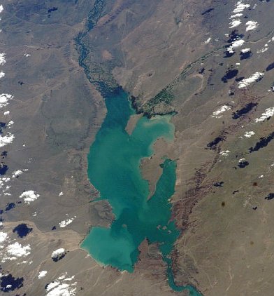
Lago Buenos Aires

Lake · 1,895 km²

Lago Buenos Aires is a lake in Chile and Argentina, with a mapped surface area of about 1,895 km². About 42% of its surface lies in Argentina, and the rest in Chile.

General Carrera Lake (Chilean part, officially renamed in 1959) or Lake Buenos Aires (Argentine part) is a deep lake located in Patagonia and shared by Argentina and Chile. Both names are internationally accepted, while the autochthonous name of the lake is Chelenko, which means "stormy waters" in Aonikenk. Another historical name is Coluguape from Mapuche, a derivative of this name is applied to Colhué Huapí Lake after Argentine explorer Francisco Moreno reached this lake in 1876 conflating it with Coluguape (General Carrera Lake).

The lake is of glacial origin and is surrounded by the Andes mountain range. The lake drains to the Pacific Ocean on the west through the Baker River. During the last glaciation the lake drained to the Atlantic through Deseado River.

The weather in this area of Chile and Argentina is generally cold and humid. But the lake itself has a sunny microclimate, a weather pattern enjoyed by the few settlements along the lake, such as Puerto Guadal, Fachinal, Mallín Grande, Puerto Murta, Puerto Río Tranquilo, Puerto Sánchez, Puerto Ingeniero Ibáñez and Chile Chico in Chile, and Los Antiguos and Perito Moreno in Argentina.

Adapted from Wikipedia: General Carrera Lake (CC BY-SA 4.0).

Surface area
1,895 km²
Area rank
#106 of 756 indexed
Type
Lake
Countries
Chile, Argentina
Coordinates
-46.4820°, -71.5198°

Among the 756 water bodies with a mapped extent in YearMaps, Lago Buenos Aires ranks #106 by surface area, after Kremenchuk Reservoir (1,897 km²) and ahead of Nam Co (1,880 km²). Areas are computed from the mapped outline and are approximate.

Settlements on the shore:
Comodoro Rivadavia (314 km), Esquel (398 km), San Carlos de Bariloche (592 km)
Watercourses:
Deseado (River), Chubut (River)
Other water nearby:
Lago Musters (381 km²), Lago Cardiel (350 km²)

View on the live map

More about Lago Buenos Aires

Geology

The lake occupies a continental-scale graben formed by SWS-ENE normal faults that have resulted in down-dropping the bottom of the lake to 350 meters (1,150 ft) below mean sea level. Preservation of younger lithostratigraphic units within the graben form reverse stratigraphy with older units exposed at higher topographic elevations to the south. The graben channeled mountain glaciers which formed terminal moraine helping to modify the present-day shape of the lake. The tectonic activity that formed the depression can be inferred to subduction of the triple joint that has occurred over the past 20 million years, as indicated by ripple marks in volcaniclastic sediments observed along the southern shoreline.

Sections adapted from Wikipedia: General Carrera Lake (CC BY-SA 4.0).

Lago Buenos Aires: Key Facts

Key facts about Lago Buenos Aires
Surface area1,850 km²
Maximum depth590 m
Surface elevation202 m
OutflowsBaker River
Drainage systemBaker Basin

Facts from Wikidata Q503842 (CC0).

Lago Argentino
Image via Wikimedia Commons (author and licence on the file page).

Lago Argentino

Lake · 1,450 km²

Lago Argentino is a lake in Argentina, with a mapped surface area of about 1,450 km².

Lago Argentino is a lake in the Patagonian province of Santa Cruz, Argentina. It is the largest freshwater lake in Argentina, with a surface area of 1,415 km2 (546 mi2) and a maximum width of 20 mi (32 km). The lake's waters have an average depth of 155 m (509 ft), with a maximum depth of 719 m (2,359 ft). The deepest point of the lake is situated in the end of its narrow north-northwestern arm, in front of the retreating Upsala Glacier. This depth was discovered during a survey in 2001. The south-southwestern arm ends in front of the Perito Moreno Glacier. The glaciers debouch into the lake at these sites, making "trenches" in the bedrock. The lake reaches 541 m (1,775 ft) below mean sea level.

Lago Argentino lies within Los Glaciares National Park in a landscape accented by numerous glaciers, and the lakes of the area are fed by the glacial meltwater of several rivers. For example, the waters of Lake Viedma are fed by the La Leona River, and many other smaller mountain streams. Lago Argentino's drainage basin amounts to more than 17,000 km2 (6,564 mi2). Water from Lake Argentino flows into the Atlantic Ocean through the Santa Cruz River.

Adapted from Wikipedia: Lake Argentino (CC BY-SA 4.0).

Surface area
1,450 km²
Area rank
#141 of 756 indexed
Type
Lake
Country
Argentina
Coordinates
-50.2335°, -72.3929°

Among the 756 water bodies with a mapped extent in YearMaps, Lago Argentino ranks #141 by surface area, after Kasba Lake (1,455 km²) and ahead of Lac la Ronge (1,439 km²). Areas are computed from the mapped outline and are approximate.

Settlements on the shore:
Puerto Natales (165 km), Río Gallegos (272 km), Punta Arenas (341 km)
Watercourses:
Gallegos (River), Deseado (River)
Other water nearby:
Lago Viedma (1,077 km²), Lago San Martín (1,053 km²)

View on the live map

More about Lago Argentino

Lago Argentino: Key Facts

Key facts about Lago Argentino
Surface area1,415 km²
Maximum depth150 m
Surface elevation187 m
InflowsPerito Moreno Glacier, Upsala Glacier, La Leona River
OutflowsSanta Cruz River

Facts from Wikidata Q753898 (CC0).

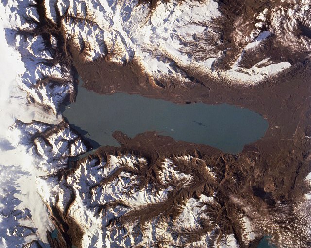
Lago Viedma
Image via Wikimedia Commons (author and licence on the file page).

Lago Viedma

Lake · 1,077 km²

Lago Viedma is a lake in Argentina and Chile, with a mapped surface area of about 1,077 km². About 100% of its surface lies in Argentina, and the rest in Chile.

Viedma Lake (Spanish: Lago Viedma, Spanish pronunciation: [laɣo ˈβjeðma]) is a Patagonian lake in the province of Santa Cruz, Argentina, situated near its border with Chile. Measuring approximately 50 miles (80 km) in length, it is a major elongated trough lake formed from melting glacial ice. Viedma Lake is the second largest perennial lake located entirely within Argentina.

The name of the lake comes from the Spanish explorer Antonio de Viedma, who in 1783 became the first European to reach its shores.

The town of El Chaltén and the Andes peaks Cerro Torre and Fitz-Roy lie in the proximity of the lake.

Lake Viedma is fed primarily by the Viedma Glacier at its western end. The Viedma Glacier measures 3 miles (5 kilometers) wide at its terminus at Lake Viedma. The brown landscape is a result of ice scouring, which left virtually no vegetation on the steep-walled valleys.

Water from Lake Viedma flows into Lake Argentino through the La Leona River, and eventually from there into the Atlantic Ocean through the Santa Cruz River.

Adapted from Wikipedia: Viedma Lake (CC BY-SA 4.0).

Surface area
1,077 km²
Area rank
#181 of 756 indexed
Type
Lake
Countries
Argentina, Chile
Coordinates
-49.6925°, -72.2564°

Among the 756 water bodies with a mapped extent in YearMaps, Lago Viedma ranks #181 by surface area, after Novosibirsk Reservoir (1,082 km²) and ahead of Lake Eyasi (1,077 km²). Areas are computed from the mapped outline and are approximate.

Settlements on the shore:
Río Gallegos (326 km), Comodoro Rivadavia (563 km), Rio Grande (572 km)
Watercourses:
Gallegos (River), Deseado (River)
Other water nearby:
Lago Argentino (1,450 km²), Lago San Martín (1,053 km²)

View on the live map

More about Lago Viedma

Lago Viedma: Key Facts

Key facts about Lago Viedma
Surface area1,088 km²
Surface elevation250 m
InflowsSanta Cruz River, Viedma Glacier, Las Vueltas river
OutflowsSanta Cruz River
Drainage systemSanta Cruz River

Facts from Wikidata Q918713 (CC0).

Lago San Martín
Image via Wikimedia Commons (author and licence on the file page).

Lago San Martín

Lake · 1,053 km²

Lago San Martín is a lake in Argentina and Chile, with a mapped surface area of about 1,053 km². About 53% of its surface lies in Argentina, and the rest in Chile.

The lake known as O'Higgins in Chile and San Martín in Argentina is located around coordinates 48°50′S 72°36′W in Patagonia, between the Aysén Region and the Santa Cruz Province.

Adapted from Wikipedia: O'Higgins/San Martín Lake (CC BY-SA 4.0).

Surface area
1,053 km²
Area rank
#189 of 756 indexed
Type
Lake
Countries
Argentina, Chile
Coordinates
-48.9305°, -72.5386°

Among the 756 water bodies with a mapped extent in YearMaps, Lago San Martín ranks #189 by surface area, after Pyhjrvi (1,054 km²) and ahead of Lac St.-Jean (1,048 km²). Areas are computed from the mapped outline and are approximate.

Settlements on the shore:
Río Gallegos (381 km), Comodoro Rivadavia (506 km), Rio Grande (636 km)
Watercourses:
Gallegos (River), Deseado (River)
Other water nearby:
Lago Viedma (1,077 km²), Lago Cardiel (350 km²)

View on the live map

More about Lago San Martín

History

The lake was divided in the 1902 Arbitral award of the Andes between Argentina and Chile. Disregarding the Chilean agent Bolados and the Argentine agent Arenberg, the demarcator, British Colonel Herbert Leland Crosthwait placed border marker 62 south of Lake O'Higgins/San Martín using a pile of stones and a paper inside a bottle, as he was short on time.

Sections adapted from Wikipedia: O'Higgins/San Martín Lake (CC BY-SA 4.0).

Lago San Martín: Key Facts

Key facts about Lago San Martín
Surface area1,058 km²
Maximum depth836 m
Surface elevation285 m

Facts from Wikidata Q2005708 (CC0).

Embalse Ezequiel Ramos Mexia
Image via Wikimedia Commons (author and licence on the file page).

Embalse Ezequiel Ramos Mexia

Reservoir · 819 km²

Embalse Ezequiel Ramos Mexia is an artificial reservoir in Argentina, with a mapped surface area of about 819 km². It exists because of a dam rather than natural drainage.

The El Chocón Dam (officially the El Chocón–Cerros Colorados Complex) is one of the most iconic engineering works in Patagonia and the Argentine Republic. Located on the Limay River, in the northwestern region of Patagonia known as Comahue, it is 381 meters above sea level and approximately 80 kilometers upstream from the confluence of the Limay and Neuquén Rivers.

Conceived as part of a strategic hydroelectric development and water regulation plan, El Chocón performs vital functions: regulating the flow of the Limay River, ensuring irrigation water in large areas of the Upper and Middle Valleys, and, above all, generating large-scale hydroelectric power. Its plant is the largest in Patagonia and one of the most important in Argentina, with an installed capacity of 1,260 MW.

The dam's construction was carried out by the state-owned company Hidronor (Hidroeléctrica Norpatagónica S.A.), and it marked a milestone in the history of Argentine public works. The first generator began operating in 1972, and the dam reached full generating capacity in 1977. During the period 1974–1995, the plant produced an annual average of 2,700 GWh, becoming a pillar of the national energy supply.

Adapted from Wikipedia: El Chocón Dam (CC BY-SA 4.0).

Surface area
819 km²
Area rank
#227 of 756 indexed
Type
Reservoir
Country
Argentina
Coordinates
-39.5233°, -69.0927°

Among the 756 water bodies with a mapped extent in YearMaps, Embalse Ezequiel Ramos Mexia ranks #227 by surface area, after Pskoyskoye Ozero (825 km²) and ahead of Barragem Itumbiara (812 km²). Areas are computed from the mapped outline and are approximate.

Settlements on the shore:
Cutral Có (66 km), Neuquén (109 km), General Roca (139 km)
Watercourses:
Limay (River), Neuquén (River)
Other water nearby:
Lago Llanquihue (854 km²), Lago Musters (381 km²)

View on the live map

More about Embalse Ezequiel Ramos Mexia

Embalse Ezequiel Ramos Mexia: Key Facts

Key facts about Embalse Ezequiel Ramos Mexia
Surface elevation328 m

Facts from Wikidata Q1287364 (CC0).

Lago Musters
Image via Wikimedia Commons (author and licence on the file page).

Lago Musters

Lake · 381 km²

Lago Musters is a lake in Argentina, with a mapped surface area of about 381 km².

Lake Musters and Lake Colhué Huapi (45°25′S 69°11′W, at altitudes of around 260 metres (850 ft)) form the terminal stage of the Senguerr River endorheic basin, located in the patagonic central region of Argentina in the south of Chubut province. Closest populated area is Sarmiento, an 8,000 inhabitant former Welsh immigrant colony. The lakes gave their names to the Mustersan and Colhuehuapian South American land mammal ages.

Adapted from Wikipedia: Lake Musters and Lake Colhué Huapí (CC BY-SA 4.0).

Surface area
381 km²
Area rank
#362 of 756 indexed
Type
Lake
Country
Argentina
Coordinates
-45.5013°, -69.1999°

Among the 756 water bodies with a mapped extent in YearMaps, Lago Musters ranks #362 by surface area, after Lac Onangu (385 km²) and ahead of Tungabhadra (380 km²). Areas are computed from the mapped outline and are approximate.

Settlements on the shore:
Comodoro Rivadavia (138 km), Coihaique (224 km), Esquel (335 km)
Watercourses:
Deseado (River), Chubut (River)
Other water nearby:
Lago Buenos Aires (1,895 km²), Lago Cardiel (350 km²)

View on the live map

More about Lago Musters

Description

The basin lakes are fed mainly by the eastward running Senguerr river which begins its journey in the glacial lakes La Plata and Fontana in the Andes. The inflow ranges from 35 to 54 m3/sec and varies seasonally and yearly greatly.

Both lakes have naturally a high evaporation process in the dry Patagonian environment by means of strong winds action and solar radiation. In shallow Colhué Huapi evaporation is much increased. In past decades, when excessive inflows did take place, water discharged to the birth branches of Chico River and eventually reached Chubut River. This occasional process last happened in 1939, since then Chico River is mostly a dry one.

Sections adapted from Wikipedia: Lake Musters and Lake Colhué Huapí (CC BY-SA 4.0).

Lago Cardiel

Lake · 350 km²

Lago Cardiel is a lake in Argentina, with a mapped surface area of about 350 km².

Lago Cardiel (Spanish pronunciation: [kaɾˈðjel]) is a lake in Patagonia, Argentina, between the Andean Cordillera and the South Atlantic.

Adapted from Wikipedia: Cardiel Lake (CC BY-SA 4.0).

Surface area
350 km²
Area rank
#379 of 756 indexed
Type
Lake
Country
Argentina
Coordinates
-48.9127°, -71.2102°

Among the 756 water bodies with a mapped extent in YearMaps, Lago Cardiel ranks #379 by surface area, after Xinfengjiang Shuiku (351 km²) and ahead of Aqqikkol Hu (348 km²). Areas are computed from the mapped outline and are approximate.

Settlements on the shore:
Puerto Natales (325 km), Río Gallegos (334 km), Coihaique (377 km)
Watercourses:
Deseado (River), Gallegos (River)
Other water nearby:
Lago San Martín (1,053 km²), Lago Viedma (1,077 km²)

View on the live map

More about Lago Cardiel

Lago Cardiel: Key Facts

Key facts about Lago Cardiel
Surface area345 km²
Maximum depth76 m
Surface elevation276 m

Facts from Wikidata Q2439795 (CC0).

More on Argentina

Quick Answers

What is the largest lake in Argentina?
Mar Chiquita, at 2,102 km². Lago Buenos Aires is second at 1,895 km². Rankings cover the lakes indexed in YearMaps.
How many lakes are there in Argentina?
YearMaps lists 14 lakes for Argentina. This is the number mapped in the atlas, not an official national count.