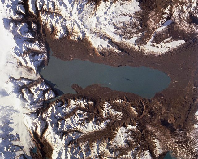
Lago Buenos Aires
Lake · 1,895 km²
Lago Buenos Aires is a lake in Chile and Argentina, with a mapped surface area of about 1,895 km². About 58% of its surface lies in Chile, and the rest in Argentina.
General Carrera Lake (Chilean part, officially renamed in 1959) or Lake Buenos Aires (Argentine part) is a deep lake located in Patagonia and shared by Argentina and Chile. Both names are internationally accepted, while the autochthonous name of the lake is Chelenko, which means "stormy waters" in Aonikenk. Another historical name is Coluguape from Mapuche, a derivative of this name is applied to Colhué Huapí Lake after Argentine explorer Francisco Moreno reached this lake in 1876 conflating it with Coluguape (General Carrera Lake).
The lake is of glacial origin and is surrounded by the Andes mountain range. The lake drains to the Pacific Ocean on the west through the Baker River. During the last glaciation the lake drained to the Atlantic through Deseado River.
The weather in this area of Chile and Argentina is generally cold and humid. But the lake itself has a sunny microclimate, a weather pattern enjoyed by the few settlements along the lake, such as Puerto Guadal, Fachinal, Mallín Grande, Puerto Murta, Puerto Río Tranquilo, Puerto Sánchez, Puerto Ingeniero Ibáñez and Chile Chico in Chile, and Los Antiguos and Perito Moreno in Argentina.
Adapted from Wikipedia: General Carrera Lake (CC BY-SA 4.0).
- Surface area
- 1,895 km²
- Area rank
- #106 of 756 indexed
- Type
- Lake
- Countries
- Chile, Argentina
- Coordinates
- -46.4820°, -71.5198°
Among the 756 water bodies with a mapped extent in YearMaps, Lago Buenos Aires ranks #106 by surface area, after Kremenchuk Reservoir (1,897 km²) and ahead of Nam Co (1,880 km²). Areas are computed from the mapped outline and are approximate.
- Other water nearby:
- Lago San Martín (1,053 km²), Lago Viedma (1,077 km²)
More about Lago Buenos Aires
Geology
The lake occupies a continental-scale graben formed by SWS-ENE normal faults that have resulted in down-dropping the bottom of the lake to 350 meters (1,150 ft) below mean sea level. Preservation of younger lithostratigraphic units within the graben form reverse stratigraphy with older units exposed at higher topographic elevations to the south. The graben channeled mountain glaciers which formed terminal moraine helping to modify the present-day shape of the lake. The tectonic activity that formed the depression can be inferred to subduction of the triple joint that has occurred over the past 20 million years, as indicated by ripple marks in volcaniclastic sediments observed along the southern shoreline.
Sections adapted from Wikipedia: General Carrera Lake (CC BY-SA 4.0).
Lago Buenos Aires: Key Facts
| Surface area | 1,850 km² |
|---|---|
| Maximum depth | 590 m |
| Surface elevation | 202 m |
| Outflows | Baker River |
| Drainage system | Baker Basin |
Facts from Wikidata Q503842 (CC0).