Skip to content
YearMaps
Chile · Landforms

Mountain Ranges, Deserts and Landforms of Chile

South America is the largest of the 8 mountain ranges, deserts and other landforms recorded for Chile, at 17.91M km², ahead of Altiplano at 339,339 km². The full list follows.

How this list is built: Ranked by mapped area. Covers mountain ranges, deserts, plateaus, named glaciers, plains, basins, peninsulas and capes. One that crosses a border is listed under every country it lies in, with the area of the whole feature. It covers the mountain ranges, deserts and other landforms indexed in YearMaps, drawn from open geospatial data, and is not an exhaustive national register.

Landforms Listed
8
Top Ranked
17.91M km²
South America
Second
339,339 km²
Altiplano
Profiled Below
5
Photo, encyclopedia text and figures
Mountain Ranges, Deserts and Landforms of Chile
#NameArea
1South America17.91M km²
2Altiplano339,339 km²
3Patagonia41,302 km²
4Valle Longitudinal34,920 km²
5Southern Patagonian Ice Field14,163 km²
6Northern Patagonian Ice Field4,483 km²
7Península de Taitao1,171 km²
8Desierto de Atacama538 km²

The Landforms of Chile in Detail

The 5 mountain ranges, deserts and other landforms above that have an encyclopedia article, in the same order, each with its photograph, figures and the places around it.

South America
Image via Wikimedia Commons (author and licence on the file page).

South America

Continent · 17.91M km²

South America is a continent in South America, covering an estimated 17.91M km². It extends across Brazil, Argentina, Chile, Guyana, Venezuela, Ecuador, Suriname, Colombia, Bolivia, Paraguay, Uruguay, France and Peru. It is the 4th-largest of the 231 landforms with a mapped extent in YearMaps.

South America is a continent entirely in the Western Hemisphere and most in the Southern Hemisphere, with a considerably smaller portion in the Northern Hemisphere. It can also be described as the southern subregion of the Americas.

South America is bordered on the west by the Pacific Ocean, on the north and east by the Atlantic Ocean, and on the south by the Drake Passage; North America, the Caribbean Sea lying to the northwest, and the Antarctic Circle, Antarctica, and the Antarctic Peninsula to the south.

The continent includes twelve sovereign countries: Argentina, Bolivia, Brazil, Chile, Colombia, Ecuador, Guyana, Paraguay, Peru, Suriname, Uruguay, and Venezuela; two dependent territories: the Falkland Islands and South Georgia and the South Sandwich Islands; and one internal territory: French Guiana.

The Caribbean South America ABC islands (Aruba, Bonaire, and Curaçao) and Trinidad and Tobago are geologically located on the South-American continental shelf, and thus may be considered part of South America as well.

Adapted from Wikipedia: South America (CC BY-SA 4.0).

Feature class
Continent
Mapped extent
17.91M km²
Size rank
#4 of 231 landforms
Region
South America
Countries
Brazil, Argentina, Chile, Guyana, Venezuela, Ecuador, Suriname, Colombia, Bolivia, Paraguay, Uruguay, France, Peru
Coordinates
-4.1242°, -64.8745°
Summits:
Monte Tronador (3,554 m), Cerro de Los Inocentes (1,650 m), Nevado Ojos del Salado (6,880 m)
Ranges:
Cuchilla Grande (South America), Serra Geral (South America)
Settlements:
Chillán (78 km), Linares (105 km), Los Angeles (127 km)

View on the live map

More about South America

Geography

South America occupies the southern portion of the Americas. The continent is generally delimited on the northwest by the Darién watershed along the Colombia–Panama border, although some may consider the border instead to be the Panama Canal. Geopolitically and geographically, all of Panama – including the segment east of the Panama Canal in the isthmus – is typically included in North America alone and among the countries of Central America. Almost all of mainland South America sits on the South American Plate.

History

South America is thought to have been first inhabited by humans when people were crossing the Bering Land Bridge (now the Bering Strait) at least 15,000 years ago from the territory that is present-day Russia. They migrated south through North America, and eventually reached South America through the Isthmus of Panama.

Amongst the oldest evidence for human presence in South America is the Monte Verde II site in Chile, suggested to date to around 14,500 years ago. From around 13,000 years ago, the Fishtail projectile point style became widespread across South America, with its disappearance around 11,000 years ago coincident with the disappearance of South America's megafauna.

Economy

Since 1930, the continent has experienced growth and diversification in most economic sectors. Most agricultural and livestock products are destined for the domestic market and local consumption. However, the export of agricultural products is essential for the balance of trade in most countries.

The main agrarian crops are export crops, such as soy and wheat. The production of staple foods such as vegetables, corn or beans is large, but focused on domestic consumption. Livestock raising for meat exports is significant in Argentina, Paraguay, Uruguay and Colombia. In tropical regions the most important crops are coffee, cocoa and bananas, mainly in Brazil, Colombia and Ecuador.

Sections adapted from Wikipedia: South America (CC BY-SA 4.0).

South America: Key Facts

Key facts about South America
Area17,461,112 km²
Highest pointAconcagua
OnAtlantic Ocean, Pacific Ocean

Facts from Wikidata Q18 (CC0).

Altiplano
Image via Wikimedia Commons (author and licence on the file page).

Altiplano

Plateau · 339,339 km²

Altiplano is a plateau in South America, covering an estimated 339,339 km². It extends across Bolivia, Argentina, Peru and Chile. It is the 12th-largest of the 69 plateaus with a mapped extent in YearMaps.

The Altiplano (Spanish for "high plain"), Collao (Quechua and Aymara: Qullaw, meaning "place of the Qulla") or Andean Plateau is a plateau in west-central South America. Located at the latitude of the widest part of the north–south-trending Andes, it is the most extensive high plateau on Earth outside Tibet. The bulk of the Altiplano lies in Bolivia, but its northern parts lie in Peru, its southwestern fringes lie in Chile, and it extends into Argentina.

Many towns and several cities are on the plateau, including El Alto and Oruro in Bolivia and Juliaca and Puno in Peru. The northeastern part of the Altiplano is more humid than the southwestern part, which has several salares (salt flats), due to its aridity. At the Bolivia–Peru border lies Lake Titicaca, the largest lake in South America. Farther south, in Bolivia, Lake Poopó existed until recently, but by December 2015, it had completely dried up, and was declared defunct. Whether that lake, which had been the second-largest in Bolivia, can be restored is unclear.

The Altiplano was the site of several pre-Columbian cultures, including the Chiripa, Tiwanaku, and the Inca Empire. Spain conquered the region in the 16th century.

Adapted from Wikipedia: Altiplano (CC BY-SA 4.0).

Feature class
Plateau
Mapped extent
339,339 km²
Size rank
#12 of 69 plateaus
Region
South America
Countries
Bolivia, Argentina, Peru, Chile
Coordinates
-18.2915°, -68.2044°
Summits:
Aucanquilcha (6,176 m), Nevado Ojos del Salado (6,880 m), Cerro de Los Inocentes (1,650 m)
Ranges:
Serra Geral (South America), Cuchilla Grande (South America)
Settlements:
Calama (56 km), Tocopilla (176 km), Antofagasta (258 km)

View on the live map

More about Altiplano

Geography

The Altiplano is an area of inland drainage (endorheism) lying in the central Andes, occupying parts of northern Chile, western Bolivia, southern Peru, and northwest Argentina. Its elevation averages about 3,750 meters (12,300 feet), slightly less than that of the Tibetan Plateau. Unlike conditions in Tibet, the Altiplano is dominated by massive active volcanoes of the Central Volcanic Zone to the west, such as Ampato (6288 m), Tutupaca (5,816 m), Parinacota (6348 m), Guallatiri (6071 m), Paruma (5,728 m), Uturunku (6,008 m), and Licancabur (5,916 m), and the Cordillera Real in the northeast with Illampu (6,368 m), Huayna Potosí (6,088 m), Janq'u Uma (6,427 m) and Illimani (6,438 m).

Geology

Existence of weaknesses in the Earth's crust prior to tectonic shortening: Such weaknesses would cause the partition of tectonic deformation and uplift into the eastern and western cordillera, leaving the necessary space for the formation of the altiplano basin.

Magmatic processes rooted in the asthenosphere might have contributed to uplift of the plateau.

Climate has controlled the spatial distribution of erosion and sediment deposition, controlling the lubrication along the subducting Nazca Plate, hence influencing the transmission of tectonic forces into South America.

Climate

Due to its average elevation exceeding 3,800 meters above sea level, the climate of the Altiplano is cold and dry, characterized by marked daily temperature fluctuations; the region is sometimes used to identify the altitude zone and the type of climate that prevails within it is colder than that of the tierra fría, but not as cold as that of the tierra helada. Scientists classify the latter as commencing at an elevation around 4,500 meters (or about 15,000 feet). Alternate names used in place of altiplano in this context include puna and páramos.

Sections adapted from Wikipedia: Altiplano (CC BY-SA 4.0).

Patagonia
Image via Wikimedia Commons (author and licence on the file page).

Patagonia

Geoarea · 41,302 km²

Patagonia is a geoarea in South America, covering an estimated 41,302 km². It extends across Argentina and Chile.

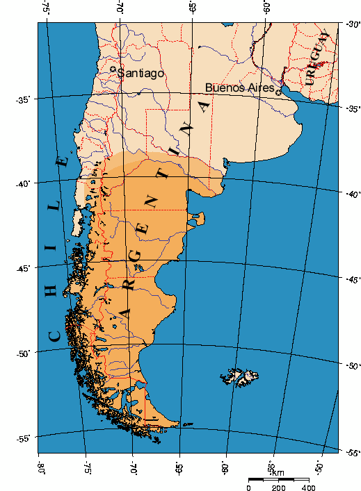
Patagonia (Spanish pronunciation: [pataˈɣonja]) is a geographical region that encompasses the southern end of South America, governed by Argentina and Chile. The region comprises the southern section of the Andes mountains, featuring lakes, fjords, temperate rainforests, and glaciers in the west, and deserts, tablelands, and steppes to the east. Patagonia is bounded by the Pacific Ocean on the west, the Atlantic Ocean to the east, and many bodies of water that connect them, including the Strait of Magellan, the Beagle Channel, and the Drake Passage to the south.

The northern limit of the region is not precisely defined. The Colorado and Barrancas rivers, which run from the Andes to the Atlantic, are commonly considered the northern limit of Argentine Patagonia. On this basis, the extent of Patagonia could be defined as the provinces of Neuquén, Río Negro, Chubut and Santa Cruz, along with Patagones Partido in the far south of Buenos Aires Province. Most geographers and historians locate the northern limit of Chilean Patagonia at the Huincul Fault in the Araucanía Region, extending across the Los Lagos Region, Magallanes Region and Aysén Region.

Adapted from Wikipedia: Patagonia (CC BY-SA 4.0).

Feature class
Geoarea
Mapped extent
41,302 km²
Size rank
#86 of 231 landforms
Region
South America
Countries
Argentina, Chile
Coordinates
-51.5874°, -75.1846°
Summits:
Monte Fitz Roy (3,375 m), Torres del Paine (2,500 m), Monte Tronador (3,554 m)
Ranges:
Cuchilla Grande (South America), Jones Mountains (Antarctica)
Settlements:
Puerto Natales (226 km), Punta Arenas (419 km), Coihaique (537 km)

View on the live map

More about Patagonia

Physical geography

Argentine Patagonia is for the most part a region of steppe-like plains, rising in a succession of 13 abrupt terraces about 100 m (330 ft) at a time, and covered with an enormous bed of shingle almost bare of vegetation. In the hollows of the plains are ponds or lakes of fresh and brackish water. Towards Chilean territory, the shingle gives way to porphyry, granite, and basalt lavas, and animal life becomes more abundant. Vegetation is more luxuriant, consisting principally of southern beech and conifers. The high rainfall against the western Andes (Wet Andes) and the low sea-surface temperatures offshore give rise to cold and humid air masses, contributing to the ice fields and glaciers, the largest ice fields in the Southern Hemisphere outside of Antarctica.

Climate

Patagonia's climate is mostly cool and dry year round. The east coast is warmer than the west, especially in summer, as a branch of the southern equatorial current reaches its shores, whereas the west coast is washed by a cold current. However, winters are colder on the inland plateaus east of the slopes and further down the coast on the southeast end of the Patagonian region.

History

Human habitation of the region dates back thousands of years, with some early archaeological findings in the area dated to at least the 13th millennium BC, although later dates around the 10th millennium BC are more securely recognized. Evidence exists of human activity at Monte Verde in Llanquihue Province, Chile, dated to around 14,500 years Before Present (~12,500 BC). The glacial-period ice fields and subsequent large meltwater streams would have made settlement difficult at that time.

The region seems to have been inhabited continuously since 10,000 BC by various cultures and alternating waves of migration, the details of which are as yet poorly understood.

Economy

The area's principal economic activities have been mining, whaling, livestock (notably sheep throughout) agriculture (wheat and fruit production near the Andes towards the north), and oil after its discovery near Comodoro Rivadavia in 1907.

In the western forest-covered Patagonian Andes and archipelagoes, wood logging has historically been an important part of the economy; it impelled the colonization of the areas of the Nahuel Huapi and Lácar lakes in Argentina and Guaitecas Archipelago in Chile.

Sheep farming introduced in the late 19th century has been a principal economic activity. After reaching its heights during the First World War, the decline in world wool prices affected sheep farming in Argentina.

Sections adapted from Wikipedia: Patagonia (CC BY-SA 4.0).

Southern Patagonian Ice Field
Image via Wikimedia Commons (author and licence on the file page).

Southern Patagonian Ice Field

Glaciated areas · 14,163 km²

Southern Patagonian Ice Field is a glaciated areas in Chile and Argentina, covering an estimated 14,163 km². About 85% of the ice lies in Chile, and the rest in Argentina. It is the 11th-largest of the 68 glaciers and ice fields with a mapped extent in YearMaps.

The Southern Patagonian Ice Field (Spanish: Campo de Hielo Patagónico Sur), located at the Southern Patagonic Andes between Chile and Argentina, is the world's second largest contiguous extrapolar ice field. It is the bigger of two remnant parts of the Patagonian Ice Sheet, which covered all of southern Chile during the last glacial period, locally called the Llanquihue glaciation.

Adapted from Wikipedia: Southern Patagonian Ice Field (CC BY-SA 4.0).

Feature class
Glaciated areas
Mapped extent
14,163 km²
Size rank
#11 of 68 glaciers and ice fields
Countries
Chile, Argentina
Coordinates
-48.5437°, -73.4671°
Summits:
Monte Fitz Roy (3,375 m), Torres del Paine (2,500 m), Monte Tronador (3,554 m)
Ranges:
Cuchilla Grande (South America), Serra Geral (South America)
Settlements:
Puerto Natales (241 km), Punta Arenas (430 km), Coihaique (467 km)

View on the live map

More about Southern Patagonian Ice Field

Geography

The Southern Patagonian Ice Field extends from parallels 48° 15′ S to 51° 30′ S for approximately 350 kilometres (220 mi), and has an approximate area of 16,480 km2 (6,360 sq mi), of which 14,200 km2 (5,500 sq mi) belong to Chile and 2,600 km2 (1,000 sq mi) belong to Argentina.

The ice mass feeds dozens of glaciers in the area, among which are the Upsala (765 km2 or 295 sq mi), Viedma (978 km2 or 378 sq mi) and Perito Moreno (258 km2 or 100 sq mi) in the Los Glaciares National Park in Argentina, and the Pío XI Glacier or Bruggen Glacier (1,265 km2 or 488 sq mi, the largest in area and longest in the Southern Hemisphere outside of Antarctica), O'Higgins (820 km2 or 320 sq mi), Grey (270 km2 or 100 sq mi) and Tyndall (331 km2 or 128 sq mi) in Chile.

History

Thorough explorations include the expeditions of Federico Reichert (1913–1914), Alberto de Agostini (1931), and Harold William Tilman and Jorge Quinteros (1955–1956), as well as Eric Shipton (1960–61). The first (North-South) crossing of the field was accomplished in 1998 by Pablo Besser, Mauricio Rojas, José Montt, and Rodrigo Fica. Nevertheless, some areas of the field remain largely unexplored.

From the air, initial exploration was conducted in 1928–29 by Gunther Plüschow after whom a glacier is named. From April 1944 to April 1945, the United States Army Air Forces conducted an aerial survey using the Trimetrogon method at the request of the Chilean government.

Sections adapted from Wikipedia: Southern Patagonian Ice Field (CC BY-SA 4.0).

Southern Patagonian Ice Field: Key Facts

Key facts about Southern Patagonian Ice Field
Mountain rangePatagonian Andes

Facts from Wikidata Q1031467 (CC0).

Northern Patagonian Ice Field
Image via Wikimedia Commons (author and licence on the file page).

Northern Patagonian Ice Field

Glaciated areas · 4,483 km²

Northern Patagonian Ice Field is a glaciated areas in Chile, covering an estimated 4,483 km². It is the 24th-largest of the 68 glaciers and ice fields with a mapped extent in YearMaps.

The Northern Patagonian Ice Field, located in southern Chile, is the smaller of two remnant parts in which the Patagonian Ice Sheet in the Andes Mountains of southern South America can be divided. It is completely contained within the boundaries of Laguna San Rafael National Park.

Adapted from Wikipedia: Northern Patagonian Ice Field (CC BY-SA 4.0).

Feature class
Glaciated areas
Mapped extent
4,483 km²
Size rank
#24 of 68 glaciers and ice fields
Coordinates
-46.8562°, -73.4641°
Summits:
Monte Fitz Roy (3,375 m), Torres del Paine (2,500 m), Monte Tronador (3,554 m)
Ranges:
Cuchilla Grande (South America), Serra Geral (South America)
Settlements:
Coihaique (179 km), Comodoro Rivadavia (470 km), Esquel (471 km)

View on the live map

More about Northern Patagonian Ice Field

Description

The Northern Patagonian Ice Field is a vestige of the Patagonian Ice Sheet, an extensive ice sheet that covered all of Chilean Patagonia and the westernmost parts of Argentine Patagonia during the Quaternary glaciations. Today, with its glaciers largely in retreat and only an area of 4,200 km2 (1,600 sq mi), it is still the second largest continuous mass of ice outside of the polar regions. Its survival depends on its elevation (1,100 to 1,500 m (3,600 to 4,900 ft)), favorable terrain and a cool, moist, oceanic climate. The ice field has 28 exit glaciers, the largest two — San Quintin and San Rafael — nearly reach sea level to the west at the Pacific Ocean. Smaller exit glaciers, like San Valentín and Nef, feed numerous rivers and glacially carved lakes to the east.

Sections adapted from Wikipedia: Northern Patagonian Ice Field (CC BY-SA 4.0).

Northern Patagonian Ice Field: Key Facts

Key facts about Northern Patagonian Ice Field
Mountain rangePatagonian Andes

Facts from Wikidata Q1031462 (CC0).

More on Chile

Quick Answers

What is the largest landform in Chile?
South America, at 17.91M km². Altiplano is second at 339,339 km². Rankings cover the mountain ranges, deserts and other landforms indexed in YearMaps.
How many mountain ranges, deserts and other landforms are there in Chile?
YearMaps lists 8 mountain ranges, deserts and other landforms for Chile. This is the number mapped in the atlas, not an official national count.