Skip to content
YearMaps
Chile · Islands

Largest Islands of Chile

Islas Juan Fernandez is the largest of the 5 islands recorded for Chile, at 13,230 km², ahead of Tierra del Fuego at 2,548 km². The full list follows.

How this list is built: Ranked by mapped area. An island divided between countries is listed under each, with the area of the whole island. It covers the islands indexed in YearMaps, drawn from open geospatial data, and is not an exhaustive national register.

Islands Listed
5
Top Ranked
13,230 km²
Islas Juan Fernandez
Second
2,548 km²
Tierra del Fuego
Profiled Below
4
Photo, encyclopedia text and figures
Largest Islands of Chile
#NameArea
1Islas Juan Fernandez13,230 km²
2Tierra del Fuego2,548 km²
3Isla de Chiloé983 km²
4Islas Desventuradas875 km²
5Isla Wellington348 km²

The Islands of Chile in Detail

The 4 islands above that have an encyclopedia article, in the same order, each with its photograph, figures and the places around it.

Tierra del Fuego
Image via Wikimedia Commons (author and licence on the file page).

Tierra del Fuego

Island · 2,548 km²

Tierra del Fuego is an island in South America, covering an estimated 2,548 km². It extends across Chile and Argentina.

Isla Grande de Tierra del Fuego (Spanish for 'Great Island of Land of Fire'), also formerly called Isla de Xátiva, is an island near the southern tip of South America from which it is separated by the Strait of Magellan. The western portion (61.43%) of the island (27,294 km2 (10,538.3 sq mi)) is in Chile (Province of Tierra del Fuego and Antártica Chilena Province), while the eastern portion (38.57%, or 20,698 km2 (7,991.5 sq mi)) is in Argentina (Tierra del Fuego Province). It forms the major landmass in an extended archipelago (island group) also called Tierra del Fuego.

The island has an area of 47,992 km2 (18,530 sq mi), making it the largest island in South America and the 29th largest island in the world. Its two biggest towns are Ushuaia and Río Grande, both in Argentina. Other towns are Tolhuin, Porvenir, Camerón, and Cerro Sombrero. The Argentine side, Tierra del Fuego Province, has 190,641 inhabitants (2022), whereas the Chilean side has only 6,656 (2012), almost all located in the Tierra del Fuego Province.

Its highest point is unofficially named Monte Shipton (2,580 m (8,465 ft)), in Chile.

Adapted from Wikipedia: Isla Grande de Tierra del Fuego (CC BY-SA 4.0).

Feature class
Island
Mapped extent
2,548 km²
Size rank
#238 of 445 islands
Region
South America
Countries
Chile, Argentina
Coordinates
-54.5913°, -71.9332°
Summits:
Torres del Paine (2,500 m), Monte Fitz Roy (3,375 m), Monte Tronador (3,554 m)
Ranges:
Jones Mountains (Antarctica), Cuchilla Grande (South America)
Settlements:
Punta Arenas (206 km), Puerto Natales (387 km), Coihaique (1,055 km)

View on the live map

More about Tierra del Fuego

Geography

Tierra del Fuego is bounded on the east by the South Atlantic, on the north by the Magellan Straits and on the south and west by a series of fjords and channels linked to the Pacific Ocean. One of the few prominent features of the northeast shore is San Sebastián Bay. To the south the island is bounded by the Beagle Channel, south of which lie a series of islands included in Chilean territory. To the west the island has two major inlets, Inútil Bay and Almirantazgo Fjord. The latter lies along the Magallanes–Fagnano Fault and is a continuation of the Cami Lake depression in southern Tierra del Fuego.

History

The earliest human settlement occurred more than 10,000 years ago, as people migrated from the mainland, perhaps under pressure from competitors. The Yaghan people were some of the earliest known humans settling in Tierra del Fuego. Certain archeological sites at locations such as Navarino Island, within the islands of Tierra del Fuego, have yielded artifacts and evidence of their culture from the Megalithic era.

The name Tierra del Fuego derives from Portuguese explorer Ferdinand Magellan, who was the first European to visit these lands in 1520, on his voyage to the Philippines from Spain. He believed he was seeing the many fires (fuego in Spanish) of the Amerindians, which were visible from the sea and that the "Indians" were waiting in the forests to ambush his armada.

Climate

The region has a subpolar oceanic climate and a mild tundra climate (Köppen climate classification Cfc and ET) with short, cool summers with a mean at around 10 °C (50 °F) and long, cool and wet winters with a mean at around 0 °C (32 °F). The northeast is characterized by strong winds and little precipitation, while in the south and west it is very windy, foggy, and wet most of the year, with precipitation levels averaging 3,000 millimetres (120 in) a year. The permanent snow line begins at 700 metres (2,300 ft). Places in the world with comparable climates are the Aleutian Islands, Iceland, Kuril Islands, Campbell Island, the Kerguelen Islands, the Scottish Highlands, and coastal areas of Norway.

Economy

The main industries are oil, natural gas, sheep farming and ecotourism. On the Argentine side, several electronics companies have been established. Ushuaia is home to the small brewing company Cervecería Fueguina, which produces three beers under the Beagle brand name.

The fishing industry in Tierra del Fuego centers around the export of spider crabs, mussels, and other mollusks. Krill are abundant in nearby waters, but have not yet been successfully harvested. The agricultural sector in Tierra del Fuego is underdeveloped.

Sections adapted from Wikipedia: Isla Grande de Tierra del Fuego (CC BY-SA 4.0).

Tierra del Fuego: Key Facts

Key facts about Tierra del Fuego
Area47,992 km²
Population200,000
Highest pointMonte Shipton
Surrounded byAtlantic Ocean

Facts from Wikidata Q1674067 (CC0).

Isla de Chiloé
Image via Wikimedia Commons (author and licence on the file page).

Isla de Chiloé

Island · 983 km²

Isla de Chiloé is an island in South America, covering an estimated 983 km².

Chiloé Island (Spanish: Isla de Chiloé, pronounced [tʃiloˈe], locally [ʃiloˈe]), also known as Greater Island of Chiloé (Isla Grande de Chiloé), is the largest island of the Chiloé Archipelago off the west coast of Chile, in the Pacific Ocean. The island is located in southern Chile, in the Los Lagos Region.

The island is roughly rectangular. Its southwestern half is a wilderness of contiguous forests and swamps. Mountains form a belt running from the northwestern to the southeastern corners of the island. Cordillera del Piuchén make up the northern mountains and the more subdued Cordillera de Pirulil gathers the southern mountains. The landscape of the northeastern sectors of Chiloé Island is dominated by rolling hills with a mosaic of pastures, forests and cultivated fields. While the western shores are rocky and relatively straight, the eastern and northern shores contain many inlets, bays and peninsulas, and it is here where all towns and cities lie.

Geographically, the bulk of the island is a continuation of the Chilean Coast Range, with the Sea of Chiloé being a submerged portion of the Chilean Central Valley.

Adapted from Wikipedia: Chiloé Island (CC BY-SA 4.0).

Feature class
Island
Mapped extent
983 km²
Size rank
#297 of 445 islands
Region
South America
Coordinates
-41.8901°, -74.0160°
Summits:
Monte Tronador (3,554 m), Monte Fitz Roy (3,375 m), Torres del Paine (2,500 m)
Ranges:
Cuchilla Grande (South America), Serra Geral (South America)
Settlements:
Ancud (16 km), Castro (69 km), Puerto Montt (102 km)

View on the live map

More about Isla de Chiloé

Geography

With an area of 8,394 square kilometres (3,241 mi2), Chiloé Island is the second largest island in Chile (after the Isla Grande de Tierra del Fuego), the largest island completely within Chile, and the fourth largest in South America. It is separated from the Chilean mainland by the Chacao Strait (Canal Chacao) to the north, and by the Gulf of Ancud (Golfo de Ancud) and the Gulf of Corcovado (Golfo Corcovado) to the east; the Pacific Ocean lies to the west, and the Chonos Archipelago lies to the south, across the Boca del Guafo. The island is 190 km (118 mi) from north to south, and averages 55–65 km (34–40 mi) wide.

History

Chiloé has been described by Renato Cárdenas, historian at the Chilean National Library, as "a distinct enclave, linked more to the sea than the continent, a fragile society with a strong sense of solidarity and a deep territorial attachment".

Chiloé's history began with the arrival of its first human inhabitants more than 7,000 years ago. Spread along the coast of Chiloé are a number of middens - ancient dumps for domestic waste, containing mollusc shells, stone tools and bonfire remains. All of these remains indicate the presence of nomadic groups dedicated to the collection of marine creatures (clams, mussels and Choromytilus chorus, among others) and to hunting and fishing.

Climate

Chiloé runs from 41º47'S to 43º26'S, and has a humid, cool temperate climate. The western side of the island is rainy and wild, home to the Valdivian temperate rain forests, one of the world's few temperate rain forests. Chiloé National Park (Parque Nacional de Chiloé) is located on the island's western shore and Tantauco Park (Parque Tantauco), a private natural reserve created and owned by Chilean business magnate and former President of Chile Sebastián Piñera, is located on the island's southern shore. Both include parts of the coastal range. The eastern shore, in the rain shadow of the interior mountains, is warmer and drier.

Sections adapted from Wikipedia: Chiloé Island (CC BY-SA 4.0).

Isla de Chiloé: Key Facts

Key facts about Isla de Chiloé
Area8,394 km²
Population150,000
Surrounded byGulf of Ancud

Facts from Wikidata Q504449 (CC0).

Visiting Isla de Chiloé

Chiloé Island (Spanish: Isla de Chiloé) is in Southern Chile, off-shore from the northern Patagonian regions of Los Lagos and Aysén.

The best time to visit is during the summer (December to March).

Travel notes adapted from Wikivoyage: Chiloé Island (CC BY-SA 4.0).

Islas Desventuradas
Image via Wikimedia Commons (author and licence on the file page).

Islas Desventuradas

Island group · 875 km²

Islas Desventuradas is an island group in Seven seas (open ocean), covering an estimated 875 km².

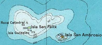
The Desventuradas Islands (Spanish: Islas Desventuradas, IPA: [ˈislas ðesβentuˈɾaðas], "Unfortunate Islands" or Islas de los Desventurados, "Islands of the Unfortunate Ones") is a group of four small oceanic islands located 850 kilometres (530 mi) off the coast of Chile, northwest of Santiago in the Pacific Ocean. They are considered part of Insular Chile.

Due to their isolation and difficulty of access there are no civilian settlements on these islands, but a detachment of the Chilean Navy is stationed on Isla San Félix, which also hosts the 2,000-metre (6,600 ft) Isla San Felix Airport.

Adapted from Wikipedia: Desventuradas Islands (CC BY-SA 4.0).

Feature class
Island group
Mapped extent
875 km²
Size rank
#307 of 445 islands
Region
Seven seas (open ocean)
Coordinates
-26.3120°, -79.9450°
Summits:
Cerro de Los Inocentes (1,650 m), Nevado Ojos del Salado (6,880 m), Cerro Aconcagua (6,959 m)
Ranges:
Cuchilla Grande (South America), Serra Geral (South America)
Settlements:
Coquimbo (935 km), Vallenar (940 km), La Serena (941 km)

View on the live map

More about Islas Desventuradas

History

No signs of prehistoric human activity by Polynesians or Indigenous peoples of the Americas have ever been found on the islands, or on the neighboring Juan Fernández Islands. Michael Levinson's 1973 book The Settlement of Polynesia states, "the Juan Fernández Islands and San Felix and San Ambrosio were apparently unoccupied in pre-Columbian times and were not discovered by the Spanish until between 1563 and 1574. There is no evidence available to suggest that they were visited for fishing or other reasons by Amerindians before this."

The islands were possibly discovered by Ferdinand Magellan as early as 1521. The first confirmed sighting was by Juan Fernández on 6 November 1574 while voyaging from Callao to Valparaíso.

Ecology

Vegetation of the larger islands is a miniature mosaic of matorral, barren rock, various sizes of trees, and shrubs mixed with ferns and perennial herbs. Sonchus laceratus is an endemic shrub species. The large islands, San Félix and San Ambrosio, are home to a critical WWF recognized temperate forest biome.

The marine fauna shares close affinities with the south Pacific and the central Pacific, more so than with the nearing South America. This is partly due to the Humboldt Current, which helps create a powerful biogeographic barrier between these islands and South America.

There are no permanent sources of fresh water on any of the islands. Vertebrates inhabiting both of the largest islands are limited to birds.

Sections adapted from Wikipedia: Desventuradas Islands (CC BY-SA 4.0).

Islas Desventuradas: Key Facts

Key facts about Islas Desventuradas
Area5.4 km²
Population0 (2019)
Surrounded byPacific Ocean

Facts from Wikidata Q1160526 (CC0).

Isla Wellington
Image via Wikimedia Commons (author and licence on the file page).

Isla Wellington

Island · 348 km²

Isla Wellington is an island in South America, covering an estimated 348 km².

Wellington Island is an island west of Southern Patagonian Ice Field, Chile. It has an area of 5,556 km2 and most of the island forms part of Bernardo O'Higgins National Park. It is home to the last Kawésqar people, living in the village of Puerto Edén, the only inhabited place on the island.

Adapted from Wikipedia: Wellington Island (CC BY-SA 4.0).

Feature class
Island
Mapped extent
348 km²
Size rank
#350 of 445 islands
Region
South America
Coordinates
-49.3218°, -75.3974°
Summits:
Monte Fitz Roy (3,375 m), Torres del Paine (2,500 m), Monte Tronador (3,554 m)
Ranges:
Cuchilla Grande (South America), Jones Mountains (Antarctica)
Settlements:
Puerto Natales (336 km), Coihaique (486 km), Río Gallegos (507 km)

View on the live map

More about Isla Wellington

Isla Wellington: Key Facts

Key facts about Isla Wellington
Area5,556 km²
Population250
Surrounded byPacific Ocean

Facts from Wikidata Q1048284 (CC0).

More on Chile

Quick Answers

What is the largest island in Chile?
Islas Juan Fernandez, at 13,230 km². Tierra del Fuego is second at 2,548 km². Rankings cover the islands indexed in YearMaps.
How many islands are there in Chile?
YearMaps lists 5 islands for Chile. This is the number mapped in the atlas, not an official national count.