Baffin Island
Island · 562,182 km²
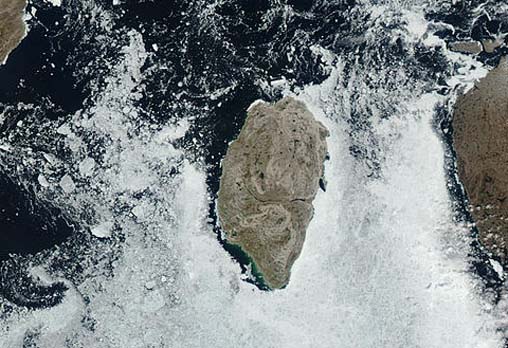
Baffin Island is an island in North America (Arctic Archipelago), covering an estimated 562,182 km². It is the 17th-largest of the 445 islands with a mapped extent in YearMaps.
Baffin Island in the Canadian territory of Nunavut, is the largest island in Canada, the second-largest island in the Americas (behind Greenland), and the fifth-largest island in the world. As of July 31, 2026 its area is 507,204.95 square kilometres (195,832.93 square miles) with a population density of 0.026/km2 (0.067/sq mi); the population was 13,039 according to the 2021 Canadian census; and it is located at 68°N 70°W. Iqaluit, the capital of Nunavut, is located on Frobisher Bay on the southern tip of the island. It has been inhabited for at least 3,000 years and possibly much longer; evidence of the earliest known circumpolar peoples is evident on the islands.
Adapted from Wikipedia: Baffin Island (CC BY-SA 4.0).
- Feature class
- Island
- Mapped extent
- 562,182 km²
- Size rank
- #17 of 445 islands
- Region
- North America
- Subregion
- Arctic Archipelago
- Coordinates
- 71.7398°, -84.0607°
- Summits:
- Mount Odin (2,143 m), Mount Caubvick (1,652 m), Mount Forel (3,360 m)
- Ranges:
- Ogilvie Mountains (North America), Cassiar Mountains (North America)
- Settlements:
- Fort McMurray (2,089 km), Prince Albert (2,313 km), Saskatoon (2,441 km)
More about Baffin Island
Geography
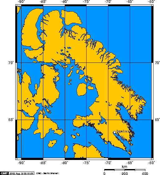
Iqaluit, the capital of Nunavut, is located on the southeastern coast. Until 1987, the town was called Frobisher Bay, after the English name for Frobisher Bay on which it is located, named for Martin Frobisher. That year, the community voted to restore the Inuktitut name.
To the south lies Hudson Strait, separating Baffin Island from mainland Quebec. South of the western end of the island is Fury and Hecla Strait, which separates the island from the Melville Peninsula on the mainland. To the east are Davis Strait and Baffin Bay, with Greenland to the east. Prince Regent Inlet and the Gulf of Boothia separate the island from Somerset Island and the Boothia Peninsula, respectively. Foxe Basin, with Prince Charles Island, is in the southwest.
History
Baffin Island has been inhabited for over 3,000 years, first by the pre-Dorset, followed by the Dorset, and then by the Thule people, ancestors of the Inuit, who have lived on the island for the last thousand years. The Thule people genetically and culturally completely replaced the Dorset people some time after 1300 CE.
They sailed away from land; then to the Vestribygd and to Bjarneyjar (the Bear Islands). Thence they sailed away from Bjarneyjar with northerly winds. They were out at sea two half-days. Then they came to land, and rowed along it in boats, and explored it, and found there flat stones, many and so great that two men might well lie on them stretched on their backs with heel to heel. Polar-foxes were there in abundance.
Climate
Baffin Island lies in the path of a generally northerly airflow all year round, so, like much of northeastern Canada, it has an extremely cold climate. This brings very long, cold winters and foggy, cloudy summers, which have helped to add to the remoteness of the island. Spring thaw arrives much later than normal for a position straddling the Arctic Circle: around early June at Iqaluit in the south-east but around early- to mid-July on the north coast where glaciers run right down to sea level. Snow, even heavy snow, can occur at any time of the year, although it is least likely in July and early August. Average annual temperatures at Iqaluit are around −9.5 °C (14.9 °F), compared with around 5 °C (41 °F) in Reykjavík, which is at a similar latitude.
Demographics and administration
Baffin Island is part of the Qikiqtaaluk Region. The population of Baffin Island at the 2021 Canadian census was 13,039, giving a population density of 0.03/km2 (0.07/sq mi). The population accounts for 67.37 per cent of the 19,355 people in the Qikiqtaaluk Region, 56.51 per cent of the population of the Arctic Archipelago, and 35.38 per cent of the population of Nunavut.
As of the 2016 Canadian census the majority, 74.06 per cent, were Indigenous peoples and 25.83 per cent were non-Indigenous.
Sections adapted from Wikipedia: Baffin Island (CC BY-SA 4.0).
Baffin Island: Key Facts
| Area | 507,451 km² |
|---|---|
| Population | 13,148 (2016) |
| Highest point | Mount Odin |
| Surrounded by | Arctic Ocean |
Facts from Wikidata Q81178 (CC0).
Visiting Baffin Island
Baffin Island (Inuktitut: ᕿᑭᖅᑖᓗᒃ, Qikiqtaaluk) is an island in Nunavut, Canada. It's the world's fifth largest island. It is larger in area than Spain, but has a population of only 13,000 people (2016). It lies to the west of Greenland, across the Baffin Bay.
Travel notes adapted from Wikivoyage: Baffin Island (CC BY-SA 4.0).