Skip to content
YearMaps
Canada · Landforms

Mountain Ranges, Deserts and Landforms of Canada

North America is the largest of the 57 mountain ranges, deserts and other landforms recorded for Canada, at 27.05M km², ahead of Canadian Shield at 2.15M km². The full list follows.

How this list is built: Ranked by mapped area. Covers mountain ranges, deserts, plateaus, named glaciers, plains, basins, peninsulas and capes. One that crosses a border is listed under every country it lies in, with the area of the whole feature. It covers the mountain ranges, deserts and other landforms indexed in YearMaps, drawn from open geospatial data, and is not an exhaustive national register.

Landforms Listed
57
Top Ranked
27.05M km²
North America
Second
2.15M km²
Canadian Shield
Profiled Below
24
Photo, encyclopedia text and figures
Mountain Ranges, Deserts and Landforms of Canada
#NameArea
1North America27.05M km²
2Canadian Shield2.15M km²
3Central Lowland2.05M km²
4Great Plains1.97M km²
5Rocky Mountains1.08M km²
6APPALACHIAN Mountains850,356 km²
7MACKENZIE Mountains309,422 km²
8Coast Mountains214,489 km²
9Cascade Range140,770 km²
10Fraser Plateau135,860 km²
11Cassiar Mountains121,459 km²
12COLUMBIA Mountains93,873 km²
13Yukon Plateau91,311 km²
14Barren Grounds64,951 km²
15Birch Mountains43,834 km²
16Kluane Ice Cap34,826 km²
17Boothia Peninsula32,045 km²
18Great Lakes31,369 km²
19Caribou Mountains27,317 km²
20North Ellesmere Ice Cap25,362 km²
21Agassiz Ice Cap22,514 km²
22Prince of Wales Icefield20,851 km²
23Meta Incognita Peninsula17,389 km²
24Ogilvie Mountains15,686 km²
25Devon Ice Cap15,427 km²
26Foxe Peninsula13,188 km²
27Müller Ice Cap9,087 km²
28Penny Ice Cap7,838 km²
29Horn Plat7,309 km²
30Stikine Icecap6,670 km²
31Manson Icefield6,306 km²
32Barnes Ice Cap6,100 km²
33Juneau Icefield5,407 km²
34Brooks Range3,380 km²
35Steacie Ice Cap3,216 km²
36Sydkap Ice Cap3,087 km²
37Monarch Icefield1,288 km²
38TORNGAT Mountains1,049 km²
39Cambria Icefiled1,045 km²
40CHUGACH Mountains936 km²
41Homathko Icefield932 km²
42Columbia Icefield756 km²
43SELWYN Mountains732 km²
44Lyell Icefield561 km²
45Pemberton Icefield463 km²
46Mount Brown Icefield415 km²
47PéNinsule D’Ungava339 km²
48Les Laurentides311 km²
49Hooker Icefield301 km²
50Hang Ten Icefield215 km²
51Pén. de Gaspé207 km²
52Plateau Icefield164 km²
53Braithwaite Icefield162 km²
54Albert Icefield138 km²
55Clachnacudainn Icefield53 km²
56Canadian Shield12 km²
57Cumberland Peninsula—

The Landforms of Canada in Detail

The 24 mountain ranges, deserts and other landforms above that have an encyclopedia article, in the same order, each with its photograph, figures and the places around it.

Rocky Mountains
Image via Wikimedia Commons (author and licence on the file page).

Rocky Mountains

Range/mtn · 1.08M km²

Rocky Mountains is a range/mtn in North America, covering an estimated 1.08M km². It extends across the United States and Canada. It is the largest of the 216 mountain ranges with a mapped extent in YearMaps.

The Rocky Mountains, also known as the Rockies, are a major mountain range and the largest mountain system in North America. The Rocky Mountains stretch 3,000 mi (4,800 km) in a straight-line distance from the northernmost part of Western Canada, to New Mexico in the Southwestern United States. Depending on differing definitions between Canada and the U.S., its northern terminus is located either in northern British Columbia's Terminal Range south of the Liard River and east of the Trench, or in the northeastern foothills of the Brooks Range/British Mountains that face the Beaufort Sea coasts between the Canning River and the Firth River across the Alaska–Yukon border. Its southernmost point is near the Albuquerque metropolitan area, adjacent to the Rio Grande rift, and north of the Sandia–Manzano Mountain Range, also near Santa Fe, New Mexico. Being the easternmost portion of the North American Cordillera, the Rockies are distinct from the tectonically younger Cascade Range and Sierra Nevada, which both lie farther to its west.

Adapted from Wikipedia: Rocky Mountains (CC BY-SA 4.0).

Feature class
Range/mtn
Mapped extent
1.08M km²
Size rank
#1 of 216 mountain ranges
Region
North America
Countries
United States, Canada
Coordinates
42.2572°, -108.8156°
Summits:
Mount Robson (3,954 m), Mount Sir Sandford (3,519 m), Ulysses Mountain (3,024 m)
Adjacent ranges:
Coast Mountains (North America), Cascade Range (North America)
Settlements:
Grand Prairie (138 km), Prince George (180 km), Kamloops (388 km)

View on the live map

More about Rocky Mountains

Geography

The Rocky Mountains are the easternmost portion of the expansive North American Cordillera. They are often defined as a network stretching from the Liard River in British Columbia south to the headwaters of the Pecos River, a tributary of the Rio Grande, in New Mexico. The Rockies vary in width from 110 to 480 kilometers (70 to 300 miles). The greater Rocky Mountain system functions as a collective network of dozens of distinct subranges divided by high basins and wide rolling tablelands. The Rocky Mountains contain the highest peaks in central North America. The range's highest peak is Mount Elbert in Colorado at 4,401 meters (14,440 feet) above sea level. Mount Robson in British Columbia, at 3,954 m (12,972 ft), is the highest peak in the Canadian Rockies.

Geology

The rocks in the Rocky Mountains were formed before the mountains were raised by tectonic forces. The oldest rock is Precambrian metamorphic rock that forms the core of the North American continent. There is also Precambrian sedimentary argillite, dating back to 1.7 billion years ago. During the Paleozoic, western North America lay underneath a shallow sea, which deposited many kilometers of limestone and dolomite.

In the southern Rockies, near present-day Colorado, these ancestral rocks were disturbed by mountain building approximately 300 million years ago, during the Pennsylvanian. This mountain-building produced the Ancestral Rocky Mountains. They consisted largely of Precambrian metamorphic rock forced upward through layers of the limestone laid down in the shallow sea.

Ecology and climate

There are a wide range of environmental factors in the Rocky Mountains. The Rockies range in latitude between the Liard River in British Columbia (at 59° N) and the Rio Grande in New Mexico (at 35° N). Prairie occurs at or below 550 meters (1,800 ft), while the highest peak in the range is Mount Elbert at 4,400 meters (14,440 ft). Precipitation ranges from 250 millimeters (10 in) per year in the southern valleys to 1,500 millimeters (60 in) per year locally in the northern peaks. Average January temperatures can range from −7 °C (20 °F) in Prince George, British Columbia, to 6 °C (43 °F) in Trinidad, Colorado. Therefore, there is no single monolithic ecosystem for the entire Rocky Mountain Range.

Instead, ecologists divide the Rockies into a number of biotic zones.

History

Since the last great ice age, the Rocky Mountains were home first to indigenous peoples including the Apache, Arapaho, Bannock, Blackfoot, Cheyenne, Coeur d'Alene, Kalispel, Crow Nation, Flathead, Shoshone, Sioux, Ute, Kutenai (Ktunaxa in Canada), Sekani, Dunne-za, and others. Paleo-Indians hunted the now-extinct mammoth and ancient bison (an animal 20% larger than modern bison) in the foothills and valleys of the mountains.

Sections adapted from Wikipedia: Rocky Mountains (CC BY-SA 4.0).

Rocky Mountains: Key Facts

Key facts about Rocky Mountains
Length3,000 km
Highest pointMount Elbert
Part ofNorth American Cordillera

Facts from Wikidata Q5463 (CC0).
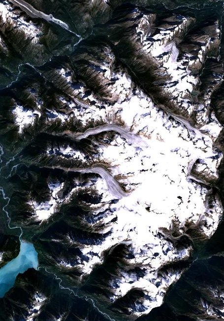
Coast Mountains
Image via Wikimedia Commons (author and licence on the file page).

Coast Mountains

Range/mtn · 214,489 km²

Coast Mountains is a range/mtn in North America, covering an estimated 214,489 km². It extends across Canada and the United States. It is the 16th-largest of the 216 mountain ranges with a mapped extent in YearMaps.

The Coast Mountain(s) (French: La chaîne Côtière) is a major mountain range in the Pacific Coast Ranges of western North America, extending from southwestern Yukon through the Alaska Panhandle and virtually all of the Coast of British Columbia south to the Fraser River. The mountain range's name derives from its proximity to the sea coast, and it is often referred to as the Coast Range. The range includes volcanic and non-volcanic mountains and the extensive ice fields of the Pacific and Boundary Ranges, and the northern end of the volcanic system known as the Cascade Volcanoes. The Coast Mountains are part of a larger mountain system called the Pacific Coast Ranges or the Pacific Mountain System, which includes the Cascade Range, the Insular Mountains, the Olympic Mountains, the Oregon Coast Range, the California Coast Ranges, the Saint Elias Mountains and the Chugach Mountains. The Coast Mountains are also part of the American Cordillera—a Spanish term for an extensive chain of mountain ranges—that consists of an almost continuous sequence of mountain ranges that form the western backbone of North America, Central America, South America and Antarctica.

Adapted from Wikipedia: Coast Mountains (CC BY-SA 4.0).

Feature class
Range/mtn
Mapped extent
214,489 km²
Size rank
#16 of 216 mountain ranges
Region
North America
Countries
Canada, United States
Coordinates
50.2747°, -123.0477°
Summits:
Mount Moresby (1,164 m), Mount Waddington (4,019 m), Ulysses Mountain (3,024 m)
Adjacent ranges:
Cassiar Mountains (North America), Cascade Range (North America)
Settlements:
Prince George (351 km), Campbell River (490 km), Courtenay (531 km)

View on the live map

More about Coast Mountains

Geography

The Coast Mountains consists of three subdivisions known as the Pacific Ranges, the Kitimat Ranges, and the Boundary Ranges. The Pacific Ranges are the southernmost subdivision of the Coast Mountains, extending from the lower stretches of the Fraser River to Bella Coola. Included in this subdivision are four of the five major coastal icecaps in the southern Coast Mountains. These are the largest temperate-latitude icecaps in the world and fuel a number of major rivers. Other than logging and a large ski resort at the resort town of Whistler, most of the land in the range is completely undeveloped. Mount Waddington, the highest mountain of the Coast Mountains, lies in the Waddington Range of the Pacific Ranges.

Geology

The Coast Mountains consist of deformed igneous and metamorphosed structurally complex pre-Tertiary rocks. These originated in diverse locations around the globe: the area is built of several different terranes of different ages with a broad range of tectonic origins. In addition, oceanic crust under the Pacific Ocean is being subducted at the southern portion of the range to form a north–south line of volcanoes called the Garibaldi Volcanic Belt, a northern extension of the Cascade Volcanoes in the northwestern United States, and contains the most explosive young volcanoes in Canada. Further north the northwesterly structural trend of the Coast Mountains lies partly in a large continental rift responsible for the creation of several volcanoes.

Sections adapted from Wikipedia: Coast Mountains (CC BY-SA 4.0).

Coast Mountains: Key Facts

Key facts about Coast Mountains
Length1,600 km
Area336,962 km²
Highest pointMount Waddington
Part ofPacific Coast Ranges

Facts from Wikidata Q920070 (CC0).

Cascade Range
Image via Wikimedia Commons (author and licence on the file page).

Cascade Range

Range/mtn · 140,770 km²

Cascade Range is a range/mtn in North America, covering an estimated 140,770 km². It extends across the United States and Canada.

The Cascade Range, or Cascades, is a major mountain range of western North America, extending from southern British Columbia through Washington and Oregon to Northern California. It includes both non-volcanic mountains, such as many of those in the North Cascades, and the notable volcanoes known as the High Cascades. The small part of the range in British Columbia is referred to as the Canadian Cascades or, locally, as the Cascade Mountains. The highest peak in the range is Mount Rainier in Washington at 14,411 feet (4,392 m).

The Cascades are part of the Pacific Ocean's Ring of Fire, the ring of volcanoes and associated mountains around the Pacific Ocean. All of the eruptions in the contiguous United States over the last 200 years have been from the Cascade Volcanoes. The two most recent were Lassen Peak from 1914 to 1921 and a major eruption of Mount St. Helens in 1980. Minor eruptions of Mount St. Helens have also occurred since, most recently from 2004 to 2008. The Cascade Range is a part of the American Cordillera, a nearly continuous chain of mountain ranges (cordillera) that form the western "backbone" of North, Central, and South America.

Adapted from Wikipedia: Cascade Range (CC BY-SA 4.0).

Feature class
Range/mtn
Mapped extent
140,770 km²
Size rank
#30 of 216 mountain ranges
Region
North America
Countries
United States, Canada
Coordinates
48.5429°, -120.9709°
Summits:
Mount Sir Sandford (3,519 m), Mount Waddington (4,019 m), Golden Hinde (2,195 m)
Adjacent ranges:
Coast Mountains (North America), Bitterroot Range (North America)
Settlements:
Kelowna (80 km), Penticton (83 km), Kamloops (92 km)

View on the live map

More about Cascade Range

Geography

The Cascades extend northward from Lassen Peak (also known as Mount Lassen) in northern California to the confluence of the Nicola and Thompson rivers in British Columbia. The Fraser River separates the Cascades from the Coast Mountains in Canada, as does the Willamette Valley from the upper portion of the Oregon Coast Range. The highest volcanoes of the Cascades, known as the High Cascades, dominate their surroundings, often standing twice the height of the nearby mountains. They often have a visual height (height above nearby crestlines) of one mile or more. The highest peaks, such as the 14,411-foot (4,392 m) Mount Rainier, dominate their surroundings for 50 to 100 miles (80 to 161 km).

Geology

The Cascade Range is made up of a band of thousands of very small, short-lived volcanoes that have built a platform of lava and volcanic debris. Rising above this volcanic platform are a few strikingly large volcanoes, like Mount Hood and Mount St. Helens, that dominate the landscape.

The Cascade volcanoes define the Pacific Northwest section of the Ring of Fire, an array of volcanoes that rim the Pacific Ocean. The Ring of Fire is also known for its frequent earthquakes. The volcanoes and earthquakes arise from a common source, namely subduction. In this case, the dense Juan de Fuca Plate plunges beneath the North American Plate at the Cascadia subduction zone.

Ecology

Forests of large, coniferous trees (western red cedars, Douglas-firs, western hemlocks, firs, pines, spruces, and others) dominate most of the Cascade Range. Cool, wet winters and warm, dry summers (largely a result of oceanic influence) favor evergreen species, whereas mild temperatures and rich soils promote fast and prolonged growth.

As a traveler passes through the Cascade Range, the climate first gets colder, then warmer and drier east of the crest. Most of the Cascades' lower and middle elevations are covered in coniferous forest; the higher altitudes have extensive meadows as well as alpine tundra and glaciers. The southern part of the Cascades are within the California Floristic Province, an area of high biodiversity.

History

Before European exploration, First Nations tribes named many peaks, including "Seekseekqua" for Mount Jefferson (Oregon), "M'laiksini Yaina" for Mount McLoughlin, "Tahoma", the Lushootseed name for Mount Rainier, and "Louwala-Clough", meaning "smoking mountain" for Mount St. Helens.

In early 1792, British navigator George Vancouver explored Puget Sound and gave English names to the high mountains he saw. Mount Baker was named for Vancouver's third lieutenant, Joseph Baker, although the first European to see it was Manuel Quimper, who named it la gran montaña del Carmelo ("Great Mount Carmel") in 1790. Mount Rainier was named after Admiral Peter Rainier.

Sections adapted from Wikipedia: Cascade Range (CC BY-SA 4.0).

Cascade Range: Key Facts

Key facts about Cascade Range
Length1,100 km
Area150,000 km²
Highest pointMount Rainier
Part ofPacific Coast Ranges

Facts from Wikidata Q4558 (CC0).

Fraser Plateau
Image via Wikimedia Commons (author and licence on the file page).

Fraser Plateau

Plateau · 135,860 km²

Fraser Plateau is a plateau in North America, covering an estimated 135,860 km².

The Fraser Plateau is an intermontane plateau. It is one of the main subdivisions of the Interior Plateau located in the Central Interior of British Columbia.

Adapted from Wikipedia: Fraser Plateau (CC BY-SA 4.0).

Feature class
Plateau
Mapped extent
135,860 km²
Size rank
#28 of 69 plateaus
Region
North America
Coordinates
53.5071°, -124.4434°
Summits:
Mount Waddington (4,019 m), Mount Robson (3,954 m), Ulysses Mountain (3,024 m)
Ranges:
Coast Mountains (North America), Cascade Range (North America)
Settlements:
Prince George (119 km), Campbell River (392 km), Grand Prairie (410 km)

View on the live map

More about Fraser Plateau

Geography

The region includes the Cariboo Plateau and Chilcotin Plateau, and the adjoining Marble, Clear and Camelsfoot Ranges on its southwestern edge.

It is defined as lying between the Bonaparte River on its southeast, beyond which is the Bonaparte or Kamloops Plateau, part of the Thompson Plateau, and by a line formed by the Dean and West Road Rivers on its northwest (the Nechako Plateau lies to the north of the West Road).

Also included in the Fraser Plateau are the Itcha and Ilgachuz Ranges and the adjoining Rainbow Range, which adjoin the Coast Mountains.

Sections adapted from Wikipedia: Fraser Plateau (CC BY-SA 4.0).

Fraser Plateau: Key Facts

Key facts about Fraser Plateau
Area34,400 km²
Elevation2,495 m
Highest pointTsitsutl Peak

Facts from Wikidata Q4492616 (CC0).

Cassiar Mountains
Image via Wikimedia Commons (author and licence on the file page).

Cassiar Mountains

Range/mtn · 121,459 km²

Cassiar Mountains is a range/mtn in North America, covering an estimated 121,459 km².

The Cassiar Mountains (French: Chaîne des Cassiars), also known as the Cassiars, are the most northerly group of the Northern Interior Mountains in the Canadian province of British Columbia and also extend slightly into the southernmost Yukon Territory. They lie north and west of the Omineca Mountains, west of the northernmost Rockies and the Rocky Mountain Trench, north of the Hazelton Mountains and east of the Boundary Ranges. They form a section of the Continental Divide, that, in this region, separates water drainage between the Arctic and Pacific Oceans. Physiographically, they are a section of the larger Yukon-Tanana Uplands province, which in turn are part of the larger Intermontane Plateaus physiographic division.

The highest mountain in the Cassiar Mountains is Thudaka Peak, at 2,748 m (9,016 ft).

Adapted from Wikipedia: Cassiar Mountains (CC BY-SA 4.0).

Feature class
Range/mtn
Mapped extent
121,459 km²
Size rank
#35 of 216 mountain ranges
Region
North America
Coordinates
59.1540°, -129.5226°
Summits:
Devils Paw (2,593 m), Mount Nirvana (2,773 m), Chilkoot Pass (1,067 m)
Adjacent ranges:
Ogilvie Mountains (North America), Wrangell Mountains (North America)
Settlements:
Juneau (298 km), Whitehorse (353 km), Prince George (714 km)

View on the live map

More about Cassiar Mountains

Cassiar Mountains: Key Facts

Key facts about Cassiar Mountains
Length480 km
Area62,900 km²
Part ofInterior Mountains

Facts from Wikidata Q2961818 (CC0).

Yukon Plateau
Image via Wikimedia Commons (author and licence on the file page).

Yukon Plateau

Plateau · 91,311 km²

Yukon Plateau is a plateau in North America, covering an estimated 91,311 km².

The Yukon Plateau is a plateau (also defined as a plain) located in the Yukon Territory, comprising much of the central and southern Yukon Territory and the far northern part of British Columbia, Canada between Tagish Lake (W) and the Cassiar Mountains (E) and north of the Nakina River.

Sub-plateaus include the Teslin Plateau and the Nisutlin Plateau, west and east of Teslin Lake, respectively.

Adapted from Wikipedia: Yukon Plateau (CC BY-SA 4.0).

Feature class
Plateau
Mapped extent
91,311 km²
Size rank
#32 of 69 plateaus
Region
North America
Coordinates
62.3666°, -137.4459°
Summits:
Mount Frank Rae (2,347 m), Mount Logan (5,959 m), Chilkoot Pass (1,067 m)
Ranges:
Ogilvie Mountains (North America), Wrangell Mountains (North America)
Settlements:
Whitehorse (223 km), Juneau (480 km), Fairbanks (576 km)

View on the live map

Barren Grounds
Image via Wikimedia Commons (author and licence on the file page).

Barren Grounds

Tundra · 64,951 km²

Barren Grounds is a tundra in North America, covering an estimated 64,951 km².

The Barren Grounds (also called Barren Lands) are a large area of tundra located in mainland Nunavut and stretching into the Northwest Territories in northern Canada. The Barren Grounds is nearly uninhabited with the exception of a few coastal villages and towns in Nunavut. The Barren Lands First Nation are located in northern Manitoba close to the Saskatchewan border.

Adapted from Wikipedia: Barren Grounds (CC BY-SA 4.0).

Feature class
Tundra
Mapped extent
64,951 km²
Size rank
#78 of 231 landforms
Region
North America
Coordinates
68.5900°, -121.8654°
Summits:
Keele Peak (2,952 m), Mount Nirvana (2,773 m), Mount Frank Rae (2,347 m)
Ranges:
Ogilvie Mountains (North America), Cassiar Mountains (North America)
Settlements:
Whitehorse (1,072 km), Fairbanks (1,199 km), Juneau (1,296 km)

View on the live map

More about Barren Grounds

Geography

The Barren Grounds are tundra, and lakes are abundant. It has several long rivers, including the Coppermine, Back, Dubawnt, Kazan, and Thelon. The land in the area is mostly flat, although there are some hills in certain areas.

Sections adapted from Wikipedia: Barren Grounds (CC BY-SA 4.0).

Boothia Peninsula
Image via Wikimedia Commons (author and licence on the file page).

Boothia Peninsula

Pen/cape · 32,045 km²

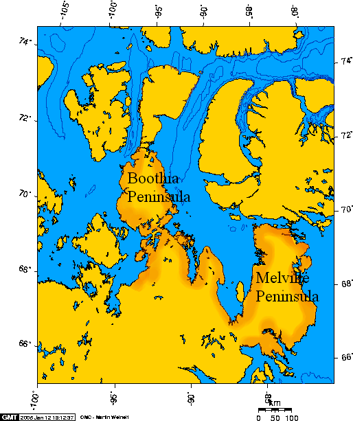
Boothia Peninsula is a pen/cape in North America (Arctic Archipelago), covering an estimated 32,045 km².

Boothia Peninsula (; formerly Boothia Felix, Inuktitut Kingngailap Nunanga) is a large peninsula in Nunavut's northern Canadian Arctic, south of Somerset Island. The northern part, Murchison Promontory, is the northernmost point of mainland Canada.

Adapted from Wikipedia: Boothia Peninsula (CC BY-SA 4.0).

Feature class
Pen/cape
Mapped extent
32,045 km²
Size rank
#93 of 231 landforms
Region
North America
Subregion
Arctic Archipelago
Coordinates
70.3360°, -94.3288°
Summits:
Mount Odin (2,143 m), Keele Peak (2,952 m), Mount Nirvana (2,773 m)
Ranges:
Ogilvie Mountains (North America), Cassiar Mountains (North America)
Settlements:
Fort McMurray (1,719 km), Prince Albert (1,990 km), Grand Prairie (2,066 km)

View on the live map

More about Boothia Peninsula

Geography

Bellot Strait (Ikirahaq) separates the peninsula from Somerset Island to the north. Babbage Bay is on the east coast, as is Abernethy Bay, just to the south. The community of Taloyoak lies in the far south and is the peninsula's only significant population centre. Paisley Bay is on the west coast, as is Wrottesley Inlet (between Paisley Bay and Bellot Strait).

Prior to the detachment of Nunavut in 1999, the Boothia Peninsula and the nearby Melville Peninsula were the only parts of mainland Canada that belonged to the District of Franklin in the then Northwest Territories. The balance of the District of Franklin was all situated within the Arctic Archipelago.

Geology and paleontology

On the peninsula there are outcrops of Early Ordovician rocks, over which Late Ordovician and Silurian rocks are identified (Middle Ordovician is not exposed). Over 1000 conodont fossils of 37 species in 28 genera were collected from these strata. Genera include Teridontus, Cordylodus, Rossodus, Variabiloconus, Semiacontiodus, Drepanoistodus, Parapanderodus, Ulrichodina, Acodus, Colaptoconus, Polyplacognathus, Pteracontiodus, Milaculum and Phosphannulus. Conodont zones are distinguished in Lower and Upper Ordovician.

Sections adapted from Wikipedia: Boothia Peninsula (CC BY-SA 4.0).

Boothia Peninsula: Key Facts

Key facts about Boothia Peninsula
Area32,300 km²

Facts from Wikidata Q893152 (CC0).

Great Lakes
Image via Wikimedia Commons (author and licence on the file page).

Great Lakes

Lake · 31,369 km²

Great Lakes is a lake in North America, covering an estimated 31,369 km². It extends across Canada and the United States.

The Great Lakes, also called the Great Lakes of North America, are a series of large interconnected freshwater lakes spanning the Canada–United States border. The five lakes are Superior, Michigan, Huron, Erie, and Ontario (though hydrologically, Michigan and Huron are a single body of water, joined at the Straits of Mackinac). The Great Lakes Waterway enables modern travel and shipping by water among the lakes. The lakes connect ultimately to the Atlantic Ocean via the Saint Lawrence River as their primary drainage outflow. The lakes are also connected to the Mississippi River basin through the Illinois Waterway.

The Great Lakes are the largest group of freshwater lakes on Earth by total area and the second-largest by total volume. They contain more than 20% of the world's surface fresh water by volume. The total surface is 94,250 square miles (244,106 km2), and the total volume (measured at the low water datum) is 5,439 cubic miles (22,671 km3), slightly less than the volume of Lake Baikal (5,666 cu mi or 23,615 km3, 22–23% of the world's surface fresh water).

Adapted from Wikipedia: Great Lakes (CC BY-SA 4.0).

Feature class
Lake
Mapped extent
31,369 km²
Size rank
#94 of 231 landforms
Region
North America
Countries
Canada, United States
Coordinates
48.2841°, -86.9007°
Summits:
Ishpatina Ridge (693 m), Mont Tremblant (968 m), Mont Yapeitso (1,128 m)
Ranges:
Black Hills (North America), Blue Ridge (North America)
Settlements:
Thunder Bay (207 km), Timmins (392 km), Sudbury (454 km)

View on the live map

More about Great Lakes

Geography

Though the five lakes lie in separate basins, they form a single, naturally interconnected body of fresh water, within the Great Lakes Basin. As a chain of lakes and rivers, they connect the east-central interior of North America to the Atlantic Ocean. From the interior to the outlet at the Saint Lawrence River, water flows from Superior to Huron and Michigan, southward to Erie, and finally northward to Lake Ontario. The lakes drain a large watershed via many rivers and contain approximately 35,000 islands. There are also several thousand smaller lakes, often called "inland lakes", within the basin.

Geology

It has been estimated that the foundational geology that created the conditions shaping the present day upper Great Lakes was laid from 1.1 to 1.2 billion years ago, when two previously fused tectonic plates split apart and created the Midcontinent Rift, which crossed the Great Lakes Tectonic Zone. A valley was formed providing a basin that eventually became modern day Lake Superior. When a second fault line, the Saint Lawrence rift, formed approximately 570 million years ago, the basis for Lakes Ontario and Erie was created, along with what would become the Saint Lawrence River.

The Great Lakes are estimated to have been formed at the end of the Last Glacial Period (the Wisconsin glaciation ended 10,000 to 12,000 years ago), when the Laurentide Ice Sheet receded.

Climate

Köppen climate classification Dfa (in southern areas) and Dfb (in northern parts) with varying influences from air masses from other regions including dry, cold Arctic systems, mild Pacific air masses from the west, and warm, wet tropical systems from the south and the Gulf of Mexico. The lakes have a moderating effect on the climate; they can also increase precipitation totals and produce lake effect snowfall.

The Great Lakes can have an effect on regional weather called lake-effect snow, which is sometimes very localized. Even late in winter, the lakes often have no icepack in the middle. The prevailing winds from the west pick up the air and moisture from the lake surface, which is slightly warmer in relation to the cold surface winds above.

Ecology

Historically, the Great Lakes, in addition to their lake ecology, were surrounded by various forest ecoregions (except in a relatively small area of southeast Lake Michigan where savanna or prairie occasionally intruded). Logging, urbanization, and agriculture uses have changed that relationship. In the early 21st century, Lake Superior's shores are 91% forested, Lake Huron 68%, Lake Ontario 49%, Lake Michigan 41%, and Lake Erie, where logging and urbanization has been most extensive, 21%. Some of these forests are second or third growth (i.e. they have been logged before, changing their composition).

Sections adapted from Wikipedia: Great Lakes (CC BY-SA 4.0).

Great Lakes: Key Facts

Key facts about Great Lakes
Area208,610 km²

Facts from Wikidata Q7347 (CC0).

Agassiz Ice Cap
Image via Wikimedia Commons (author and licence on the file page).

Agassiz Ice Cap

Glaciated areas · 22,514 km²

Agassiz Ice Cap is a glaciated areas in Canada, covering an estimated 22,514 km². It is the 8th-largest of the 68 glaciers and ice fields with a mapped extent in YearMaps.

The Agassiz Ice Cap formerly Agassiz Glacier is an ice cap on the central eastern side of Ellesmere Island, Nunavut, Canada. The Agassiz ice cap is about 21,000 km2 (8,100 sq mi) in area. It is located between the North Ellesmere ice field to the north and the Prince of Wales Icefield to the south.

Adapted from Wikipedia: Agassiz Ice Cap (CC BY-SA 4.0).

Feature class
Glaciated areas
Mapped extent
22,514 km²
Size rank
#8 of 68 glaciers and ice fields
Coordinates
80.0123°, -77.3666°
Summits:
Mount Odin (2,143 m), Newtontoppen (1,713 m), Gunnbjørn Fjeld (3,694 m)
Ranges:
Brooks Range (North America), Ogilvie Mountains (North America)
Settlements:
Reykjavík (2,411 km), Tromsø (2,620 km), Fairbanks (2,627 km)

View on the live map

More about Agassiz Ice Cap

Agassiz Ice Cap: Key Facts

Key facts about Agassiz Ice Cap
Mountain rangeArctic Cordillera

Facts from Wikidata Q390766 (CC0).

Meta Incognita Peninsula
Image via Wikimedia Commons (author and licence on the file page).

Meta Incognita Peninsula

Pen/cape · 17,389 km²

Meta Incognita Peninsula is a pen/cape in North America (Arctic Archipelago), covering an estimated 17,389 km².

The Meta Incognita Peninsula is located on southern Baffin Island in the Canadian territory of Nunavut. It is bounded by Hudson Strait to the south, and Frobisher Bay to the north. The hamlet of Kimmirut is on the Hudson Strait on the southern coast of the western peninsula.

On his second voyage in July, 1577, Martin Frobisher claimed this area in the name of Queen Elizabeth I of England. The Queen named it Meta Incognita, Latin for "the unknown limits." Frobisher's 1578 voyage was originally planned to establish a settlement here.

Adapted from Wikipedia: Meta Incognita Peninsula (CC BY-SA 4.0).

Feature class
Pen/cape
Mapped extent
17,389 km²
Size rank
#106 of 231 landforms
Region
North America
Subregion
Arctic Archipelago
Coordinates
62.8333°, -68.5945°
Summits:
Mount Odin (2,143 m), Mount Caubvick (1,652 m), Mont Yapeitso (1,128 m)
Ranges:
Black Hills (North America), Cassiar Mountains (North America)
Settlements:
Sept-Îles (1,398 km), Rimouski (1,601 km), Chicoutimi (1,608 km)

View on the live map

More about Meta Incognita Peninsula

Meta Incognita Peninsula: Key Facts

Key facts about Meta Incognita Peninsula
Area26,570 km²
OnHudson Strait, Frobisher Bay

Facts from Wikidata Q3307186 (CC0).

Ogilvie Mountains
Image via Wikimedia Commons (author and licence on the file page).

Ogilvie Mountains

Range/mtn · 15,686 km²

Ogilvie Mountains is a range/mtn in North America, covering an estimated 15,686 km². It extends across Canada and the United States.

The Ogilvie Mountains are a mountain range in the Yukon Territory of northwestern Canada.

Geologically they are part of the Yukon Ranges, in the upper Laramide Belt of the North American Cordillera.

Adapted from Wikipedia: Ogilvie Mountains (CC BY-SA 4.0).

Feature class
Range/mtn
Mapped extent
15,686 km²
Size rank
#137 of 216 mountain ranges
Region
North America
Countries
Canada, United States
Coordinates
64.6513°, -139.0679°
Summits:
Mount Frank Rae (2,347 m), Keele Peak (2,952 m), Mount Logan (5,959 m)
Adjacent ranges:
Wrangell Mountains (North America), Alaska Range (North America)
Settlements:
Whitehorse (464 km), Prince George (1,482 km), Grand Prairie (1,514 km)

View on the live map

More about Ogilvie Mountains

Geography

The range lies north of Dawson City, and is crossed by the Dempster Highway.

The area was first surveyed by William Ogilvie and the range subsequently named after him.

The best known mountain peaks of the Ogilvie Mountains are located within Tombstone Territorial Park.

The highest mountain within the range is Mount Frank Rae, at 2,362 m (7,749 ft) in elevation.

Sections adapted from Wikipedia: Ogilvie Mountains (CC BY-SA 4.0).

Ogilvie Mountains: Key Facts

Key facts about Ogilvie Mountains
Area43,000 km²
Part ofYukon Ranges

Facts from Wikidata Q283784 (CC0).

Devon Ice Cap

Glaciated areas · 15,427 km²

Devon Ice Cap is a glaciated areas in Canada, covering an estimated 15,427 km². It is the 10th-largest of the 68 glaciers and ice fields with a mapped extent in YearMaps.

The Devon Ice Cap is an ice cap on eastern Devon Island, Nunavut, Canada, covering an area of over 12,000 km2 (4,600 sq mi). The highest point on Devon Island is found at the summit of the ice cap, with an elevation of 1,921 m (6,302 ft). The ice cap has a maximum thickness of 880 m (2,887 ft), and has been steadily shrinking since 1985.

The first ascent of the Devon Ice Cap was by Alfred Herbert Joy and his Inuit companions in 1926.

Adapted from Wikipedia: Devon Ice Cap (CC BY-SA 4.0).

Feature class
Glaciated areas
Mapped extent
15,427 km²
Size rank
#10 of 68 glaciers and ice fields
Coordinates
75.2715°, -82.5502°
Summits:
Mount Odin (2,143 m), Mount Forel (3,360 m), Gunnbjørn Fjeld (3,694 m)
Ranges:
Ogilvie Mountains (North America), Brooks Range (North America)
Settlements:
Fort McMurray (2,384 km), Reykjavík (2,487 km), Fairbanks (2,553 km)

View on the live map

More about Devon Ice Cap

Geology

The Devon Ice Cap and the Agassiz Ice Cap on the neighboring Ellesmere Island are two of the largest ice caps in the Arctic Cordillera in the Canadian Arctic, and consist of a substantial fraction of ice not locked away in the Antarctic and Greenland ice sheets. As such, should the entire Devon Ice Cap melt due to global warming, the ice will contribute approximately 1 centimeter to global sea level rise.

The Devon Ice Cap has a dome-like structure and a maximum elevation of 1921 m above sea level at its summit, and the maximum ice thickness is 880 m. There are two distinct regions in the Devon Ice Cap: a 12,050 km2 (4,650 sq mi) ice cap and a 1,960 km2 (760 sq mi) ice-covered region in the west that is geologically inactive.

Sections adapted from Wikipedia: Devon Ice Cap (CC BY-SA 4.0).

Foxe Peninsula
Image via Wikimedia Commons (author and licence on the file page).

Foxe Peninsula

Pen/cape · 13,188 km²

Foxe Peninsula is a pen/cape in North America (Arctic Archipelago), covering an estimated 13,188 km².

Foxe Peninsula is a peninsula found at the southern end of Baffin Island in the Qikiqtaaluk Region of Nunavut, Canada. It juts out from the southern end of the island in a southwestern direction, dividing Foxe Basin and Hudson Strait. Its western extremity is Cape Queen; to the southeast lies the Inuit hamlet of Kinngait. At the western coast is Inuksuk Point, which contains more than 100 inuksuit.

The peninsula is 241 km (150 mi) long and 80 km (50 mi) to 161 km (100 mi) wide.

The peninsula is named for the English explorer Luke Foxe.

Adapted from Wikipedia: Foxe Peninsula (CC BY-SA 4.0).

Feature class
Pen/cape
Mapped extent
13,188 km²
Size rank
#113 of 231 landforms
Region
North America
Subregion
Arctic Archipelago
Coordinates
64.8359°, -76.7453°
Summits:
Mount Odin (2,143 m), Mount Caubvick (1,652 m), Mont Yapeitso (1,128 m)
Ranges:
Cassiar Mountains (North America), Ogilvie Mountains (North America)
Settlements:
Sept-Îles (1,724 km), Timmins (1,840 km), Rouyn-Noranda (1,849 km)

View on the live map

More about Foxe Peninsula

Foxe Peninsula: Key Facts

Key facts about Foxe Peninsula
Area20,040 km²
OnFoxe Basin, Hudson Strait

Facts from Wikidata Q1440216 (CC0).

Penny Ice Cap
Image via Wikimedia Commons (author and licence on the file page).

Penny Ice Cap

Glaciated areas · 7,838 km²

Penny Ice Cap is a glaciated areas in Canada, covering an estimated 7,838 km². It is the 17th-largest of the 68 glaciers and ice fields with a mapped extent in YearMaps.

The Penny Ice Cap, formerly Penny Icecap, is a 6,000 km2 (2,300 sq mi) ice cap in Auyuittuq National Park of Baffin Island, Nunavut, Canada. It forms a 2,000 m (6,562 ft) high barrier on the Cumberland Peninsula, an area of deep fjords and glaciated valleys. It is a remnant of the Laurentide ice sheet. During the mid-1990s, Canadian researchers studied the glacier's patterns of freezing and thawing over centuries by drilling ice core samples.

The ice cap has been thinning and its valley glaciers have been retreating in recent decades related to rising summer and winter air temperatures across the eastern Arctic.

The ice cap is named after Captain William Penny, a whaling captain from Aberdeen, Scotland. Penny pioneered over-wintering with Inuit at Cumberland Sound in the 19th century so that he could begin whaling much earlier in the season than his competitors. He was also engaged by Lady Jane Franklin to search for John Franklin and his lost expedition, who had gone missing with all his crew in the search for the Northwest Passage.

Adapted from Wikipedia: Penny Ice Cap (CC BY-SA 4.0).

Feature class
Glaciated areas
Mapped extent
7,838 km²
Size rank
#17 of 68 glaciers and ice fields
Coordinates
67.3829°, -66.5798°
Summits:
Mount Odin (2,143 m), Mount Caubvick (1,652 m), Mount Forel (3,360 m)
Ranges:
Ogilvie Mountains (North America), Cassiar Mountains (North America)
Settlements:
Sept-Îles (1,898 km), Reykjavík (2,022 km), Corner Brook (2,107 km)

View on the live map

More about Penny Ice Cap

Penny Ice Cap: Key Facts

Key facts about Penny Ice Cap
Area6,000 km²
Mountain rangeBaffin Mountains

Facts from Wikidata Q2604608 (CC0).

Stikine Icecap
Image via Wikimedia Commons (author and licence on the file page).

Stikine Icecap

Glaciated areas · 6,670 km²

Stikine Icecap is a glaciated areas in Canada and the United States, covering an estimated 6,670 km². About 55% of the ice lies in Canada, and the rest in the United States. It is the 18th-largest of the 68 glaciers and ice fields with a mapped extent in YearMaps.

The Stikine Icecap (sometimes referred to as the Stikine Icefield) is a large icefield straddled on the Alaska–British Columbia boundary in the Alaska Panhandle region. It lies in the Boundary Ranges of the Coast Mountains. Within the United States, most of it is under the administration of the Tongass National Forest and is part of the Stikine-LeConte Wilderness within the national forest.

A good size icefield, the icecap is a primary source for both the Taku River, which forms its northern boundary, and the Taku's southern tributaries, and also the Stikine River and its lower western tributaries, notably the Chutine, which form its southern and southwestern boundary, respectively. The Stikine Icecap is the parent icefield of the LeConte and Sawyer Glaciers on its US side, and the Great Glacier on its Canadian side. Also on the Canadian side and entering the lower Stikine, like the Great Glacier, are the Mud and Flood Glaciers, which form the boundaries of the small Boundary Range, which is an eastern abutment of the range comprising the Stikine Icecap and marks the approximate boundary claimed by the United States prior to the Alaska Boundary Settlement of 1903.

Adapted from Wikipedia: Stikine Icecap (CC BY-SA 4.0).

Feature class
Glaciated areas
Mapped extent
6,670 km²
Size rank
#18 of 68 glaciers and ice fields
Countries
Canada, United States
Coordinates
57.2736°, -132.2595°
Summits:
Devils Paw (2,593 m), Chilkoot Pass (1,067 m), Mount Fairweather (4,671 m)
Ranges:
Cassiar Mountains (North America), Wrangell Mountains (North America)
Settlements:
Whitehorse (379 km), Prince George (727 km), Grand Prairie (878 km)

View on the live map

More about Stikine Icecap

Stikine Icecap: Key Facts

Key facts about Stikine Icecap
Area21,869 km²
Mountain rangeCoast Mountains

Facts from Wikidata Q2268498 (CC0).

Juneau Icefield
Image via Wikimedia Commons (author and licence on the file page).

Juneau Icefield

Glaciated areas · 5,407 km²

Juneau Icefield is a glaciated areas in the United States and Canada, covering an estimated 5,407 km². About 35% of the ice lies in Canada, and the rest in the United States. It is the 22nd-largest of the 68 glaciers and ice fields with a mapped extent in YearMaps.

The Juneau Icefield is an ice field located just north of Juneau, Alaska, continuing north through the border with British Columbia, extending through an area of 3,900 square kilometres (1,500 mi2) in the Coast Range ranging 140 km (87 mi) north to south and 75 km (47 mi) east to west. The icefield is the source of many glaciers, including the Mendenhall Glacier and the Taku Glacier. The icefield is home to over 40 large valley glaciers and 100 smaller ones. The Icefield serves as a tourist attraction with many travellers flown in by helicopter for quick walks on the 240-to-1,400-metre (790 to 4,590 ft) deep ice and the massive, awe-inspiring moist crevasses.

Adapted from Wikipedia: Juneau Icefield (CC BY-SA 4.0).

Feature class
Glaciated areas
Mapped extent
5,407 km²
Size rank
#22 of 68 glaciers and ice fields
Countries
United States, Canada
Coordinates
58.5830°, -134.3802°
Summits:
Devils Paw (2,593 m), Chilkoot Pass (1,067 m), Mount Fairweather (4,671 m)
Ranges:
Cassiar Mountains (North America), Wrangell Mountains (North America)
Settlements:
Whitehorse (185 km), Prince George (911 km), Grand Prairie (1,030 km)

View on the live map

More about Juneau Icefield

History

This glacier was advancing in 1890 when viewed by John Muir, and had a large calving front. By 1963, the glacier had advanced 5.6 km (3.5 mi). In 1948, the Taku Fjord had been completely filled in with glacial sediment and the glacier no longer calved. From 1948–1986, the glacier had a positive glacier mass balance driving the advance. From 1987–2009, the glacier has had a slightly negative mass balance, not enough to end the advance, but if it continues will soon slow it.

The icefield, like many of its glaciers, reached its maximum glaciation point around 1700 and has been in retreat since. Much of the icefield is contained within the Tongass National Forest. Since 1948, the Juneau Icefield Research Program has monitored glaciers of the Juneau Icefield.

Sections adapted from Wikipedia: Juneau Icefield (CC BY-SA 4.0).

Juneau Icefield: Key Facts

Key facts about Juneau Icefield
Mountain rangeCoast Mountains

Facts from Wikidata Q1518380 (CC0).

Brooks Range
Image via Wikimedia Commons (author and licence on the file page).

Brooks Range

Range/mtn · 3,380 km²

Brooks Range is a range/mtn in North America, covering an estimated 3,380 km². It extends across the United States and Canada.

The Brooks Range (Gwich'in: Gwazhał) is a mountain range in far northern North America stretching some 700 miles (1,100 km) from west to east across northern Alaska into Canada's Yukon Territory. Reaching a peak elevation of 8,976 feet (2,736 m) on Mount Isto, the range is believed to be approximately 126 million years old.

In the United States, these mountains are considered a subrange of the Rocky Mountains, whereas in Canada they are considered separate, as the northern border of the Rocky Mountains is considered to be the Liard River far to the south in the province of British Columbia.

While the range is mostly uninhabited, the Dalton Highway and Trans-Alaska Pipeline System run through the Atigun Pass (1,415 m, 4,643 ft) on their way to the oil fields at Prudhoe Bay on Alaska's North Slope. The Alaska Native villages of Anaktuvuk and Arctic Village, as well as the very small communities of Coldfoot, Wiseman, Bettles, and Chandalar, are the range's only settlements. In the far west, near the Wulik River in the De Long Mountains is the Red Dog mine, the largest zinc mine in the world.

Adapted from Wikipedia: Brooks Range (CC BY-SA 4.0).

Feature class
Range/mtn
Mapped extent
3,380 km²
Size rank
#165 of 216 mountain ranges
Region
North America
Countries
United States, Canada
Coordinates
69.7037°, -163.8457°
Summits:
Mount Frank Rae (2,347 m), Mount Logan (5,959 m), Keele Peak (2,952 m)
Adjacent ranges:
Alaska Range (North America), Ogilvie Mountains (North America)
Settlements:
Whitehorse (1,648 km), Prince George (2,693 km), Grand Prairie (2,726 km)

View on the live map

More about Brooks Range

Climate

While other Alaskan ranges to the south and closer to the coast can receive 250 inches (640 cm) to 500 inches (1,300 cm) of snow, the average snow precipitation on the Brooks Range is reported at 30 inches (76 cm) to 51 inches (130 cm). Due to a changing climate, between the years 1969–2018 the Eastern and Western portions of the Brooks Range have experienced a 17.2% increase in annual precipitation.

As measured at the Anaktuvuk Pass weather station (elevation 770 metres (2,530 ft)), the average summer temperatures are 16 °C (61 °F) as a high and 3 °C (37 °F) as a low. During the winter the average high is −22 °C (−8 °F) while the average low is −30 °C (−22 °F). Polar amplification is a force experienced in this region as global temperatures are rising.

Ecology

The Brooks Range forms the northernmost drainage divide in North America, separating streams flowing into the Arctic Ocean and the North Pacific. The range roughly delineates the summer position of the Arctic front. It represents the northern extent of the tree line, with little beyond isolated balsam poplar stands occurring north of the continental drainage divide. Trembling aspen and white spruce also occur north of the Brooks Range, though they are limited to sites that have been disturbed by human activity. Southern slopes have some cover of black spruce, Picea mariana, marking the northern limit of those trees. As the global mean temperature increases, tree line has been observed to move further north, changing the boundaries of where these trees are found.

History

Bob Marshall explored the North Fork Koyukuk River area of the range in 1929. He named Mount Doonerak, explaining "the name Doonerak I took from an Eskimo word which means a spirit or, as they would translate it, a devil." Marshall described the mountain as, a "towering, black, unscalable-looking giant, the highest peak in this section of the Brooks Range."

Sections adapted from Wikipedia: Brooks Range (CC BY-SA 4.0).

Brooks Range: Key Facts

Key facts about Brooks Range
Length1,100 km
Highest pointMount Isto
Part ofNorth American Cordillera

Facts from Wikidata Q929910 (CC0).

Monarch Icefield
Image via Wikimedia Commons (author and licence on the file page).

Monarch Icefield

Glaciated areas · 1,288 km²

Monarch Icefield is a glaciated areas in Canada, covering an estimated 1,288 km².

The Monarch Icefield is the northernmost of a series of large continental icecaps studding the heights of the Pacific Ranges of the Coast Mountains in southern British Columbia, Canada. Located southeast of the town of Bella Coola and west of the headwaters of the Atnarko River, a tributary of the Bella Coola River, it lies to the north of the Ha-Iltzuk Icefield, which is the largest icefield of the group and home to the Silverthrone volcano. The Monarch Icefield is very remote and is rarely visited by mountaineering parties.

Adapted from Wikipedia: Monarch Icefield (CC BY-SA 4.0).

Feature class
Glaciated areas
Mapped extent
1,288 km²
Size rank
#36 of 68 glaciers and ice fields
Coordinates
51.9791°, -126.1153°
Summits:
Mount Waddington (4,019 m), Golden Hinde (2,195 m), Mount Moresby (1,164 m)
Ranges:
Coast Mountains (North America), Cascade Range (North America)
Settlements:
Campbell River (226 km), Courtenay (267 km), Prince George (311 km)

View on the live map

Homathko Icefield
Image via Wikimedia Commons (author and licence on the file page).

Homathko Icefield

Glaciated areas · 932 km²

Homathko Icefield is a glaciated areas in Canada, covering an estimated 932 km².

The Homathko Icefield is an icefield in British Columbia, Canada. Officially named the Homathko Snowfield from 1950 until the current name was adopted in 1976, it is one of the largest icefields in the southern half of the Coast Mountains, with an area of over 2,000 km2 (770 sq mi). It is located between Chilko Lake and the Homathko River, and lies across the Great Canyon of that river to the east of the Waddington Range.

Although adjacent to Mount Queen Bess, the Homathko Icefield is largely an expanse of ice, about 30 km (19 mi) across, ringed by relatively minor peaks and distinguished, relative to the other Coast Mountains icefields, by lack of any major ones. The Lillooet Icecap and the Compton Névé, both similar in size to the Homathko Icefield but much more peak-studded, lie to the Homathko Icefield's southeast across the Southgate River, which bends around the icefield-massif's southern flank to reach the head of Bute Inlet adjacent to the mouth of the Homathko River. The icefield is essentially one large ice-girt montane plateau between these two rivers.

Adapted from Wikipedia: Homathko Icefield (CC BY-SA 4.0).

Feature class
Glaciated areas
Mapped extent
932 km²
Size rank
#42 of 68 glaciers and ice fields
Coordinates
51.1158°, -124.5467°
Summits:
Mount Waddington (4,019 m), Golden Hinde (2,195 m), Mount Baker (3,286 m)
Ranges:
Coast Mountains (North America), Cascade Range (North America)
Settlements:
Campbell River (132 km), Courtenay (162 km), Nanaimo (223 km)

View on the live map

Columbia Icefield
Image via Wikimedia Commons (author and licence on the file page).

Columbia Icefield

Glaciated areas · 756 km²

Columbia Icefield is a glaciated areas in Canada, covering an estimated 756 km².

The Columbia Icefield is the largest ice field in North America's Rocky Mountains. Located within the Canadian Rocky Mountains astride the Continental Divide along the border of British Columbia and Alberta, Canada, the ice field lies partly in the northwestern tip of Banff National Park and partly in the southern end of Jasper National Park. It is about 325 square kilometres (125 mi2) in area, 100 to 365 metres (328 to 1,198 ft) in depth and receives up to 7 metres (280 in) of snowfall per year.

Adapted from Wikipedia: Columbia Icefield (CC BY-SA 4.0).

Feature class
Glaciated areas
Mapped extent
756 km²
Size rank
#43 of 68 glaciers and ice fields
Coordinates
52.1594°, -117.3571°
Summits:
Mount Sir Sandford (3,519 m), Mount Robson (3,954 m), Mount Baker (3,286 m)
Ranges:
Coast Mountains (North America), Cascade Range (North America)
Settlements:
Red Deer (243 km), Calgary (256 km), Kamloops (265 km)

View on the live map

More about Columbia Icefield

Geology

The Columbia Icefield sits on a large area of relatively horizontal layers of rock. Because flat-lying layers erode more slowly than the surrounding tilted areas, the surface remains higher-altitude and therefore colder. The icefield was formed during the Great Glaciation, or Illinoian period (238,000 to 126,000 BCE). The initial advancement of the ice field ended during the latter millennia of the Early Wisconsinan period (73,000 to 62,000 BCE). The next major advance of the ice field occurred during the Late Wisconsinan period (18,000 to 9,000 BCE), which marked the end of the major intercontinental land mass bridges. During the Crowfoot Glacier advance (9,000 to 7,000 BCE), humans were beginning to learn farming along the Tigris, Euphrates, and Nile rivers.

Climate

Columbia Icefield has an alpine climate (Köppen: ETf), because the weather station is located at an altitude of 1,981.20 m (6,500 ft). The average annual temperature is −2.1 °C (28.2 °F). The month of July is the warmest with an average temperature of 9.1 °C (48.38 °F).

History

The view that lay before us in the evening light was one that does not often fall to the lot of modern mountaineers. A new world was spread at our feet: to the westward stretched a vast ice-field probably never before seen by the human eye, and surrounded by entirely unknown, unnamed and unclimbed peaks.

In 1900, former British clergyman James Outram came to the Canadian Rockies to recover his health after a nervous breakdown. The following year he made the first ascent of Mount Assiniboine (3,618 m; 11,870 ft), then considered the "Matterhorn of the Rockies". In 1902, Outram made ten first ascents of peaks over 3,050 metres (10,010 ft) and discovered four new mountain passes in the Columbia Icefield area.

Sections adapted from Wikipedia: Columbia Icefield (CC BY-SA 4.0).

Columbia Icefield: Key Facts

Key facts about Columbia Icefield
Mountain rangeCanadian Rockies

Facts from Wikidata Q1112319 (CC0).

Pemberton Icefield
Image via Wikimedia Commons (author and licence on the file page).

Pemberton Icefield

Glaciated areas · 463 km²

Pemberton Icefield is a glaciated areas in Canada, covering an estimated 463 km².

The Pemberton Icefield, or Pemberton Icecap, is the southernmost of a series of very large icefields studding the Pacific Ranges of the southern Coast Mountains in British Columbia, Canada.

Adapted from Wikipedia: Pemberton Icefield (CC BY-SA 4.0).

Feature class
Glaciated areas
Mapped extent
463 km²
Size rank
#49 of 68 glaciers and ice fields
Coordinates
50.3564°, -123.3398°
Summits:
Mount Waddington (4,019 m), Golden Hinde (2,195 m), Mount Baker (3,286 m)
Ranges:
Coast Mountains (North America), Cascade Range (North America)
Settlements:
Vancouver (121 km), Courtenay (140 km), Nanaimo (141 km)

View on the live map

Hang Ten Icefield

Glaciated areas · 215 km²

Hang Ten Icefield is a glaciated areas in Canada, covering an estimated 215 km².

The Hang Ten Icefield is a glacier located in the province of British Columbia in Canada. The icefield is mountainous to the west, but becomes more hilly as one approaches the east. The highest point in the icefield is Devils Paw. The area around the Hang Ten Icefield is extremely sparsely populated, with the population averaging under two people per square kilometre. There are also no communities in the vicinity. The icefield is a part of the Boreal Climate Zone. The area surrounding the icefield is permanently covered with snow.

Adapted from Wikipedia: Hang Ten Icefield (CC BY-SA 4.0).

Feature class
Glaciated areas
Mapped extent
215 km²
Size rank
#54 of 68 glaciers and ice fields
Coordinates
58.8878°, -133.6464°
Summits:
Devils Paw (2,593 m), Chilkoot Pass (1,067 m), Mount Fairweather (4,671 m)
Ranges:
Cassiar Mountains (North America), Wrangell Mountains (North America)
Settlements:
Juneau (78 km), Whitehorse (218 km), Prince George (866 km)

View on the live map

Cumberland Peninsula
Image via Wikimedia Commons (author and licence on the file page).

Cumberland Peninsula

Pen/cape

Cumberland Peninsula is a pen/cape in North America (Arctic Archipelago).

Cumberland Peninsula is a peninsula in the southeastern part of Baffin Island in Nunavut, Canada. It is located between 64°56' and 67°57' north latitude, and 61°56' to 68° west longitude. The Arctic Circle crosses the peninsula, with the Labrador Sea to the southeast, and the Davis Strait to the east, which lies between the peninsula and Greenland. The Cumberland Sound lies to the southwest, separating the Cumberland Peninsula from the Hall Peninsula, which is also part of Baffin Island.

The Cumberland Peninsula is part of the Arctic Tundra biome—the world's coldest and driest biome—as is the rest of Baffin Island. The terrain is mountainous, and Mt. Odin, near the Arctic Circle, rises 7,044 ft (2,147 m).

The peninsula is home to Pangnirtung, which lies on the southwest coast, and the Auyuittuq National Park.

Adapted from Wikipedia: Cumberland Peninsula (CC BY-SA 4.0).

Feature class
Pen/cape
Region
North America
Subregion
Arctic Archipelago
Coordinates
65.0790°, -63.6547°
Summits:
Mount Odin (2,143 m), Mount Caubvick (1,652 m), Mount Forel (3,360 m)
Ranges:
Grampian Mountains (Europe), Cassiar Mountains (North America)
Settlements:
Sept-Îles (1,649 km), Corner Brook (1,825 km), Rimouski (1,873 km)

View on the live map

More about Cumberland Peninsula

Cumberland Peninsula: Key Facts

Key facts about Cumberland Peninsula
Area46,840 km²

Facts from Wikidata Q3815319 (CC0).

More on Canada

Quick Answers

What is the largest landform in Canada?
North America, at 27.05M km². Canadian Shield is second at 2.15M km². Rankings cover the mountain ranges, deserts and other landforms indexed in YearMaps.
How many mountain ranges, deserts and other landforms are there in Canada?
YearMaps lists 57 mountain ranges, deserts and other landforms for Canada. This is the number mapped in the atlas, not an official national count.