Skip to content
YearMaps
Uzbekistan · Landforms

Mountain Ranges, Deserts and Landforms of Uzbekistan

Turan Lowland is the largest of the 6 mountain ranges, deserts and other landforms recorded for Uzbekistan, at 873,039 km², ahead of Tian Shan at 414,352 km². The full list follows.

How this list is built: Ranked by mapped area. Covers mountain ranges, deserts, plateaus, named glaciers, plains, basins, peninsulas and capes. One that crosses a border is listed under every country it lies in, with the area of the whole feature. It covers the mountain ranges, deserts and other landforms indexed in YearMaps, drawn from open geospatial data, and is not an exhaustive national register.

Landforms Listed
6
Top Ranked
873,039 km²
Turan Lowland
Second
414,352 km²
Tian Shan
Profiled Below
6
Photo, encyclopedia text and figures
Mountain Ranges, Deserts and Landforms of Uzbekistan
#NameArea
1Turan Lowland873,039 km²
2Tian Shan414,352 km²
3Ustyurt Plateau76,986 km²
4Fergana Valley18,784 km²
5Qizilqum Desert264 km²
6Garagum Desert8 km²

The Landforms of Uzbekistan in Detail

The 6 mountain ranges, deserts and other landforms above that have an encyclopedia article, in the same order, each with its photograph, figures and the places around it.

Turan Lowland
Image via Wikimedia Commons (author and licence on the file page).

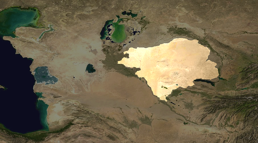
Turan Lowland

Plain · 873,039 km²

Turan Lowland is a plain in Asia, covering an estimated 873,039 km². It extends across Turkmenistan, Uzbekistan and Kazakhstan. It is the 19th-largest of the 231 landforms with a mapped extent in YearMaps.

The Turan Depression, Turan Lowland or Turanian Basin is a low-lying desert basin region stretching from southern Turkmenistan through Uzbekistan to Kazakhstan.

Adapted from Wikipedia: Turan Depression (CC BY-SA 4.0).

Feature class
Plain
Mapped extent
873,039 km²
Size rank
#19 of 231 landforms
Region
Asia
Countries
Turkmenistan, Uzbekistan, Kazakhstan
Coordinates
41.7724°, 62.8901°
Summits:
Ayrybaba (3,137 m)
Ranges:
Karatau Range (Asia), Kopet Dag Mountains (Asia)
Settlements:
Zarafshon (97 km), Urgentch (201 km), Khiwa (228 km)

View on the live map

More about Turan Lowland

Geography

The lowland region lies to the east of the Caspian Sea and southeast of the Aral Sea in the vast Aral–Caspian Depression but extends to parts above sea level as well. It is one of the largest expanses of sand in the world, covering an area of around 3 million km2. On average, the region receives less than 15 inches (380 mm) of rainfall per year. The Karakum desert lies at the southern portion of the Turan Lowlands.

The part of the depression adjacent to the Aral Sea is drainless. It includes a network of temporary streams usually ending in sor salt flats, which seasonally become salt lakes.

Three of the largest cities in the Turan Depression are Daşoguz in Turkmenistan, Nukus in Uzbekistan, and Urganch, also in Uzbekistan. Akjagaýa in Turkmenistan is 267 feet (81 meters) below sea level.

Sections adapted from Wikipedia: Turan Depression (CC BY-SA 4.0).

Tian Shan
Image via Wikimedia Commons (author and licence on the file page).

Tian Shan

Range/mtn · 414,352 km²

Tian Shan is a range/mtn in Asia, covering an estimated 414,352 km². It extends across China, Kyrgyzstan, Kazakhstan and Uzbekistan. It is the 6th-largest of the 216 mountain ranges with a mapped extent in YearMaps.

The Tian Shan, also known as the Tengri Tagh or Tengir-Too, is a large system of mountain ranges in Central Asia. The highest peak is Jengish Chokusu at 7,439 metres (24,406 ft) high and located in Kyrgyzstan. Its lowest point is at the Turpan Depression, which is 154 m (505 ft) below sea level.

The Tian Shan is sacred in Tengrism. Its second-highest peak is known as Khan Tengri, which can be translated as "Lord of the Spirits". At the 2013 Conference on World Heritage, the eastern portion of Tian Shan in western China's Xinjiang Region was listed as a World Heritage Site. The western portion in Kyrgyzstan, Kazakhstan, and Uzbekistan was then listed in 2016.

Adapted from Wikipedia: Tian Shan (CC BY-SA 4.0).

Feature class
Range/mtn
Mapped extent
414,352 km²
Size rank
#6 of 216 mountain ranges
Region
Asia
Countries
China, Kyrgyzstan, Kazakhstan, Uzbekistan
Coordinates
41.6379°, 77.0899°
Summits:
Ayrybaba (3,137 m)
Adjacent ranges:
Pamirs (Asia), Borohoro Mountains (Asia)
Settlements:
Andijon (408 km), Namangan (458 km), Fargona (467 km)

View on the live map

More about Tian Shan

Geography

The Tian Shan range is located north and west of the Taklamakan Desert and directly north of the Tarim Basin. It straddles the border regions of Kazakhstan, Kyrgyzstan, Uzbekistan and Xinjiang in Northwest China. To the south, it connects with the Pamir Mountains, while to north and east, it meets the Altai Mountains of Mongolia.

The Tian Shan range extends eastwards for approximately 2,900 kilometers from Tashkent, Uzbekistan. It forms part of the Himalayan orogenic belt, resulting from the collision of the Indian and Eurasian tectonic plates during the Cenozoic era. The range encompasses the Bogda Shan in the east, as defined by both Western and Chinese cartography.

The Tian Shan's highest peak is Jengish Chokusu (also known as Victory Peak), shared by Kyrgyzstan and China.

Ecology

The Tian Shan holds important forests of Schrenk's spruce (Picea schrenkiana) at altitudes of over 2,000 metres (6,600 ft); the lower slopes have unique natural forests of wild walnuts and apples.

The Tian Shan in its immediate geological past was kept from glaciation due to the "protecting" warm influence of the Indian Ocean monsoon climate. This defined its ecological features which could sustain its distinctive ecosphere. The mountains were subjected to constant geological changes with constantly evolving drainage systems which affected the patterns of vegetation, as well as exposing fertile soil for newly emerging seedlings to thrive in.

Tulips originated in the Tian Shan Mountains. The plant then made its way to Turkey via the Silk Road and became a symbol of the Ottoman Empire.

Sections adapted from Wikipedia: Tian Shan (CC BY-SA 4.0).

Tian Shan: Key Facts

Key facts about Tian Shan
Length2,500 km
Highest pointJengish Chokusu

Facts from Wikidata Q5474 (CC0).

Ustyurt Plateau
Image via Wikimedia Commons (author and licence on the file page).

Ustyurt Plateau

Plateau · 76,986 km²

Ustyurt Plateau is a plateau in Asia, covering an estimated 76,986 km². It extends across Kazakhstan, Uzbekistan and Turkmenistan.

The Ustyurt or Ust-Yurt (from Kazakh: Үстірт; Uzbek: Ustyurt; Turkmen: Üstyurt; Karakalpak: Ústirt — flat hill, plateau) is a transboundary clay desert shared by Kazakhstan, Turkmenistan, and Uzbekistan.

The plateau's semi-nomadic population raises camels, goats, and sheep.

Adapted from Wikipedia: Ustyurt Plateau (CC BY-SA 4.0).

Feature class
Plateau
Mapped extent
76,986 km²
Size rank
#37 of 69 plateaus
Region
Asia
Countries
Kazakhstan, Uzbekistan, Turkmenistan
Coordinates
44.0394°, 55.5062°
Summits:
Ayrybaba (3,137 m)
Ranges:
Kopet Dag Mountains (Asia), Lesser Caucasus (Asia)
Settlements:
Qunghirot (212 km), Chimboy (282 km), Khujayli (290 km)

View on the live map

More about Ustyurt Plateau

Geography

The Ustyurt is located between the Dead Kultuk, Mangyshlak Peninsula and Kara-Bogaz-Gol of the Caspian Sea to the west, and the Aral Sea, Amudarya Delta and Sarygamysh Lake to the east.

It extends roughly 200,000 km2 (77,000 sq mi), with an average altitude of 150 m (490 ft). Its highest point rises to 370 m (1,200 ft) in the south-west. At its northeastern edge it drops steeply to the Aral Sea and the surrounding plain.

The Ustyurt Plateau is bounded by steep cliffs called chinks nearly from everywhere. To the east, it encompasses the historical western shoreline of the Aral Sea. In the southern region, it extends to the Kunya-Darya alluvial plain and the valley of the Uzboy, while in the west, it reaches the Karynyaryk depression.

Sections adapted from Wikipedia: Ustyurt Plateau (CC BY-SA 4.0).

Ustyurt Plateau: Key Facts

Key facts about Ustyurt Plateau
Area200,000 km²
Elevation365 m

Facts from Wikidata Q913329 (CC0).

Fergana Valley
Image via Wikimedia Commons (author and licence on the file page).

Fergana Valley

Valley · 18,784 km²

Fergana Valley is a valley in Asia, covering an estimated 18,784 km². It extends across Uzbekistan, Kyrgyzstan and Tajikistan.

The Fergana Valley (also commonly spelled the Ferghana Valley) in Central Asia crosses eastern Uzbekistan, southern Kyrgyzstan and northern Tajikistan.

Encompassing three former Soviet republics, the valley is ethnically diverse and relations among the countries are tense. Ethnic enclaves, restricted right of movement, lack of agreement about border demarcation and disputes over access to family members and economic activity contribute to tensions.

The Fergana valley owes its fertility to two rivers, the Naryn and the Kara Darya, which run from the east, joining near Namangan, forming the Syr Darya river. The valley's history stretches back over 2,300 years, when Alexander the Great founded Alexandria Eschate at its southwestern end.

According to the dates given by Chinese chroniclers the towns are more than 2,100 years old and were at the crossroads of Greek, Chinese, Bactrian and Parthian civilisations. It was home to Babur, founder of the Mughal dynasty, tying the region to modern Afghanistan and the Indian subcontinent. The Russian Empire conquered the valley at the end of the 19th century, and it became part of the Soviet Union in the 1920s.

Adapted from Wikipedia: Fergana Valley (CC BY-SA 4.0).

Feature class
Valley
Mapped extent
18,784 km²
Size rank
#103 of 231 landforms
Region
Asia
Countries
Uzbekistan, Kyrgyzstan, Tajikistan
Coordinates
40.7110°, 71.8979°
Summits:
Ayrybaba (3,137 m)
Ranges:
Pamirs (Asia), Karatau Range (Asia)
Settlements:
Fargona (33 km), Namangan (37 km), Qoqon (60 km)

View on the live map

More about Fergana Valley

Geography and geology

The Fergana Valley is an intermountain depression in Central Asia, between the mountain systems of the Tien Shan in the north and the Alay in the south. The valley is approximately 300 kilometres (190 mi) long and up to 70 kilometres (43 mi) wide, forming an area covering 22,000 square kilometres (8,500 sq mi). Its position makes it a separate geographic zone. The valley owes its fertility to two rivers, the Naryn and the Kara Darya, which unite in the valley, near Namangan, to form the Syr Darya. Numerous other tributaries of these rivers exist in the valley including the Sokh River.

Climate

The climate of this valley is dry and continental, being mostly a cool arid climate (Köppen BWk) or a cool semi-arid climate (BSk) in less shielded areas. In March the temperature reaches 20 °C (68 °F), and then rapidly rises to 35 °C (95 °F) in June, July and August. During the five months following April precipitation is rare, but increases in frequency starting in October. Snow and frost, down to −20 °C (−4 °F), occurs in December and January.

History

Fergana, on the route to Tarim Basin from the west, remained at the boundaries of a number of classical era empires.

As early as 500 BC, the western sections of the Fergana Valley formed part of the Sogdiana region, which was ruled from further west and owed fealty to the Achaemenid Empire at the time of Darius the Great. The independent and warlike Sogdiana formed a border region insulating the Achaemenid Persians from the nomadic Scythians to the north and east. It was forcibly settled by exiled Greeks from the Anatolian coast, who had rebelled or otherwise given Persia trouble. Eventually, it had a significant Greek community. The capital of the region was known to the Greeks as Cyropolis, named after Cyrus the Great.

Sections adapted from Wikipedia: Fergana Valley (CC BY-SA 4.0).

Fergana Valley: Key Facts

Key facts about Fergana Valley
OnSyr Darya

Facts from Wikidata Q486324 (CC0).

Qizilqum Desert
Image via Wikimedia Commons (author and licence on the file page).

Qizilqum Desert

Desert · 264 km²

Qizilqum Desert is a desert in Asia, covering an estimated 264 km². It extends across Kazakhstan, Turkmenistan and Uzbekistan.

The Kyzylkum Desert (Uzbek: Qizilqum; Kazakh: Qyzylqūm) is the 15th largest desert in the world. Its name means 'Red Sand' in Turkic languages. It is located in Central Asia, in the land between the confluent rivers Amu Darya and Syr Darya, a region historically known as Transoxania. Today it is divided among Kazakhstan, Turkmenistan and Uzbekistan. It covers about 298,000 km2 (115,000 sq mi).

Adapted from Wikipedia: Kyzylkum Desert (CC BY-SA 4.0).

Feature class
Desert
Mapped extent
264 km²
Size rank
#54 of 58 deserts
Region
Asia
Countries
Kazakhstan, Turkmenistan, Uzbekistan
Coordinates
46.8672°, 60.5550°
Summits:
Ayrybaba (3,137 m)
Ranges:
Karatau Range (Asia), Kopet Dag Mountains (Asia)
Settlements:
Qunghirot (442 km), Chimboy (442 km), Nukus (495 km)

View on the live map

More about Qizilqum Desert

Geography

Kyzylkum is mainly located in Uzbekistan. Its territory consists mainly of an extensive plain at an altitude up to 300 m (980 ft) above sea level, with a number of depressions and highlands (Sultanuizdag, Bukantau). Most of the area is covered with dunes (barchans); in the northwest large areas are covered with takirs (clay coatings); there are also some oases. There are agricultural settlements along the rivers and in the oases. Temperatures can be very high during the summer months, from mid-May to mid-September. Kerki, one extreme inland city located on the banks of the Amu Darya River, recorded 52 °C (126 °F) in July 1983.

Economy

The local population uses the large spaces of the Kyzylkum Desert as a pasture for livestock (mostly sheep, Bactrian camels and dromedaries).

The desert is well known for its deposits of gold, uranium, copper, aluminium and silver, natural gas and oil. The development of the most famous gold-field at Muruntau began in the early 1970s. The centres for the mining and smelting industry at the region are Navoi, Zarafshan, Uchkuduk. The major industrial enterprises are: НГМК (Navoi Mining and Smelting Complex) and the Uzbek U.S.A. Joint Venture "Zarafshan-Newmont". The centres of the gas-production industry are Gazli and Mubarek.

Sections adapted from Wikipedia: Kyzylkum Desert (CC BY-SA 4.0).

Qizilqum Desert: Key Facts

Key facts about Qizilqum Desert
Area298,000 km²

Facts from Wikidata Q184364 (CC0).

Garagum Desert
Image via Wikimedia Commons (author and licence on the file page).

Garagum Desert

Desert · 8 km²

Garagum Desert is a desert in Asia, covering an estimated 8 km². It extends across Uzbekistan and Turkmenistan.

The Karakum Desert ( KARR-ə-kum; Russian: Каракумы, IPA: [kərɐˈkumɨ]), also spelt Qaraqum and Garagum (Turkmen: [ɢɑɾɑˈʁʊm]; lit. 'Black Sand'), is the 12th largest desert in the world, located in Central Asia. The name refers to the shale-rich sand beneath the surface. It occupies about 70 percent, or roughly 350,000 km2 (140,000 sq mi), of Turkmenistan.

The population is sparse, with an average of one person per 6.5 km2 (2.5 sq mi). Rainfall is also rare, ranging from 70 to 150 mm (3 to 6 in) per year.

Adapted from Wikipedia: Karakum Desert (CC BY-SA 4.0).

Feature class
Desert
Mapped extent
8 km²
Size rank
#57 of 58 deserts
Region
Asia
Countries
Uzbekistan, Turkmenistan
Coordinates
43.9163°, 58.5558°
Summits:
Ayrybaba (3,137 m)
Ranges:
Kopet Dag Mountains (Asia), Karatau Range (Asia)
Settlements:
Qunghirot (98 km), Chimboy (147 km), Nukus (182 km)

View on the live map

More about Garagum Desert

Geography

The desert covers roughly seventy percent of Turkmenistan, a long east–west swath. It sits east of the Caspian Sea which has a steep east bank. It adjoins, to the north, the long delta feeding the South Aral Sea further north, another endorheic lake, about 58 m (190 ft) higher than the Caspian Sea. The delta is that of the Amu Darya river to the northeast, demarcating the long border with the Kyzylkum Desert of Uzbekistan. The desert is divided into three regions, the elevated northern Trans-Unguz Karakum, the low-lying Central Karakum, and the southeastern Karakum, home to a chain of salt marshes. Since the early 1980s, the relatively small desert extension, the Aralkum, has come to occupy most of the former seabed of the Aral Sea, about 15,440 sq mi (40,000 km2).

Geology

The Karakum is home to the Darvaza gas crater. Also called the "Door to Hell" or the "Gates of Hell" by locals, it is a crater of natural gas that has been burning since 1971. The crater is a major tourist attraction, with hundreds of visitors arriving each year.

Sections adapted from Wikipedia: Karakum Desert (CC BY-SA 4.0).

Garagum Desert: Key Facts

Key facts about Garagum Desert
Area400,000 km²

Facts from Wikidata Q172702 (CC0).

More on Uzbekistan

Quick Answers

What is the largest landform in Uzbekistan?
Turan Lowland, at 873,039 km². Tian Shan is second at 414,352 km². Rankings cover the mountain ranges, deserts and other landforms indexed in YearMaps.
How many mountain ranges, deserts and other landforms are there in Uzbekistan?
YearMaps lists 6 mountain ranges, deserts and other landforms for Uzbekistan. This is the number mapped in the atlas, not an official national count.