Skip to content
YearMaps
7 states800 BCE – 545 CE

Ancient States of the Caucasus: Map & History

7 states of the Caucasus on one map, from 800 BCE to 545 CE.The largest, Kingdom of Urartu, covered about 161,552 km²; the longest-lived, Lazica, lasted 63 BCE – 545 CE. Each has its own section below with its rulers, capitals, wars and pictures where the records hold them.

Fragment of cuneiform inscription of Urartian King Menua, Aghtamar Island, Lake Van
Armen Manukov · CC BY 3.0 · Commons
Downtown Kutaisi & White Bridge as seen from Mt Gora (August 2011)
Kober · CC BY-SA 3.0 · Commons
The Ruins of Ancient Gabala (Azerbaijan)
Emin Bashirov · CC BY-SA 3.0 · Commons
Pharasmanes I from "Rhadamistes and Zenobia" by TAILLASSON, JJ.
Jean-Joseph Taillasson · Public domain · Commons
Base map
800 BC
58 BC
545 AD
800 BC
500 BC
300 BC
0 AD
300 AD
545 AD
Epochs:
↗
↗
↗
↗
↗
↗
↗
↗

Each state in its own colour. Move the timeline to see which existed in any year from 800 BC to 545 AD; select a territory to read about it. Borders: Cliopatria / Seshat (CC BY 4.0).

The Ancient States of the Caucasus Compared

StateYearsCapitalLargest extentRulers
Kingdom of Urartu800 BCE – 551 BCETushpa161,552 km²10
Colchis301 BCE – 231 BCEAea44,265 km²–
Caucasian Albania63 BCE – 509 CEKabalak (Qabala); Partaw (Barda)75,001 km²1
Caucasian Iberia63 BCE – 533 CEArmazi, Mtskheta, Tbilisi35,868 km²37
Kingdom of Adiabene63 BCE – 370 CEArbela13,758 km²1
Kingdom of Commagene63 BCE – 77 CESamosata9,769 km²4
Lazica63 BCE – 545 CEArchaeopolis28,525 km²2

Timeline of the Ancient States of the Caucasus

When each state existed, 800 BCE to 545 CE. Select a year to see the map then.

  1. Kingdom of Urartu
    800 BCE – 551 BCE
  2. Colchis
    301 BCE – 231 BCE
  3. Caucasian Albania
    63 BCE – 509 CE
  4. Caucasian Iberia
    63 BCE – 533 CE
  5. Kingdom of Adiabene
    63 BCE – 370 CE
  6. Kingdom of Commagene
    63 BCE – 77 CE
  7. Lazica
    63 BCE – 545 CE

The 7 States

Kingdom of Urartu

800 BCE – 551 BCE · Capital: Tushpa · 161,552 km²

Fragment of cuneiform inscription of Urartian King Menua, Aghtamar Island, Lake Van
Fragment of cuneiform inscription of Urartian King Menua, Aghtamar Island, Lake Van Armen Manukov · CC BY 3.0 · Commons

Urartu was an ancient civilization and Iron Age kingdom centered on the Armenian highlands between Lake Van, Lake Urmia, and Lake Sevan. The territory of the ancient kingdom of Urartu extended over the modern frontiers of Turkey, Iran, Iraq, and Armenia. Its kings left behind cuneiform inscriptions in the Urartian language, a member of the Hurro-Urartian language family. The kingdom emerged in the mid-9th century BC and dominated the Armenian highlands in the 8th and 7th centuries BC. Urartu frequently warred with Assyria and became, for a time, the most powerful state in the Near East.

From Wikipedia: Urartu (CC BY-SA 4.0)

Origins and Founding

Assyrian inscriptions of Shalmaneser I (c. 1274 BC) first mention Uruatri as one of the states of Nairi, a loose confederation of smaller kingdoms and tribal states in the Armenian Highlands in the thirteenth to eleventh centuries BC which he conquered. Uruartri itself was in the region around Lake Van. The Nairi states were repeatedly subjected to further attacks and invasions by the Middle and Neo-Assyrian Empires, which lay to the south in Upper Mesopotamia ("the Jazirah") and northern Syria, especially under Tukulti-Ninurta I (c. 1240 BC), Tiglath-Pileser I (c. 1100 BC), Ashur-bel-kala (c. 1070 BC), Adad-nirari II (c. 900 BC), Tukulti-Ninurta II (c. 890 BC), and Ashurnasirpal II (883–859 BC).

Read more

Urartu reemerged in Assyrian language inscriptions in the ninth century BC as a powerful northern rival to the Neo-Assyrian Empire.

From Wikipedia: Urartu · History: Origins (CC BY-SA 4.0)

Founded
800 BCE

Capitals

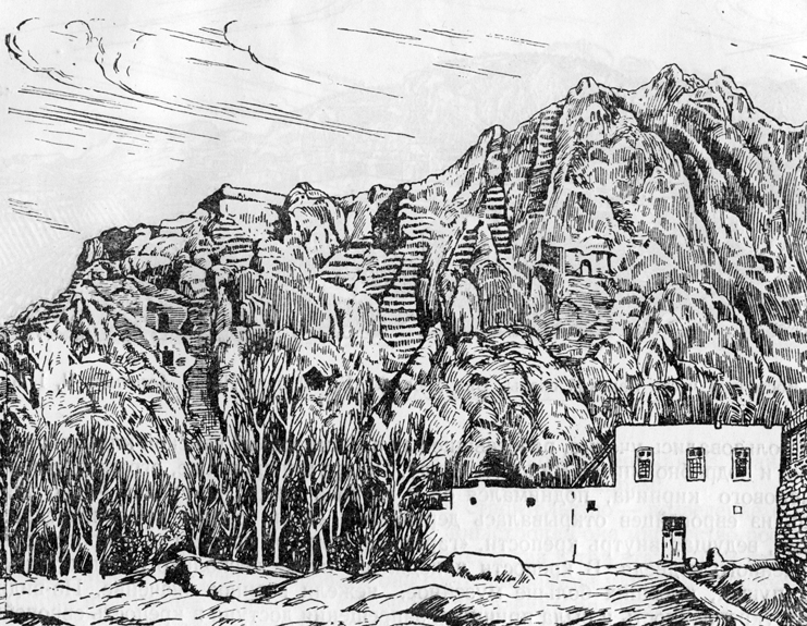
Drawing of Van Cliff made by first researchers of Urartu.
Drawing of Van Cliff made by first researchers of Urartu. Friedrich Eduard Schulz (died in 1829) · Public domain · Commons
Tushpa
Capital
Arzashkun
Capital

Rulers

Government, Society and Religion

"Urartian" is the modern name for the extinct language used in the cuneiform inscriptions of the Kingdom of Urartu. Its only known relative is Hurrian; together they form the small Hurro-Urartian language family. Other names used to refer to the language are "Khaldian" ("Ḫaldian"), or "neo-Hurrian". The latter term is considered problematic, however, as it is now thought that Urartian and Hurrian share a common ancestor; formerly, it was thought that Urartian was descended from, or a dialect of, Hurrian. In fact, according to Paul Zimansky:The earliest dialect of Hurrian, seen in the Tiš-atal royal inscription and reconstructed from various early second millennium B.C.E. sources, shows features that disappeared in later Hurrian but are present in Urartian (Wilhelm 1988:63).

From Wikipedia: Urartu · Language: Urartian language (CC BY-SA 4.0)

Government
Monarchy
Religion
Urartian polytheism

Economy and Trade

The economic structure of Urartu was similar to other states of the ancient world, especially Assyria. The state was heavily dependent on agriculture, which required centralized irrigation. These works were managed by kings, but implemented by free inhabitants and possibly slave labour provided by prisoners. Royal governors, influential people and, perhaps, free peoples had their own allotments. Individual territories within the state had to pay taxes the central government: grain, horses, bulls, etc. In peacetime, Urartu probably led an active trade with Assyria, providing cattle, horses, iron and wine.

Read more

According to archaeological data, farming on the territory of Urartu developed from the Neolithic, even in the 3rd millennium BC. In the Urartian age, agriculture was well developed and closely related to Assyrian methods on the selection of cultures and methods of processing.

From Wikipedia: Urartu · Economy and politics (CC BY-SA 4.0)

Wars and Battles

Achievements and Monuments

There is a number of remains of sturdy stone architecture, as well as some mud brick, especially when it has been burnt, which helps survival. Stone remains are mainly fortresses and walls, with temples and mausolea, and many rock-cut tombs. The style, which developed regional variations, shows a distinct character, partly because of the greater use of stone compared to neighbouring cultures. The typical temple was square, with stone walls as thick as the open internal area but using mud brick for the higher part. These were placed at the highest point of a citadel and from surviving depictions were high, perhaps with gabled roofs; their emphasis on verticality has been claimed as an influence of later Christian Armenian architecture.

From Wikipedia: Urartu · Art and architecture (CC BY-SA 4.0)

Decline and Fall

According to Urartian epigraphy, Sarduri III was followed by two kings—Rusa III (also known as Rusa Erimenahi) (620–609 BC) and his son, Rusa IV (609–590 or 585 BC). There is speculation that Rusa III's father, Erimena, may have been a king as well, possibly ruling from 635 to 620 BC, but little is known about him. It is possible that Rusa III established a new dynasty and that his father, Erimena, had not been king.

Read more

Late during the 7th century BC (during or after Sarduri III's reign), Urartu was invaded by Scythians and their allies—the Medes. In 612 BC, the Median king Cyaxares the Great together with Nabopolassar of Babylon and the Scythians conquered Assyria after it had been irreversibly weakened by civil war. The Medes then took over the Urartian capital of Van in 590 BC, effectively ending the sovereignty of Urartu.

From Wikipedia: Urartu · History: Fall (CC BY-SA 4.0)

Ended
551 BCE
Last recorded ruler
Sarduri IV
Succeeded by
Satrapy of Armenia

Colchis

301 BCE – 231 BCE · Capital: Aea · 44,265 km²

Downtown Kutaisi & White Bridge as seen from Mt Gora (August 2011)
Downtown Kutaisi & White Bridge as seen from Mt Gora (August 2011) Kober · CC BY-SA 3.0 · Commons

In classical antiquity and Greco-Roman geography, Colchis (Ancient Greek: Κολχίς) was an exonym for the Georgian polity of Egrisi (Georgian: ეგრისი) located on the eastern coast of the Black Sea, centered in present-day western Georgia also including the region of Abkhazia. Its population, the Colchians, are generally believed to have been primarily early Zan-speaking tribes, ancestral to the modern Laz and Mingrelian peoples.

From Wikipedia: Colchis (CC BY-SA 4.0)

Origins and Founding

The eastern Black Sea region in antiquity was home to the well-developed Bronze Age culture known as the Colchian culture, related to the neighbouring Koban culture, that emerged toward the Middle Bronze Age. In at least some parts of Colchis, the process of urbanization seems to have been well advanced by the end of the second millennium BC. The Colchian Late Bronze Age (fifteenth to eighth century BC) saw the development of significant skill in the smelting and casting of metals. Sophisticated farming implements were made, and fertile, well-watered lowlands and a mild climate promoted the growth of progressive agricultural techniques.

Read more

The earliest attestations of the name of Colchis can be found in the 8th century Greek poet Eumelus of Corinth as Κολχίδα and earlier, in Urartian records as Qulḫa mentioned by the Urartian kings.

From Wikipedia: Colchis · History: Prehistory and earliest references (CC BY-SA 4.0)

Founded
301 BCE

Government, Society and Religion

Languages
Zan, Svan, Greek (decrees, numismatics), many others
Religion
Georgian paganism, Greek polytheism, Mithraism, Zoroastrianism

Economy and Trade

Millet was the main staple crop in Colchis. Wheat grew in certain regions and was also imported by sea. Similarly, local wines were produced and some wines were brought from overseas. The Colchian plain provided ample grazing land for cattle and horses, with the name of Phasis associated with fine horses. The wetlands were a home for waterfowl, while Colchian pheasants were exported to Rome and became a symbol of excess condemned by Roman moralists. The Colchian hinterland lacked salt and demand was satisfied partially by local production on the coast and partially by imports from the northern coast of the Black Sea.

Read more

Colchis provided slaves as a tribute to the Achaemenid Empire and Colchian slaves are also attested in Ancient Greece.

From Wikipedia: Colchis · Economy, agriculture and natural resources (CC BY-SA 4.0)

Wars and Battles

Caucasian Albania

63 BCE – 509 CE · Capital: Kabalak (Qabala); Partaw (Barda) · 75,001 km²

The Ruins of Ancient Gabala (Azerbaijan)
The Ruins of Ancient Gabala (Azerbaijan) Emin Bashirov · CC BY-SA 3.0 · Commons

Caucasian Albania is a modern exonym for a former state located in ancient times in the Caucasus, mostly overlapping the region of present-day Azerbaijan. The modern endonyms for the area are Aghwank and Aluank, among the Udi people, who regard themselves as descended from the inhabitants of Caucasian Albania. However, its original endonym is unknown. The name Albania is derived from the Ancient Greek name Ἀλβανία and Latin Albanía, created from Greek sources that incorrectly translated the Armenian language.

From Wikipedia: Caucasian Albania (CC BY-SA 4.0)

Origins and Founding

Originally, at least some of the Caucasian Albanians probably spoke Lezgic languages close to those found in modern Dagestan; overall, though, as many as 26 different languages may have been spoken in Caucasian Albania.

Read more

According to the linguist Jost Gippert, the ancestors of the peoples of the Lezgic language group—including the Budukhs, Kryts, Lezgins, Rutulians, Tsakhurs, and others—historically lived in the territory of Caucasian Albania.

After the Caucasian Albanians were Christianized in the 4th century, part of the population was assimilated by the Armenians (who dominated in the provinces of Artsakh and Utik that were earlier detached from the Kingdom of Armenia) and Georgians (in the north), while the eastern parts of Caucasian Albania were Islamized and absorbed by Iranian and subsequently Turkic peoples (modern Azerbaijanis).

From Wikipedia: Caucasian Albania · Ethnogenesis (CC BY-SA 4.0)

Founded
63 BCE

Capitals

Kabalaka
Capital
Partav
Capital

Rulers

  • Juansher
    Juansherlived 616–683 CEUnknown authorUnknown author · Public domain · Commons

Government, Society and Religion

Government
absolute monarchy
Languages
Caucasian Albanian, Parthian
Religion
Paganism, Christianity, Zoroastrianism

Wars and Battles

Legacy in the Modern World

Armenian politics, culture and civilization played a critical role in the entire history of Caucasian Albania (Aghvank, in Armenian). This, due to the fact that after the partition of the Kingdom of Armenia by Persia and Byzantium in 387 AD, the Armenian provinces of Artsakh and Utik were disassociated from the Armenian kingdom and included by Persians into a single province (marzpanate) called Aghvank (Arran). This new unit included: the original Caucasian Albania, found between the River Kura and the Great Caucasus; tribes living along the Caspian shore; as well as Artsakh and Utik, two territories now detached from Armenia.

From Wikipedia: Caucasian Albania · History: Impact of Armenian politics, culture and civilization (CC BY-SA 4.0)

Caucasian Iberia

63 BCE – 533 CE · Capital: Armazi, Mtskheta, Tbilisi · 35,868 km²

Pharasmanes I from "Rhadamistes and Zenobia" by TAILLASSON, JJ.
Pharasmanes I from "Rhadamistes and Zenobia" by TAILLASSON, JJ. Jean-Joseph Taillasson · Public domain · Commons

In Greco-Roman geography, Iberia was an exonym for the Georgian kingdom of Kartli, known after its core province. The kingdom existed during Classical Antiquity and the Early Middle Ages, either as an independent state or as a dependent of larger empires, notably the Sassanid and Roman empires. Iberia, centered on present-day eastern Georgia, was bordered by Colchis in the west, Caucasian Albania in the east and Armenia in the south. Its population, the Iberians, formed the nucleus of the Kartvelians (i.e., Georgians).

From Wikipedia: Kingdom of Iberia (CC BY-SA 4.0)

Origins and Founding

In earliest times, the area of Caucasian Iberia was inhabited by several related tribes stemming from the Kura-Araxes culture.

Read more

According to Cyril Toumanoff, the Moschians were an early proto-Georgian tribe that played a leading role in the consolidation of Iberian tribes largely inhabiting eastern and southern Georgia. The Moschians may have moved slowly to the northeast, forming settlements as they traveled. One of these settlements was Mtskheta, the future capital of the Kingdom of Iberia. The Mtskheta tribe was later ruled by a prince locally known as mamasakhlisi ("father of the household" in Georgian).

The written sources for the early periods of Iberia's history are mostly medieval Georgian chronicles, which modern scholarship interprets as semi-legendary narratives.

From Wikipedia: Kingdom of Iberia · History: Early history (CC BY-SA 4.0)

Founded
63 BCE

Capitals

Mtskheta at the rivers Araqvi und Mtkvari
Mtskheta at the rivers Araqvi und Mtkvari Gerd Eichmann · CC BY-SA 4.0 · Commons
Mtskheta
Capital
Tbilisi
Capital
Armaztsikhe
Capital

Rulers

Government, Society and Religion

Government
Monarchy
Languages
Greek–Aramaic (governance, literacy, and culture), Old Georgian (governance, literacy, and native language)
Religion
Georgian paganism, Zoroastrianism, Christianity (from 319)

Coins, Currency and Symbols

Currency
Kolkhuri Tetri

Wars and Battles

Decline and Fall

The continuing rivalry between Byzantium and Sasanian Persia for supremacy in the Caucasus had severe consequences for Iberia. The unsuccessful uprising of 523, led by the Georgians under Gurgen, weakened the kingdom. Thereafter, the Iberian king retained only nominal authority, while real power was exercised by the Persians. In 580, Hormizd IV (578–590) abolished the monarchy following the death of King Bacurius III, converting Iberia into a Persian province administered by a marzpan (governor). Georgian nobles appealed to the Byzantine emperor Maurice to restore the kingdom in 582, but in 591 Byzantium and Persia agreed to divide Iberia: Tbilisi remained under Persian control, while Mtskheta came under Byzantine administration.

Read more

At the beginning of the 7th century, the truce between Byzantium and Persia collapsed.

From Wikipedia: Kingdom of Iberia · History: Fall of the kingdom (CC BY-SA 4.0)

Ended
533 CE
Succeeded by
Sasanian Iberia

Kingdom of Adiabene

63 BCE – 370 CE · Capital: Arbela · 13,758 km²

Ադիաբենեի Թագավորություն
Ադիաբենեի Թագավորություն Վազգեն Ղազարյան at Armenian Wikipedia · CC BY-SA 3.0 · Commons

Adiabene (Greek: Ἀδιαβηνή, Classical Syriac: ܚܕܝܐܒ) was an ancient kingdom in northern Mesopotamia, corresponding to the heartland of ancient Assyria. The size of the kingdom varied over time; initially encompassing an area between the Zab Rivers, it eventually gained control of Nineveh and starting at least with the rule of Monobazos I (late 1st-century BCE), Gordyene became an Adiabenian dependency. It reached its zenith under Izates II, who was granted the district of Nisibis by the Parthian king Artabanus II (r. 12–40) as a reward for helping him regain his throne.

From Wikipedia: Adiabene (CC BY-SA 4.0)

Rulers

Government, Society and Religion

Adiabene had a mixed population of Assyrians, Arabs, Arameans, Greeks, Iranians, and Jews. Adiabene was a major-speaking Syriac language kingdom. According to Pliny, four tribes inhabited the region of Adiabene: Orontes, Alani, Azones and Silices. The account of Josephus' Antiquities of the Jews shows that there was a substantial Jewish population in the kingdom. The difficult mixing of cultures can be seen in the story of the martyrdom of Mahanuš, a prominent Iranian Zoroastrian who converted to Christianity. In later times Adiabene became an archbishopric, with the seat of the metropolitan at Arbela.

Read more

The first known king of Adiabene was Abdissar who is known to scholarship only through his coinage, his Semitic name, meaning "the servant of Ishtar," suggests that he was of local Assyrian origin.

From Wikipedia: Adiabene · Population (CC BY-SA 4.0)

Government
Monarchy
Languages
Classical Syriac
Religion
Ashurism, Judaism, Zoroastrianism, Christianity, Manichaeism

Kingdom of Commagene

63 BCE – 77 CE · Capital: Samosata · 9,769 km²

Commagene's map
Commagene's map Ferhates · CC BY-SA 3.0 · Commons

Commagene (Ancient Greek: Κομμαγηνή) was an ancient Greco-Iranian kingdom ruled by a Hellenized branch of the Orontids, a dynasty of Iranian origin, that had ruled over the Satrapy of Armenia. The kingdom was located in and around the ancient city of Samosata, which served as its capital. The Iron Age name of Samosata, Kummuh, probably gives its name to Commagene. Commagene has been characterized as a "buffer state" between Armenia, Parthia, Syria, and Rome; culturally, it was correspondingly mixed.

From Wikipedia: Commagene (CC BY-SA 4.0)

Rulers

Government, Society and Religion

Government
Monarchy
Languages
Greek (official), Persian (early ruling dynasty), Aramaic (common)
Religion
Greco-Iranian religious syncretism

Wars and Battles

Achievements and Monuments

The cultural identity of the Kingdom of Commagene has been variously characterized. Pierre Merlat suggests that the Commagenian city of Doliche, like others in its vicinity, was "half Iranianized and half Hellenized". David M. Lang describes Commagene as "a former Armenian satellite kingdom", while Blömer and Winter call it a "Hellenistic kingdom". Millar suggests that a local dialect of Aramaic might have been spoken there, Fergus Millar considers that, "in some parts of the Euphrates region, such as Commagene, nothing approaching an answer to questions about local culture is possible."

Read more

While the language used on public monuments was typically Greek, Commagene's rulers made no secret of their Persian affinities.

From Wikipedia: Commagene · Cultural identity (CC BY-SA 4.0)

Lazica

63 BCE – 545 CE · Capital: Archaeopolis · 28,525 km²

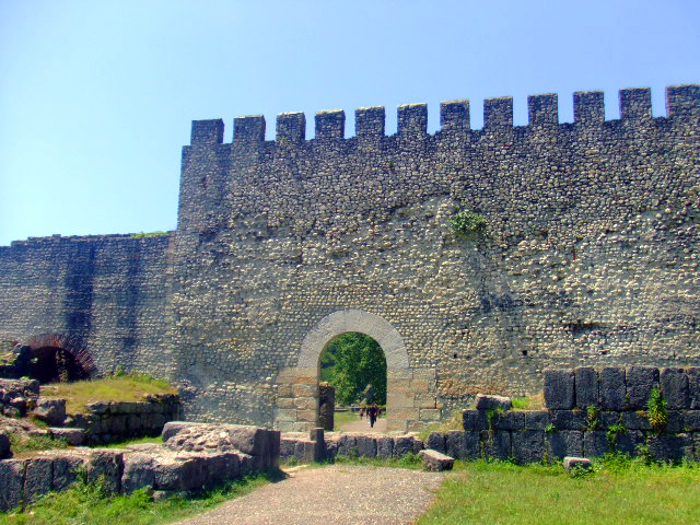
Nokalakevi
Nokalakevi Lika (ლიკა) · Public domain · Commons

The Kingdom of Lazica (Georgian: ეგრისი, romanized: Egrisi; Laz: ლაზიკა, romanized: Laziǩa; Ancient Greek: Λαζική, romanized: Lazikḗ), sometimes called Lazian Empire, was a state in the territory of west Georgia in the Roman period, from about the 1st century BC. Created as a result of the collapse of the kingdom of Colchis and the gaining of independence by the tribal-territorial units included in it in 131 AD.

From Wikipedia: Lazica (CC BY-SA 4.0)

Rulers

  • Malassas (first)
  • Tzath II (last)

Government, Society and Religion

Languages
Zan, Old Georgian, Greek (religious)
Religion
Georgian paganism, Eastern Orthodoxy (pre-Schism)

Economy and Trade

Maritime trade played a significant role in the country's economy, with the port of Phasis serving as its main center. Trade was conducted mainly with Pontus and the Bosporan Kingdom in Crimea, which were under Roman control at the time. Leather, fur, and other raw materials, as well as slaves, were exported from Lazica in large quantities. In return, the Laz imported salt, bread, wine, luxury textiles, and weapons. The destruction of free trade and the introduction of a Roman trade monopoly in Lazica are considered among the causes of the Lazic War.

Read more

The primary currency used in Lazica for trade was the Roman Antoninianus until the 4th century. Afterwards it was replaced by the Byzantine Solidus.

From Wikipedia: Lazica · Economy (CC BY-SA 4.0)

Coins, Currency and Symbols

Currency
Antoninianus until IV A.D, later Solidus

Wars and Battles

Ancient States of the Caucasus: Frequently Asked Questions

Which states existed in the Caucasus in this period?

This page maps 7 states of the Caucasus founded between 800 BCE and 63 BCE: Kingdom of Urartu, Colchis, Caucasian Albania, Caucasian Iberia, Kingdom of Adiabene, Kingdom of Commagene, Lazica.

Which was the largest of the Ancient States of the Caucasus?

Kingdom of Urartu had the largest mapped extent, about 161,552 km².

Which of the Ancient States of the Caucasus lasted longest?

Lazica lasted longest, 63 BCE – 545 CE.

Sources

  • Reading text: Wikipedia articles on the group and each state, condensed (CC BY-SA 4.0).
  • Facts, rulers and wars: Wikidata (CC0).
  • Borders: Cliopatria, Seshat Global History Databank (CC BY 4.0).
  • Pictures: Wikimedia Commons; the author and licence are under each picture.

Largest state by mapped extent: Kingdom of Urartu.