
The 1992 Great Pacific Rubber Duck Spill
On January 10, 1992, a container ship lost 28,800 plastic bath toys into the North Pacific Ocean near the International Date Line. For nearly two decades, these toys circled the globe—washing ashore in Alaska, Hawaii, frozen into Arctic pack ice, and arriving on the beaches of Europe.
Try it: drop your own container
- Press Ducks in the bottom-right corner of the globe, and choose Drop ducks.
- Tap any open ocean. A container bursts there and its colourful rubber ducks start to drift.
- Drag the speed slider to speed time up or slow it down. Fast jets like the Gulf Stream stretch the ducks into a line, gyres swirl them in slow circles, and coasts catch them (grey ducks have washed ashore).
- Switch to 1992 replay to follow the real spill near the International Date Line, with pins where the toys were found.
- Press Currents to see the major warm and cold currents with arrows showing their flow, or Events for 3D animations of low and high pressure, cyclones, upwelling and El Niño.
The white streaks are real surface currents from the U.S. Navy's HYCOM ocean model. Open the earth menu and switch Mode to Air for winds, or pick an Overlay such as SST for sea temperature.
Northern and Southern Hemispheres, and the lines that divide the Earth
Open Globe on the map above to draw these lines on the 3D globe and tint each hemisphere.
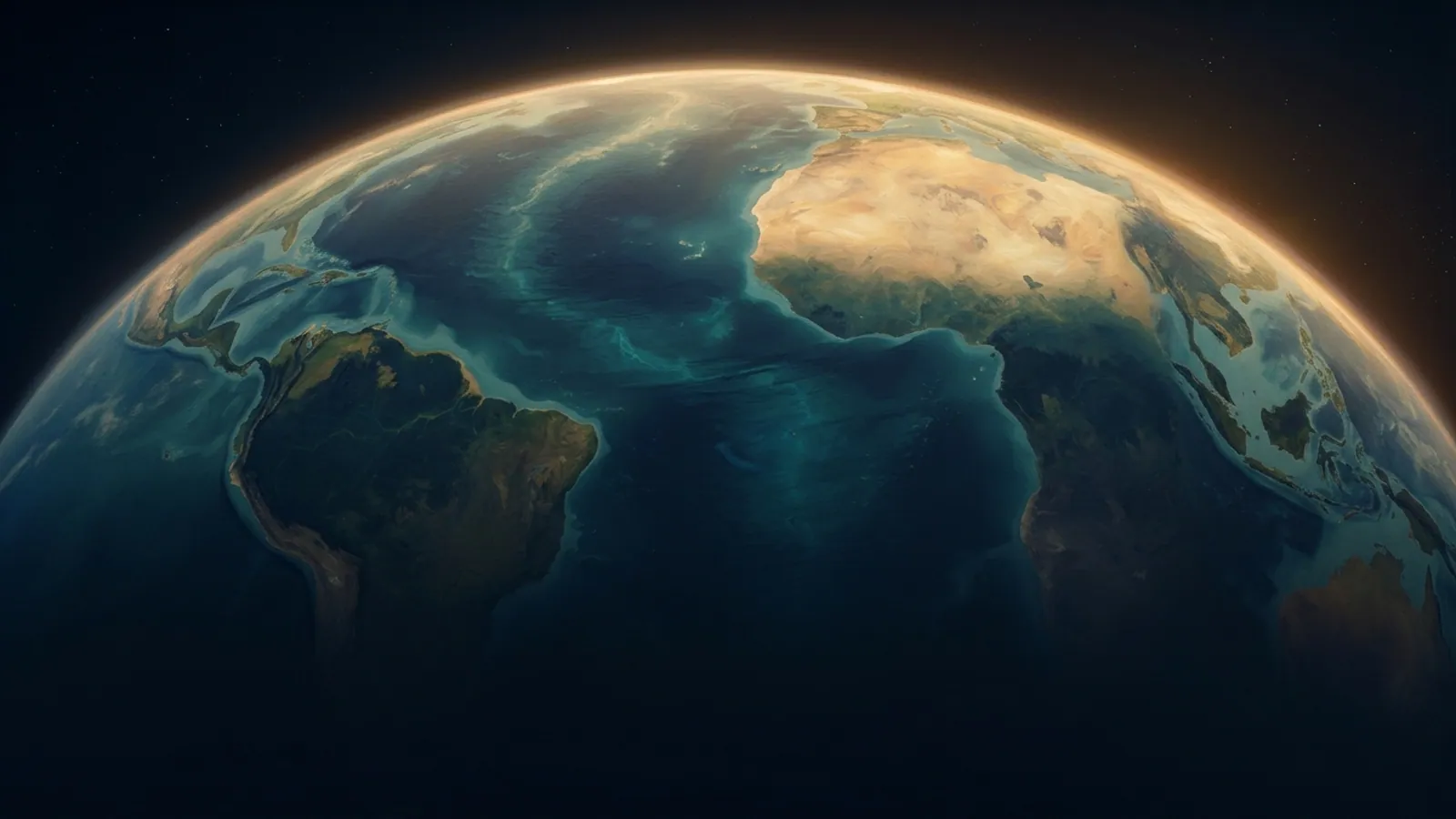
An imaginary line around the middle of the Earth, the same distance from the North and South Poles. It is 40,075 km long and divides the globe into the Northern and Southern Hemispheres. Latitude is measured north and south from it.

Everything north of the Equator: all of Europe and North America, most of Asia and about two-thirds of Africa. It holds about two-thirds of the world's land and almost 90% of its people. Ocean gyres turn clockwise here, and storms spin anticlockwise.

Everything south of the Equator: Antarctica, Australia, most of South America and southern Africa. It is mostly ocean, about 81% water. Ocean gyres turn anticlockwise here, storms spin clockwise, and the seasons are the opposite of the north: December is summer.

The farthest north (Cancer, 23.4° N) and south (Capricorn, 23.4° S) that the Sun is ever directly overhead, at the June and December solstices. They mark the edges of the tropics, the warmest zone of the Earth, where warm currents and tropical cyclones begin.

Beyond these circles (66.6° N and 66.6° S) the Sun stays up for 24 hours on at least one day of summer and does not rise on at least one day of winter. Sea ice forms in the polar oceans inside them.

A line from pole to pole through Greenwich, London. Longitude is measured east and west from it, up to 180° on the opposite side of the world, near where the International Date Line runs (and where the 1992 ducks were spilled).

The line where the date changes: step west across it and you jump a day forward, step east and you repeat the day. It mostly follows 180°, halfway round the world from Greenwich, but it bends around land so that no country is cut in two: east around Russia’s Chukotka and through the Bering Strait between the two Diomede Islands (3.8 km apart, 21 hours apart), west of the Aleutians, then far east around Kiribati and between Samoa and American Samoa. It is set by each country’s own time laws, not by treaty, so it has moved several times.

The half of the Earth east of the Prime Meridian, up to 180°: most of Europe, Africa, Asia and Australia.

The half of the Earth west of the Prime Meridian, up to 180°: North and South America and most of the Pacific Ocean.
The world's major ocean currents
Warm currents carry heat away from the tropics; cold currents bring cool water from the poles or from the deep. Between them they move heat around the planet and decide where it rains, where deserts form and where fish are plentiful.
| Current | Type | Ocean | What it does |
|---|---|---|---|
| Gulf Stream | Warm | Atlantic | It carries tropical heat north-east. Storms that cross it strengthen over its warm water, and it brings mild air to western Europe through the North Atlantic Drift. |
| North Atlantic Drift | Warm | Atlantic | It keeps north-west Europe far milder than places at the same latitude in Canada, and keeps Norway's northern ports free of ice in winter. |
| Canary Current | Cold | Atlantic | Winds along the coast pull cold, nutrient-rich water up from below (upwelling), feeding rich fisheries off north-west Africa. The cool air it brings helps keep the Sahara's coast dry. |
| North Equatorial Current (Atlantic) | Warm | Atlantic | Hurricanes that form off Africa travel west along the same path, over its warm water. |
| Labrador Current | Cold | Atlantic | Where it meets the warm Gulf Stream off Newfoundland it makes some of the foggiest seas on Earth, and it carries icebergs south — the Titanic sank in its waters in 1912. |
| Brazil Current | Warm | Atlantic | It meets the cold Falklands Current off Argentina; that clash makes a band of swirling eddies and a rich feeding ground. |
| Falklands (Malvinas) Current | Cold | Atlantic | It brings cold, nutrient-rich water that supports squid, penguins and seabirds. |
| Benguela Current | Cold | Atlantic | Strong upwelling makes it one of the richest fishing grounds in the world. The cold water chills the air above it, which is why the Namib Desert gets almost no rain but frequent fog. |
| South Equatorial Current (Atlantic) | Warm | Atlantic | At Brazil's eastern tip it splits, feeding both the Brazil Current and the water that flows into the Caribbean. |
| Kuroshio | Warm | Pacific | It warms southern Japan, feeds typhoons that pass over it, and carries fish larvae and floating debris far out into the Pacific. |
| North Pacific Current | Mixed | Pacific | Near North America it splits: the Alaska Current turns north, the California Current turns south. |
| Alaska Current | Warm | Pacific | It keeps the coast of south-east Alaska ice-free. The first 1992 rubber ducks washed up at Sitka after riding it. |
| California Current | Cold | Pacific | It gives San Francisco its summer fog and cool beaches, and upwelling along the coast feeds kelp forests, sea lions and whales. |
| Oyashio | Cold | Pacific | Its nutrients nourish the fish of northern Japan. Where it meets the warm Kuroshio, sea fog and rich fishing grounds form. |
| North Equatorial Current (Pacific) | Warm | Pacific | It piles warm water up in the western Pacific, where it feeds the Kuroshio and the world's strongest typhoons. |
| Equatorial Counter Current | Warm | Pacific | During El Niño it strengthens and helps carry warm water east towards South America. |
| South Equatorial Current (Pacific) | Warm | Pacific | In El Niño years the trade winds weaken and this current slows or even reverses. |
| Humboldt (Peru) Current | Cold | Pacific | It supports the world's biggest fishery (anchovy). The cold water keeps the Atacama, the driest desert on Earth, almost rainless. When El Niño weakens it, the fish disappear and the desert floods. |
| East Australian Current | Warm | Pacific | It carries tropical fish and warm water south towards Sydney and Tasmania, and sheds big swirling eddies into the Tasman Sea. |
| Agulhas Current | Warm | Indian | Where it meets big swells from the Southern Ocean it can raise freak waves that have broken ships. Rings of its warm water drift into the Atlantic. |
| West Australian Current | Cold | Indian | Its cool water helps keep Western Australia's coast dry. |
| Somali Current | Warm | Indian | The summer monsoon winds that drive it also carry moist ocean air to India. Strong upwelling along Somalia makes the coast unusually cool. |
| Antarctic Circumpolar Current | Cold | Southern | It keeps Antarctica cold by walling it off from warmer water, and links the Atlantic, Pacific and Indian Oceans into one system. |
| Transpolar Drift | Cold | Arctic | Floating things frozen into the ice cross the pole on it: some 1992 rubber ducks are thought to have taken this route into the Atlantic. |
| East Greenland Current | Cold | Arctic | It carries sea ice and icebergs into the North Atlantic. |
Weather and ocean events caused by currents and pressure
Open Events on the globe to see each of these in today's real data, and watch the low-pressure, high-pressure, cyclone, upwelling and El Niño ones as 3D animations.

Warm, moist air converges, rises, cools and turns into clouds and rain.

Cool air sinks, warms, spreads out and dries the sky.

A low pressure system fed by warm ocean water grows into a giant storm.
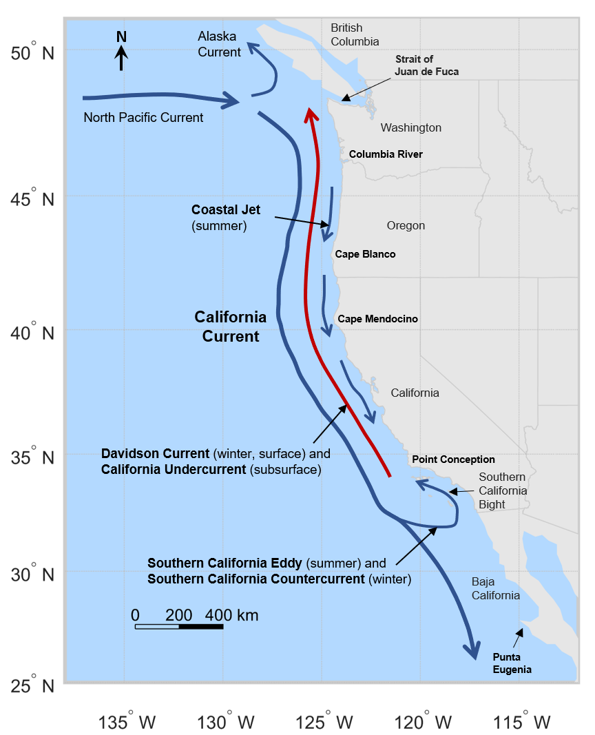
Wind pushes surface water offshore, and cold, nutrient-rich water rises.
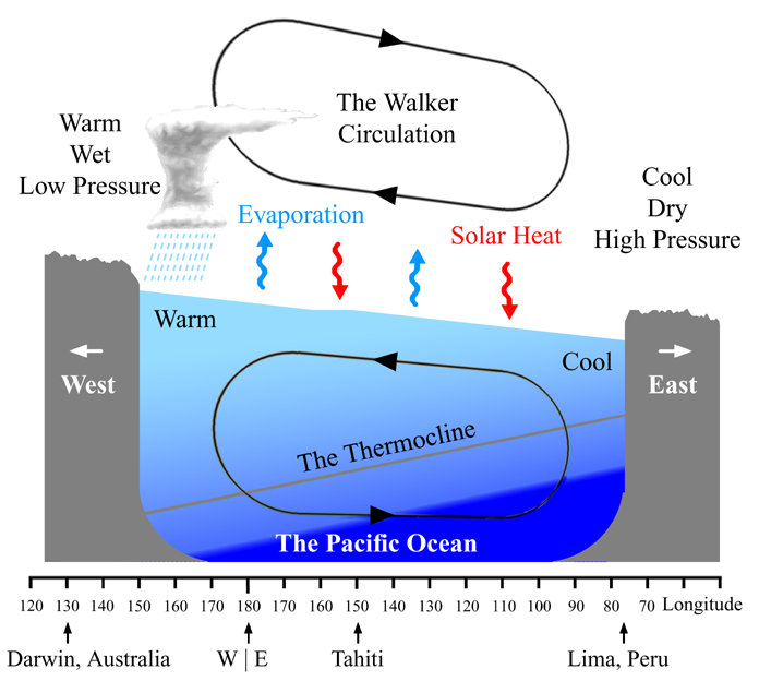
The trade winds weaken and warm water floods east across the Pacific.

Stronger trade winds, colder water in the eastern Pacific.

Land heats faster than the sea, so moist ocean air is pulled inland as rain.
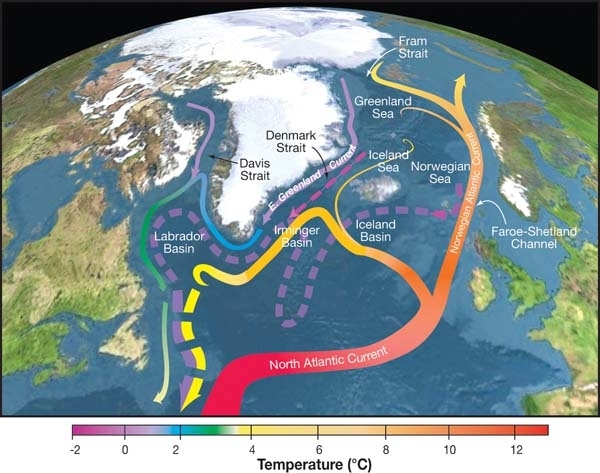
The Gulf Stream and North Atlantic Drift carry tropical heat to Europe.

Cold water chills the air from below, so it cannot rise to make rain.

Warm, moist air passing over cold water cools into fog.

Circling currents gather floating plastic into the middle of each ocean.

Water that stays too warm makes corals expel the algae that feed them.
1The Winter Storm of January 1992
In early January 1992, the container ship Ever Laurel departed Hong Kong bound for the port of Tacoma, Washington. Midway across the North Pacific near the 180th meridian (the International Date Line), the vessel struck hurricane-force storm conditions with waves over 36 feet high.
Twelve 40-foot intermodal containers broke their lashings and tumbled into the ocean. One of these steel containers burst upon impact, casting 28,800 sealed plastic bath toys into the freezing open waters.
2Alaska, Hawaii, and the Gyre Bifurcation
Ten months after the accident (November 1992), beachcombers in Sitka, Alaska began discovering hundreds of yellow ducks and blue turtles along the rocky shoreline, 3,200 km east of the spill site. The toys had completed the voyage at an average pace of 11 kilometers per day.
However, not all ducks stayed in Alaska. As the North Pacific Current approached North America, it split into two branches: the counter-clockwise Alaskan Subpolar Gyre (carrying ducks north) and the clockwise California Current (carrying ducks south). By 1995, hundreds of ducks washed up on the white sands of Hawaii (Maui, Oahu, and Lanai)!
3Trapped in Arctic Ice: The Transpolar Drift (1998–2003)
In 1998, thousands of remaining toys squeezed through the narrow Bering Strait into the Arctic Ocean. Here, the ducks became frozen into thick polar sea ice pack. Moving at a glacial pace of 1.6 km/day, they rode the Transpolar Drift Stream across the North Pole.
In 2003, as the sea ice thawed in the Greenland Sea, the bleached ducks emerged into the North Atlantic Ocean. Within months, toys were collected on the shores of Maine and Massachusetts, confirming the trans-Arctic marine transit route.
4European Landfall & Modern Legacy (2004–2010+)
Riding the powerful Gulf Stream and North Atlantic Drift, the resilient toys crossed the Atlantic. Between 2004 and 2007, collectors discovered them in the Scottish Hebrides, southwest England, Ireland, and Brittany, France. By 2010, after 18 years and more than 34,000 kilometers, occasional ducks were still turning up in Australia and South Africa.
Where the Toys Went: Finds, Sightings and Predictions
| Date | Landfall Location | Distance | Ocean Basin |
|---|---|---|---|
| 1992-01-10 | North Pacific Ocean (44.7° N, 178.1° E) | 0 km | The Great Cargo Spill in the Storm |
| 1992-11-16 | Near Sitka, Alaska | 3,200 km | First Beach Landfall: Sitka, Alaska |
| 1995-07-20 | Hawaiian Islands(reported) | 8,500 km | Warm Hawaiian Shores: Subtropical Gyre Diversion |
| 1996 | Pacific coast of Washington, USA | 9,200 km | Return to the Pacific Northwest: Washington State |
| 1998-09-01 | Bering Strait & Chukchi Sea(predicted) | 12,000 km | Into the Arctic Ice (Predicted Route) |
| 2003-07-14 | Coast of Maine, USA(reported sighting) | 19,000 km | Atlantic Re-emergence: Maine |
| 2004-08-20 | Hebrides, Scotland(reported sighting) | 27,000 km | The European Landfall: Scotland |
| — | Eastern Australia(reported) | 13,000 km | Reached the Australian Shores |
| — | New Guinea, Indonesia(reported) | 14,300 km | Reached the Indonesian Shores |
| — | Southern Chile(reported) | 15,100 km | Reached the Shores of South America |
Photo credits for the tile pictures
Each picture is an openly licensed file from Wikimedia Commons (public domain, CC0, CC BY or CC BY-SA).
- The Equator (0°): Atlas, AI-generated
- Northern Hemisphere: Sean Baker ( Marvin01 | talk ), CC BY 2.0
- Southern Hemisphere: Sean Baker ( Marvin01 | talk ), CC BY 2.0
- Eastern Hemisphere: Sean Baker ( Marvin01 | talk ), CC BY 2.0
- Western Hemisphere: Sean Baker ( Marvin01 | talk ), CC BY 2.0
- Tropics of Cancer and Capricorn (23.4°): Thesevenseas ( talk ), CC BY-SA 3.0
- Arctic and Antarctic Circles (66.6°): Thesevenseas ( talk ), CC BY-SA 4.0
- Prime Meridian (0°) and 180°: NuclearVacuum, CC BY-SA 3.0
- The International Date Line: NASA, Public domain
- Low pressure brings rain: NASA/GSFC, MODIS Rapid Response Team, Jacques Descloitres, Public domain
- High pressure brings clear skies: NASA, MODIS Rapid Response System, Public domain
- Tropical cyclones (hurricanes, typhoons): NASA/Goddard Space Flight Center, CC BY 2.0
- Coastal upwelling: Cormorant24, CC BY-SA 4.0
- El Niño: PAR, Public domain
- La Niña: Content published by Rebecca Lindsey and reviewed by Tom Di Liberto. Image credi, Public domain
- The monsoon: w:user:PlaneMad, CC BY-SA 3.0
- Why western Europe is mild: R. Curry, Woods Hole Oceanographic Institution/Science/USGCRP., CC BY 3.0
- Cold currents make coastal deserts: Jeff Schmaltz, MODIS Land Rapid Response Team, NASA GSFC, Public domain
- Sea fog over cold currents: Abdul Momin, CC BY-SA 4.0
- Garbage patches in the gyres: L. Lebreton, B. Slat, F. Ferrari, B. Sainte-Rose, J. Aitken, R. Marthouse, S. Ha, CC BY 4.0
- Coral bleaching: Acropora at English Wikipedia, CC BY-SA 3.0
How Flotsam Drifts, and What a Simulator Cannot Tell You
The simulator moves each duck with the surface current plus a small push from the wind. Those are the forces that set any floating object adrift, and the spill of 1992 is how scientists learned to measure the second one.

Four things that move a floating object
The great gyres are driven by the wind and turned by the Earth’s rotation: clockwise in the northern hemisphere, anticlockwise in the southern. Within the top layer of the sea, Ekman transport moves the water at an angle to the wind, up to about 45 degrees, which is why drift tracks curve away from the way the wind blows. Then there is leeway, the wind’s push on whatever sits above the waterline: a hollow duck rides high and catches the wind, a waterlogged log hardly at all, so two objects dropped together soon part. Last, where surface waters meet and sink, floating things gather and stay, which is how the garbage patches form.
Studies of the toys put the leeway of a floating duck at roughly 1 to 3 per cent of the wind speed, added to the current. That is the term this simulator uses.

It started with shoes
In May 1990, about 61,000 Nike shoes went overboard in a storm in the same part of the North Pacific. Shoes make better drift markers than toys: each has a serial number inside, so pairs could be matched and traced to a single container. The oceanographer Curtis Ebbesmeyer and the modeller James Ingraham used the beachcombers’ reports to test their current model, OSCURS, and the bath toys of 1992 gave them a second, larger experiment.

What this simulator cannot do
No model can say where one particular duck will land years from now. Ocean drift is chaotic: two objects a kilometre apart can end up on different continents. What a model can predict is where a crowd of objects is likely to spread.
The current data has a grid, and eddies smaller than it are not represented, though they matter. The wind’s push depends on the object, so the duck’s figure does not apply to a log, a container or a person in the water. And the real-world sightings that check such models come mostly from busy, accessible beaches: no reports from the Siberian coast does not mean no ducks reached it.
Checked against: C. Ebbesmeyer and W. J. Ingraham on the 1990 and 1992 spills and the OSCURS model; Lebreton et al., Scientific Reports (2018), on the North Pacific garbage patch.
Frequently Asked Questions: The Friendly Floatees
How did rubber ducks end up in the ocean in 1992?
On January 10, 1992, the container ship Ever Laurel was en route from Hong Kong to Tacoma, Washington, USA. During a severe storm in the North Pacific Ocean, 12 containers were washed overboard. One of them broke open, releasing 28,800 plastic bath toys (yellow ducks, blue turtles, red beavers, and green frogs) into the water.
Why did the rubber ducks survive for decades without sinking?
Unlike modern bath toys that have a small squeaker hole (which fills with water and grows mold), the 1992 Friendly Floatees were manufactured without any drainage holes. They were completely sealed, airtight plastic capsules made of thick polyethylene that floated permanently.
How did oceanographer Curtis Ebbesmeyer track the ducks?
Curtis Ebbesmeyer set up a global network of beachcombers, coastal residents, lighthouse keepers, and scientists. Whenever someone found one of the distinctive toys, they reported the exact date and location. Ebbesmeyer combined these reports with computer ocean models (like OSCAR) to map global surface currents.
How did toys spilled in the Pacific Ocean end up in the Atlantic Ocean and Europe?
After completing loops in the North Pacific, thousands of toys drifted north through the Bering Strait into the Arctic Ocean. They froze into Arctic pack ice and slowly rode the Transpolar Drift Stream across the North Pole over several years. In the early 2000s, the ice melted into the North Atlantic, where the Gulf Stream and North Atlantic Drift carried them to Maine, Scotland, Ireland, and France.
What is wind leeway, and why did it cause the ducks to separate?
Wind leeway is the push that atmospheric wind exerts on objects floating above the waterline. While the water moves the submerged part (97%), the exposed 3% of the duck catches the wind. Differences in wind gusts and ocean turbulence caused identical ducks to diverge, with some heading to Alaska and others to Hawaii.
What does this experiment teach us about ocean plastic pollution?
The duck spill proved that plastic pollution is not local—it is planetary. A plastic bottle dropped in Tokyo or Los Angeles can easily travel through Arctic ice to Europe or get trapped for centuries in the Great Pacific Garbage Patch. Because plastic photodegrades into toxic microplastics rather than decomposing, marine life absorbs these particles worldwide.