Skip to content
YearMaps
9 states1463 CE – 1795 CE

Early Modern States of China: Map & History

9 states of China on one map, from 1463 CE to 1795 CE.The largest, Tümed, covered about 2,616,320 km²; the longest-lived, Dutch Republic, lasted 1582 CE – 1795 CE. Each has its own section below with its rulers, capitals, wars and pictures where the records hold them.

Xinjiang regions simplified
Quigley · CC BY-SA 3.0 · Commons
The making of this document was supported by Wikimedia Polska.
w0zny · CC BY-SA 3.0 · Commons
Smiling Girl, a Courtesan, Holding an Obscene Image title QS:P1476,en:"Smiling Girl, a Courtesan, Holding an Obscene Image "label QS:Len,"Smiling Girl, a Courtesan, Holding an Obscene Image "label QS:Les,"Mujer joven…
Gerard van Honthorst · Public domain · Commons
Lhasa from Potala
Unknown author · CC BY-SA 3.0 · Commons
Base map
1463 AD
1633 AD
1795 AD
1463 AD
1550 AD
1625 AD
1700 AD
1795 AD
Epochs:
↗
↗
↗
↗
↗
↗
↗
↗

Each state in its own colour. Move the timeline to see which existed in any year from 1463 AD to 1795; select a territory to read about it. Borders: Cliopatria / Seshat (CC BY 4.0).

The Early Modern States of China Compared

StateYearsCapitalLargest extentRulers
East Turkestan1463 CE – 1474 CE–1,080,074 km²–
Eastern Moghulistan1519 CE – 1686 CEAlmaliq938,660 km²2
Maynila1521 CE – 1599 CEManila4,392 km²2
Tümed1547 CE – 1699 CE–2,616,320 km²–
Dutch Republic1582 CE – 1795 CENone (de jure), The Hague (de facto)646,020 km²2
Khoshut Khanate1582 CE – 1695 CELhasa291,729 km²8
Later Jin Dynasty1619 CE – 1644 CEShenyang2,516,284 km²1
Li Zicheng1632 CE – 1644 CE–407,378 km²–
Southern Ming1645 CE – 1682 CEYingtian (1644–1645), Tianxing (1645–1646), Guangzhou (1646), Zhaoqing (1646)2,179,980 km²2

Timeline of the Early Modern States of China

When each state existed, 1463 CE to 1795 CE. Select a year to see the map then.

  1. East Turkestan
    1463 CE – 1474 CE
  2. Eastern Moghulistan
    1519 CE – 1686 CE
  3. Maynila
    1521 CE – 1599 CE
  4. Tümed
    1547 CE – 1699 CE
  5. Dutch Republic
    1582 CE – 1795 CE
  6. Khoshut Khanate
    1582 CE – 1695 CE
  7. Later Jin Dynasty
    1619 CE – 1644 CE
  8. Li Zicheng
    1632 CE – 1644 CE
  9. Southern Ming
    1645 CE – 1682 CE

The 9 States

East Turkestan

1463 CE – 1474 CE · 1,080,074 km²
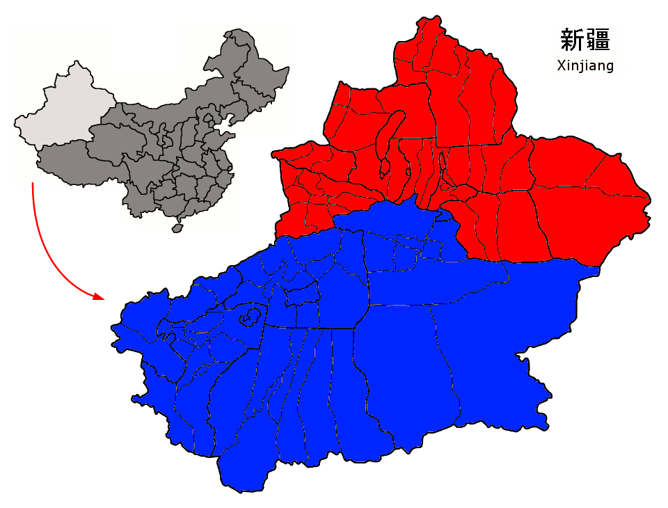
Xinjiang regions simplified
Xinjiang regions simplified Quigley · CC BY-SA 3.0 · Commons

East Turkestan or East Turkistan (Uyghur: شەرقىي تۈركىستان, ULY: Sherqiy Türkistan, UKY: Шәрқий Туркистан) is a loosely defined geographical region in the northwestern part of the People's Republic of China, on the cross roads of East and Central Asia. The term was coined in the 19th century by Russian Turkologists, including Nikita Bichurin, who intended the name to replace the common Western term for the region, "Chinese Turkestan", which referred to the Tarim Basin in Southern Xinjiang.

From Wikipedia: East Turkestan (CC BY-SA 4.0)

Coins, Currency and Symbols

  • Kokbayraq flag
    Kokbayraq flag User:Tarkan · Public domain · Commons

Eastern Moghulistan

1519 CE – 1686 CE · Capital: Almaliq · 938,660 km²

The making of this document was supported by Wikimedia Polska.
The making of this document was supported by Wikimedia Polska. w0zny · CC BY-SA 3.0 · Commons

Moghulistan, also called the Moghul Khanate or the Eastern Chagatai Khanate, was a Turco-Mongol, Muslim, breakaway khanate of the Chagatai Khanate and a historical geographic area north of the Tengri Tagh mountain range, on the border of Central Asia and East Asia. That area today includes parts of Kazakhstan, Kyrgyzstan, and northwest Xinjiang. The khanate nominally ruled over the area from the mid-14th century until the late 17th century.

From Wikipedia: Moghulistan (CC BY-SA 4.0)

Capitals

Wenzhou Road, the pedestrian street in Aksu
Wenzhou Road, the pedestrian street in Aksu Eric Feng · CC BY-SA 2.0 · Commons
Kashgar
Capital
Almaliq
Capital
Turpan
Capital

Rulers

  • Tughluk Timur
  • Ilyas Khoja

Government, Society and Religion

Government
Monarchy
Languages
Middle Mongol (initial period), Turki (Chagatai)
Religion
Sunni Islam, Tengrism

Wars and Battles

Maynila

1521 CE – 1599 CE · Capital: Manila · 4,392 km²

Maynila, also known commonly as Manila and as the Kingdom of Maynila, was a major Tagalog bayan ("country" or "city-state") situated along the modern-day district of Intramuros in the city of Manila, at the southern bank of the Pasig River. It was considered to be one of the most cosmopolitan of the early historic settlements on the Philippine archipelago, fortified with a wooden palisade which was appropriate for the predominant battle tactics of its time. At the northern bank of the river lies the separately-led polity of Tondo.

From Wikipedia: Maynila (historical polity) (CC BY-SA 4.0)

Origins and Founding

Not much is known about when the Tagalog people came to occupy the lands surrounding Manila Bay, but linguists such as Dr. David Zorc and Dr. Robert Blust speculate that the Tagalogs and other Central Philippine ethno-linguistic groups originated in Northeastern Mindanao or the Eastern Visayas. The Tagalog language is believed to have branched out from a hypothesized "proto-language" which linguists have dubbed "Proto-Philippine language," another branch of which was the Visayan languages.

Read more

Some Filipino historians such as Jaime Tiongson have asserted that some of the words used in the Laguna Copperplate Inscription came from Old Tagalog, although the text itself used the Javanese Kawi script.

Like most peoples of Maritime Southeast Asia, the Tagalog people who established the fortified polity of Maynila were Austronesians.

From Wikipedia: Maynila (historical polity) · Prehistory: Tagalog migrations (CC BY-SA 4.0)

Founded
1521 CE

Rulers

  • Salalila
  • Ache

Government, Society and Religion

Portuguese and Spanish records in the 1500s state that Maynila was the same as the kingdom that was referred to as the Kingdom of Luzon (Portuguese: Luçon, possibly from the name "Lusong"), and whose citizens had been called "Luções".

Read more

Magellan expedition member Rodrigo de Aganduru Moriz's account of the events of 1521 specifically describes how the Magellan expedition, then under the command of Sebastian Elcano after the death of Magellan, captured of one of the Luções: Prince Ache, who would later be known as Rajah Matanda, who was then serving as a commander of the Naval forces of Brunei. Aganduru Moriz described the "young prince" as being "the Prince of Luzon - or Manila, which is the same.” corroborated by fellow expedition member Gines de Mafra and the account of expedition scribe Antonio Pigaffetta.

From Wikipedia: Maynila (historical polity) · Government and politics: Maynila as the Kingdom of Luzon (CC BY-SA 4.0)

Government
Absolute Monarchy
Languages
Old Tagalog, Malay
Religion
Islam, Hinduised Tagalog polytheism

Economy and Trade

Historians widely agree that the larger coastal polities which flourished throughout the Philippine archipelago in the period immediately prior to the arrival of the Spanish colonizers (including Tondo and Maynila) were "organizationally complex", demonstrating both economic specialization and a level of social stratification which would have led to a local demand for "prestige goods".

Read more

were already using gunpowder weapons, the more famous people of the Shogunate of Japan were still using Samurai swords and bow and arrows.

Junker notes that significant work still needs to be done in analyzing the internal/local supply and demand dynamics in pre-Spanish era polities, because much of the prior research has tended to focus on their external trading activities.

From Wikipedia: Maynila (historical polity) · Economy (CC BY-SA 4.0)

Coins, Currency and Symbols

Currency
Gold coin

Wars and Battles

According to the account of Rajah Matanda as recalled by Magellan expedition members Gines de Mafra, Rodrigo de Aganduru Moriz, and expedition scribe Antonio Pigafetta, Rajah Matanda's father (whose name was not mentioned in the accounts) died when he was still very young. Rajah Matanda's mother (also unnamed in the Spanish accounts) then became the paramount ruler of the Maynila polity. In the meantime, Rajah Matanda, then simply known as the "Young Prince" Ache, was raised alongside his cousin, who was ruler of Tondo, although not specifically named in the Spanish accounts.

Read more

During this time, Ache realized that his cousin, who was ruler of Tondo, was "slyly", taking advantage of Ache's mother, by taking over territory belonging to Maynila. When Ache asked his mother for permission to address the matter, his mother refused, encouraging the young prince to keep his peace instead.

From Wikipedia: Maynila (historical polity) · History: Territorial conflicts with Tondo (before 1521) (CC BY-SA 4.0)

Achievements and Monuments

One specific exception to the predominance of Anitism in early Tondo and Maynila was that the apex-level leaders of these polities identified themselves as Muslims, as did the migrant sailor Luzones who were encountered by early 15th century chroniclers in Portuguese Malacca. However, the various ethnographic reports of the period indicate that this seemed to only be a nominal identification ("Muslim by name") because there was only a surface level acknowledgement of Muslim norms (avoidance of pork, non-consumption of blood, etc.) without an "understanding of Mohammedan teachings." Scholars generally believe that this nominal practice of Islam actually represented the early stages of Islamization, which would have seen a much more extensive practice of Muslim beliefs had the Spanish not arrived and introduced their brand of Iberian Catholicism.

From Wikipedia: Maynila (historical polity) · Culture and society: Coexistence with and syncretistic adaptation from other beliefs (CC BY-SA 4.0)

Legacy in the Modern World

Maynila, along with Tondo, was a prosperous trading settlement by the 16th century, ruled by Bruneian aristocrats intermarried with the Tagalog elite. The ruling class were fluent in both Malay and Tagalog, and many of the people in Maynila were literate, compared to those of the Visayas. It was because of this relationship that the Tagalog language used in Maynila began absorbing Malay words into their own vocabulary. Somewhere in the early 16th century, the ruler of Maynila, Rajah Salalila or Panguiran Salalila, was married to a daughter of Sultan Bolkiah and princess Puteri Laila Menchanai of Sulu. Apart from ruling over Maynila, Panguiran Salalila was also acknowledged by the chiefs of Mindoro to be their overlord.

From Wikipedia: Maynila (historical polity) · History: Influence of Brunei (early 16th century) (CC BY-SA 4.0)

Tümed

1547 CE – 1699 CE · 2,616,320 km²

The Tümed are a Mongol subgroup. Tümed Mongols mainly live in the region around the city of Hohhot, such as Tumed Left Banner and Tumed Right Banner (in Baotou) in China. Most engage in sedentary agriculture in mixed communities. Another Tümed group live in Chaoyang, Liaoning. There are a small number of Tümeds in Ömnögovi Aimag, Mongolia. From the beginning of the 9th century to the beginning of the 13th century, the Khori-Tumed lived near the western side of Lake Baikal. They lived in what is now southern Irkutsk Oblast, in some parts of Tuva and in southwestern Buryatia.

From Wikipedia: Tumed (CC BY-SA 4.0)

Government, Society and Religion

Languages
West Tümed: West Tümed-Ordos dialect of Mongolian; many speak Jin Chinese, East Tümed: Kharchin dialect (Tümed subdialect) of Mongolian
Religion
Tibetan Buddhism, Shamanism

Dutch Republic

1582 CE – 1795 CE · Capital: None (de jure), The Hague (de facto) · 646,020 km²

Smiling Girl, a Courtesan, Holding an Obscene Image title QS:P1476,en:"Smiling Girl, a Courtesan, Holding an Obscene Image "label QS:Len,"Smiling Girl, a Courtesan, Holding an Obscene Image "label QS:Les,"Mujer joven…
Smiling Girl, a Courtesan, Holding an Obscene Image title QS:P1476,en:"Smiling Girl, a Courtesan, Holding an Obscene Image "label QS:Len,"Smiling Girl, a Courtesan, Holding an Obscene Image "label QS:Les,"Mujer joven… Gerard van Honthorst · Public domain · Commons

The Republic of the Seven United Netherlands, also known as the United Provinces, and referred to in historiography as the Dutch Republic, was a confederation and great power that existed from 1588 until the Batavian Revolution in 1795. It was a predecessor state of the present-day Netherlands and the first independent Dutch nation state.

From Wikipedia: Dutch Republic (CC BY-SA 4.0)

Rulers

Government, Society and Religion

There was an eighth province, the County of Drenthe (corresponding to the modern province of Drenthe), but this area was so poor that it was exempt from paying federal taxes, and as a consequence, it was denied representation in the States General, which is why the official name of the state was the "Seven United Netherlands" and not the "Eight United Netherlands".

Read more

Each province was governed by the Provincial States, their main executive official (though not the official head of state) being a raadpensionaris or landsadvocaat. In times of war, the stadtholder, who commanded the army, would have more power than the raadpensionaris. In theory, the stadtholders were freely appointed by and subordinate to the states of each province.

From Wikipedia: Dutch Republic · Politics (CC BY-SA 4.0)

Government
Confederal parliamentary republic
Languages
Dutch, Dutch Low Saxon, West Frisian
Religion
Dutch Reformed (state religion), Catholicism, Judaism, Lutheranism

Economy and Trade

During the Dutch Golden Age in the late-16th and 17th centuries, the Dutch Republic dominated world trade, conquering a vast colonial empire and operating the largest fleet of merchantmen of any nation. When Southern Europe was experiencing poor harvests, the Dutch very profitably exported surplus grain from Poland. The County of Holland was the wealthiest and most urbanized region in the world. In 1650 the urban population of the Dutch Republic as a percentage of total population was 31.7 percent, while that of the Spanish Netherlands was 20.8 percent, of Portugal 16.6 percent, and of Italy 14 percent. In 1675 the urban population density of Holland alone was 61 percent, compared to the rest of the Dutch Republic, where 27 percent lived in urban areas.

Read more

The free trade spirit of the time was augmented by the development of a modern, effective stock market in the Low Countries.

From Wikipedia: Dutch Republic · Economy (CC BY-SA 4.0)

Coins, Currency and Symbols

Nederlandse rijksdaalder Utrecht 1668
Nederlandse rijksdaalder Utrecht 1668 Schulman bv · CC BY-SA 4.0 · Commons
Currency
Reichsthaler, Dutch guilder
  • Nederlandse gulden uit 1967, beeltenis van Koningin Juliana
    Nederlandse gulden uit 1967, beeltenis van Koningin Juliana Marion Golsteijn · CC BY-SA 3.0 · Commons
  • W - 28.34 g. D - 42 mm.
    W - 28.34 g. D - 42 mm. DmVlKam · CC BY-SA 4.0 · Commons
  • Bekendmaking van de chef-staf van het Militair Gezag betreffende de geldcirculatie en -sanering, maart 1945.
    Bekendmaking van de chef-staf van het Militair Gezag betreffende de geldcirculatie en -sanering, maart 1945. Unknown authorUnknown author · Public domain · Commons
  • Statenvlag
    Statenvlag Dr. Feelgood · Public domain · Commons
  • Coat of arms of the republic of the united Netherlands
    Coat of arms of the republic of the united Netherlands Unknown authorUnknown author , design is 18th century. · Public domain · Commons

Wars and Battles

The year 1672 is known in the Netherlands as the "Disaster Year" (Rampjaar). England declared war on the Republic, (the Third Anglo-Dutch War), followed by France, Münster and Cologne, which had all signed alliances against the Republic. France, Cologne and Münster invaded the Republic. Johan de Witt and his brother Cornelis, who had accomplished a diplomatic balancing act for a long time, were now the obvious scapegoats. They were lynched, and a new stadtholder, William III, was appointed.

Read more

An Anglo-French attempt to land on the Dutch shore was barely repelled in three desperate naval battles under command of Admiral Michiel de Ruyter. The advance of French troops from the south was halted by a costly inundation of its own heartland, by breaching river dikes.

From Wikipedia: Dutch Republic · History: Franco-Dutch War and Third Anglo-Dutch War (1672–1702) (CC BY-SA 4.0)

Achievements and Monuments

Dutch culture also declined both in the arts and sciences. Literature for example largely imitated English and French styles with little in the way of innovation or originality. The most influential intellectual was Pierre Bayle (1647–1706), a Protestant refugee from France who settled in Rotterdam where he wrote the massive Dictionnaire Historique et Critique (Historical and Critical Dictionary, 1696). It had a major impact on the thinking of The Enlightenment across Europe, giving an arsenal of weapons to critics who wanted to attack religion. It was an encyclopaedia of ideas that argued that most "truths" were merely opinions, and that gullibility and stubbornness were prevalent.

Read more

Religious life became more relaxed as well. Catholics grew from 18% to 23% of the population during the 18th century and enjoyed greater tolerance, even as they continued to be outside the political system.

From Wikipedia: Dutch Republic · History: Culture and society (CC BY-SA 4.0)

Decline and Fall

Battle of the Nile, August 1st 1798 at 10 pm
Battle of the Nile, August 1st 1798 at 10 pm Thomas Luny · Public domain · Commons

Long-term rivalry between the two main factions in Dutch society, the Staatsgezinden (Republicans, Dutch States Party) and the Prinsgezinden (Royalists or Orangists), sapped the strength and unity of the country. Johan de Witt and the Republicans did reign supreme for a time at the middle of the 17th century (the First Stadtholderless Period) until his overthrow and murder in 1672. Subsequently, William III of Orange became stadtholder. After a 22-year stadtholderless era, the Orangists regained power, and his first problem was to survive the Franco-Dutch War (with the derivative Third Anglo-Dutch War), when France, England, Münster, and Cologne united against his country.

Read more

Wars to contain the expansionist policies of France in various coalitions after the Glorious Revolution burdened the republic with huge debts, although little of the fighting after 1673 took place on Dutch territory.

From Wikipedia: Dutch Republic · Decline (CC BY-SA 4.0)

Ended
1795 CE

Khoshut Khanate

1582 CE – 1695 CE · Capital: Lhasa · 291,729 km²

Lhasa from Potala
Lhasa from Potala Unknown author · CC BY-SA 3.0 · Commons

The Khoshut Khanate was a Mongol Oirat khanate based in the Tibetan Plateau from 1642 to 1717. Based in modern Qinghai, it was founded by Güshi Khan in 1642 after defeating the opponents of the Gelug school of Tibetan Buddhism in Tibet. The 5th Dalai Lama established a civil administration known as Ganden Phodrang with the aid of Güshi Khan. The role of the khanate in the affairs of Tibet has been subject to various interpretations.

From Wikipedia: Khoshut Khanate (CC BY-SA 4.0)

Rulers

Government, Society and Religion

Government
Nomadic empire
Religion
Tibetan Buddhism

Later Jin Dynasty

1619 CE – 1644 CE · Capital: Shenyang · 2,516,284 km²

Qing Dynasty Anonymous "Statue of the Emperor's Destiny of the Qing Dynasty"
Qing Dynasty Anonymous "Statue of the Emperor's Destiny of the Qing Dynasty" Unknown authorUnknown author · Public domain · Commons

The Later Jin, officially known as Jin or the Great Jin, was a Jurchen-led royal dynasty of China and a khanate ruled by the House of Aisin-Gioro in Manchuria, as the precursor to the Qing dynasty. Established in 1616 by the Jianzhou Jurchen chieftain Nurhaci upon his reunification of the Jurchen tribes, its name was derived from the earlier Jin dynasty founded by the Wanyan clan which had ruled northern China in the 12th and 13th centuries. In 1635, the lingering Northern Yuan dynasty under Ejei Khan formally submitted to the Later Jin.

From Wikipedia: Later Jin (1616–1636) (CC BY-SA 4.0)

Origins and Founding

The Jurchen people had traditionally lived in Manchuria and were then divided into three tribes, the most powerful of which during the Ming dynasty was called Jianzhou Jurchens, living around the Changbai Mountains. In order to attack and suppress the Northern Yuan dynasty, the Hongwu Emperor sent military commissions to gain control of the Jurchen tribes in Manchuria. The Ming government divided the Jianzhou Jurchens into three wei (a military subdivision during the Ming dynasty), collectively known as the "Three Wei of Jianzhou". The leaders of the Jurchen tribes were usually chosen as commanders of the wei.

Read more

The northern tribe Wild Jurchens were strong at that time, and attacked the Jianzhou Jurchens. Mengtemu, commander of the Jianzhou Wei, was killed. The Jianzhou Jurchens were forced to move southwards, and finally settled at Hetu Ala.

From Wikipedia: Later Jin (1616–1636) · History: Rise of Jianzhou Jurchens (CC BY-SA 4.0)

Founder
Nurhaci
Founded
1619 CE

Rulers

Government, Society and Religion

Government
Absolute monarchy
Languages
Jurchen (renamed Manchu after 1635), Mongolian, Chinese (Classical and Mandarin)

Coins, Currency and Symbols

Currency
Chinese coin, Chinese cash

Decline and Fall

Ended
1644 CE
Succeeded by
Qing dynasty

Li Zicheng

1632 CE – 1644 CE · 407,378 km²

Li Zicheng (22 September 1606 – 1645), born Li Hongji, also known as the Dashing King (Chuang Wang), was a Chinese rebel leader who helped overthrow the Ming dynasty in April 1644. He claimed the imperial throne as the Yongchang Emperor of the Shun dynasty, which controlled much of North China for a short period. He died a year later. Born into an impoverished family in Shaanxi, Li became involved in the growing peasant rebellions during the late Ming period around 1630.

From Wikipedia: Li Zicheng (CC BY-SA 4.0)

Southern Ming

1645 CE – 1682 CE · Capital: Yingtian (1644–1645), Tianxing (1645–1646), Guangzhou (1646), Zhaoqing (1646) · 2,179,980 km²

Nanjing CBD from City Wall
Nanjing CBD from City Wall xiquinhosilva · CC BY 2.0 · Commons

The Southern Ming, also known in historiography as the Later Ming, officially the Great Ming, was an imperial dynasty of China and a series of rump states of the Ming dynasty that came into existence following the Jiashen Incident of 1644. Peasant rebels led by Li Zicheng who founded the short-lived Shun dynasty captured Beijing and the Chongzhen Emperor committed suicide. The Ming general Wu Sangui then opened the gates of the Shanhai Pass in the eastern section of the Great Wall to the Qing banners, in hope of using them to annihilate the Shun forces.

From Wikipedia: Southern Ming (CC BY-SA 4.0)

Origins and Founding

The fall of the Ming and the Qing conquest that followed was a period of catastrophic war and population decline in China. China experienced a period of extremely cold weather from the 1620s until the 1710s. Some modern scholars link the worldwide drop in temperature at this time to the Maunder Minimum, an extended period from 1645 to 1715 when sunspots were absent. Whatever the cause, the change in the climate reduced agricultural yields and cut state revenue. It also led to drought, which displaced many peasants. There were a series of peasant revolts in the late Ming, culminating in a revolt led by Li Zicheng which captured Beijing in 1644.

Read more

Ming ideology emphasized authoritarian and centralized administration, referred to as "imperial supremacy" or huángjí. However, comprehensive central decision-making was beyond the technology of the time.

From Wikipedia: Southern Ming · Background (CC BY-SA 4.0)

Founded
1645 CE
Preceded by
Ming dynasty

Rulers

  • Hongguang Emperor
  • Longwu Emperor

Government, Society and Religion

Government
Monarchy

Wars and Battles

Decline and Fall

Ended
1682 CE
Succeeded by
Qing dynasty

Early Modern States of China: Frequently Asked Questions

Which states existed in China in this period?

This page maps 9 states of China founded between 1463 CE and 1645 CE: East Turkestan, Eastern Moghulistan, Maynila, Tümed, Dutch Republic, Khoshut Khanate, Later Jin Dynasty, Li Zicheng, Southern Ming.

Which was the largest of the Early Modern States of China?

Tümed had the largest mapped extent, about 2,616,320 km².

Which of the Early Modern States of China lasted longest?

Dutch Republic lasted longest, 1582 CE – 1795 CE.

Sources

  • Reading text: Wikipedia articles on the group and each state, condensed (CC BY-SA 4.0).
  • Facts, rulers and wars: Wikidata (CC0).
  • Borders: Cliopatria, Seshat Global History Databank (CC BY 4.0).
  • Pictures: Wikimedia Commons; the author and licence are under each picture.

Largest state by mapped extent: Tümed.