Skip to content
YearMaps
9 states1463 CE – 1910 CE

Early Modern States of West Africa: Map & History

9 states of West Africa on one map, from 1463 CE to 1910 CE.The largest, Songhai Empire, covered about 665,730 km²; the longest-lived, Wadai Empire, lasted 1636 CE – 1910 CE. Each has its own section below with its rulers, capitals, wars and pictures where the records hold them.

Tomb of Askia, Gao
David Sessoms from Fribourg, Switzerland · CC BY-SA 2.0 · Commons
Palace of Alaafin of Oyo circa mid-1900s
The African History · Public domain · Commons
Abéché, Tchad
Dans · CC BY-SA 3.0 · Commons
Jan Luyken - Goudkust
Jan Luyken · Public domain · Commons
Base map
1463 AD
1789 AD
1910 AD
1463 AD
1575 AD
1675 AD
1800 AD
1910 AD
Epochs:
↗
↗
↗
↗
↗
↗
↗
↗

Each state in its own colour. Move the timeline to see which existed in any year from 1463 AD to 1910; select a territory to read about it. Borders: Cliopatria / Seshat (CC BY 4.0).

The Early Modern States of West Africa Compared

StateYearsCapitalLargest extentRulers
Songhai Empire1463 CE – 1608 CEGao665,730 km²1
Portuguese Africa1507 CE – 1581 CE–35,685 km²–
Oyo Empire1609 CE – 1835 CEOyo-Igboho (c. 1300–1615), Oyo-Ile (c. 1615–1835)87,978 km²2
Wadai Empire1636 CE – 1910 CEAbéché279,943 km²1
Dutch Gold Coast1653 CE – 1872 CEFort Nassau (1612–1637), Fort Elmina (1637–1872)15,701 km²–
Danish Gold Coast1659 CE – 1852 CEFort Christiansborg (1658-1850)1,349 km²2
Ashanti Empire1702 CE – 1897 CEKumasi186,800 km²4
Bamana Empire1713 CE – 1821 CESégou104,716 km²1
Freetown Colony1788 CE – 1796 CE–3,430 km²–

Timeline of the Early Modern States of West Africa

When each state existed, 1463 CE to 1910 CE. Select a year to see the map then.

  1. Songhai Empire
    1463 CE – 1608 CE
  2. Portuguese Africa
    1507 CE – 1581 CE
  3. Oyo Empire
    1609 CE – 1835 CE
  4. Wadai Empire
    1636 CE – 1910 CE
  5. Dutch Gold Coast
    1653 CE – 1872 CE
  6. Danish Gold Coast
    1659 CE – 1852 CE
  7. Ashanti Empire
    1702 CE – 1897 CE
  8. Bamana Empire
    1713 CE – 1821 CE
  9. Freetown Colony
    1788 CE – 1796 CE

The 9 States

Songhai Empire

1463 CE – 1608 CE · Capital: Gao · 665,730 km²

Tomb of Askia, Gao
Tomb of Askia, Gao David Sessoms from Fribourg, Switzerland · CC BY-SA 2.0 · Commons

The Songhai Empire was a state located in the western part of the Sahel during the 15th and 16th centuries. At its peak, it was one of the largest African empires in history. The state is known by its historiographical name, derived from its largest ethnic group and ruling elite, the Songhai people. Sonni Ali established Gao as the empire's capital, although a Songhai state had existed in and around Gao since the 11th century. Other important cities in the kingdom were Timbuktu and Djenné, where urban-centred trade flourished; they were conquered in 1468 and 1475, respectively.

From Wikipedia: Songhai Empire (CC BY-SA 4.0)

Origins and Founding

Founded
1463 CE
Preceded by
Gao Empire

Rulers

Government, Society and Religion

The kurma, where the Balama, the minister of defence of the empire and general-in-chief of the armies in charge of military surveillance of the western provinces, including Mali, was based. The western garrisons were stationed there, and the Balama resided with part of the naval fleet in the port of Kabara. The other important personality was the Kurma Fari, who acted as governor and lived in Timbuktu, the provincial capital.

Read more

The capital city of Gao, where the emperor resided with the central garrisons and part of the fleet commanded by the Hikoy, the admiral of the empire stationed at the port of Gao with more than a thousand ships at its height. It was wheremost large-scale military campaigns started.

From Wikipedia: Songhai Empire · Organization (CC BY-SA 4.0)

Government
monarchy
Languages
Songhay

Coins, Currency and Symbols

Seashell radiology: Cypraea
Seashell radiology: Cypraea This illustration was made by (User:Royonx) and released under the license(s) stated above. · CC BY-SA 3.0 · Commons
Currency
cowrie currency

Wars and Battles

The Songhai armed forces included a navy led by a hikoy (admiral), a cavalry of mounted archers, an infantry, and a camel cavalry. They trained herds of long-horned bulls in the imperial stables to charge at the enemy in battle. Vultures were also used to harass opposing camps.

Read more

The Songhai included three military provinces, and an army was stationed in each. It was divided into several garrisons, the kurmina, led by the balama, the central province by the emperor himself and the dendi by the dendi fari. The army of the closest military province was mobilized with that of the emperor. Those remaining on the spot ensured order in the three provinces; the emperor was obliged to be in front of the armed during a war of conquest. The Jinakoy ruled secondary provinces and their lieutenants in the regions of the provinces.

From Wikipedia: Songhai Empire · Military (CC BY-SA 4.0)

Achievements and Monuments

Overland trade in the Sahel and river trade along the Niger were the primary sources of Songhai wealth. Trade along the West African coast was only possible in the late 1400s. Several dikes were constructed during the reign of Sonni Ali, which enhanced the irrigation and agricultural yield of the empire.

Read more

Overland trade was influenced by four factors: camels, Berber tribe members, Islam, and the structure of the empire. Gold was readily available in West Africa, but salt was not, so the gold-salt trade was the backbone of overland trade routes in the Sahel. Ivory, ostrich feathers, and slaves were sent north in exchange for salt, horses, camels, cloth, and art. While many trade routes were used, the Songhai heavily used the way through the Fezzan via Bilma, Agades, and Gao.

The Niger River was essential to trade for the empire.

From Wikipedia: Songhai Empire · Culture: Economy (CC BY-SA 4.0)

Decline and Fall

In 1528, Askia's children revolted against him, declaring his son Askia Musa king. Following Musa's overthrow in 1531, the Songhai Empire went into decline. Following the death of Emperor Askia Daoud in 1583, a war of succession weakened the Songhai Empire and split it into two feuding factions.

Read more

During this period, Moroccan armies annihilated a Portuguese invasion at the Battle of Alcácer Quibir, but were left on the verge of economic depletion and bankruptcy, as they needed to pay for the defences used to hold off the siege. This led Sultan Ahmad I al-Mansur of the Saadi dynasty in 1591 to dispatch an invasion force south under the eunuch Judar Pasha. The Moroccan invasion of Songhai was mainly to seize and revive the trans-Saharan trade in salt, gold and slaves for their developing sugar industry.

From Wikipedia: Songhai Empire · History: Decline and Saadian Invasion (CC BY-SA 4.0)

Ended
1608 CE

Portuguese Africa

1507 CE – 1581 CE · 35,685 km²

Portuguese Africa is mapped in the atlas for 1507 CE – 1581 CE, with a peak mapped extent of about 35,685 km².

Oyo Empire

1609 CE – 1835 CE · Capital: Oyo-Igboho (c. 1300–1615), Oyo-Ile (c. 1615–1835) · 87,978 km²

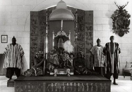
Palace of Alaafin of Oyo circa mid-1900s
Palace of Alaafin of Oyo circa mid-1900s The African History · Public domain · Commons

The Oyo Empire was a Yoruba empire in West Africa. It was located in present-day western Nigeria (including the South West zone and the western half of the North Central zone) and Benin. It grew to become the largest Yoruba-speaking state through the organizational and administrative efforts of the Yoruba people, trade, as well as the military use of cavalry.

From Wikipedia: Oyo Empire (CC BY-SA 4.0)

Origins and Founding

The legendary origins of the Oyo Empire lie with Ọranyan (also known as Ọranmiyan), the last prince of the Yoruba Kingdom of Ile-Ife (Ife). According to oral traditions, Ọranmiyan made an agreement with his brother to launch a punitive raid on their northern neighbors for insulting their father Oduduwa, the first Ooni of Ife. On the way to the battle, the brothers quarreled and the army split up. Oranmiyan's force was too small to make a successful attack, so he wandered the southern shore of the Niger River until reaching Bussa. There, the local chief entertained him and provided a large snake with a magic charm attached to its throat.

Read more

The chief instructed Oranmiyan to follow the snake until it stopped somewhere for seven days and disappeared into the ground. Oranmiyan followed the advice and founded Oyo where the serpent stopped. The site is remembered as Ajaka.

From Wikipedia: Oyo Empire · History: Legend of origin (CC BY-SA 4.0)

Founded
1609 CE

Rulers

  • Ọranyan
  • Adeyemi I Alowolodu

Government, Society and Religion

The Oyo Mesi were the seven principal councilors of the state. They constituted the Electoral Council and possessed legislative powers. Led by the Bashorun, acting as prime minister, and consisting of the Agbaakin, the Samu, the Alapini, the Laguna, the Akiniku, and the Ashipa, they represented the voice of the nation and had the chief responsibility of protecting the interests of the empire. The Alaafin was required to take counsel from them whenever any important matter affecting the state occurred. Each chief had a state duty to perform at court every morning and afternoon. Each also had a deputy whom they would send to the Alaafin if their absence was unavoidable. The Oyo Mesi developed as a check on the Alaafin's power, preventing the Alaafin from being an autocrat; they compelled many Alaafins to commit suicide during the 17th and 18th centuries.

From Wikipedia: Oyo Empire · Political structure: Oyo Mesi (CC BY-SA 4.0)

Government
Constitutional Hereditary Monarchy with Elective features.
Languages
Yoruba
Religion
Yoruba religion, Islam

Economy and Trade

In the late eighteenth century, Oyo came to rely too much on the trading of slaves with Europeans, so that when the trade was outlawed, Oyo suffered a loss of revenue and authority. This allowed many tributary states, such as Dahomey, to rebel and exert their own independence, at Oyo's expense. Oyo also became a target of the Fulani Jihad of 1804, which established the Sokoto Caliphate and caused frequent clashes with Oyo. This caused the Oyo Empire to fall into chaos and suffer a massive loss in territory, power, and influence. As a result, Yoruba people fell victim to the slave raids of neighbouring states, like Dahomey and Sokoto. This caused a wave of Yoruba captives to enter the Atlantic Slave Trade during the first half of the nineteenth century.

From Wikipedia: Oyo Empire · History: Atlantic Slave Trade (CC BY-SA 4.0)

Wars and Battles

The Oyo Empire was one of the only Yoruba states to adopt cavalry; it did so because most of its territory was in the northern savannah. The origin of the cavalry is unclear; however, the Nupe, Borgu and Hausa in neighbouring territories also used cavalry and may have had the same historical source. Oyo was able to purchase horses from the north and maintain them in metropolitan Oyo because of partial freedom from the tsetse fly. Cavalry was the long arm of the Oyo Empire. Late 16th and 17th century expeditions were composed entirely of cavalry. There were drawbacks to this. Oyo could not maintain its cavalry army in the south but could raid at will. Despite its drawbacks, Oyo Empire amassed a cavalry force exceeding 100,000 horsemen, with a contingent of that size reportedly mobilized specifically for campaigns against the Kingdom of Dahomey.

From Wikipedia: Oyo Empire · Military: Cavalry (CC BY-SA 4.0)

Achievements and Monuments

The architecture within the Oyo Empire, exhibited an intricate built environment. Elite residences in Oyo-Ile showcased a distinctive architectural style, highlighted by intricate sculptures that symbolized the status of the inhabitants. Sculptors adorned houses and compounds with finely carved wooden posts and bas-relief doors, often depicting narratives of significant events, asserting power, and immortalizing the experiences of the residents. However, the most intricate and elaborate architectural artworks were reserved for the temples dedicated to the deities. An exceptional example is the temple of Sango. The structure, perfectly square and approximately twenty yards on each side, featured polished, deep-red stained floors and walls. Hugh Clapperton called it "The largest and most fancifully ornamented of any of a similar kind in the interior of Africa."

From Wikipedia: Oyo Empire · Culture: Architecture (CC BY-SA 4.0)

Decline and Fall

Many believe the decline of the Oyo empire had started as early as 1754 with the dynastic intrigues and palace coups sponsored by the Oyo Prime Minister Gaha. In his quest for absolute power, Gaha conspired with the Oyo Mesi and probably to some extent the Ogboni to force four successive Alaafins to commit ritual suicide after they had been presented with the symbolic parrot's eggs. Between June and October 1754 alone, two Alaafins had been forced to commit suicide by Gaha. Because of this, Alaafin Awonbioju spent 130 days on the throne, while Alaafin Labisi only spent 17 days on the throne. Gaha's treachery was not ended until 1774 during the reign of Alaafin Abiodun, the fifth Alaafin he served. Gaha was subsequently executed by Abiodun but the instability that had been brought about by these intrigues had further weakened Oyo.

From Wikipedia: Oyo Empire · History: Decline (CC BY-SA 4.0)

Ended
1835 CE

Wadai Empire

1636 CE – 1910 CE · Capital: Abéché · 279,943 km²

Abéché, Tchad
Abéché, Tchad Dans · CC BY-SA 3.0 · Commons

The Wadai Sultanate or Wadai Empire (1635–1912) was an African sultanate located to the east of Lake Chad in present-day Chad and the Central African Republic. It emerged in the seventeenth century under the leadership of the first sultan, Abd al-Karim, who overthrew the ruling Tunjur people of the area. It bordered the Sultanate of Darfur and the Sultanate of Baguirmi. Despite there being an abundancy of sources available on the sultanate, a comprehensive historical study is yet to be undertaken about Wadai.

From Wikipedia: Wadai Sultanate (CC BY-SA 4.0)

Origins and Founding

Prior to the 1630s, the region was ruled by the Tunjur kingdom, established around the 15th century. Tunjur oral traditions say that the founder of the Tunjur kingdom in Darfur, Ahmad al-Ma'qur, had two sons called Ahmad Kanjar and Musa; Kanjar accordingly succeeded his father in Darfur and was the founder of the Kunjaara dynasty, while Musa went to Wadai and subjugated the region with the assistance of the Mahamid Arabs. McGregor wrote that many of the early heroes in tradition were later Islamised to strengthen the ruling dynasty's legitimacy.

Read more

In 1635, the Maba and other small groups in the region rallied to the Islamic banner of Abd al-Karim, who was descended from the Maba tribe noble family, and overthrew the ruling Tunjur dynasty, who at the time was led by a king named "Daud".

From Wikipedia: Wadai Sultanate · History: Origins (CC BY-SA 4.0)

Founded
1636 CE

Rulers

Government, Society and Religion

Government
Monarchy
Languages
Maba, Chadian Arabic, Tunjur, Fur
Religion
Islam (official), Traditional African religion

Wars and Battles

Under Abd al-Karim Sabun in the early 19th century, Wadai forces were equipped with chain mail and firearms. In the 1840s–50s, Wadai possessed 300 guns. The figure went upwards to 4000 flintlock muskets by the 1870s. Sultan Ali (1858–1874) hired Turkish and Egyptian mechanics to cast 12 bronze and small caliber cannons. These cannons lacked carriages and Gustav Nachtigal concluded in the 19th century that they were ineffective.

Read more

Wadai could deploy about 5–6000 cavalry of which a third of the cavalry men wore quilted armor whiles several more wore steel armor. Infantry could amount up to 56–60,000. The army was divided into two wings and a centre with the Sultan located behind the centre. The Sultan was protected by shield bearers who bore iron shields as well as "the troop of path makers" who cleared way for the Sultan's mobility through the bush.

From Wikipedia: Wadai Sultanate · Military (CC BY-SA 4.0)

Decline and Fall

In 1898, Ali Dinar re-established the Darfur Sultanate at the same time as Sultan Yusuf's death, allowing him to interfere in the succession dispute. Darfur's candidate, Ahmad al-Ghazali, was crowned. Al-Ghazali was assassinated and replaced by the Senussi's candidate, Muhammad Salih (Yusuf's son), known as "Dud Murra" ("the lion of Murra"). He repaid the Senussi by allowing their merchants to trade freely. Rabih az-Zubayr conducted raids into Wadai. In 1906, the French initiated aggressive hostilities against Wadai, proposing Adam Asil as their puppet candidate. France invaded, and in 1909 they took Abéché. Dud Murra escaped to Kapka under the Senussi and Asil was made sultan. The French went on to conquer Wadai's vassals. Dud Murra continued to fight the French until his final defeat in 1910.

From Wikipedia: Wadai Sultanate · History: Decline (CC BY-SA 4.0)

Ended
1910 CE

Dutch Gold Coast

1653 CE – 1872 CE · Capital: Fort Nassau (1612–1637), Fort Elmina (1637–1872) · 15,701 km²

Jan Luyken - Goudkust
Jan Luyken - Goudkust Jan Luyken · Public domain · Commons

The Dutch Gold Coast or Dutch Guinea, officially Dutch possessions on the Coast of Guinea (Dutch: Nederlandse Bezittingen ter Kuste van Guinea), was a portion of contemporary Ghana known as the Gold Coast (Dutch: Goudkust), that from 1612 was gradually colonised by the Dutch West India Company (WIC) from the Dutch and Batavian Republics (present-day Kingdom of the Netherlands). The Dutch began trading in the area around 1598, joining the Portuguese which had a trading post there since the late 15th century.

From Wikipedia: Dutch Gold Coast (CC BY-SA 4.0)

Government, Society and Religion

After the liquidation of the WIC in 1791, the Council of Colonies for the West Indies took over the government of the Dutch Gold Coast. Little changed in the first years, and the old administration of the WIC was left largely intact.

Read more

This changed when the Batavian Republic replaced the Dutch Republic in 1795. The administration of the Dutch Gold Coast was reformed by a secret resolution of 12 May 1801. The office of Director-General was renamed Governor-General, and the council was split in a Great Council and a Small Council. The Small Council was responsible for the everyday government of the colony, and comprised the Governor-General, the administrator-and-Director-General (Dutch: administrateur en directeur-generaal),Note 1 the master of stores, the master of works, and the bookkeeper of the general office (Dutch: boekhouder ten comptoir-generaal).

From Wikipedia: Dutch Gold Coast · Administration: Direct Dutch rule (CC BY-SA 4.0)

Languages
Dutch
Religion
Dutch Reformed

Economy and Trade

Although the colony is nowadays primarily associated with Atlantic slave trade, this was not the reason for the first Dutch traders to trade with the Gold Coast. Barent Eriksz made a profit trading gold, ivory, and West African pepper, and these products remained the primary trading goods in the early 17th century. According to Joannes de Laet, the WIC had transported West African goods worth 14 million Dutch guilders to the Dutch Republic by 1637, of which the most important was the trade in gold.

Read more

This changed with the gradual capture of Brazil from the Portuguese, from 1630 onward. Suddenly, the trade of slaves, for which there was no significant market earlier, became a necessity for the economic survival of Dutch Brazil. Nicolas van Yperen, Governor of the Dutch possessions on the Gold Coast, was instructed by his superiors of the WIC to supply Dutch Brazil with slaves.

From Wikipedia: Dutch Gold Coast · Economy (CC BY-SA 4.0)

Coins, Currency and Symbols

Currency
Dutch guilder
  • Flag of the Dutch West India Company
    Flag of the Dutch West India Company Flag_of_the_Dutch_West_India_Company.png: *Flag_of_the_Netherlands.svg: Zscout370 derivative work: Fentener van Vlissingen (talk) derivative work: Mnmazur (talk · Public domain · Commons
  • Monogram WIC
    Monogram WIC Desconocido · CC BY-SA 4.0 · Commons

Wars and Battles

In the remainder of the 19th century, the Dutch Gold Coast slowly fell into disarray. The only substantial development during this period was the recruitment of soldiers for the Dutch East Indies Army. This recruitment of the so-called Belanda Hitam (Indonesian for "Black Dutchmen") started in 1831 as an emergency measure as the Dutch army lost thousands of European soldiers and a much larger number of "native" soldiers in the Java War (1825–1830), and at the same time saw its own population base diminished by the independence of Belgium (1830). As the Dutch wanted the number of natives in the Dutch East Indies Army to be limited to roughly half the total strength to maintain the loyalty of native forces, the addition of forces from the Gold Coast seemed an ideal opportunity to keep the army at strength and loyal at the same time.

From Wikipedia: Dutch Gold Coast · History: Recruitment of soldiers for the Dutch East Indies Army (CC BY-SA 4.0)

Legacy in the Modern World

After the Dutch East Indies gained independence as Indonesia in 1949, most Belanda Hitam migrated to the Netherlands, since they had been soldiers of the Royal Netherlands East Indies Army. Other than that, the Dutch colonial history on the Gold Coast was more or less forgotten. This changed slightly after Arthur Japin published the earlier mentioned The Two Hearts of Kwasi Boachi in 1997. This attention also revealed that the head of Ahanta king Badu Bonsu II, taken to the Netherlands after his execution in 1838, was still in the possession of the Leiden University Medical Centre. The head of the king was handed over to the Ghanaian ambassador in a ceremony held on 23 July 2009 in The Hague.

From Wikipedia: Dutch Gold Coast · Legacy (CC BY-SA 4.0)

Danish Gold Coast

1659 CE – 1852 CE · Capital: Fort Christiansborg (1658-1850) · 1,349 km²

ChristiansborgCastle
ChristiansborgCastle Unknown author · Public domain · Commons

The Danish Gold Coast (Danish: Danske Guldkyst or Dansk Guinea) comprised the colonies that Denmark–Norway controlled in Africa as a part of the Gold Coast (roughly present-day southeast Ghana), which is on the Gulf of Guinea. It was colonized by the Dano-Norwegian fleet, first under indirect rule by the Danish West India Company (a chartered company), later as a crown colony of the kingdom of Denmark-Norway. The area under Danish influence was over 10,000 square kilometres, with an estimated population of approximately 40,000 in 1837.

From Wikipedia: Danish Gold Coast (CC BY-SA 4.0)

Origins and Founding

An opportunity to for the Danes to establish themselves on the Gold Coast and eject the Swedes appeared in the person of Hendrik Carloff, a former employee of the Swedish Africa Company. After being accused by the Swedes of conducting unauthorized private commerce and weakened by the death of his patron Louis de Geer resigned from Swedish service in 1656 and left the country. When hostilities erupted between Denmark and Sweden, he turned to the Danish crown and, in August 1657, obtained a letter of marque empowering him to capture Fort Carlsborg and attack Swedish interests in Guinea at his own cost.

Read more

Under this agreement, Carloff was granted broad autonomy: he could capture Swedish ships, keep most of the proceeds, and dispose of former Swedish forts himself the Danish King wished not to keep them. He sailed from Glückstadt in December 1657 and reached the Gold Coast in January 1658.

From Wikipedia: Danish Gold Coast · History: Early years (1658-1665) (CC BY-SA 4.0)

Founded
1659 CE

Rulers

  • Frederick III of Denmark-Norway (first)
  • Frederick VII of Denmark (last)

Government, Society and Religion

Languages
Danish, German (official), Ga, Dangme, Ewe, Akan

Economy and Trade

The Danes were involved in the slave trade from the mid-17th century until the early 19th century. The Royal Danish Navy and its mercantile marine were recorded as the fourth largest in Europe in this period. With the establishment of the Gold Coast colony in the 1660s, commodities such as gold and ivory dominated at first, but by the turn of the 18th century, slaves were the most important commodity in the Danish trade. Those who commanded the large slave ships were often instructed to convert their cabin into a kind of moveable showroom upon arrival on the African coast. While throughout the 18th century, Danish exports of enslaved Africans accounted for about 5 percent of the total exports from the Gold Coast, by the 1780s, this was up to 10 percent.

From Wikipedia: Danish Gold Coast · History: Danish slave trade (CC BY-SA 4.0)

Coins, Currency and Symbols

Currency
Danish rigsdaler
  • Flag of Denmark
    Flag of Denmark Madden and others · Public domain · Commons
  • National coat of arms of Denmark
    National coat of arms of Denmark Unknown author · CC BY-SA 3.0 · Commons

Ashanti Empire

1702 CE – 1897 CE · Capital: Kumasi · 186,800 km²

Ambassador Palmer made her first visit to Kumasi from September 29-30, 2022 to meet local leaders, engage U.S. government exchange alumni, and hear from entrepreneurs about their challenges and opportunities.
Ambassador Palmer made her first visit to Kumasi from September 29-30, 2022 to meet local leaders, engage U.S. government exchange alumni, and hear from entrepreneurs about their challenges and opportunities. U.S. Embassy Ghana · Public domain · Commons

The Asante Empire (Asante Twi: Asanteman), also known as the Ashanti Empire, was an Akan state that lasted from 1701 to 1902, in what is now modern-day Ghana. It expanded from the Ashanti Region to include most of Ghana and also parts of Ivory Coast and Togo. Due to the empire's military prowess, wealth, architecture, sophisticated hierarchy, trade networks and culture, the Asante Empire has been extensively studied and has more historic records written by European, primarily British, authors than any other indigenous culture of sub-Saharan Africa.

From Wikipedia: Asante Empire (CC BY-SA 4.0)

Origins and Founding

In Akan oral tradition, Adanse is the place where Odomankoma (God) began the creation of the word. It is also associated with the beginnings of Akan kingship and the abusua (clan) system. Adansemanso, the first capital of Adanse, was continuously occupied from the 9th century CE, with earlier settlement dating to 393 CE. Excavations revealed that the town reached its largest size between the 13th and 15th centuries.

Read more

According to Osei Tutu Agyeman Prempeh II, the Adanse were the most powerful and advanced of the early Akan groups and were remembered for establishing the first organized kingship in the region. Many southern Akan regarded the region as their ancestral homeland, as well as the origin of many ruling lineages. The Agona of Denkyira originally lived the area stretching from Asokwa west of Obuase and Akrofuom to the meeting of the Oda and Ofin rivers.

From Wikipedia: Asante Empire · History: Adanse and the formation of Akan states (CC BY-SA 4.0)

Founded
1702 CE

Rulers

Government, Society and Religion

Okomfo Anokye was responsible for creating the Seventy-Seven Laws of Komfo Anokye which served as the codified constitution of the Ashanti Empire.

Read more

The Asante state, in effect, was a theocracy. It invokes religious, rather than secular-legal postulates. What the modern state views as crimes, Ashanti view practically as sins. Antisocial acts disrespect the ancestors, and are only secondarily harmful to the community. If the chief or King fails to punish such acts, he invokes the anger of the ancestors and the gods, and is therefore in danger of impeachment. The penalty for some crimes (sins) is death, but this is seldom imposed; a more common penalty is banishment or imprisonment. The King typically exacts or commutes all capital cases.

From Wikipedia: Asante Empire · Legal system (CC BY-SA 4.0)

Government
Constitutional elective monarchy
Languages
Asante (Twi) (official), Hausa, Dyula
Religion
Akan religion

Economy and Trade

Infrastructure throughout the empire included a network of well-kept roads from the Asante mainland to the Niger river and other trade cities. Stationed at various points of Asante roads were the Nkwansrafo or road wardens who served as the highway police; checking the movement of traders and strangers on all roads. They were also responsible for scouting and were charged with the collection of tolls from traders.

Read more

...some stout, forked sticks or posts are driven in the centre of the stream at convenient distances, across which are placed some strong beams, fastened to the posts with withes, from the numerous climbing plants on every hand. On these bearers are placed long stout poles which are covered with earth from fourth to six inches thick; and this completes the bridge.

From Wikipedia: Asante Empire · Economy: Infrastructure (CC BY-SA 4.0)

Coins, Currency and Symbols

Currency
Gold dust

Wars and Battles

In 1721 and 1722, Asante decided to attack Aowin, Nzima and Wassa in order to secure the western trade routes. During the campaigns, the Asante fought many battles against Aowin and Nzima, which ended in their total defeat. The Dutch reported that “the gold rich Awinse suffered its greatest defeat,” and that large numbers of Aowin prisoners were sold as slaves at Elmina, Cape Coast and Anomabo. John Atkins, a British naval officer on the Nzima coast at the time, recorded that he personally met the Queen of Nzima and her followers who had fled their country at Assini. After defeating Aowin and Nzima, the Asante intended to extend the campaign into Wassa territory, but hostilities were temporarily halted because Tekyiman threatened an invasion of Asante. In 1722, Bono was conquered by subterfuge using Bafo Pim and the Nkoronzas.

From Wikipedia: Asante Empire · History: War against Aowin, Nzima, Wassa, Bono, Gyaman, Gonja, Krakye and Dagomba (CC BY-SA 4.0)

Achievements and Monuments

Slavery was practiced in the Asante Empire, with slaves typically taken as captives from enemies in warfare. The Asante Empire was the largest slaveowning and slave trading state in the territory of today's Ghana during the Atlantic slave trade. The welfare of their slaves varied from being able to acquire wealth and intermarry with the master's family to being sacrificed in funeral ceremonies. The Asante believed that slaves would follow their masters into the afterlife. Slaves could sometimes own other slaves, and could also request a new master if the slave believed he or she was being severely mistreated.

Read more

The modern-day Asante claim that slaves were seldom abused, and that a person who abused a slave was held in high contempt by society. They defend the "humanity" of Asante slavery by noting that those slaves were allowed to marry.

From Wikipedia: Asante Empire · Culture and society: Slavery (CC BY-SA 4.0)

Decline and Fall

After suppressing Denkyira resistance, Asante turned its attention to the west in order to secure control of the trade routes linking the forest states with the northern markets and the coast. Wenchi and neighboring states occupied important positions along routes leading toward Nsoko (Begho). Ahwene Koko was the capital of the Wenchi state and became a target during these campaigns. According to Wenchi traditions, Osei Tutu attacked Ahwene Koko in order to obtain the “precious Ahenedwa (red bead stool)” of the Wenchi ruler. Wenchi was a wealthy trading state and the polity benefited from access to kola and alluvial gold and was also known for its cloth industry. A Dutch map of 1629 described Wenchi as producing “artistically beautiful cloths which the inhabitants sell to the Akani.”

From Wikipedia: Asante Empire · History: The fall of Wenchi and war with Aowin (CC BY-SA 4.0)

Ended
1897 CE

Bamana Empire

1713 CE – 1821 CE · Capital: Ségou · 104,716 km²

From the main road that welcomes you to Segou to the T-junction that leads to Mopti, this roundabout stands as a monument
From the main road that welcomes you to Segou to the T-junction that leads to Mopti, this roundabout stands as a monument Lyfengine · CC BY-SA 4.0 · Commons

The Ségou Empire (also Bambara or Bamana Empire, Bambara: ߓߊ߲ߓߊߙߊ߲߫ ߝߊ߯ߡߟߊ, romanized: Banbaran Fāmala) was one of the largest states of West Africa in the 18th century. Along with Kaarta it was one of the most important successors of the Songhai Empire. Based on an earlier kingdom established in 1640, it grew into a powerful empire in the early 18th century under Bitòn Coulibaly. The empire existed as a centralized state from 1712 until the 1861 invasion by the Toucouleur conqueror El Hadj Umar Tall.

From Wikipedia: Ségou Empire (CC BY-SA 4.0)

Rulers

Government, Society and Religion

The Segou Empire was structured around traditional Bambara institutions. The most important of these was the ton, or age-group. They were in theory completely egalitarian and elected their own leaders. Through charisma and ruthless power politics, however, Biton converted this into essentially an army made up of forobadjon (nominally, slaves of the community) led by tondjons, or slaves of the ton but who were in practice a military aristocracy. Any faama strong enough to control the tondjons was in effect an absolute monarch, doling out state property as rewards for bravery. A 40-man council of state swore allegiance and obedience to him and served as a rubber stamp. Relatives were given key posts, and the faama was the head priest of powerful and important religious cults.

From Wikipedia: Ségou Empire · Government (CC BY-SA 4.0)

Government
Monarchy
Languages
Bambara
Religion
Animism, Islam

Economy and Trade

The economy of the Segou Empire flourished through trade, especially that of the slaves captured in their many wars. One category of slave, the jonfin, could be sold; another, the jonba were put to work by the state either as laborers or as soldiers in the ton djon. The demand for slaves then led to further fighting, leaving the Bambara in a perpetual state of war with their neighbors, and slaves from the area formed the majority of those sold to European traders at the Senegal River and Gambia River trading posts.

Read more

Trade was conducted largely by Muslim maraka merchants who traded across the Sahara or towards the coast. They exchanged guns, shell money, horses, salt, gold, cloth, and slaves.

From Wikipedia: Ségou Empire · Economy (CC BY-SA 4.0)

Coins, Currency and Symbols

Currency
cowries, mithqal

Wars and Battles

Decline and Fall

At the Battle of Noukouma in 1818, Bambara forces met and were defeated by Fula Muslim fighters rallied by the jihad of Cheikou Amadu (or Seku Amadu) of Massina. The Segou Empire survived but was irreversibly weakened. Seku Amadu's forces decisively defeated the Bambara, taking Djenné and much of the territory around Mopti and forming into a Massina Empire. Timbuktu would fall as well in 1845.

Read more

After 1839 the faamaw succeeded each other in rapid fashion as the tonjon leaders grew increasingly powerful, independent, and prone to intervene in succession disputes. When El Hadj Umar Tall, a Toucouleur religious leader, declared a jihad against the empire in 1859, this balkanization prevented 'faama' Ali from mounting an effective defense. Tall took Nyamina without a fight on May 25, 1860, then defeated the Bamana army at Witala in September.

From Wikipedia: Ségou Empire · History: Jihad and fall (CC BY-SA 4.0)

Ended
1821 CE

Freetown Colony

1788 CE – 1796 CE · 3,430 km²

Aerial view of Freetown, Sierra Leone, a helicopter expedition to Lungii airport, over the Freetown Harbour.
Aerial view of Freetown, Sierra Leone, a helicopter expedition to Lungii airport, over the Freetown Harbour. David Hond · CC BY 2.0 · Commons

Freetown (Krio: Fritɔun) is the capital and largest city of Sierra Leone. It is a major port city on the Atlantic Ocean and is located in the Western Area of the country. Freetown is Sierra Leone's major urban, economic, financial, cultural, educational and political centre, as it is the seat of the Government of Sierra Leone. The population of Freetown was 1,347,559 as of the 2024 census. The city's economy revolves largely around its harbour, which occupies a part of the estuary of the Sierra Leone River in one of the world's largest natural deep water harbours.

From Wikipedia: Freetown (CC BY-SA 4.0)

Origins and Founding

Founder
John Clarkson
Founded
1788 CE

Government, Society and Religion

The city of Freetown is one of Sierra Leone's six municipalities and is governed by a directly elected city council, headed by a mayor, in whom executive authority is vested. The current mayor is Yvonne Aki-Sawyerr. The mayor is responsible for the general management of the city. The mayor and members of the Freetown City Council are elected directly by the residents of Freetown every four years.

Read more

The government of the Freetown Municipality has been dominated by All People's Congress (APC) since 2004. Since 2004, the residents of Freetown have voted in municipal elections for members of the All People's Congress (APC) by an overwhelming majority. The APC won the city's mayorship and vast majority seats in the Freetown city council in the 2004, 2008, 2012 and 2018 local elections by more than 67% each.

From Wikipedia: Freetown · Government (CC BY-SA 4.0)

Government
City council
Languages
Krio, English

Economy and Trade

Freetown is the economic and financial centre of Sierra Leone. The country's state television and radio station, the Sierra Leone Broadcasting Corporation, is primarily based in Freetown. The other national broadcasters, such as AYV (African Young Voices) and Capital Radio, are also based in Freetown. Many of the national headquarters of the country's largest corporations, as well as the majority of international companies, are located in Freetown - predominately in Central Freetown.

Read more

The city's economy revolves largely around its natural harbour, which is the largest natural harbour on the African continent. Queen Elizabeth II Quay is capable of receiving oceangoing vessels and handles Sierra Leone's main exports.

Industries include food and beverage processing, fish packing, rice milling, petroleum refining, diamond cutting, and the manufacture of cigarettes, paint, textile, and beer.

From Wikipedia: Freetown · Economy (CC BY-SA 4.0)

Coins, Currency and Symbols

Wars and Battles

The city was the scene of fierce fighting in the late 1990s during the Sierra Leone Civil War. It was captured by ECOWAS troops seeking to restore President Ahmad Tejan Kabbah in 1998. Later it was unsuccessfully attacked by rebels of the Revolutionary United Front.

From Wikipedia: Freetown · History: Civil war, 1990s to early 2000s (CC BY-SA 4.0)

Achievements and Monuments

The city has the Sierra Leone National Museum and Sierra Leone National Railway Museum. There are also various historical landmarks connected to its founding by African Americans, Liberated Africans, and Afro-Caribbeans whose descendants are the Sierra Leone Creole people. The Cotton Tree represents the christening of Freetown in March 1792. In downtown Freetown is the Connaught Hospital, the first hospital constructed in West Africa that incorporated Western medical practices.

Read more

Freetown has a long-held tradition of organized cultural events taking place on specific dates to coincide with specific holidays or seasons within the calendar year.

From Wikipedia: Freetown · Culture (CC BY-SA 4.0)

Early Modern States of West Africa: Frequently Asked Questions

Which states existed in West Africa in this period?

This page maps 9 states of West Africa founded between 1463 CE and 1788 CE: Songhai Empire, Portuguese Africa, Oyo Empire, Wadai Empire, Dutch Gold Coast, Danish Gold Coast, Ashanti Empire, Bamana Empire, Freetown Colony.

Which was the largest of the Early Modern States of West Africa?

Songhai Empire had the largest mapped extent, about 665,730 km².

Which of the Early Modern States of West Africa lasted longest?

Wadai Empire lasted longest, 1636 CE – 1910 CE.

Sources

  • Reading text: Wikipedia articles on the group and each state, condensed (CC BY-SA 4.0).
  • Facts, rulers and wars: Wikidata (CC0).
  • Borders: Cliopatria, Seshat Global History Databank (CC BY 4.0).
  • Pictures: Wikimedia Commons; the author and licence are under each picture.

Largest state by mapped extent: Songhai Empire.