Skip to content
YearMaps
6 states850 CE – 1894 CE

Medieval and Early Modern States of North America: Map & History

6 states of North America on one map, from 850 CE to 1894 CE.The largest, Haudenosaunee, covered about 570,383 km². Each has its own section below with its rulers, capitals, wars and pictures where the records hold them.

1914 - Buffalo New York, Panoramic View of Iroquois. CREDIT: "Iroquois Indians." c1914. William Alexander Drennan, copyright claimant, 1914. Taking the Long View: Panoramic Photographs, 1851-1991, Library of Congress.
Uploaded to EN wiki by Chris 73 · Public domain · Commons
Buildings and Roads of Old Quebec City, Quebec, Canada
Fabian Roudra Baroi · CC BY-SA 4.0 · Commons
Monument erected at the site of the first landing on the banks of the Christina River designed by Swedish sculptor Carl Milles
Jerrye & Roy Klotz MD · CC BY-SA 3.0 · Commons
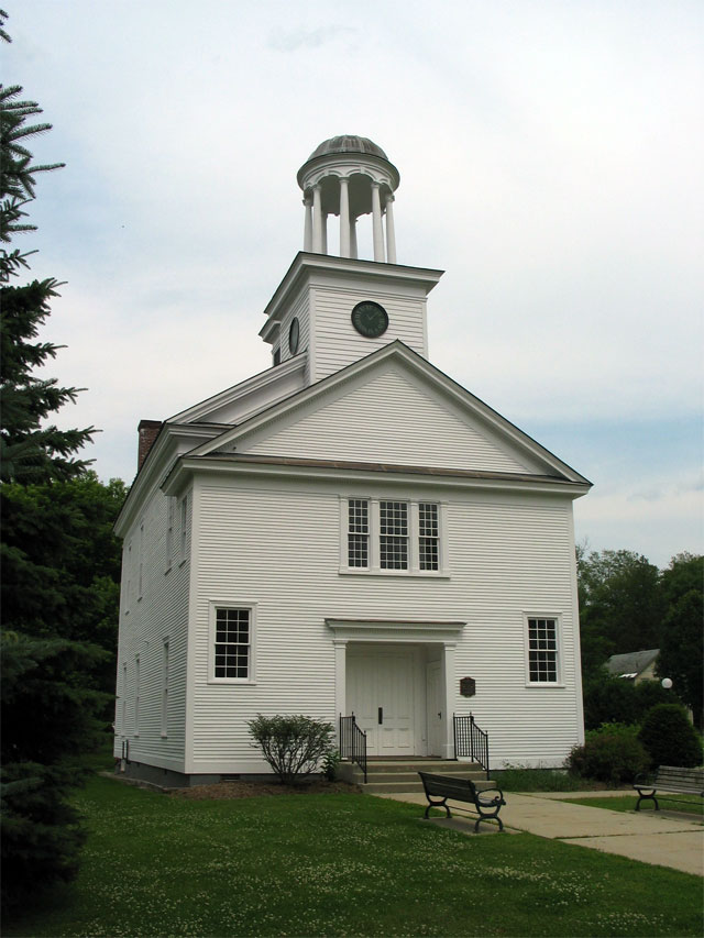
Windsor, Vermont, viewed from the south
Ascended Dreamer · CC BY-SA 4.0 · Commons
Base map
850 AD
1640 AD
1894 AD
850 AD
1100 AD
1300 AD
1500 AD
1700 AD
1894 AD
Epochs:
↗
↗
↗
↗
↗
↗
↗
↗

Each state in its own colour. Move the timeline to see which existed in any year from 850 AD to 1894; select a territory to read about it. Borders: Cliopatria / Seshat (CC BY 4.0).

The Medieval and Early Modern States of North America Compared

StateYearsCapitalLargest extentRulers
Puebloans - Chaco Regional System850 CE – 1151 CE–64,974 km²–
Haudenosaunee1450 CE – 1782 CEOnondaga570,383 km²1
New France1609 CE – 1791 CEQuebec249,127 km²2
New Sweden1640 CE – 1658 CEFort Christina2,841 km²2
Vermont Republic1783 CE – 1790 CEWestminster (1777), Windsor (1777–1784), Castleton (1784–1791)28,159 km²2
Kingdom of Hawaï'i1791 CE – 1894 CEWaikīkī / Honolulu / Kailua-Kona (following the movements of Kamehameha I (1795–1820), Lāhainā (1820–1845), Honolulu (1845–1893)24,850 km²5

Timeline of the Medieval and Early Modern States of North America

When each state existed, 850 CE to 1894 CE. Select a year to see the map then.

  1. Puebloans - Chaco Regional System
    850 CE – 1151 CE
  2. Haudenosaunee
    1450 CE – 1782 CE
  3. New France
    1609 CE – 1791 CE
  4. New Sweden
    1640 CE – 1658 CE
  5. Vermont Republic
    1783 CE – 1790 CE
  6. Kingdom of Hawaï'i
    1791 CE – 1894 CE

The 6 States

Puebloans - Chaco Regional System

850 CE – 1151 CE · 64,974 km²

The Ancestral Puebloans, also known as Ancestral Pueblo peoples or the Basketmaker-Pueblo culture, were an ancient Native American culture of Pueblo peoples spanning the present-day Four Corners region of the United States, comprising southeastern Utah, northeastern Arizona, northwestern New Mexico, and southwestern Colorado. They are believed to have developed, at least in part, from the Oshara tradition, which developed from the Picosa culture.

From Wikipedia: Ancestral Puebloans (CC BY-SA 4.0)

Origins and Founding

Founded
850 CE
Preceded by
Oshara Tradition

Wars and Battles

Environmental stress may have caused changes in social structure, leading to conflict and warfare. Near Kayenta, Arizona, Jonathan Haas of the Field Museum in Chicago has been studying a group of Ancestral Puebloan villages that relocated from the canyons to the high mesa tops during the late 13th century. Haas believes that the reason to move so far from water and arable land was a defense against enemies. He asserts that isolated communities relied on raiding for food and supplies, and that internal conflict and warfare became common in the 13th century.

From Wikipedia: Ancestral Puebloans · History: Warfare (CC BY-SA 4.0)

Achievements and Monuments

The Ancestral Puebloan culture is perhaps best known for the stone and earth dwellings its people built along cliff walls, particularly during the Pueblo II and Pueblo III eras, from about 900 to 1350 CE in total. The best-preserved examples of the stone dwellings are now protected within United States' national parks, such as Navajo National Monument, Chaco Culture National Historical Park, Mesa Verde National Park, Canyons of the Ancients National Monument, Aztec Ruins National Monument, Bandelier National Monument, Hovenweep National Monument, and Canyon de Chelly National Monument.

Read more

These villages, called pueblos by Spanish colonists, were accessible only by rope or through rock climbing. These astonishing building achievements had modest beginnings. The first Ancestral Puebloan homes and villages were based on the pit-house, a common feature in the Basketmaker periods.

From Wikipedia: Ancestral Puebloans · Cultural characteristics (CC BY-SA 4.0)

Haudenosaunee

1450 CE – 1782 CE · Capital: Onondaga · 570,383 km²

1914 - Buffalo New York, Panoramic View of Iroquois. CREDIT: "Iroquois Indians." c1914. William Alexander Drennan, copyright claimant, 1914. Taking the Long View: Panoramic Photographs, 1851-1991, Library of Congress.
1914 - Buffalo New York, Panoramic View of Iroquois. CREDIT: "Iroquois Indians." c1914. William Alexander Drennan, copyright claimant, 1914. Taking the Long View: Panoramic Photographs, 1851-1991, Library of Congress. Uploaded to EN wiki by Chris 73 · Public domain · Commons

The Haudenosaunee Confederacy (HOH-din-oh-SHOH-nee; lit. 'those who build the longhouse'), also known as the Iroquois, is a confederacy of Iroquoian Indigenous peoples in northeast North America. They have also been called the Six Nations (Five Nations before 1722). The Haudenosaunee originally comprised (from east to west) the Mohawk, Oneida, Onondaga, Cayuga, and Seneca peoples. After 1722, the Iroquoian-speaking Tuscarora migrated from the southeast and were accepted into the Confederacy.

From Wikipedia: Haudenosaunee (CC BY-SA 4.0)

Origins and Founding

Hiawatha
Hiawatha Augustus Saint-Gaudens · CC BY-SA 3.0 · Commons

The Haudenosaunee League was established prior to European contact, with the banding together of five Iroquoian peoples living south of the Great Lakes into "The Great League of Peace". Many archaeologists and anthropologists believe that the League was formed about 1450, though arguments have been made for dates as early as the solar eclipse of August 31, 1142.

Read more

The founders of the League are traditionally held to be Dekanawida the Great Peacemaker, Hiawatha, and Jigonhsasee the Mother of Nations, whose home acted as a sort of United Nations. They brought the Peacemaker's Great Law of Peace to the five Iroquoian nations who were fighting, raiding, and feuding with each other and with other tribes, both Algonkian and Iroquoian. From east to west, the League was composed of the Mohawk, Oneida, Onondaga, Cayuga, and Seneca nations.

From Wikipedia: Haudenosaunee · History: Formation of the League (CC BY-SA 4.0)

Founders
Hiawatha, Great Peacemaker, Jigonhsasee
Founded
1450 CE

Rulers

  • Sid Hill

Government, Society and Religion

Historians in the 20th century have suggested the Haudenosaunee system of government influenced the development of the U.S. government, although the extent and nature of this influence has been disputed. Bruce Johansen proposes that the Haudenosaunee had a representative form of government.

Read more

Consensus has not been reached on how influential the Haudenosaunee model was to the development of U.S. documents such as the Articles of Confederation and the U.S. Constitution. The influence thesis has been discussed by historians such as Donald Grinde and Bruce Johansen. In 1987, Cornell University held a conference on the link between the Haudenosaunee's government and the U.S. Constitution. In 1988, the U.S. Congress passed a resolution to recognize the influence of the Haudenosaunee League upon the Constitution and Bill of Rights.

Scholars such as Jack N. Rakove challenge this thesis.

From Wikipedia: Haudenosaunee · Government: Influence on the United States (CC BY-SA 4.0)

Government
Confederation with consensus government
Languages
Iroquoian languages, English
Religion
Protestantism, Catholicism, Longhouse Religion

Coins, Currency and Symbols

  • Flag of the Iroquois Confederacy
    Flag of the Iroquois Confederacy Rick Hill, Harold Johnson, and Tim Johnson · Public domain · Commons
  • Haudenosaunee seal
    Haudenosaunee seal Unknown authorUnknown author · Public domain · Commons

Wars and Battles

During World War I, Canada encouraged First Nations men to enlist in the Canadian Expeditionary Force (CEF), where their hunting skills made them excellent snipers and scouts, particularly the warlike Haudenosee and the especially fierce Mohawk. About half the 4,000 or so First Nations men who served in the CEF were Haudenosaunee. Men from the Six Nations reserve at Brantford were encouraged to join the 114th Haldimand Battalion (Brock's Rangers) of the CEF, where two entire companies including officers were all Haudenosaunee. The 114th Battalion was formed in December 1915, and broken up in November 1916 to provide reinforcements for other battalions.

From Wikipedia: Haudenosaunee · History: World War I (CC BY-SA 4.0)

New France

1609 CE – 1791 CE · Capital: Quebec · 249,127 km²

Buildings and Roads of Old Quebec City, Quebec, Canada
Buildings and Roads of Old Quebec City, Quebec, Canada Fabian Roudra Baroi · CC BY-SA 4.0 · Commons

New France was the territory colonized by France in mainland North America, beginning with the exploration of the Gulf of Saint Lawrence by Jacques Cartier in 1534 and ending with the cession of New France to Great Britain and Spain in 1763 under the Treaty of Paris.

From Wikipedia: New France (CC BY-SA 4.0)

Origins and Founding

In 1608, King Henry IV sponsored Pierre Dugua, Sieur de Mons and Samuel de Champlain as founders of the city of Quebec with 28 men. This was the second permanent French settlement in the colony of Canada. Colonization was slow and difficult. Many settlers died early because of harsh weather and diseases. In 1630, there were only 103 colonists living in the settlement, but by 1640, the population had reached 355.

Read more

Champlain allied himself with the Algonquin and Montagnais peoples in the area, who were at war with the Iroquois, as soon as possible. In 1609, Champlain and two French companions accompanied his Algonquin, Montagnais, and Huron allies south from the St. Lawrence Valley to Lake Champlain. He participated decisively in a battle against the Iroquois there, killing two Iroquois chiefs with the first shot of his arquebus.

From Wikipedia: New France · History: Foundation of Quebec City (1608) (CC BY-SA 4.0)

Founded
1609 CE

Rulers

  • Francis I (first)
  • Louis XV (last)

Government, Society and Religion

Before the arrival of European colonists and explorers, First Nations followed a wide array of mostly animistic religions. As of 1607, official support for the first settlement at Port Royal was conditional based on efforts to convert the local First Nations people to Christianity. The French who later settled along the shores of the Saint Lawrence River, specifically Catholics, including a number of Jesuits dedicated to converting the indigenous population; an effort that eventually proved successful.

Read more

Starting from 1627 in Quebec and 1659 in Acadia, all other forms of Christianity other than Roman Catholicism were forbidden to be worshipped or taught in New France and only French-born Roman Catholics were allowed to immigrate.

From Wikipedia: New France · Religion (CC BY-SA 4.0)

Government
absolute monarchy
Languages
French
Religion
Catholic Church
Population
69000

Economy and Trade

According to the staples thesis, the economic development of New France was marked by the emergence of successive economies based on staple commodities, each of which dictated the political and cultural settings of the time. During the 16th and early 17th centuries New France's economy was heavily centered on its Atlantic fisheries. This would change in the later half of the 17th and 18th centuries as French settlement penetrated further into the continental interior. Here French economic interests would shift and concentrate itself on the development of the North American fur trade. It would soon become the new staple good that would strengthen and drive New France's economy, in particular that of Montreal, for the next century.

Read more

The trading post of Ville-Marie, established on the current island of Montreal, quickly became the economic hub for the French fur trade.

From Wikipedia: New France · Fur trade and economy (CC BY-SA 4.0)

Coins, Currency and Symbols

Currency
French livre, New France livre
  • Royal flag of France
    Royal flag of France Oren neu dag (talk) · CC BY-SA 3.0 · Commons
  • Coat of Arms of Kingdom of France
    Coat of Arms of Kingdom of France Royal Coat of Arms of France.svg, Grand Royal Coat of Arms of France.svg: Sodacan derivative work: Sodacan (talk) · CC BY-SA 3.0 · Commons

Wars and Battles

Fort Duquesne, located at the confluence of the Allegheny and Monongahela Rivers at the site of present-day Pittsburgh, Pennsylvania, guarded the most important strategic location in the west at the time of the Seven Years' War. It was built to ensure that the Ohio River valley remained under French control. A small colonial force from Virginia began a fort here, but a French force under Claude-Pierre Pécaudy de Contrecœur drove them off in April 1754. New France claimed this as part of their colony, and the French were anxious to keep the British from encroaching on it. The French built Fort Duquesne here to serve as a military stronghold and as a base for developing trade and strengthening military alliances with the indigenous peoples of the area.

From Wikipedia: New France · Military conflicts: French and Indian War (CC BY-SA 4.0)

Decline and Fall

Ended
1791 CE
Succeeded by
Acadia

New Sweden

1640 CE – 1658 CE · Capital: Fort Christina · 2,841 km²

Monument erected at the site of the first landing on the banks of the Christina River designed by Swedish sculptor Carl Milles
Monument erected at the site of the first landing on the banks of the Christina River designed by Swedish sculptor Carl Milles Jerrye & Roy Klotz MD · CC BY-SA 3.0 · Commons

New Sweden (Swedish: Nya Sverige) was a colony of the Swedish Empire between 1638 and 1655 along the lower reaches of the Delaware River in what is now Delaware, Maryland, New Jersey, and Pennsylvania. Established during the Thirty Years' War when Sweden was a great power, New Sweden was part of the Swedish efforts to colonize the Americas. Settlements were established on both sides of the Delaware River. Fort Christina, located in what is now Wilmington, Delaware, was the first permanent European settlement in the Delaware Valley and was named after Christina, Queen of Sweden.

From Wikipedia: New Sweden (CC BY-SA 4.0)

Rulers

  • Christina
  • Charles X Gustav

Government, Society and Religion

Government
colonialism
Languages
Swedish, Finnish, Munsee, Unami

Coins, Currency and Symbols

Coin token, nominally 1 daler silvermynt 1719 (hoppet). A Swedish copper coin.
Coin token, nominally 1 daler silvermynt 1719 (hoppet). A Swedish copper coin. Daniel78 · CC BY-SA 2.5 · Commons
Currency
Swedish riksdaler
  • Flag of Sweden (1562–1650)
    Flag of Sweden (1562–1650) Original: Odengatan Vector: Kjoonlee · Public domain · Commons

Wars and Battles

In 1651, the Dutch West India Company abandoned Fort Nassau and established Fort Casimir on the west side of the Delaware River a few miles south of Fort Christina. In May 1654, soldiers from New Sweden led by Governor Johan Risingh captured Fort Casimir and renamed it Fort Trinity (Trefaldigheten in Swedish). In November 1654, the directors of the Dutch West India Company ordered the Director-General of New Netherland, Peter Stuyvesant, to "drive" the Swedes from the river.

Read more

In the summer of 1655, Stuyvesant sailed from New Amsterdam to Delaware Bay with 7 ships and 317 soldiers and quickly retook Fort Casimir (Fort Trinity). Stuyvesant then proceeded to besiege Fort Christina which surrendered on September 15, 1655. During the siege, the Dutch plundered houses and killed livestock in the vicinity of the fort.

From Wikipedia: New Sweden · History: Conquest of New Sweden (CC BY-SA 4.0)

Decline and Fall

Ended
1658 CE
Succeeded by
New Amstel

Legacy in the Modern World

The settlers came from all over the Swedish realm and many of them were Finnish-speaking. The proportion of Finns in New Sweden grew especially towards the end of the colony.

Read more

Many of the Finnish-speaking inhabitants of New Sweden did not come directly from Finland, but from the Finnskogen ("Finn forests") of central Sweden. These communities emerged in the late 1500s and early 1600s, when tens of thousands of Savo Finns migrated from Finland to sparsely populated forest regions, especially Värmland and neighboring provinces. Their migration was encouraged during the reigns of Charles IX and Gustavus Adolphus. These Forest Finns practiced slash-and-burn agriculture, which by the 1630s had become a source of conflict with Swedish authorities, who accused them of destroying valuable timber resources.

From Wikipedia: New Sweden · Finnish influence (CC BY-SA 4.0)

Vermont Republic

1783 CE – 1790 CE · Capital: Westminster (1777), Windsor (1777–1784), Castleton (1784–1791) · 28,159 km²

Windsor, Vermont, viewed from the south
Windsor, Vermont, viewed from the south Ascended Dreamer · CC BY-SA 4.0 · Commons

The Vermont Republic, officially known at the time as the State of Vermont, was a de facto, unrecognized independent state in New England that existed from January 15, 1777, to March 4, 1791. The state was founded in January 1777, when delegates from 28 towns met and declared independence from the jurisdictions and land claims of the British colonies of Quebec, New Hampshire, and New York. The republic remained in existence for the next fourteen years, albeit without diplomatic recognition from any foreign power.

From Wikipedia: Vermont Republic (CC BY-SA 4.0)

Origins and Founding

After 1724, the Province of Massachusetts Bay built Fort Dummer near Brattleboro, as well as three other forts along the northern portion of the Connecticut River to protect against raids by Native Americans farther south into Western Massachusetts. After 1749, Benning Wentworth, the Royal Governor of New Hampshire, granted land to anyone in a land-granting scheme designed to enrich himself and his family. After 1763, settlement increased because of easing security concerns after the end of the French and Indian Wars. The Province of New York had made grants of land, often in areas overlapping similar grants made by the Province of New Hampshire; this issue had to be resolved by King George III in 1764, who granted the land to New York, but the area was popularly known as the New Hampshire Grants.

From Wikipedia: Vermont Republic · Background (CC BY-SA 4.0)

Founded
1783 CE

Capitals

Castleton Vermont 20040701
Castleton Vermont 20040701 The original uploader was Redjar at English Wikipedia. · CC BY-SA 3.0 · Commons
Windsor
Capital
Castleton
Capital

Rulers

  • Thomas Chittenden
  • Moses Robinson

Government, Society and Religion

They saw themselves as a distinct region outside the legitimate jurisdiction of New York. Possessing an identifiable population or "a people" entitled them to the same constitutional rights of self-government as other "Peoples" in the American confederacy.

Read more

The Vermont constitution was modeled after the radically democratic constitution of Pennsylvania on the suggestion of Young, who worked with Thomas Paine and others on that 1776 document in Philadelphia.

During its time as an independent state, the government issued its own coinage and currency and operated postal service. The currency was known as the Vermont copper, and its mint was operated by Reuben Harmon in East Rupert from 1785 to 1788. The chief executive of the state was referred to as the governor.

From Wikipedia: Vermont Republic · Constitution and frame of government (CC BY-SA 4.0)

Government
Republic with executive governor
Languages
English, French

Coins, Currency and Symbols

Vermont copper coinage struck, 1785–1786.
Vermont copper coinage struck, 1785–1786. Reuben Harmon · Public domain · Commons
Currency
Vermont copper
  • Flag of the Vermont Republic
    Flag of the Vermont Republic Mysid at en.wikipedia, revised version first uploaded by Lexicon. · Public domain · Commons
  • Seal of Vermont (B&W)
    Seal of Vermont (B&W) Arnaud Ramey (talk) · Public domain · Commons

Wars and Battles

Decline and Fall

Ended
1790 CE
Succeeded by
Vermont

Kingdom of Hawaï'i

1791 CE – 1894 CE · Capital: Waikīkī / Honolulu / Kailua-Kona (following the movements of Kamehameha I (1795–1820), Lāhainā (1820–1845), Honolulu (1845–1893) · 24,850 km²

Views from Diamond Head in Honolulu, Hawaii
Views from Diamond Head in Honolulu, Hawaii Farragutful · CC BY-SA 4.0 · Commons

The Hawaiian Kingdom, also known as the Kingdom of Hawaiʻi (Hawaiian: Ke Aupuni Hawaiʻi [kɛ ɐwˈpuni həˈvɐjʔi]), was an archipelagic country from 1795 to 1893, which eventually encompassed all of the inhabited Hawaiian Islands. It was established in 1795 when Kamehameha I, then Aliʻi nui of Hawaii, conquered the islands of Oʻahu, Maui, Molokaʻi, and Lānaʻi, and unified them under one government. In 1810, the Hawaiian Islands were fully unified when the islands of Kauaʻi and Niʻihau voluntarily joined the Hawaiian Kingdom.

From Wikipedia: Hawaiian Kingdom (CC BY-SA 4.0)

Origins and Founding

Hawaii was originally settled by Polynesian voyagers from the Marquesas Islands or Tahiti. The date of their first arrival is uncertain. Early archaeological studies suggested they may have arrived as early as the 3rd century CE, while more recent analyses suggest that they did not arrive until around 900–1200 CE. The islands were governed as independent chiefdoms.

Read more

In ancient Hawaiʻi, society was divided into multiple classes. Rulers came from the aliʻi class with each island ruled by a separate aliʻi nui. These rulers were believed to come from a hereditary line descended from the first Polynesian, Papa, who became the earth mother goddess of the Hawaiian religion. Captain James Cook was the first European to encounter the Hawaiian Islands, on his Pacific third voyage (1776–1780). He was killed at Kealakekua Bay on Hawaiʻi Island in 1779 in a dispute over the taking of a longboat.

From Wikipedia: Hawaiian Kingdom · History: Origin (CC BY-SA 4.0)

Founded
1791 CE

Capitals

Kona Bay, Hawaii from Mauka. Near Holualoa.
Kona Bay, Hawaii from Mauka. Near Holualoa. Travisthurston · CC BY-SA 3.0 · Commons
Kailua-Kona
1812–1820 CE

Rulers

Government, Society and Religion

When Hawaii operated under an absolute monarchy, federalism was utilised in regional governance. Foreigners within the lands of Hawaii were thought to themselves as unprosecutable, so a unitary state along with a constitutional monarchy replaced the previous system in 1827 to have uniformity across the entire country.

From Wikipedia: Hawaiian Kingdom · Politics and government (CC BY-SA 4.0)

Government
Absolute monarchy (1795–1840), Constitutional monarchy (1840–1893)
Languages
Hawaiian, English
Religion
Hawaiian religion, Church of Hawaii (from 1862)

Economy and Trade

Economic and demographic factors in the 19th century reshaped the islands. Their consolidation opened international trade. Under Kamehameha (1795–1819), sandalwood was exported to China. That led to the introduction of money and trade throughout the islands.

Read more

Following Kamehameha's death, succession was overseen by his principal wife, Kaʻahumanu, who was designated as regent over the new king, Liholiho, who was a minor.

Queen Kaʻahumanu eliminated various prohibitions (kapu) governing women's behavior. She allowed men and women to eat together and women to eat bananas. She also overturned the old religion in favor of Christianity. The missionaries developed a written Hawaiian language. That led to high levels of literacy in Hawaiʻi, above 90 percent in the latter half of the 19th century. Writing aided in the consolidation of government. Written constitutions were developed.

From Wikipedia: Hawaiian Kingdom · Economic, social, and cultural transformation (CC BY-SA 4.0)

Coins, Currency and Symbols

Billete de cien dólares hawaianos
Billete de cien dólares hawaianos Banco del Reino de Hawái · Public domain · Commons
Currency
United States dollar, Hawaiian dollar
  • Flag of Hawaii (1896)
    Flag of Hawaii (1896) FOTW, Clay Moss (PNG), Government of the Republic of Hawaii · Public domain · Commons
  • Royal Coat of Arms of Hawaii
    Royal Coat of Arms of Hawaii Sodacan · CC BY-SA 3.0 · Commons

Wars and Battles

The Hawaiian army and navy developed from the warriors of Kona under Kamehameha I. The army and navy used both traditional canoes and uniforms including helmets made of natural materials and loincloths (called the malo) as well as Western technology such as artillery cannons, muskets and ships and Western-style organization such as military uniforms and a military rank system. European advisors were treated well and became Hawaiian citizens. When Kamehameha died in 1819 he left his son Liholiho a large arsenal with tens of thousands of soldiers and many warships. This helped put down the revolt at Kuamoʻo later in 1819 and Humehume's rebellion on Kauaʻi in 1824.

Read more

The military shrank with the population under the onslaught of disease, so by the end of the Kamehameha dynasty the Hawaiian navy was severely reduced, having a few outdated ships and the army consisted of a few hundred troops.

From Wikipedia: Hawaiian Kingdom · Military (CC BY-SA 4.0)

Medieval and Early Modern States of North America: Frequently Asked Questions

Which states existed in North America in this period?

This page maps 6 states of North America founded between 850 CE and 1791 CE: Puebloans - Chaco Regional System, Haudenosaunee, New France, New Sweden, Vermont Republic, Kingdom of Hawaï'i.

Which was the largest of the Medieval and Early Modern States of North America?

Haudenosaunee had the largest mapped extent, about 570,383 km².

Which of the Medieval and Early Modern States of North America lasted longest?

Haudenosaunee lasted longest, 1450 CE – 1782 CE.

Sources

  • Reading text: Wikipedia articles on the group and each state, condensed (CC BY-SA 4.0).
  • Facts, rulers and wars: Wikidata (CC0).
  • Borders: Cliopatria, Seshat Global History Databank (CC BY 4.0).
  • Pictures: Wikimedia Commons; the author and licence are under each picture.

Largest state by mapped extent: Haudenosaunee.