Skip to content
YearMaps
9 states1800 CE – 2024 CE

Modern States of Maritime Southeast Asia: Map & History

9 states of Maritime Southeast Asia on one map, from 1800 CE to 2024 CE.The largest, Dutch East Indies, covered about 2,023,054 km². Each has its own section below with its rulers, capitals, wars and pictures where the records hold them.

Pieter Merkus (1787-1844). Gouverneur-generaal (1841-44).
After Jan Willem Pieneman · Public domain · Commons
Limestone formations. Malaysia's Perlis Province.
Nicolai Bangsgaard · CC BY 2.0 · Commons
The Sarawak River flowing through the Kuching city centre.
CoolCityCat · CC BY-SA 3.0 · Commons
Sultan Abdullah Mosque Museum, Pekan, Pahang.
Slleong · CC0 · Commons
Base map
1800 AD
1853 AD
2024 AD
1800 AD
1850 AD
1900 AD
1975 AD
2024 AD
Epochs:
↗
↗
↗
↗
↗
↗
↗
↗

Each state in its own colour. Move the timeline to see which existed in any year from 1800 to 2024; select a territory to read about it. Borders: Cliopatria / Seshat (CC BY 4.0).

The Modern States of Maritime Southeast Asia Compared

StateYearsCapitalLargest extentRulers
Dutch East Indies1800 CE – 1949 CEBatavia, (now Jakarta)2,023,054 km²11
Riau-Lingga Sultanate1820 CE – 1856 CETanjungpinang, (Administrative 1824–1900), (Royal and administrative 1900–1911), Daik, (Royal 1824–1900)103,825 km²2
Kedah-Perlis District1842 CE – 1910 CEKangar2,094 km²4
Kingdom of Sarawak1842 CE – 1946 CEKuching128,406 km²2
Pahang Sultanate1853 CE – 1889 CEPekan40,874 km²2
First Spanish Republic1873 CE – 1876 CEMadrid984,999 km²6
Papua New Guinea1946 CE – 2024 CEPort Moresby483,568 km²2
Federation of Malaya1958 CE – 1962 CEKuala Lumpur139,312 km²3
East Timor2006 CE – 2024 CEDili18,567 km²4

Timeline of the Modern States of Maritime Southeast Asia

When each state existed, 1800 CE to 2024 CE. Select a year to see the map then.

  1. Dutch East Indies
    1800 CE – 1949 CE
  2. Riau-Lingga Sultanate
    1820 CE – 1856 CE
  3. Kedah-Perlis District
    1842 CE – 1910 CE
  4. Kingdom of Sarawak
    1842 CE – 1946 CE
  5. Pahang Sultanate
    1853 CE – 1889 CE
  6. First Spanish Republic
    1873 CE – 1876 CE
  7. Papua New Guinea
    1946 CE – 2024 CE
  8. Federation of Malaya
    1958 CE – 1962 CE
  9. East Timor
    2006 CE – 2024 CE

The 9 States

Dutch East Indies

1800 CE – 1949 CE · Capital: Batavia, (now Jakarta) · 2,023,054 km²

Pieter Merkus (1787-1844). Gouverneur-generaal (1841-44).
Pieter Merkus (1787-1844). Gouverneur-generaal (1841-44). After Jan Willem Pieneman · Public domain · Commons

The Dutch East Indies was a colony of the Dutch Empire, established in 1800 when the Batavian Republic took control of the Dutch East India Company. In 1824, Dutch Malacca was ceded to Britain, and is now part of modern Malaysia, with most of the rest becoming Indonesia in August 1945. During the 19th century, Dutch forces fought a series of wars against indigenous states which greatly expanded the Dutch East Indies. Dutch rule reached its greatest territorial extent in the early 20th century with the occupation of Western New Guinea.

From Wikipedia: Dutch East Indies (CC BY-SA 4.0)

Rulers

Government, Society and Religion

Since the VOC era, the highest Dutch authority in the colony resided with the office of the governor-general. During the Dutch East Indies era the governor-general functioned as chief executive president of colonial government and served as commander-in-chief of the colonial army (KNIL). Until 1903 all government officials and organisations were formal agents of the governor-general and were entirely dependent on the central administration of the 'office of the governor-general' for their budgets. Until 1815 the governor-general had the absolute right to ban, censor or restrict any publication in the colony. The so-called exorbitant powers of the governor-general allowed him to exile anyone regarded as subversive and dangerous to peace and order, without involving any Court of Law.

From Wikipedia: Dutch East Indies · Government: Law and administration (CC BY-SA 4.0)

Government
Unitary dependent territory under direct and indirect rule
Languages
Dutch (official), Malay (lingua franca), Indigenous languages, Chinese
Religion
Islam, Christianity, Hinduism, Buddhism, Confucianism, Taoism, Chinese folk religion, Animism/Traditional religion

Economy and Trade

The economic history of the colony was closely related to the economic health of the Netherlands. Despite increasing returns from the Dutch land tax system, Dutch finances had been severely affected by the cost of the Java War and the Padri War, and the Dutch loss of Belgium in 1830 brought the Netherlands to the brink of bankruptcy. In 1830, a new governor-general, Johannes van den Bosch, was appointed to exploit the Indies through Dutch appropriation of its resources. With the Dutch achieving political domination throughout Java for the first time in 1830, it was then possible to introduce an agricultural policy of government-controlled forced cultivation. Termed cultuurstelsel (cultivation system) in Dutch and tanam paksa (forced plantation) in Indonesia, farmers were required to deliver, as a form of tax, fixed amounts of specified crops, such as sugar or coffee.

From Wikipedia: Dutch East Indies · Economy (CC BY-SA 4.0)

Coins, Currency and Symbols

Currency
Netherlands Indies guilder
  • Flag of the Netherlands
    Flag of the Netherlands Zscout370 · Public domain · Commons
  • State coat of arms of the Netherlands
    State coat of arms of the Netherlands Sodacan · CC BY-SA 3.0 · Commons

Wars and Battles

From the arrival of the first Dutch ships in the late 16th century, to the declaration of independence in 1945, Dutch control over the Indonesian archipelago was always tenuous. Although Java was dominated by the Dutch, many areas remained independent throughout much of this time, including Aceh, Bali, Lombok and Borneo. There were numerous wars and disturbances across the archipelago as various indigenous groups resisted efforts to establish Dutch hegemony, which weakened Dutch control and tied up its military forces. Piracy remained a problem until the mid-19th century. Finally, in the early 20th century, imperial dominance was extended across what was to become the territory of modern-day Indonesia.

From Wikipedia: Dutch East Indies · History: Dutch conquests (CC BY-SA 4.0)

Achievements and Monuments

The Dutch school system was extended to Indonesians with the most prestigious schools admitting Dutch children and those of the Indonesian upper class. A second tier of schooling was based on ethnicity with separate schools for Indonesians, Arabs, and Chinese being taught in Dutch and with a Dutch curriculum. Ordinary Indonesians were educated in Malay in Roman alphabet with "link" schools preparing bright Indonesian students for entry into the Dutch-language schools. Vocational schools and programs were set up by the Indies government to train indigenous Indonesians for specific roles in the colonial economy. Chinese and Arabs, officially termed "foreign orientals", could not enrol in either the vocational schools or primary schools.

From Wikipedia: Dutch East Indies · Education (CC BY-SA 4.0)

Decline and Fall

Ended
1949 CE
Last recorded ruler
Alidius Tjarda van Starkenborgh Stachouwer

Legacy in the Modern World

When the Dutch royal family was established in 1815, much of its wealth came from colonial trade.

Read more

Universities such as the Royal Leiden University founded in the 16th century have developed into leading knowledge centres about Southeast Asian and Indonesian studies. Leiden University has produced academics such as Colonial adviser Christiaan Snouck Hurgronje who specialised in native oriental (Indonesian) affairs, and it still has academics who specialise in Indonesian languages and cultures. Leiden University and in particular KITLV are educational and scientific institutions that to this day share both an intellectual and historical interest in Indonesian studies. Other scientific institutions in the Netherlands include the Amsterdam Tropenmuseum, an anthropological museum with massive collections of Indonesian art, culture, ethnography and anthropology.

From Wikipedia: Dutch East Indies · Colonial heritage in the Netherlands (CC BY-SA 4.0)

Riau-Lingga Sultanate

1820 CE – 1856 CE · Capital: Tanjungpinang, (Administrative 1824–1900), (Royal and administrative 1900–1911), Daik, (Royal 1824–1900) · 103,825 km²

Riau-Lingga Sultanate (Jawi: کسلطانن رياوليڠݢ, romanized: Kesultanan Riau-Lingga), also known as the Lingga-Riau Sultanate, Riau Sultanate or Lingga Sultanate was a Malay sultanate that existed from 1824 to 1911, before being dissolved following Dutch intervention. The sultanate came into existence as a result of the partition of the Johor-Riau Sultanate that separated Johor on the Malay Peninsula and the island of Singapore, from the Riau Archipelago.

From Wikipedia: Riau-Lingga Sultanate (CC BY-SA 4.0)

Origins and Founding

The globalisation of the 19th century opened new opportunities for the Riau-Lingga Sultanate. Proximity to cosmopolitan Singapore, just 40 miles away, shaped the political climate of the kingdom, giving Riau Malays an opportunity to familiarise themselves with new ideas from the Middle East. The opening of Suez Canal meant a journey to Mecca via Port Said, Egypt and Singapore could take no more than a fortnight; thus these cities became major ports for the Hajj pilgrimage.

Read more

Inspired by the experience and intellectual progress attained in the Middle East and influenced by the Pan-Islamism brotherhood, the Riau Malay intelligentsia established the Roesidijah (Club) Riouw in 1895.

From Wikipedia: Riau-Lingga Sultanate · History: The rise of nationalism (CC BY-SA 4.0)

Founded
1820 CE

Rulers

  • Abdul Rahman Muazzam Shah
  • Muhammad II

Government, Society and Religion

The viceregal house of Riau claimed to trace their ancestry from the Bugis Royal House in Luwu, Celebes. The Bugis prominence in the region began during the reign of Abdu'l-Jalil Rahmat of Johor-Riau, during the period of turbulence the Sultan was killed by Raja Kecil who claimed that he was an offspring of the late Sultan Mahmud. He later descent as the Sultan of old Johor. The death of Abdul Jalil was witnessed by his son, Sulaiman of Johor-Riau, who later then requested aid from the Bugis of Klang to combat Raja Kecil and his troops. The alliance formed between Sulaiman and the Bugis managed to defeat Raja Kecil off from his throne.

Read more

As the settlement for the debt of honour by Sulaiman of Johor-Riau in 1772, a joint government were structured between the Bugis forces and the nascent community and the native Malays and several political marriage were formed between the two dynasties.

From Wikipedia: Riau-Lingga Sultanate · Government: Yang di-Pertuan Muda (CC BY-SA 4.0)

Government
Monarchy
Languages
Malay
Religion
Sunni Islam

Economy and Trade

Observing the rise of the Islamic Brotherhood that gained momentum in the late 18th century, the Riau-Lingga Sultanate regarded the Ottoman Empire as a protector against non-Muslim colonial powers. In the eyes of the ruling elite of the court, the Ottomans were a source of inspiration and a balancing power between the western powers and Islamic world. The Crimean War fought by the Ottomans was regarded as a struggle of a "Muslim power" against the "Foreigners", Christians, which to a degree corresponded with the struggle faced in Riau-Lingga.

Read more

The status of the Aceh Sultanate as a vassal of the Ottomans, provided a vital precedent for the Riau-Lingga following the deteriorating relationship with the Dutch. The court discussed a possibility to receiving the same status and protection under the Ottomans with the Ottoman consulate-general in Batavia in 1897–1899 Muhammad Kamil Bey.

From Wikipedia: Riau-Lingga Sultanate · Foreign relations and trade: Ottomans (CC BY-SA 4.0)

Achievements and Monuments

A prominent figure in Malay and Indonesian literature in the Riau-Lingga Sultanate was Ali Haji of Riau, born in Selangor and raised in the Royal Court in Penyengat. He was celebrated as a prolific author, poet, historian, legal jurist and linguist. Some of his works are considered the Magna opera of the Malay literature, including Tuhfat al-Nafis ("the Precious Gift"), Kitab Pengetahuan Bahasa ("Book of Language") — the first dictionary in Malay and Gurindam dua belas ("The Twelve Gurindams"). His works played a vital role in the development of the Malay and modern-Indonesian language. He spent most of his life writing and researching the Malay language, history, culture and law.

Read more

The literary culture that flourished in Penyengat was acknowledged by the Johor delegation during their visit in 1868.

From Wikipedia: Riau-Lingga Sultanate · Literature (CC BY-SA 4.0)

Decline and Fall

On 18 May 1905, the Dutch demanded a new agreement with the sultan, stipulating further limits on the powers of the Riau-Lingga Sultanate, requiring that the Dutch flag must be raised higher than the flag of Riau, and specifying that Dutch officials should be given supreme honour in the land. The agreement further stipulated that the Riau-Lingga Sultanate was a mere achazat (Dutch: loan) from the Dutch Government. The agreement was drawn up due to the fact that the appointment of Sultan Abdul Rahman II (1885–1911) had not been made with the consent of the Dutch and he was also clearly against colonial rule.

From Wikipedia: Riau-Lingga Sultanate · History: Dissolution by the Dutch (CC BY-SA 4.0)

Ended
1856 CE

Legacy in the Modern World

The sultanate is widely credited in the development of the Malay and Indonesian language, as various books, literary works and dictionary was contributed in the sultanate. These works formed as the backbone of the modern Indonesian language. Raja Ali Haji, was celebrated for his contribution on the language and honoured as the National Hero of Indonesia in 2004.

From Wikipedia: Riau-Lingga Sultanate · Legacy (CC BY-SA 4.0)

Kedah-Perlis District

1842 CE – 1910 CE · Capital: Kangar · 2,094 km²

Limestone formations. Malaysia's Perlis Province.
Limestone formations. Malaysia's Perlis Province. Nicolai Bangsgaard · CC BY 2.0 · Commons

Perlis (Kedah Malay: Peghelih) is a state of Malaysia on the northwestern coast of Peninsular Malaysia. It is Malaysia's smallest state by area and population. The state borders the Thai provinces of Satun and Songkhla to the north and the Malaysian state of Kedah to the south. Perlis is the only Malaysian state that is not divided into districts, due to its small size, but it is still divided into several communes. It was called Palit (Thai: ปะลิส) by the Siamese when it was under their influence. Perlis had a population of 227,025 as of the 2010 census.

From Wikipedia: Perlis (CC BY-SA 4.0)

Rulers

Government, Society and Religion

Legislative power in the state is exercised by the Perlis State Legislative Assembly, a unicameral chamber in which all 15 seats are elected from single-member constituencies. After the 2022 state election, the Perikatan Nasional coalition led by the Malaysian Islamic Party holds 14 of the assembly's 15 seats, with the last remaining seat went to Pakatan Harapan coalition. However on 24 December 2025, three Perlis PAS assemblymen — Ridzuan Hashim (Guar Sanji), Fakhrul Anwar Ismail (Bintong) and Saad Seman (Chuping) had their memberships terminated by speaker Russele Eizan for signing statutory declarations withdrawing support for former Menteri Besar Mohd Shukri Ramli, resulting in three vaccancies in the state legislature. With only two years until the expiry of the legislative term, no by-elections were called to date.

From Wikipedia: Perlis · Government: Legislature (CC BY-SA 4.0)

Government
Federated parliamentary constitutional monarchy
Languages
Malay

Coins, Currency and Symbols

  • Flag of Perlis
    Flag of Perlis No machine-readable author provided. Urmas assumed (based on copyright claims). · Public domain · Commons
  • Coat of arms of Perlis
    Coat of arms of Perlis The State Government of Perlis · Public domain · Commons

Decline and Fall

Ended
1910 CE
Last recorded ruler
Syed Alwi of Perlis

Kingdom of Sarawak

1842 CE – 1946 CE · Capital: Kuching · 128,406 km²

The Sarawak River flowing through the Kuching city centre.
The Sarawak River flowing through the Kuching city centre. CoolCityCat · CC BY-SA 3.0 · Commons

The Raj of Sarawak, Kingdom of Sarawak, or State of Sarawak, was a kingdom founded in 1841 in northwestern Borneo and was in a treaty of protection with the United Kingdom from 1888. It was formed from a series of land concessions acquired by the Englishman James Brooke from the Sultan of Brunei. Sarawak was recognised as a sovereign state by the United States in 1850, and by the United Kingdom in 1864. Following recognition, Brooke expanded the Raj's territory at the expense of Brunei.

From Wikipedia: Raj of Sarawak (CC BY-SA 4.0)

Origins and Founding

When he returned to Sarawak, the rebellion against Brunei's rule was still ongoing and Hashim asked Brooke to help. Brooke joined Mahkota's forces at Leda Tanah on 18 October 1840. By 20 December 1840 the rebels offered to surrender to Brooke provided they should not be put to death. Hashim initially refused to pardon them and wanted to execute them all, but was convinced by Brooke to forgive them, as Brooke had taken the major part in their suppression. "Hassim agreed to spare the insurgents’ lives and took the wives and children of the insurgency's leaders as hostages. Of the leaders themselves, Datu Patinggi Abdul Gapur and Datu Tumanggong Mersal withdrew to the protection of Sambas, while Datu Patinggi Ali found refuge among the Malays at Sarikei."

Read more

In exchange for Brooke's support, Muda Hashim had promised Brooke the country of Siniawan and Sarawak, and its government and trade.

From Wikipedia: Raj of Sarawak · History: Establishment (CC BY-SA 4.0)

Founded
1842 CE

Rulers

  • James Brooke
  • Charles Brooke

Government, Society and Religion

Prior to the establishment of the Sarawak Administrative Service under Charles Brooke, there had been no formal civil administration. The civil service recruited Europeans, mainly British officers, to run district outstations where the residents became exposed to and trained in many British and European methods and culture, while retaining the customs of the indigenous people. After the acquisition of more territory, Sarawak was divided into five divisions, each headed by a Resident. A Resident's job was to establish law and order, convene courts to settle disputes, punish crimes, be accessible at all times to the natives, and "gain the confidence of the chiefs of the wilder tribes and to lead them to accept the Sarawak flag and the benefits of the Rajah's government". The Rajahs also encouraged the establishment of schools, healthcare services and transport.

From Wikipedia: Raj of Sarawak · Government (CC BY-SA 4.0)

Government
Absolute monarchy
Languages
English, Iban, Melanau, Bidayuh, Kenyah, Sarawak Malay, Chinese etc.

Economy and Trade

Upon acquisition of his first territories in the First Division, James Brooke came into possession of a large quantity of antimony from mines around the area. At the time of his arrival, a land tenure system known as the Native Customary Rights had been practised by the indigenous communities. James Brooke's first priority was to abolish headhunting among the indigenous communities of the interior. The kingdom's authorities conducted repeated raids on Sea Dayak villages and, facing a major rebellion, ultimately forced them to practice horticulture and abandon headhunting. Land Dayaks had also been involved in headhunting but more readily abandoned the practice and became loyal followers of James Brooke. Most Malay coastal villages were also raided as part of the kingdom's policy to combat piracy and slavery.

From Wikipedia: Raj of Sarawak · Economy: Population (CC BY-SA 4.0)

Coins, Currency and Symbols

1 dollar
1 dollar Bradbury Wilkinson and Company · Public domain · Commons
Currency
Sarawak dollar
  • Flag of Sarawak (1870–1946, 1963–1973)
    Flag of Sarawak (1870–1946, 1963–1973) Defunct, extinct historical state, sucessor state: Sarawak · Public domain · Commons
  • Coat of arms of the Raj of Sarawak
    Coat of arms of the Raj of Sarawak Samhanin · CC0 · Commons

Wars and Battles

Decline and Fall

After World War I, the Empire of Japan began to expand its range in Asia and the Pacific. Vyner was aware of the growing threat and began to institute reforms. Under the treaty of protection, Britain was responsible for Sarawak's defence but could do little, most of its forces having been deployed to the war in Europe against Germany and the Kingdom of Italy. The defence of Sarawak depended on a single Indian infantry battalion, the 2/15 Punjab Regiment, together with the local forces of Sarawak and Brunei. As Sarawak had several oil refineries in Miri and Lutong, the British feared that they would fall to the Japanese and thus instructed the infantry to carry out a scorched earth policy.

Read more

On 16 December 1941, a Japanese navy detachment on Sagiri arrived at Miri from Cam Ranh Bay in French Indochina.

From Wikipedia: Raj of Sarawak · History: World War II and decline (CC BY-SA 4.0)

Ended
1946 CE

Pahang Sultanate

1853 CE – 1889 CE · Capital: Pekan · 40,874 km²

Sultan Abdullah Mosque Museum, Pekan, Pahang.
Sultan Abdullah Mosque Museum, Pekan, Pahang. Slleong · CC0 · Commons

The Pahang Sultanate (Malay: Kesultanan Pahang, Jawi: كسلطانن ڤهڠ) also referred as the Old Pahang Sultanate, as opposed to the modern Pahang Sultanate, was a Malay Muslim state established in the eastern Malay Peninsula in the 15th century. At the height of its influence, the sultanate was an important power in Southeast Asia and controlled the entire Pahang basin, bordering the Pattani Sultanate to the north and the Johor Sultanate to the south. To the west, its jurisdiction extended over parts of modern-day Selangor and Negeri Sembilan.

From Wikipedia: Pahang Sultanate (CC BY-SA 4.0)

Origins and Founding

Muzaffar Shah, the 5th Sultan of Melaka who reigned from 1445 to 1458 refused to acknowledge the suzerainty of Ligor over his country. The Ligorians, in assertion of their claim, sent an invading army led by Awi Chakri, overland to Melaka. The invaders, who were aided by auxiliaries from the Pahang Kingdom, followed the old route by the Tembeling, Pahang and Bera rivers. They were easily defeated and fled back by the same route. Subsequently, they attempted a naval invasion, and were again beaten. Muzaffar Shah then conceived the idea of checking Ligorian pretensions by attacking the Ligor vassal state, Pahang. An expedition was organised by Muzaffar's son, Raja Abdullah and was personally led by the Melakan Bendahara Tun Perak with two hundred ships, proceeded to Pahang and conquered it in 1454.

From Wikipedia: Pahang Sultanate · Origin: Melakan conquest of Pahang (CC BY-SA 4.0)

Founder
Muhammad Shah of Pahang
Founded
1853 CE

Rulers

  • Muhammad Shah (first)
  • Abdul Jamil Shah I

Government, Society and Religion

The system of administration adopted by the sultanate is largely modelled on that of Melaka. The Malay Annals state that during the installation of Muhammad Shah as the first sultan in 1470, he was accompanied by Tun Hamzah who was appointed Bendahara for the new kingdom, by Seri Akar Raja as his Hulubalang, a Penghulu Bendahari, and a Temenggung. By the time of Sultan Abdul Ghafur, a sophisticated social hierarchy had been established, of which the most important were the offices of four major hereditary chiefs who were granted their respective fiefs to govern on behalf of the sultan. The system survived until modern times.

Read more

Pahang was governed by the set of laws that derived from the formal legal text of Melaka consisted of the Undang-Undang Melaka and the Undang-Undang Laut Melaka.

From Wikipedia: Pahang Sultanate · Administration (CC BY-SA 4.0)

Government
Monarchy
Languages
Classical Malay
Religion
Sunni Islam

Economy and Trade

Since the pre-Melakan era, the inland river-valley routes that crossed through Pahang formed a significant trading network linking the east and west coast of the peninsula. The inland attractions were threefold; first the presence of gold in the interior along the Tembeling and Jelai rivers, as well as in Kelantan to the north, second, the presence of tradable forest products, and of local people, the Orang Asli where were skilled at getting them, and lastly, the suitability of most of the state for long-distance travel, because of its relatively non-mountainous and open terrain.

Read more

The Tembeling Valley was the connecting link between the ports and the tin mining areas of the west coast and the Lebir Valley in southeast Kelantan; the latter led in turn to the Patani and Kra Isthmus region.

From Wikipedia: Pahang Sultanate · Economy (CC BY-SA 4.0)

Coins, Currency and Symbols

Currency
Tampang, native gold and silver coins

Wars and Battles

First Spanish Republic

1873 CE – 1876 CE · Capital: Madrid · 984,999 km²

Fotografía de Francisco Pi y Margall (1869)
Fotografía de Francisco Pi y Margall (1869) Biblioteca Nacional de España · CC BY 4.0 · Commons

The Spanish Republic (Spanish: República española), historiographically referred to as the First Spanish Republic (Spanish: Primera República española), was the political regime that existed in Spain from 11 February 1873 to 29 December 1874. The Republic was founded after the abdication of King Amadeo on 10 February 1873. On the next day a republic was proclaimed by a parliamentary majority made up of radicals, republicans and democrats. The period was beset by tensions between federal republicans and unitary republicans.

From Wikipedia: First Spanish Republic (CC BY-SA 4.0)

Origins and Founding

Founded
1873 CE
Preceded by
Kingdom of Spain

Rulers

Government, Society and Religion

Separation of Church and State, which had been deeply intertwined under Ferdinand VII and only slightly separated by Isabella II.

Read more

Abolition of slavery throughout the nation. Though the 1812 Cádiz Constitution had already taken some steps on the issue, the colonies remained opposed to the move from mainland Spain. Also, plans were made to limit child labor.

Legalization of the right to form labor unions, creation of mixed workers-managers juries, and establishment of the Eight hour day.

On 16 June a 25-member committee was set up by the Cortes to study the draft Constitution of the Federal Republic of Spain, the redaction of which is mainly attributed to Emilio Castelar, with debate starting the following day.

From Wikipedia: First Spanish Republic · The government of Pi i Margall (CC BY-SA 4.0)

Government
Federal semi-presidential republic
Languages
Spanish
Religion
Catholicism

Coins, Currency and Symbols

Cupón de la ONCE dedicado a la peseta
Cupón de la ONCE dedicado a la peseta ONCE · CC BY-SA 4.0 · Commons
Currency
peseta
  • Flag of Spain (1873–1874)
    Flag of Spain (1873–1874) Ignacio Gavira (original image), B1mbo (modifications) · CC BY-SA 2.5 · Commons
  • Coat of Arms of Spain (1868–1870 and 1873–1874)
    Coat of Arms of Spain (1868–1870 and 1873–1874) Heralder · CC BY-SA 3.0 · Commons

Wars and Battles

Decline and Fall

On 29 December 1874 in Sagunto, General Arsenio Martínez Campos came out in favour of the restoration to the throne of the Bourbon monarchy in the personage of Don Alfonso de Borbón, son of Isabel II. The government of Sagasta did not oppose this announcement, permitting the restoration of the monarchy. The triumph of the Bourbon Restoration succeeded thanks to the previous work of Antonio Cánovas del Castillo, which without a doubt was contrary to military rule.

Read more

Until 1931, the Spanish republicans celebrated the 11 February anniversary of the First Republic. Thereafter, the commemoration was moved to 14 April, the anniversary of the proclamation of the Second Republic in 1931.

From Wikipedia: First Spanish Republic · End of the Republic (CC BY-SA 4.0)

Ended
1876 CE
Last recorded ruler
Francisco Serrano, 1st Duke of la Torre
Succeeded by
Spain

Papua New Guinea

1946 CE – 2024 CE · Capital: Port Moresby · 483,568 km²

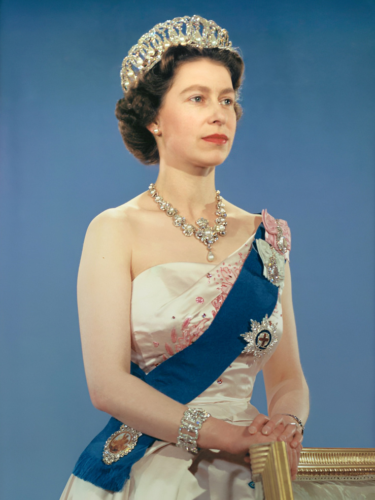
Portrait of Elizabeth II (1926–2022)
Portrait of Elizabeth II (1926–2022) Donald McKague · Public domain · Commons

Papua New Guinea (PNG), officially the Independent State of Papua New Guinea, is an island nation in Oceania that comprises the eastern half of the island of New Guinea and offshore islands in Melanesia, a region of the southwestern Pacific Ocean north of Australia. It has a land border with Indonesia to the west and maritime borders with Australia to the south and the Solomon Islands to the east. Its capital is Port Moresby. The country's 462,840 km2 (178,700 mi2) includes a large mainland and hundreds of islands.

From Wikipedia: Papua New Guinea (CC BY-SA 4.0)

Rulers

Government, Society and Religion

Papua New Guinea is a Commonwealth realm with Charles III as king. The monarch's representative is the governor-general of Papua New Guinea, who is elected by the unicameral National Parliament of Papua New Guinea. The National Parliament elects the prime minister of Papua New Guinea, who is then appointed by the governor-general. The other ministers are appointed by the governor-general on the prime minister's advice and form the National Executive Council of Papua New Guinea, which acts as the country's cabinet. The National Parliament sits for a maximum of five years. It has 118 seats, with 96 representing districts, and 22 representing province-level electorates (20 provinces, the National Capital District, and the Autonomous Region of Bougainville) who serve as governors of those provinces.

From Wikipedia: Papua New Guinea · Government and politics (CC BY-SA 4.0)

Government
Unitary parliamentary constitutional monarchy
Languages
English, Hiri Motu, PNG Sign Language, Tok Pisin

Economy and Trade

Papua New Guinea is classified as a developing economy by the International Monetary Fund. The economy is largely dependent on natural resources, with capital investment concentrated in mining and oil, while most labour is employed in agriculture. As of 2018, natural resource extraction made up 28% of overall GDP, with substantial contributors including minerals, oil, and natural gas. Measuring economic growth is difficult due to the resource-dependent economy distorting GDP. Other metrics such as gross national income are hard to measure. Even historical GDP estimates have changed dramatically. As of 2019, PNG's real GDP growth rate was 3.8%, with an inflation rate of 4.3%. The national currency, the Kina, is regulated by the Bank of Papua New Guinea, which has varied its approach to managing the exchange rate. Formal employment is low.

From Wikipedia: Papua New Guinea · Economy (CC BY-SA 4.0)

Coins, Currency and Symbols

Banknoten (Kina) und Münzen von Papua Neuguinea. 2- , 10- und 20-Kina-Banknote und 1-Kina-Münze. 1 Kina = 100 Toea
Banknoten (Kina) und Münzen von Papua Neuguinea. 2- , 10- und 20-Kina-Banknote und 1-Kina-Münze. 1 Kina = 100 Toea Bin im Garten · CC BY-SA 3.0 · Commons
Currency
kina
  • Flag of Papua New Guinea
    Flag of Papua New Guinea User:Nightstallion · Public domain · Commons
  • National emblem of Papua New Guinea
    National emblem of Papua New Guinea Sodacan · CC BY-SA 4.0 · Commons

Wars and Battles

During World War II, Japanese forces sought to capture Port Moresby, invading overland in mid-1942 and moving south in the Kokoda Track campaign. Australian forces carried out rearguard actions as they withdrew almost to Port Moresby. In September an Australian counter-offensive began, and Japanese forces fought rearguard actions as they retreated north. Australian forces were supported during this campaign through significant contributions from local soldiers and helpers. While this campaign was ongoing, the Japanese launched the Battle of Milne Bay, where their attack was repulsed by Australian and American forces. These events, along with the nearby Guadalcanal campaign, marked a turning point in the Pacific War. A war of attrition continued until 1944, when allied forces fully recaptured Papua and New Guinea.

From Wikipedia: Papua New Guinea · History: World War II and Australian rule (CC BY-SA 4.0)

Achievements and Monuments

Melanesian culture developed without significant external influence due to the isolation of New Guinea. This culture places significant importance on relationships, both between people and between a person and aspects of the natural environment. The importance of relationships is seen in the Kula ring trade, where items are traded to maintain relationships rather than for direct economic benefit. Connections to and ownership of land are important, although these are generally at the community level rather than an individual one. Local in-group relations are a strong component of the wantok system, and so treatment by individuals of those in their communities will often differ from the way they treat those of other communities. The value of actions is often evaluated predominantly or exclusively by impact on one's local community.

From Wikipedia: Papua New Guinea · Culture (CC BY-SA 4.0)

Decline and Fall

Ended
2024 CE
Last recorded ruler
Charles III

Legacy in the Modern World

It is likely that some ships from China and Southeast Asia visited the island at times and that there was some contact with New Guinean communities. Portuguese explorer António de Abreu was the first European to discover the island of New Guinea. Portuguese traders introduced the South American sweet potato to the Moluccas. From there, it likely spread to New Guinea sometime in the 17th or 18th century, initially from the southern coast. It spread inland to the highlands and became a staple food. The introduction of the sweet potato, possibly alongside other agricultural changes, transformed traditional agriculture and societies. This likely led to the spread of the big man social structure. Sweet potato largely supplanted the previous staple, taro, and led to significant population growth in the highlands.

Read more

By the 19th century, there was some trade with the Dutch East Indies.

From Wikipedia: Papua New Guinea · History: European influence (CC BY-SA 4.0)

Federation of Malaya

1958 CE – 1962 CE · Capital: Kuala Lumpur · 139,312 km²

HRH Tuanku Abdul Rahman Ibni Al-Marhum Tuanku Muhammad (1895 - 1960). Unknown photographer and date. The original image is on display at the Tuanku Ja'afar Royal Gallery, Seremban, Negeri Sembilan, Malaysia.
HRH Tuanku Abdul Rahman Ibni Al-Marhum Tuanku Muhammad (1895 - 1960). Unknown photographer and date. The original image is on display at the Tuanku Ja'afar Royal Gallery, Seremban, Negeri Sembilan, Malaysia. anonymity · Public domain · Commons

Malaya, officially the Federation of Malaya, was a country in Southeast Asia from 1948 to 1963. It succeeded the Malayan Union and, before that, British Malaya. It comprised eleven states – nine Malay states and two of the Straits Settlements, Penang and Malacca. It was established on the 1st of February 1948. Initially a self-governing colony of the United Kingdom, Malaya became fully sovereign on 31 August 1957, and on 16 September 1963, the federation was superseded by Malaysia when it united with Singapore, North Borneo (Sabah) and Sarawak.

From Wikipedia: Federation of Malaya (CC BY-SA 4.0)

Origins and Founding

Founded
1958 CE
Preceded by
Malayan Union

Rulers

Government, Society and Religion

Prior to its independence, the government of the Federation of Malaya was headed by a British high commissioner with executive powers, assisted and advised by the Federation of Malaya Executive Council and the Federation of Malaya Legislative Council.

Read more

The Federation of Malaya Executive Council comprised 7 official and 7 unofficial members.

The Federation of Malaya Legislative Council comprised the high commissioner as the council president, 14 official and 50 unofficial members representing the Straits Settlements, business groups and all races. Additionally, 9 State Council Yang Di Pertua (heads of state), chief ministers and 2 representatives from the Straits Settlements became unofficial members.

The Malay Conference of Rulers would advise the high commissioner on immigration issues. The British Resident was replaced with a chief minister in each state of the federation.

From Wikipedia: Federation of Malaya · System of government (CC BY-SA 4.0)

Government
Federation as British protectorate (1948–1957), Federal parliamentary elective constitutional monarchy (1957–1963)
Languages
Malay

Coins, Currency and Symbols

Currency
Malaya and British Borneo dollar
  • Flag of Malaya (1950–1963)
    Flag of Malaya (1950–1963) No machine-readable author provided. Nightstallion assumed (based on copyright claims). · CC BY-SA 2.5 · Commons
  • Coat of arms of the Federation of Malaya
    Coat of arms of the Federation of Malaya This vector image includes elements that have been taken or adapted from this file: · Public domain · Commons

Decline and Fall

Ended
1962 CE
Last recorded ruler
Hisamuddin Alam Shah of Selangor
Succeeded by
Malaysia

East Timor

2006 CE – 2024 CE · Capital: Dili · 18,567 km²

Photo by J. Patrick Fischer Town of Lospalos/Timor-Leste on 24th June 2002
Photo by J. Patrick Fischer Town of Lospalos/Timor-Leste on 24th June 2002 J. Patrick Fischer · CC BY 2.5 · Commons

Timor-Leste, also known as East Timor, officially the Democratic Republic of Timor-Leste, is a country in Southeast Asia. It comprises the eastern half of the island of Timor, the coastal exclave of Oecusse in the island's northwest, and the islands of Atauro and Jaco, for a total land area of 15,007 square kilometres (5,794 sq mi). Timor-Leste shares a land border with Indonesia to the west; Australia is the country's southern neighbour, across the Timor Sea. Dili, on the north coast of Timor, is its capital and largest city.

From Wikipedia: Timor-Leste (CC BY-SA 4.0)

Origins and Founding

Cultural remains at Jerimalai on the eastern tip of Timor-Leste have been dated to 42,000 years ago. The first known inhabitants are those who arrived during the Australo-Melanesian migration through the region, likely bringing the precursors to today's Papuan languages. A later migration of Austroasiatic-speakers is suspected, although no such languages remain. The arrival of Austronesian peoples brought new languages, and merged with existing cultures on the island. Timorese origin myths recount settlers sailing around the eastern end of the island before landing in the south. These people are sometimes noted as being from the Malay Peninsula or the Minangkabau highlands of Sumatra. Austronesian migration to Timor may be associated with the development of agriculture on the island.

From Wikipedia: Timor-Leste · History: Prehistory and Classical era (CC BY-SA 4.0)

Founded
2006 CE
Preceded by
Timor Timur
Preceded by
Portuguese Timor

Rulers

Government, Society and Religion

The political system of Timor-Leste is semi-presidential, based upon the Portuguese system. The constitution establishes both this separation of executive powers between the president and the prime minister; and the separation of powers between the executive, legislature, and judiciary. Individuals are not allowed to participate in both the legislature and the executive branch. The legislature is intended to provide a check on the executive; in practice the executive has maintained control of the legislature under all political parties, reflecting the dominance of individual leaders within political parties and coalitions. The executive, through the council of ministers, also holds some formal legislative powers. The judiciary operates independently, although there are instances of executive interference.

From Wikipedia: Timor-Leste · Government and politics (CC BY-SA 4.0)

Government
Unitary semi-presidential republic
Languages
Portuguese, Tetun
Religion
Catholicism, Protestantism, Islam

Economy and Trade

The economy of Timor-Leste is a market economy, although it is dependent upon the export of a few commodities and has a large public sector. Internally, market operations are limited by widespread poverty. The country uses the United States dollar, producing its own coins to facilitate smaller transactions. The economy is generally open to foreign investment, although a prohibition on foreigners owning land means many require a local partner in the country. Competition is limited by the small size of the economy, rather than any government barriers. There are far more imports than exports, and prices for goods are often higher than in nearby countries. Inflation is strongly affected by government spending. Growth has been slow, averaging just 2.5% per year from 2011 to 2021.

Read more

Most of the country is very poor, with just more than 40% living under the national poverty line.

From Wikipedia: Timor-Leste · Economy (CC BY-SA 4.0)

Coins, Currency and Symbols

50 and 200 Centavos. Centavos are coins used in East Timor and used for equivalent value of smaller denominations of US dollar bills. 200 Centavos would be equivalent of 2 USD.
50 and 200 Centavos. Centavos are coins used in East Timor and used for equivalent value of smaller denominations of US dollar bills. 200 Centavos would be equivalent of 2 USD. Khairil Yusof · CC BY 4.0 · Commons
Currency
United States dollar, East Timor centavo coins
  • Flag of East Timor
    Flag of East Timor See File history, below, for details. · Public domain · Commons
  • Coat of arms of East Timor
    Coat of arms of East Timor en:User:Vino4u · Public domain · Commons

Wars and Battles

Achievements and Monuments

The culture of Timor-Leste stem from several waves of Austronesian and Melanesian migration that led to the current population, with unique identities and traditions developing within each petty kingdom. Portuguese authorities built upon traditional structures, blending Portuguese influence into the existing political and social systems. The presence of the Catholic Church created a point of commonality across the various ethnic groups, despite full conversion remaining limited. The Portuguese language also provided common linkages, even if direct Portuguese impact was limited. Under Indonesian rule, resistance strengthened cultural links to Catholicism and the Portuguese language. At the same time, Indonesian cultural influence was spread through schools and administration.

From Wikipedia: Timor-Leste · Culture (CC BY-SA 4.0)

Decline and Fall

Ended
2024 CE
Last recorded ruler
José Ramos-Horta

Modern States of Maritime Southeast Asia: Frequently Asked Questions

Which states existed in Maritime Southeast Asia in this period?

This page maps 9 states of Maritime Southeast Asia founded between 1800 CE and 2006 CE: Dutch East Indies, Riau-Lingga Sultanate, Kedah-Perlis District, Kingdom of Sarawak, Pahang Sultanate, First Spanish Republic, Papua New Guinea, Federation of Malaya, East Timor.

Which was the largest of the Modern States of Maritime Southeast Asia?

Dutch East Indies had the largest mapped extent, about 2,023,054 km².

Which of the Modern States of Maritime Southeast Asia lasted longest?

Dutch East Indies lasted longest, 1800 CE – 1949 CE.

Sources

  • Reading text: Wikipedia articles on the group and each state, condensed (CC BY-SA 4.0).
  • Facts, rulers and wars: Wikidata (CC0).
  • Borders: Cliopatria, Seshat Global History Databank (CC BY 4.0).
  • Pictures: Wikimedia Commons; the author and licence are under each picture.

Largest state by mapped extent: Dutch East Indies.