
UNESCO World Heritage Sites in Chad
Chad has 2 sites on the UNESCO World Heritage List (1 natural and 1 mixed), the first inscribed in 2012 (Lakes of Ounianga). The map below plots every one of them alongside the rest of the List, and each site is written up in full further down the page.
- World Heritage Sites
- 2
- Cultural
- 0
- Natural and Mixed
- 2
- First Inscribed
- 2012
Map of World Heritage Sites in Chad
CulturalNaturalMixedIn DangerLarge dots are in Chad. Click a dot to read about the site.

Lakes of Ounianga
Chad · 18.9833° N, 20.6667° E · 628 km²
The Lakes of Ounianga (French: Lacs d'Ounianga, Arabic: بحيرات أونيانجا, romanized: Buḥayrāt ʾUniyāngā) is a series of lakes in the Sahara Desert, occupying a basin in the mountains of West Tibesti and Ennedi East in north-eastern Chad. It was added as a UNESCO World Heritage site in 2012.
According to the UNESCO description, the lakes are in a hot and hyperarid desert that features a rainfall of less than 2 millimetres (0.1 in) a year. The lakes exhibit a variety of sizes, depths, chemical compositions and colorations.
There is a total of 18 lakes in groups as follows:
Ounianga Kébir group: Lake Yoa, Lake Katam, Lake Oma (or Ouma), Lake Béver, Lake Midji, Lake Forodom;
Lake Motro, about 30 kilometres (19 mi) southeast of Ounianga Kébir;
Ounianga Sérir group about 45 to 60 kilometres (28 to 37 mi) southeast of Ounianga Kébir: Lake Melekui, Lake Dirke, Lake Ardjou, Lake Téli, Lake Obrom, Lake Élimé, Lake Hogo, Lake Djiara, Lake Ahoita, Lake Daléyala, and Lake Boukkou.
The total surface area of the lakes is about 20 square kilometres (8 mi2). The largest of the lakes, Lake Yoa, has about a 3.5-square-kilometre (1 mi2) area and attains 20 metres (66 ft) in depth.
Adapted from Wikipedia: Lakes of Ounianga (CC BY-SA 4.0).
Why Lakes of Ounianga Is Listed
- (vii)
- Superlative natural phenomena or exceptional natural beauty.
More about Lakes of Ounianga
UNESCO's Description
The site includes eighteen interconnected lakes in the hyper arid Ennedi region of the Sahara desert covering an area of 62,808 ha. It constitutes an exceptional natural landscape of great beauty with striking colours and shapes. The saline, hyper saline and freshwater lakes are supplied by groundwater and are found in two groups 40 km apart. Ounianga Kebir comprises four lakes, the largest of which, Yoan, covers an area of 358 ha and is 27 m deep. Its highly saline waters only sustain algae and some microorganisms. The second group, Ounianga Serir, comprises fourteen lakes separated by sand dunes. Floating reeds cover almost half the surface of these lakes reducing evaporation. At 436 ha, Lake Teli has the largest surface area but is less than 10 m deep. With their high quality freshwater, some of these lakes are home to aquatic fauna, particularly fish.
From the UNESCO World Heritage Centre (CC BY-SA IGO 3.0).
Geography
Water accumulated in an underground aquifer during the wet millennia is supplied to the lakes.
When water is exposed at the surface in highly arid environments it becomes saline due to a high rate of evaporation as is the case with the lakes of the Ounianga Kebìr group. The rate of evaporation from Lake Yoa is equivalent to 6 metres (20 ft) a year and the total lake depth is 25 metres (82 ft).
The lakes of the Ounianga Sérir group form a hydrological system that is unique in Earth’s deserts.
Unique physical factors combine to keep all of the lakes fresh, except the central Lake Teli.
Wind blown sand separated the basin into 10 lakes with Lake Teli occupying the central position.
Connection to the history of humanity
The climatic history of the region is speculated to have a connection to human migrations at the end of the last ice age about 11,000 years ago. The desert returned to the area after monsoons diminished about 5,000 years ago. Investigation of a drilling core revealed 10,940 layers in 16 metres (52 ft) of sediments from the bottom of the Lake Yoa before reaching the ice-age desert floor, each layer corresponding to 1 year.
There is aerial photographic evidence that shows early human settlers of the lakes attempted to stop the desertification that inevitably buried their orchards and crops.
During the African humid period the early humans found the freshwater lake area to be fertile enough to grow crops and may have also domesticated cattle.
Sections adapted from Wikipedia: Lakes of Ounianga (CC BY-SA 4.0).
Ennedi Plateau
Chad · 17.2500° N, 22.0000° E · 24,412 km²
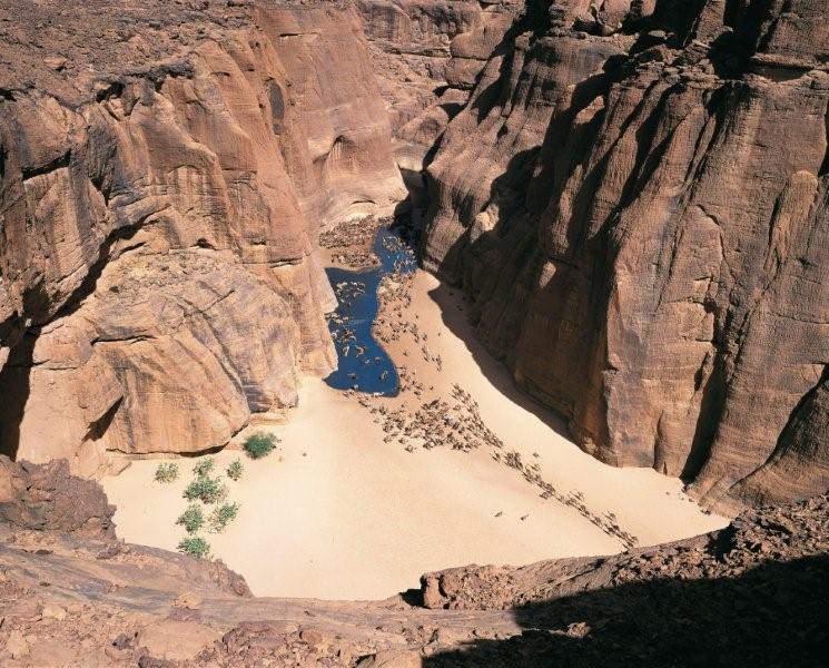
The Ennedi Plateau is located in the northeast of Chad, in the regions of Ennedi-Ouest and Ennedi-Est. It is considered a part of the group of mountains known as the Ennedi Massif found in Chad, which is one of the nine countries that make up the Sahelian belt that spans the Atlantic Ocean to Sudan. The Ennedi is a sandstone bulwark in the middle of the Sahara, which was formed by erosion from wind and temperature. Many people occupied this area, such as hunters-gatherers (5,000-4,000 cal BC) and pastoralists (beginning 4,000 cal BC). The Ennedi area is also known for its large collection of rock art depicting mainly cattle, as these animals had the greatest financial, environmental, and cultural impact. This art dates back nearly 7,000 years ago. Today, two semi-nomadic groups, mainly Muslim, live in the Ennedi during the rainy months and pass through the area during the dry season. They rely on their herds of camels, donkeys, sheep, and goats to survive.
Adapted from Wikipedia: Ennedi Plateau (CC BY-SA 4.0).
Why Ennedi Plateau Is Listed
- (iii)
- A unique testimony to a cultural tradition or civilisation.
- (vii)
- Superlative natural phenomena or exceptional natural beauty.
- (ix)
- An outstanding example of ongoing ecological and biological processes.
More about Ennedi Plateau
UNESCO's Description
In the northeast of the country, the sandstone Ennedi Massif has been sculpted over time by water and wind erosion into a plateau featuring canyons and valleys that present a spectacular landscape marked by cliffs, natural arches and pitons. In the largest canyons, the permanent presence of water plays an essential role in the Massif’s ecosystem, sustaining flora and fauna as well as human life. Thousands of images have been painted and carved into the rock surface of caves, canyons and shelters, presenting one of the largest ensembles of rock art in the Sahara.
From the UNESCO World Heritage Centre (CC BY-SA IGO 3.0).
Geology
The plateau consists of Cambrian-Ordivician to Carboniferous sandstone on the north-facing Gondwana platform. The sandstone overlies the Pan-African basement consisting of granites, gneiss, or quartzite ridges. Glacial lineations, plus ridge-and-trough topography, record the Andean-Saharan glaciation.
Landscape and climate
The Ennedi makes up an area of approximately 60,000 km2 (23,000 sq mi), as large as Switzerland, and its highest point is approximately 1,450 m (4,760 ft) above sea level. The Massif is composed of sandstone overlaying a Precambrian granite base. In the Ennedi, there are at least twenty perennial or semi-perennial springs, gueltas (desert ponds), and pools, but they rarely reach greater than a few dozen meters in the dry season. It is considered part of the Sahelian Acacia savanna, which extends across the entire continent which once contained diverse ungulates whose population has since been reduced. The landscape has geological structures, including towers, pillars, bridges, and arches, which serve as major tourist attractions.
History of protection
Just under one-tenth of World Heritage Sites are in Africa, but the site was added to the UNESCO World Heritage Site in February 2016. During this process, there was much debate over what should be included. First of all, two administration zones and several villages had to reach agreement on whether it was considered a part of the World Heritage Site. However, its establishment has benefited Chad by increasing income in the area from tourists who spend money to stay. Also, the Chadian government eventually reduced the size of the protected area due to oil exploration. The Ennedi suffers from high income inequality, so the use of oil reserves has allowed for better redistribution of wealth.
Sections adapted from Wikipedia: Ennedi Plateau (CC BY-SA 4.0).
Visiting Ennedi Plateau
The Ennedi Plateau is a sandstone plateau in Saharan Chad and a UNESCO World Heritage Site.
About 50,000 km2 (19,000 sq mi), a large portion of the Ennedi Plateau, was designated as the Ennedi Natural and Cultural Reserve by the Chadian government in January 2019.
Travel notes adapted from Wikivoyage: Ennedi Plateau (CC BY-SA 4.0).
World Heritage in Chad: Quick Answers
- How many UNESCO World Heritage Sites are in Chad?
- Chad has 2 World Heritage Sites: 1 natural and 1 mixed.
- What was the first World Heritage Site in Chad?
- Lakes of Ounianga, inscribed in 2012. The most recent is Ennedi Plateau, inscribed in 2016.
- What are the natural World Heritage Sites in Chad?
- Lakes of Ounianga, Ennedi Plateau (mixed).
- Are any World Heritage Sites in Chad in danger?
- None of the World Heritage Sites in Chad is on UNESCO's List of World Heritage in Danger.