
Map of Djibouti
Djibouti is a country in Africa with its capital at Djibouti, home to about 1.18 million people across 23,200 km². The interactive map below plots 5 cities and towns, 2 lakes, 1 mountain summits and 1 ports recorded for Djibouti in YearMaps.
- Population
- 1.18 million
- Area
- 23,200 km²
- Capital
- Djibouti
- Continent
- Africa
Interactive Map of Djibouti
Centred on Djibouti at 11.5950° N, 43.1480° E. Use the layer panel to switch on rivers, dams, ports, peaks and historical borders.
About Djibouti
Djibouti, officially the Republic of Djibouti, is a country in the Horn of Africa, bordered by Somalia to the south, Ethiopia to the southwest, Eritrea in the north, and the Red Sea and the Gulf of Aden to the east. The country has an area of 23,200 km2 (8,958 sq mi).
In antiquity, the territory, together with Ethiopia, Eritrea and Somaliland, was part of the Land of Punt. Nearby Zeila, now in Somaliland, was the seat of the medieval Adal and Ifat Sultanates. In the late 19th century, the colony of French Somaliland was established after the ruling Dir-Somali, and Afar sultans signed treaties with the French, and its railroad to Dire Dawa (and later Addis Ababa) allowed it to quickly supersede Zeila as the port for southern Ethiopia and the Ogaden. It was renamed the French Territory of the Afars and the Issas in 1967. A decade later, the Djiboutian people voted for independence. This officially marked the establishment of the Republic of Djibouti, named after its capital city. The new state joined the United Nations in its first year. In the early 1990s, tensions over government representation led to armed conflict, which ended in a power-sharing agreement in 2000 between the ruling party and the opposition.
Djibouti is a multi-ethnic nation with a population of 1,066,809 at the census held on 20 May 2024 (the smallest in mainland Africa). French and Arabic are its two official languages; Afar and Somali are national languages. About 94% of Djiboutians adhere to Islam, which is the official religion and has been predominant in the region for more than 1,000 years. The Somalis and Afar make up the two largest ethnic groups, with the former comprising the majority of the population. Both speak a language of the Cushitic branch of the Afroasiatic languages.
Djibouti is near some of the world's busiest shipping lanes, controlling access to the Red Sea and Indian Ocean. It serves as a key refuelling and transshipment center and the principal maritime port for imports from and exports to neighboring Ethiopia. The nation is the site of various foreign military bases. The Intergovernmental Authority on Development (IGAD) regional body also has its headquarters in Djibouti City.
Summary adapted from Wikipedia: Djibouti (CC BY-SA 4.0).

Geography and Climate of Djibouti
Present-day Djibouti was the site of the medieval Ifat and Adal Sultanates. In the late 19th century, the Afar sultans signed treaties with the French that allowed the latter to establish the colony of French Somaliland in 1862. The French signed additional treaties with the ethnic Somali in 1885. Tension between the ethnic Afar and Somali populations increased over time, as the ethnic Somalis perceived that the French unfairly favored the Afar and gave them disproportionate influence in local governance. In 1958, the French held a referendum that provided residents of French Somaliland the option to either continue their association with France or to join neighboring Somalia as it established its independence. Ethnic Somali protested the vote, because French colonial leaders did not recognize many Somali as residents, which gave the Afar outsized influence in the decision to uphold ties with France. After a second referendum in 1967, the French changed the territory’s name to the French Territory of the Afars and the Issas, in part to underscore their relationship with the ethnic Afar and downplay the significance of the ethnic Somalis. A final referendum in 1977 established Djibouti as an independent nation and granted ethnic Somalis Djiboutian nationality, formally resetting the balance of power between the majority ethnic Somalis and minority ethnic Afar residents. Upon independence, the country was named after its capital city of Djibouti. Hassan Gouled APTIDON, an ethnic Somali leader, installed an authoritarian one-party state and served as president until 1999. Unrest between the Afar minority and Somali majority culminated in a civil war during the 1990s that ended in 2001 with a peace accord between Afar rebels and the Somali Issa-dominated government. In 1999, Djibouti's first multiparty presidential election resulted in the election of Ismail Omar GUELLEH as president; he was reelected to a second term in 2005 and extended his tenure in office via a constitutional amendment, which allowed him to serve his third and fourth terms, and to begin a fifth term in 2021. Djibouti occupies a strategic geographic location at the intersection of the Red Sea and the Gulf of Aden. Its ports handle 95% of Ethiopia’s trade. Djibouti’s ports also service transshipments between Europe, the Middle East, and Asia. The government has longstanding ties to France, which maintains a military presence in the country, as do the US, Japan, Italy, Germany, Spain, and China.
- Location
- Eastern Africa, bordering the Gulf of Aden and the Red Sea, between Eritrea and Somalia.
- Climate
- Desert; torrid, dry.
- Terrain
- Coastal plain and plateau separated by central mountains.
- Highest point
- Moussa Ali 2,021 m.
- Lowest point
- Lac Assal -155 m.
- Coastline
- 314 km.
- Land borders
- Total: 528 km; border countries: Eritrea 125 km; Ethiopia 342 km; Somalia 61 km.
- Major lakes
- Salt water lake(s): Abhe Bad/Abhe Bid Hayk (shared with Ethiopia) - 780 sq km.
- Natural resources
- Potential geothermal power, gold, clay, granite, limestone, marble, salt, diatomite, gypsum, pumice, petroleum.
- Land use
- Agricultural land: 73.5% (2023 est.); arable land: 0.1% (2023 est.); permanent crops: 0% (2023 est.); permanent pasture: 73.3% (2023 est.); forest: 0.3% (2023 est.); other: 26.2% (2023 est.)
- Natural hazards
- Earthquakes; droughts; occasional cyclonic disturbances from the Indian Ocean bring heavy rains and flash floods volcanism: experiences limited volcanic activity; Ardoukoba (298 m) last erupted in 1978; Manda-Inakir, located along the Ethiopian border, is also historically active.
- Geographic note
- Strategic location near world's busiest shipping lanes and close to Arabian oilfields; Lac Assal (Lake Assal) is the lowest point in Africa and the saltiest lake in the world.
- Languages
- French (official), Arabic (official), Somali, Afar.
- Religions
- Sunni Muslim 94% (nearly all Djiboutians), other 6% (mainly foreign-born residents - Shia Muslim, Christian, Hindu, Jewish, Baha'i, and atheist)
- Ethnic groups
- Somali 60%, Afar 35%, other 5% (mostly Yemeni Arab, also French, Ethiopian, and Italian)
- Economy
- Food import-dependent Horn of Africa economy driven by various national military bases and port-based trade; fairly resilient from COVID-19 disruptions; major re-exporter; increasing Ethiopian and Chinese trade relations; investing in infrastructure.
From the CIA World Factbook (public domain), archived edition of 2026-01-22. The Factbook is no longer updated, so figures reflect that edition.
Djibouti in Numbers
- Population
- 1.18 million
- GDP
- US$4.6 billion
- GDP per person
- US$3,906
- Life expectancy
- 66.2 years
- Population growth
- 1.30% a year
- Population density
- 50 per km²
- Urban population
- 73.0%
- Surface area
- 23,200 km²
- Forest cover
- 0.3%
- Arable land
- 0.2%
- Access to electricity
- 69.2%
- Internet users
- 65.3%
Indicators from World Bank Open Data (CC BY 4.0). The year under each figure is its reference year.
Djibouti in Depth
History
The Bab-el-Mandeb region has often been considered a primary crossing point for early hominins following a southern coastal route from East Africa to South and Southeast Asia.
The Djibouti area has been inhabited since the Neolithic. According to linguists, the first Afroasiatic-speaking populations arrived in the region during this period from the family's proposed urheimat ("original homeland") in the Nile Valley, or the Near East. Other scholars propose that the Afroasiatic family developed in situ in the Horn, with its speakers subsequently dispersing from there.
Cut stones dated about 3 million years old have been collected in the area of Lake Abbe.
Geography
Djibouti is in the Horn of Africa, on the Gulf of Aden and the Bab-el-Mandeb, at the southern entrance to the Red Sea. It lies between latitudes 11° and 14°N and longitudes 41° and 44°E, at the northernmost point of the Great Rift Valley. It is in Djibouti that the rift between the African Plate and the Somali Plate meets the Arabian Plate, forming a geologic tripoint. The tectonic interaction at this tripoint has created the lowest elevation of any place in Africa at Lake Assal, and the second-lowest depression on dry land anywhere on earth (surpassed only by the depression along the border of Jordan and Israel).
The country's coastline stretches 314 kilometres (195 miles), with terrain consisting mainly of plateau, plains and highlands.
Economy
Djibouti's economy is largely concentrated in the service sector. Commercial activities revolve around the country's free trade policies and strategic location as a Red Sea transit point. Due to limited rainfall, vegetables and fruits are the principal production crops, and other food items require importation. The GDP (purchasing power parity) in 2013 was estimated at $2.505 billion, with a real growth rate of 5% annually. Per capita income is around $2,874 (PPP). The services sector constituted around 79.7% of the GDP, followed by industry at 17.3%, and agriculture at 3%.
As of 2013, the container terminal at the Port of Djibouti handles the bulk of the nation's trade.
Demographics
Djibouti had a population of 1,066,809 inhabitants at the Census held on 20 May 2024. It is a multiethnic country. The local population grew rapidly during the latter half of the 20th century, increasing from about 69,589 in 1955 to around 869,099 by 2015. The two largest ethnic groups native to Djibouti are the Somalis (60%) and the Afar (35%). The Somali clan component is mainly composed of the Issa (who make up 33%), followed by the Gadabuursi (15–20%) and the Isaaq (13.3-20%). The remaining 5% of Djibouti's population primarily consists of Yemeni Arabs, Ethiopians and Europeans (French and Italians). Approximately 76% of local residents are urban dwellers; the remainder are pastoralists.
Sections adapted from Wikipedia: Djibouti (CC BY-SA 4.0).
Djibouti: Key Facts
| Currency | Djiboutian franc |
|---|---|
| Official languages | French, Arabic |
| Head of state | Ismail Omar Guelleh |
| Head of government | Abdoulkader Kamil Mohamed |
| Calling code | +253 |
| Internet domain | .dj |
| Highest point | Mousa Ali |
| Lowest point | Lake Assal |
| Established | 23 June 1977 |
Facts from Wikidata Q977 (CC0).
History of Djibouti: Empires and States
The atlas records 9 polities whose mapped territory included part of Djibouti, from Ifat Sultanate in 1285 CE to 2024 CE. They are listed in the order they first appear.
| Polity | Period here | Extent |
|---|---|---|
| Ifat Sultanate | 1285–1414 CE | Nearly all |
| Adal Sultanate | 1415–1546 CE | Nearly all |
| Sultanate of Harar | 1547–1578 CE | Nearly all |
| French Third Republic | 1890–1939 CE | Nearly all |
| French Africa | 1890–1957 CE | Nearly all |
| The French Colonial Empire | 1890–1957 CE | Nearly all |
| French Fourth Republic | 1945–1957 CE | Nearly all |
| French Fifth Republic | 1958–2023 CE | Nearly all |
| Republic of Djibouti | 1979–2024 CE | Nearly all |
Historical Maps of Djibouti
Djibouti on the world map in each year one of these states held it:
Derived by testing mapped cities against dated territorial polygons. Dates are when the polygons cover this place, not the polity's whole lifespan, and polities absent from the source dataset are not listed.
Visiting Djibouti
Djibouti is in the Horn Peninsula on the Gulf of Aden. The country can be divided into three regions; the coastal plain and volcanic plateaus in the central and southern parts of the country and the mountain ranges in the north. Much of the country is wasteland with virtually no arable land.
Travel notes adapted from Wikivoyage: Djibouti (CC BY-SA 4.0).
Largest Cities in Djibouti
5 cities recorded. Ranked by metropolitan population. A port city's harbour is written up on the page of its sea.
| # | Name | Population | Region | Role |
|---|---|---|---|---|
| 1 | Djibouti | 923,000 | Djibouti | National capital |
| 2 | Ali Sabih | 40,074 | Ali Sabieh | Admin-1 capital |
| 3 | Tadjoura | 22,193 | Tadjourah | Admin-1 capital |
| 4 | Obock | 17,776 | Obock | Admin-1 capital |
| 5 | Dikhil | 12,043 | Dikhil | Admin-1 capital |
Highest Mountains in Djibouti
1 mountain recorded. Ranked by summit elevation above sea level. A summit on a border is listed under both countries.
| # | Name | Elevation | Feet | Region |
|---|---|---|---|---|
| 1 | Moussa Ali | 2,021 m | 6,631 ft | Africa |

Moussa Ali
Mountain · 2,021 m
Moussa Ali is a mountain rising to 2,021 metres (6,631 ft) in Djibouti, Ethiopia and Eritrea, in the Africa region. The summit stands on the borders between them. From PeakBagger.com, with kind permission..
Mousa Ali (Arabic: موسى علي, French: Mousa Alli, Italian: Moussa Ali) is a 2,021 metres (6,631 ft) stratovolcano located on the tri-point of Ethiopia, Eritrea and Djibouti. The volcano is the highest point in Djibouti. The volcano's summit is truncated by a caldera, which contains rhyolitic lava domes and lava flows. The last known eruption occurred before the Holocene epoch.
Mousa Ali is situated at the tri-point of the Tadjourah Region of Djibouti, the Southern Red Sea Region of Eritrea, and the Afar Region of Ethiopia.
Adapted from Wikipedia: Mousa Ali (CC BY-SA 4.0).
- Elevation
- 2,021 m (6,631 ft)
- Global rank
- #415 of 641 indexed
- Region
- Africa (#63)
- Countries
- Djibouti, Ethiopia, Eritrea
- Coordinates
- 12.4501°, 42.4100°
Of the 641 named summits indexed in YearMaps, Moussa Ali ranks #415 by elevation, below Mont Bagzane (2,022 m) and above Pummel Pk (2,018 m).
- Ranges:
- Ahmar Mountains (Africa), Ogo Mountains (Africa)
More about Moussa Ali
Geography
The mountain has two distinct summits, the higher being the south one with an elevation of 2,021 metres. The north summit in Ethiopia has an elevation of 1,871 metres. Both summits are separated by a large caldera, about 1 km (0.71 mi) wide and 1514 metres deep. Mousa Ali, in the northern part of the Great Rift Valley region, has Eritrea on its northern flank, Ethiopia on the west, and Djibouti the east and south. The Djiboutian town of Dorra is 36 km to the south-southeast, the Ethiopian volcano Manda-Inakir is 22 km to the southwest, and the road from the Ethiopian town of Manda to the Eritrean port of Assab is 19 km to the northwest.
History
Two sects of Afar live in the area. They are collectively known as Adrúmmi, from 'Adó rum li or "white as Byzantines."
The position of Ali Mousa as the tripoint between Ethiopia, Eritrea and Djibouti is not the result of an agreement between the three countries. In December 1948 the British administering Eritrea refused to attend a meeting with the other two parties to determine the exact location of their tripoint, set in a 1908 treaty as 60 km inland from the Red Sea. British administration of Eritrea ended in 1952, and with increasing Ethiopian administration over the ensuing decade, and incorporation into Ethiopia from 1962 to 1993, the boundary was internal, not international.
Sections adapted from Wikipedia: Mousa Ali (CC BY-SA 4.0).
Moussa Ali: Key Facts
| Topographic prominence | 1,607 m |
|---|
Facts from Wikidata Q1951029 (CC0).
Largest Lakes in Djibouti
2 lakes recorded. Ranked by mapped surface area. A lake on a border is listed under each country it lies in, with the area of the whole lake.
| # | Name | Surface Area | Type |
|---|---|---|---|
| 1 | Lake Abbe | 339 km² | Alkaline Lake |
| 2 | Lake Assal | 37 km² | Alkaline Lake |
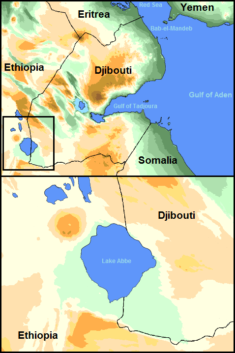
Lake Abbe
Alkaline Lake · 339 km²
Lake Abbe is a alkaline lake in Ethiopia and Djibouti, with a mapped surface area of about 339 km². About 43% of its surface lies in Djibouti, and the rest in Ethiopia.
Lake Abbe, also known as Lake Abhe Bad, is a salt lake, lying on the Ethiopia-Djibouti border. It is one of a chain of six connected lakes, which also includes (from north to south) lakes Gargori, Laitali, Gummare, Bario and Afambo. The lake is the ultimate destination of the Awash River, which is at the center of the Afar Triangle. Lake Abbe is considered one of the most inaccessible areas of the earth. The water itself is known for its flamingos.
Adapted from Wikipedia: Lake Abbe (CC BY-SA 4.0).
- Surface area
- 339 km²
- Area rank
- #382 of 756 indexed
- Type
- Alkaline Lake
- Countries
- Ethiopia, Djibouti
- Coordinates
- 11.1891°, 41.7717°
Among the 756 water bodies with a mapped extent in YearMaps, Lake Abbe ranks #382 by surface area, after Moosehead Lake (342 km²) and ahead of Kinbasket Lake (335 km²). Areas are computed from the mapped outline and are approximate.
More about Lake Abbe
Overview
Lake Abbe is the ultimate destination of the waters of the Awash River. It lies at the Afar triple junction, the central meeting place for the three pieces of the Earth's crust, a defining feature of the Afar Depression. Here three pieces of Earth's crust are each pulling away from that central point, though not all at the same speed.
On the northwest shore rises Mount Dama Ali (1068 m or 3,504 ft), a dormant volcano, while along the southwestern and southern shores extend vast salt flats, 10 km in width. Besides the Awash, seasonal affluents of Lake Abbe include two wadis, the Oleldere and Abuna Merekes, which enter the lake from the west and south, crossing the salt flats.
Climate
The Lake Abbe's climate offers year-round sunny skies and dry air. It has less than 172 millimetres (7 in) mean annual rainfall and a summer average temperature between 30 and 40 °C (86 and 104 °F). Temperatures in the coldest months range between 21 and 30 °C (70 and 86 °F) on average.
Sections adapted from Wikipedia: Lake Abbe (CC BY-SA 4.0).
Lake Abbe: Key Facts
| Surface area | 320 km² |
|---|---|
| Maximum depth | 37 m |
| Surface elevation | 243 m |
| Inflows | Awash River |
Facts from Wikidata Q306194 (CC0).
Ports in Djibouti
1 port recorded. Ranked by approach channel depth, the figure that limits which ships can call. Harbours link to their write-up on the page of the sea or coast they lie on.
| # | Name | Channel Depth | Class | Sea | Max Vessel |
|---|---|---|---|---|---|
| 1 | Doraleh | — | Small | Red Sea & Gulf of Aden | large vessels |
Mountain Ranges, Deserts and Landforms of Djibouti
1 landform recorded. Ranked by mapped area. Covers mountain ranges, deserts, plateaus, named glaciers, plains, basins, peninsulas and capes. One that crosses a border is listed under every country it lies in, with the area of the whole feature.
| # | Name | Area | Type | Region |
|---|---|---|---|---|
| 1 | Danakil | 3,542 km² | Desert | Africa |

Danakil
Desert · 3,542 km²
Danakil is a desert in Africa, covering an estimated 3,542 km². It extends across Eritrea, Djibouti and Ethiopia.
The Danakil Desert (or Afar Desert) is a desert in northeast Ethiopia, southern Eritrea, and northwestern Djibouti. Situated in the Afar Triangle, it stretches across 136,956 square kilometres (52,879 mi2) of arid terrain. It is inhabited by a few Afar, who engage in salt mining. The area is known for its volcanoes and extreme heat, with daytime temperatures surpassing 50 °C (122 °F). Less than 25 mm (1 in) of rainfall occurs each year. The Danakil Desert is one of the lowest and hottest places on Earth.
Adapted from Wikipedia: Danakil Desert (CC BY-SA 4.0).
- Feature class
- Desert
- Mapped extent
- 3,542 km²
- Size rank
- #48 of 58 deserts
- Region
- Africa
- Countries
- Eritrea, Djibouti, Ethiopia
- Coordinates
- 11.7116°, 43.0740°
- Summits:
- Moussa Ali (2,021 m)
- Ranges:
- Ahmar Mountains (Africa), Ogo Mountains (Africa)
More about Danakil
Geology
Local geology is characterized by volcanic and tectonic activity, various climate cycles, and discontinuous erosion. The basic geological structure of this area was caused by the movement of tectonic plates as Africa moved away from Asia. Mountain chains formed and were eroded again during the Paleozoic. Inundations by the sea caused the formation of layers of sandstone, and limestone was deposited further offshore. As the land rose again, further sandstone formed above the limestone. Further tectonic shifts caused lava to pour out of cracks and cover the sedimentary deposits.
The Danakil Desert has a number of lakes formed by lava flows that dammed up several valleys. Among these is Lake Afrera, which has thick saline crusts on its banks.
Climate
Dallol (92 metres below sea level), has the highest average temperature recorded on earth. Dallol features an extreme version of a hot desert climate (Köppen climate classification BWh) typical of the Danakil Desert. Dallol is the hottest place year-round on the planet and currently holds the record high average temperature for an inhabited location on Earth, where an average annual temperature of 34.6 °C (94.3 °F) was recorded between the years 1960 and 1966. The annual average high temperature is 41.2 °C (105.4 °F) and the hottest month has an average high of 46.7 °C (116.1 °F). The highest temperature ever recorded is 49 °C (121 °F).
Sections adapted from Wikipedia: Danakil Desert (CC BY-SA 4.0).
Countries Bordering Djibouti
Land and maritime neighbours.
More Maps in Africa
Djibouti: Quick Answers
- What is the capital of Djibouti?
- The capital of Djibouti is Djibouti.
- What is the population of Djibouti?
- Djibouti has a population of about 1.18 million, the #160 largest of 225 countries in YearMaps. Source: World Bank, 2025.
- How big is Djibouti?
- Djibouti covers 23,200 km², ranking #152 by area, with about 51 people per square kilometre.
- Which continent is Djibouti in?
- Djibouti is in Africa.
- Which countries border Djibouti?
- Djibouti shares a land or maritime border with Ethiopia, Eritrea, Somalia.
- What is the largest city in Djibouti?
- Djibouti is the largest city in Djibouti, with a metropolitan population of about 923,000.
- What is the highest mountain in Djibouti?
- The highest summit recorded for Djibouti in YearMaps is Moussa Ali at 2,021 m (6,631 ft). Summits on a border are counted for both countries.
- What is the largest lake in Djibouti?
- The largest lake recorded in or bordering Djibouti is Lake Abbe, at roughly 339 km².