Ancient States of Anatolia and Cyprus: Map & History
15 states of Anatolia and Cyprus on one map, from 1600 BCE to 259 CE.The largest, Kingdom of Pontus, covered about 584,683 km²; the longest-lived, Hittites, lasted 1600 BCE – 1151 BCE. Each has its own section below with its rulers, capitals, wars and pictures where the records hold them.
Each state in its own colour. Move the timeline to see which existed in any year from 1600 BC to 259 AD; select a territory to read about it. Borders: Cliopatria / Seshat (CC BY 4.0).
The Ancient States of Anatolia and Cyprus Compared
1600 BCE – 1151 BCE · Capital: Hattusa, Šamuḫa (In exile under Tudḫaliya III), Tarḫuntašša (Regnal period of Muwatalli II) · 321,568 km²
Hittite stone lion at Ankara's Museum of Anatolian CivlizationsKoppas · CC BY-SA 3.0 · Commons
The Hittites were an Anatolian Indo-European people who formed one of the first major civilizations of the Bronze Age in West Asia. Possibly originating from beyond the Black Sea, they settled in north-central Anatolia in the early 2nd millennium BC. There they formed a series of polities, including the kingdom of Kussara (before 1750 BC), the Kanesh or Neša (c. 1750–1650 BC), and an empire centered on their capital, Hattusa (around 1650 BC).
The ancestors of the Hittites came into Anatolia between 4400 and 4100 BC, when the Anatolian language family split from Proto-Indo-European. Recent genetic and archaeological research has indicated that Proto-Anatolian speakers arrived in this region sometime between 5000 and 3000 BC. The Proto-Hittite language developed around 2100 BC, and the Hittite language itself is believed to have been in use in Central Anatolia between the 20th and 12th centuries BC.
Read more
The Hittites are first associated with the kingdom of Kussara sometime prior to 1750 BC.
Hittites in Anatolia during the Bronze Age coexisted with Hattians and Hurrians, either by means of conquest or by gradual assimilation. In archaeological terms, relationships of the Hittites to the Ezero culture of the Balkans and Maykop culture of the Caucasus had previously been considered within the migration framework.
Under both the old and reformed Hittite law codes, three main types of punishment can be seen: Death, torture, or compensation/fines. The articles outlined on the cuneiform tablets provide very specific punishments for crimes committed against the Hittite religion or against individuals. In many, but not all cases, articles describing similar laws are grouped together. More than a dozen consecutive articles describe what are known to be permitted and prohibited sexual pairings. These pairings mostly describe men (sometimes specifically referred to as free men, sometimes just men in general) having relations, be they consensual or not, with animals, step-family, relatives of spouses, or concubines. Many of these articles do not provide specific punishments but, prior to the law reforms, crimes against religion were most often punishable by death.
The Hittite economy was an Agro-Pastoral one. Barley (Hittite ḫalki) and various wheat cultivars (Hittite ZÍZ-tar) were the main types of grain cultivated. Grain silos where usually placed in administrative centers such as Hattusa. Livestock included cattle, sheep, goats, horses, mules, and donkeys, and, to a lesser extent, pigs.
Read more
In theory the land was owned by the gods, while in practice the King controlled the best lands, with a variety of other ownership forms after this. Land could be granted by the King to individuals in exchange for military service. The workforce working in food production was critical to the economy, thus wars taking men away from this could impact the food output of the Great Kingdom. Temples were an important part of the economy.
Shekels, minas and talents were the standard form of 'currency'. They were weights in either, copper, bronze, silver or gold.
Barter economy, gold, copper, silver and bronze common barter items of value.
Wars and Battles
Hittite prosperity was mostly dependent on control of the trade routes and metal sources. Because of the importance of Northern Syria to the vital routes linking the Cilician gates with Mesopotamia, defense of this area was crucial, and was soon put to the test by Egyptian expansion under Pharaoh Ramesses II. The outcome of the Battle of Kadesh is uncertain, though it seems that the timely arrival of Egyptian reinforcements prevented total Hittite victory. The Egyptians forced the Hittites to take refuge in the fortress of Kadesh, but their own losses prevented them from sustaining a siege. This battle took place in the 5th year of Ramesses (c. 1274 BC by the most commonly used chronology).
There are relatively few remains of Hittite art. Those that remain include some impressive monumental carvings, a number of rock reliefs, as well as metalwork, in particular the Alaca Höyük bronze standards, carved ivory, and ceramics, including the Hüseyindede vases. The Sphinx Gates of Alaca Höyük and Hattusa, with the monument at the spring of Eflatun Pınar, are among the largest constructed sculptures, along with a number of large recumbent lions, of which the Lion of Babylon statue at Babylon is the largest, if it is indeed Hittite. Nearly all are notably worn. Rock reliefs include the Hanyeri relief, and Hemite relief. The Niğde Stele from the end of the 8th century BC is a Luwian monument, from the Post-Hittite period, found in the modern Turkish city of Niğde.
After this date, the power of both the Hittites and Egyptians began to decline yet again because of the power of the Assyrians. The Assyrian king Shalmaneser I had seized the opportunity to vanquish Hurria and Mitanni, occupy their lands, and expand up to the head of the Euphrates, while Muwatalli was preoccupied with the Egyptians. The Hittites had vainly tried to preserve the Mitanni Kingdom with military support. Assyria now posed just as great a threat to Hittite trade routes as Egypt ever had. Muwatalli's son, Urhi-Teshub, took the throne and ruled as king for seven years as Mursili III before being ousted by his uncle, Hattusili III after a brief civil war. In response to increasing Assyrian annexation of Hittite territory, he concluded a peace and alliance with Ramesses II (also fearful of Assyria), presenting his daughter's hand in marriage to the Pharaoh.
Archäologisches Museum Kahramanmaraş, Türkei, späthethitischer Portallöwe mit Inschrift aus der Zitadelle von KahramanmaraşKlaus-Peter Simon · CC BY-SA 3.0 · Commons
The states called Neo-Hittite, Syro-Hittite (in older literature), or Luwian-Aramean (in modern scholarly works) were Luwian and Aramean regional polities of the Iron Age, situated in southeastern parts of modern Turkey and northwestern parts of modern Syria, known in ancient times as lands of Hatti and Aram. They arose following the collapse of the Hittite New Kingdom in the 12th century BCE, and lasted until they were subdued by the Assyrian Empire in the 8th century BCE.
The Greek Dark Ages (c. 1180–800 BC) was a period in Ancient Greece that was characterized by the collapse of Mycenaean civilization, where the palaces and cities of the Mycenaeans were either destroyed, abandoned, or both. This period was part of the Late Bronze Age collapse, which affected much of the Eastern Mediterranean.
At around the same time, the Hittite civilization in Asia Minor (modern-day Turkey) also suffered serious disruption and collapse, with cities such as Troy being destroyed.
Greece during this period was likely divided into independent regions organized by kinship groups and the oikoi or households, the origins of the later poleis. Most Greeks did not live in isolated farmsteads but in small settlements. It is likely that at the dawn of the historical period two or three hundred years later, the main economic resource for each family was the ancestral plot of land of the Oikos, the kleros or allotment. Without this, a man could not marry.
Read more
Excavations of Dark Age communities such as Nichoria in the Peloponnese have shown how a Bronze Age town was abandoned in 1150 BC but then reemerged as a small village cluster by 1075 BC. At this time there were only around forty families living there with plenty of good farming land and grazing for cattle.
The fall of Mycenaeans in the Bronze Age collapse was attributed to a Dorian or Sea Peoples invasion, but Sea Peoples could have been pirate bands which coalesced due to the collapse, and diverse in origin, like sailors, workers, or mercenaries, coming from ethnicities like those of the Lukka lands, but not necessarily or exclusively Achaeans (Ekwesh).
Read more
Around this time, c. 1200–1150 BC, large-scale revolts took place in several parts of the eastern Mediterranean. Writing in 2013, Jonathan Hall considered that: "he collapse of the political and economic system centered on the Mycenaean palaces provoked a climate of instability and insecurity and ome people – whether for reasons of safety or economic necessity – decided to abandon their former homes and seek a living elsewhere."
With the collapse of the palatial centers, no more monumental stone buildings were built, and the practice of wall painting may have ceased. Writing in the Linear B script also ceased, and vital trade links were lost as towns and villages were abandoned. Writing in the Linear B script ended particularly due to the redistributive palace economy crashing; there was no longer a need to keep records about commerce. The population of Greece declined. The world of organized state armies, kings, officials, and redistributive systems disappeared. Most of the information about the period comes from burial sites and the grave goods contained within them.
In classical antiquity, Phrygia (FRIJ-ee-ə; Ancient Greek: Φρυγία, Phrygía) was a civilization and kingdom in the west-central part of Anatolia, in what is now Asian Turkey, centered on the Sangarios River.
According to Homer's Iliad, the Phrygians participated in the Trojan War as close allies of the Trojans, fighting against the Achaeans. Phrygian power reached its peak in the late 8th century BC under another historical king, Midas, who dominated most of western and central Anatolia and rivaled Assyria and Urartu for power in eastern Anatolia.
Phrygian continued to be spoken until the 6th century AD, though its distinctive alphabet was lost earlier than those of most Anatolian cultures. One of the Homeric Hymns describes the Phrygian language as not mutually intelligible with that of Troy, and inscriptions found at Gordium make clear that Phrygians spoke an Indo-European language with at least some vocabulary similar to Greek. Phrygian clearly did not belong to the family of Anatolian languages spoken in most of the adjacent countries, such as Hittite. The apparent similarity of the Phrygian language to Greek and its dissimilarity with the Anatolian languages spoken by most of their neighbors is also taken as support for a European origin of the Phrygians.
Read more
From what is available, it is evident that Phrygian shares important features with Greek and Armenian. Phrygian is part of the centum group of Indo-European languages.
The earliest traditions of Greek music derived from Phrygia, transmitted through the Greek colonies in Anatolia and included the Phrygian mode, which was considered to be the warlike mode in ancient Greek music. Phrygian music, especially the use of the Phrygian mode, was associated with a range of different moods and occasions, and often connected with various religious practices. Phrygian Midas, the king of the "golden touch", was tutored in music by Orpheus himself according to the myth. Another musical invention that came from Phrygia was the aulos, a reed instrument with two pipes.
Read more
Scholars have connected the Phrygian Mode with ecstatic rituals and other types of religious frenzy in Greek society, which expressed devotion and ecstasy.
Tabal (Neo-Assyrian Akkadian: 𒆳𒋫𒁄 and 𒌷𒋫𒁄), later reorganised into Bīt-Burutaš (Neo-Assyrian Akkadian: 𒆳𒂍𒁹𒁍𒊒𒋫𒀾) or Bīt-Paruta (Neo-Assyrian Akkadian: 𒂍𒁹𒉺𒊒𒋫), was a Luwian-speaking Neo-Hittite state which existed in southeastern Anatolia in the Iron Age.
The first certain mention of Tabal proper is from the records of the Neo-Assyrian king Shalmaneser III's (r. 859 – 824 BCE) campaign of 837 BCE in the region of Tabal, which was then constituted of 24 states.
Read more
During this campaign, Shalmaneser III crossed the Anti-Taurus Mountains, invaded the lands of the Tabalian king Tuwattis I and destroyed the settlements in his kingdom, forcing the latter to flee to his capital of Artulu. Shalmaneser III then besieged Artulu, but Tuwattis I immediately surrendered when the Neo-Assyrian army surrounded his city, and his son Kikki paid tribute to Shalmaneser III, as did the rulers of the 24 other states of the region without fighting, after which Kikki might have been installed by Shalmaneser III as the new king of Tabal.
Lydia (Ancient Greek: Λυδία, romanized: Ludía; Latin: Lȳdia) was a powerful Iron Age civilization prominent in western Anatolia in the 8th to 6th centuries BCE. Its capital and only city at Sardis. They are known in part for the world's first coinage, and rapid expansion based on their immense wealth in gold. They established cultural, economic, military, and diplomatic relations with the Greeks to their west, and the Assyrians, Babylonians, Egyptians, Phrygians, and others to the east and south.
The Lydian civilization had their own Indo-European language and an independent religious system.
Lydia's early history remains shrouded in obscurity. During the Late Bronze Age (1600 BC – 1200 BC), the territory that later became Lydia was part of a broader polity called Arzawa; in particular, Lydia would subsume sub-kingdoms of Arzawa named Mira and Šeḫa, as well as the city-state of Apasa (the precursor of the Greek Eφεσος Ephesus). Like the other Arzawa sub-states, they had tumultuous relations with the Hittite Empire, acting both as allies, enemies, and vassals at various points in time.
Read more
At approximately around 800 BC, the Lydian people appear to have established their presence and achieved some degree of political cohesion. However, precise dates and events are impossible to determine due to the absence of contemporary written records. The only firm evidence for this early period comes from the archaeological excavations at Sardis.
The Lydians in early Antiquity adhered to a religion which remains marginally attested due to the known sources covering it being largely of Greek origin, while Lydian inscriptions regarding religion are small in number and no Lydian corpus of ritual texts like the Hittite ritual tablets have been recovered.
Read more
Despite the small size of the recorded Lydian corpus, the various inscriptions relating to religion date from c. 650 to c. 330-325 BC, thus covering the period beginning with the establishment of the Mermnad dynasty under Gyges and ending with the aftermath of the Macedonian conquest under Alexander III and the beginning of the Hellenistic period. Based on limited evidence, Lydian religious practices were centred around the fertility of nature, as was common among ancient societies which depended on the successful cultivation of land.
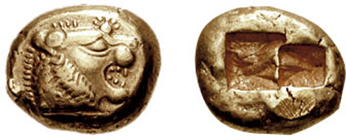
According to Herodotus, the Lydians were the first people to use gold and silver coins and the first to establish retail shops in permanent locations. It is not known, however, whether Herodotus meant that the Lydians were the first to use coins of pure gold and pure silver or the first precious metal coins in general. Despite this ambiguity, this statement of Herodotus is one of the pieces of evidence most often cited on behalf of the argument that Lydians invented coinage, at least in the West, although the first coins (under Alyattes I, reigned c.591–c.560 BC) were neither gold nor silver but an alloy of the two called electrum.
The first Jews in Lydia were set up by Antiochus III in the wake of a revolt in Lydia and Phrygia from 209–204 BC and consisted of 2000 Jewish families who lived in military settlements in Lydia and Phrygia. Each of these families were given land where they would build a house and cultivate the rest as farmland, they would also be given a 10 year tax exemption and have their basic needs provided for them by the government to help them establish themselves. Once they were established, the Jews of Lydia were given special autonomy to practice Judaism and the Lydian settlements became the epicenter of Judaism across Asia Minor.
Read more
Lydia remained under the control of the Selucids until the Battle of Magnesia in 190 BC when it was given to king Eumenes of Pergamum. in 133 BC Attalus III bequeathed the kingdom to the Romans.
The Kingdom of Bithynia (Ancient Greek: Βιθυνία) was a Hellenistic kingdom centred in the historical region of Bithynia, in northwest Anatolia, which seems to have been established in the 4th century BC. In the midst of the Wars of the Diadochi, Zipoites assumed the Greek title of basileus (meaning king) in 297 BC.
His son and successor, Nicomedes I, founded Nicomedia, which soon rose to great prosperity.
The population of Bithynia is thought to have been of Thracian origin. According to Memnon of Heraclea, the native prince Bas of Bithynia managed to defeat Alexander the Great's general Calas in battle (probably around 330 BC). His son Zipoites I assumed the Greek title basileus (meaning "king") in 297 BC.
Read more
His son and successor, Nicomedes I, founded Nicomedia, which soon rose to great prosperity, and during his long reign (c. 278 – c. 255 BC), Bithynia developed considerable standing and influence among the minor monarchies of Anatolia.
Koine Greek, Bithynian language, Phrygian language
Wars and Battles
Relations between Bithynia and Rome soured during the reign of Nicomedes II's son and successor Nicomedes III over the influence over the central Anatolian kingdom of Cappadocia.
Read more
Becoming king in 127 BC, Nicomedes III conquered Paphlagonia along the Black Sea and began to expand his influence over the Roman ally of Cappadocia. In 116 BC, the Cappadocian king Ariarathes VI was murdered by the Cappadocian noble Gordius on orders from King Mithridates VI of Pontus. Mithridates VI then installed his sister Laodice of Cappadocia, Ariarathes VI's widow, as regent over for the infant Ariarathes VII, ensuring Pontic control over Cappadocia in the process.
Nicomedes III sought to take advantage of the political power vacuum in Cappadocia, invaded the kingdom, and refused to recognize the infant Ariarathes VII as Cappadocia's legitimate ruler.
281 BCE – 67 CE · Capital: Amaseia, Sinope · 584,683 km²
Mithridates V of Pontus (157-121 BC) Evergete=Benefactor. 150-125 BC. Louvre museum (Paris, France).Tangopaso · Public domain · Commons
Pontus (Ancient Greek: Πόντος Pontos, sea) was a Hellenistic kingdom centered in the historical region of Pontus, in northern Anatolia, on the southern coast of the Black Sea (Ancient Greek: Εύξεινος Πόντος, literally meaning "hospitable sea").
It was ruled by the Mithridatic dynasty of Persian origin, which may have been directly related to Darius the Great of the Achaemenid dynasty.
The kingdom was proclaimed by Mithridates I in 281 BC and lasted until its conquest by the Roman Republic in 63 BC.
Koine Greek (official after 3rd century BC), Ionic Greek (in coastal cities), Persian (dynastic), Armenian (after 115 BC) and Anatolian (regional)
Religion
Syncretic Hellenistic religion, incorporating Greek polytheism, Iranian religion, and local Anatolian religion.
Wars and Battles
The treaty agreed with Sulla was not to last. From 83 to 82 BC Mithridates fought against and defeated Licinius Murena, who had been left by Sulla to organize the province of Asia. The so-called Second Mithridatic war ended without any territorial gains by either side. The Romans now began securing the coastal region of Lycia and Pamphylia from pirates and established control over Pisidia and Lycaonia. When in 74 the consul Lucullus took over Cilicia, Mithridates faced Roman commanders on two fronts. The Cilician pirates had not been completely defeated, and Mithridates signed an alliance with them. He was also allied with the government of Quintus Sertorius in Spain and with his help reorganized some of his troops in the Roman legionary pattern with short stabbing swords.
A view of the remnants of the Temple of Augustus in Ankara, Turkey (Monumentum Ancyranum). Photo taken by AtilimGunesBaydin on November 28, 2004.No machine-readable author provided. Ori~ assumed (based on copyright claims). · Public domain · Commons
Galatia (Ancient Greek: Γαλατία, Galatía, Turkish: Galatya), also called Gallograikia (Ancient Greek: Γαλλογραικία), was an ancient area in the highlands of central Anatolia, roughly corresponding to the provinces of Ankara and Eskişehir in modern Turkey. Galatia was named after the Gauls from Thrace (cf. Tylis), who settled here and became a small transient foreign tribe in the 3rd century BC, following the Gallic invasion of the Balkans in 279 BC.
279 BCE – 127 BCE · Capital: Pergamon, (modern-day Bergama, İzmir Province, Turkey) · 176,006 km²
Columns in the Temple of Trajan, Pergamon, TurkeyBernard Gagnon · CC BY-SA 3.0 · Commons
The Kingdom of Pergamon, Pergamene Kingdom, or Attalid kingdom was a Greek state during the Hellenistic period that ruled much of the Western part of Asia Minor (now Turkey) from its capital city of Pergamon. It was ruled by the Attalid dynasty (Greek: Δυναστεία τῶν Ἀτταλιδῶν, romanized: Dynasteía ton Attalidón).
The kingdom was a rump state that was created from the territory ruled by Lysimachus, a general of Alexander the Great. Philetaerus, one of Lysimachus' lieutenants, rebelled and seized the city of Pergamon and the surrounding regions; Lysimachus died soon after in 281 BC.
Two notable cults in early Pergamon were the cult of the Cabiri, a pantheon likely of original Phrygian or Thracian origin that became syncretized with Greek beliefs and mythology, and the Corybantes, worshippers of the mother goddess Cybele (possibly the Asia Minor equivalent of the Greek goddess Rhea). Various art and statues were built to them. The worship of Cybele would later intersect with Roman history. According to Livy, during the Second Punic War between Rome and Carthage (205 BC), the Sibylline Oracle told the Senate that Carthage would be defeated if the cult of the Mater Deum Magna Idaea (Magna Mater = "Great Mother") was imported into Rome. At the time, Pergamon was Rome's closest ally in the region of the Greek Eastern Mediterranean, and they sought out artifacts from the region that matched the request, where the closest equivalent goddess was Cybele.
After the Pergamene expansion in size and prestige in the early 2nd century BC, King Eumenes II embarked upon a vast building program in Pergamon to suit the capital's new prominence. He expanded the Library of Pergamon that had probably been started by his father Attalus I, which adjoined the newly created Temple to Athena noted above. He also began construction of the great Pergamon Altar in the late 180s BC.
Read more
The Attalids also engaged in significant construction activity in many other cities within their domain. However, no specific ‘Attalid’ style can be identified in terms of architecture.
Cities namend after the Attalids were Attalea in Lydia, now Yanantepe, and Attalea in Pamphylia, now Antalya.
Sunset in Amasra. Photo by Eylem Dal.No machine-readable author provided. Bertilvidet~commonswiki assumed (based on copyright claims). · CC BY 2.5 · Commons
Paphlagonia (Greek: Παφλαγονία, romanized: Paphlagonía, modern translit. Paflagonía; Turkish: Paflagonya) was an ancient region on the Black Sea coast of north-central Anatolia, situated between Bithynia to the west and Pontus to the east, and separated from Phrygia (later, Galatia) by a prolongation to the east of the Bithynian Olympus. According to Strabo, the region was bounded by the river Parthenius to the west and the Halys River to the east.
Paphlagonia was said to be named after Paphlagon, a son of the mythical Phineus.
256 BCE – 113 CE · Capital: Karkathiokerta, Arsamosata · 23,785 km²
The Kingdom of Sophene (Armenian: Ծոփք, romanized: Tsop’k’, Ancient Greek: Σωφηνή, romanized: Sōphēnḗ) was a Hellenistic-era political entity situated between ancient Armenia and Syria. Its territory was once a part of the Satrapy of Armenia, which was ruled by the Orontid dynasty, and it emerged as a separate kingdom in the 3rd century BCE under a branch of that dynasty. The kingdom maintained independence until c. 95 BCE when the Artaxiad king Tigranes the Great conquered the territories as part of his empire.
The Kingdom of Sophene was ruled by the Orontids, a dynasty of Iranian origin which ruled the Satrapy of Armenia under the Achaemenid Empire. They were descended from Orontes I, a Bactrian nobleman who was the son-in-law of the Achaemenid King of Kings Artaxerxes II (r. 404–358 BCE). The Orontids maintained their control over Armenia following the conquest of the Achaemenid Empire by Alexander the Great in 330 BCE, effectively ruling Armenia as kings. Most scholars concur that Sophene formed part of the Satrapy of Armenia in the Achaemenid period. In the Hellenistic period, the western regions of Armenia may have been more under the control of the Seleucids while the Orontids maintained control over the eastern regions of Armenia.
Armenian was the common language spoken by the people of Sophene. However, as late as the first half of the 2nd century BCE, Imperial Aramaic (with a fairly strong admixture of Persian terms), was used in governmental and court proceedings, which was rooted in Achaemenid practices from Armenia.
Imperial Aramaic (government, court), Armenian (lingua franca)
Religion
Zoroastrianism
Economy and Trade
Similar to the early Arsacids of Parthia and Frataraka of Persis, the Orontids of Sophene experimented with images of Iranian royal power. On his coins, Sames I (fl. 260 BCE) is shown as clean-shaven and wearing the kyrbasia, a type of headgear originally worn by the satraps of the Achaemenid Empire. The tip of Sames's kyrbasia is more prominent, similar to that of the headgear worn by the early Ariarathids of Cappadocia. On the coins of Xerxes (fl. 220 BCE), he is shown bearded and wearing a diademed kyrbasia, which represented a new imagery of Iranian royal power.
The Orontid dynasty in Sophene practiced Zoroastrianism. According to modern historian Michał Marciak, the well-attested existence of Iranian culture in Sophene could be understood, as it was by Nina Garsoïan, as a derivation of Greater Armenia and indirectly from Iran. He also considers it possible that the strong existence of Iranian culture might have influenced Roman and Greek writers to regard the region as Armenian. The Orontids of Sophene "engaged or reinvigorated certain regional traditions of their Persian satrapal ancestors to give their fledgling kingdom the perception of depth." Furthermore, with the names of the royal members of the family including the names of their newfound cities, the Orontids emphasized their Achaemenid and Orontid royal dynastic aspirations, and also their Iranian cultural background.
Cappadocia (Greek: Καππαδοκία) was a Hellenistic-era Iranian kingdom centered in the historical region of Cappadocia in Asia Minor (present-day central Turkey).
It developed from the former Achaemenid satrapy of Cappadocia, and it was founded by its last satrap, Ariarathes (later Ariarathes I). Throughout its history, it was ruled by three families in succession: the House of Ariarathes (331–96 BC), the House of Ariobarzanes (96–36 BC), and lastly that of Archelaus (36 BC–17 AD). The Cappadocian kings Hellenized various aspects of the kingdom on purpose.
Under the Achaemenids, the "Iranization" of Asia Minor had been significant, and a large Iranian presence had been established in western Asia Minor, Pontus and Cappadocia. Ariarathes had been satrap of Cappadocia for 19 years and a loyal supporter of the Achaemenid kings. By blood, he was related to the ruling Achaemenid house ("Cyrus and Darius’ Seven") as well as other satraps. When Alexander the Great invaded Cappadocia as part of his conquest of the Persian Empire, he appointed two temporary governors. For the Iranians in Asia Minor, "as perhaps everywhere", the fall of the Achaemenids "meant crisis". With the victory of Alexander and the emergence of Hellenistic successor kings, the Iranians in Caria and "probably throughout western Asia Minor" eventually started to adapt themselves to the changing situation.
Initially, the kingdom was organized in ten satrapies. Later, this became eleven. The satrapies were called by the Greek term strategiai, and each of them were headed by the strategos, basically an important noble. The eleven satrapies were; Melitene, Cataonia, Cilicia, Tyanitis, Garsauritis, Laouiansene, Sargarausene, Saraouene, Chamanene, Morimene, and Cilicia Tracheia. Cilicia Tracheia, the eleventh and last satrapy, was added later to the kingdom.
Read more
Control over the lands of the kingdom was maintained through royal estates and fortifications protected and maintained by nobility. There were two types of estates: those located and centered on the residence of the noble in question (whose power, as the Encyclopedia Iranica adds, "was foremost temporal") and the so-called temple estates.
Blick vom höchsten Punkt auf dem Glockenturrm des "ROLOI" Uhrturm in der Altstadt von Rhodos.Böhringer Friedrich · CC BY-SA 2.5 · Commons
Rhodes (Greek: Ρόδος, romanized: Ródos [ˈroðos]) is the largest of Greece's Dodecanese islands and their historical capital, as well as the ninth largest island in the Mediterranean Sea. Administratively, Rhodes constitutes a municipality within the Rhodes regional unit, which is part of the South Aegean administrative region. The principal town of the island and seat of the municipality is the city of Rhodes, home to 50,636 inhabitants according to the 2011 census. By 2022, the island's population had grown to 125,113 people.
During the Late Pleistocene, the island was inhabited by an unnamed species of dwarf elephant. The island has been inhabited by humans since at least the late Neolithic, as evidenced by remains found at Kalythies cave on the northeast of the island.
The municipality has an area of 1400.681 km2. It covers the island of Rhodes and a few uninhabited offshore islets. Rhodes city was the capital of the former Dodecanese Prefecture. Rhodes is the most populated island of the South Aegean Region.
The economy is tourist-oriented, and the most developed sector is service. Tourism has elevated Rhodes economically, compared to the rest of Greece.
Read more
Small industries process imported raw materials for local retail, though other industry includes agricultural goods production, stockbreeding, fishery and winery.
Flag of Rhodes IslandTakisA1, Ancient Design found on coins [1] · Public domain · Commons
Wars and Battles
Following the Italian Armistice of 8 September 1943, the British attempted to get the Italian garrison on Rhodes to change sides. This was anticipated by the German Army, which succeeded in occupying the island with the Battle of Rhodes. In great measure, the German occupation caused the British failure in the subsequent Dodecanese Campaign.
Read more
After September 1943, the Jews were sent to concentration camps. However, the Turkish Consul Selahattin Ülkümen succeeded, at considerable risk to himself and his family, in saving 42 Jewish families, about 200 persons in total, who had Turkish citizenship or were members of Turkish citizens' families.
On 8 May 1945, the Germans under Otto Wagener surrendered Rhodes as well as the Dodecanese as a whole to the British, who soon after then occupied the islands as a military protectorate.
Gordyene or Corduene (Ancient Greek: Γορδυηνή, romanized: Gordyēnḗ or Κορδυηνή, Kordyēnḗ; Armenian: Կորդուք, romanized: Korduk'; Hebrew: קרטיגיני, romanized: Kartigini; Classical Syriac: Beth Qardu) was an ancient historical region, located on the upper course of the Tigris, south of Lake Van, in present-day southeastern Turkey.
Gordyene was situated between the countries of Armenia, Adiabene, and Atropatene. Since antiquity, the people of Gordyene have been identified with the Karduchoi, a people who inhabited the mountainous area south of the Botan River c. 401 BC.
In the period between the collapse of Seleucid power and conquest of Mesopotamia by the Parthians (i.e. sometime between 165–164 BC and 95 BC), the Karduchoi established an independent kingdom. Gordyene came under Parthian rule either in about 145–141 BCE, together with neighboring Adiabene, or later, during the reign of the Parthian king Mithradates II (122–87 BC); Marciak considers the latter option more probably.
Read more
Gordyene was vassalized by the Armenian king Tigranes the Great (r. 95–55 BC), who expanded it by taking territory from Parthian Adiabene. According to Plutarch's Life of Lucullus, the Gordyeni were one of the peoples whose cities Tigranes destroyed so that their inhabitants could populate his new capital of Tigranocerta. The only king of Gordyene who is explicitly identified in ancient sources, Zarbienus, was dethroned and killed by Tigranes in the winter of 71/70 BC.
Ancient States of Anatolia and Cyprus: Frequently Asked Questions
Which states existed in Anatolia and Cyprus in this period?
This page maps 15 states of Anatolia and Cyprus founded between 1600 BCE and 63 BCE: Hittites, Neo-Hittite states, Greek Dark Ages, Phrygia, Tabal Kingdom, Lydia, Kingdom of Bithynia, Kingdom of Pontus, Galatia, Kingdom of Pergamon, Paphlagonia, Kingdom of Sophene and 3 more.
Which was the largest of the Ancient States of Anatolia and Cyprus?
Kingdom of Pontus had the largest mapped extent, about 584,683 km².
Which of the Ancient States of Anatolia and Cyprus lasted longest?
Hittites lasted longest, 1600 BCE – 1151 BCE.
↑↓ to navigate↵ to open
12,754 Planetary Entities Indexed
We use Google Analytics cookies to understand which pages are useful. Necessary storage only keeps your theme and this choice on your device. Privacy policy