Skip to content
YearMaps
5 states3200 BCE – 259 CE

Ancient States of Persia and Afghanistan: Map & History

5 states of Persia and Afghanistan on one map, from 3200 BCE to 259 CE.The largest, Parthian Empire, covered about 3,053,740 km²; the longest-lived, Elam, lasted 3200 BCE – 601 BCE. Each has its own section below with its rulers, capitals, wars and pictures where the records hold them.

Statue de Napir-Asu - Musée du Louvre - Antiquités orientales SB 2731 - photo 2
Shonagon · CC0 · Commons
Ardabil
Bahram Adshirinpur · CC BY 4.0 · Commons
Coin of Arsaces I, Nisa mint.
Classical Numismatic Group; [1] · CC BY-SA 3.0 · Commons
Bagram, Afghanistan. This is a photograph of the bazaar in Bagram city.
JE at English Wikipedia · CC BY 3.0 · Commons
Base map
3200 BC
225 BC
259 AD
3200 BC
2500 BC
2000 BC
1000 BC
500 BC
259 AD
Epochs:
↗
↗
↗
↗
↗
↗
↗
↗

Each state in its own colour. Move the timeline to see which existed in any year from 3200 BC to 259 AD; select a territory to read about it. Borders: Cliopatria / Seshat (CC BY 4.0).

The Ancient States of Persia and Afghanistan Compared

StateYearsCapitalLargest extentRulers
Elam3200 BCE – 601 BCEAnshan Persia215,100 km²5
Median Kingdom615 BCE – 551 BCEEcbatana2,243,378 km²2
Atropatene307 BCE – 165 BCEGanzak147,253 km²1
Parthian Empire239 BCE – 237 CECtesiphon, Ecbatana, Hecatompylos, Susa, Mithradatkirt, Asaak, Rhages3,053,740 km²1
Western Kushans238 CE – 259 CE1st Century BCE: Kapisa/Pushkalavati;, from 1st century CE: Purushapura/Mathura, 3rd and 4th centuries CE: Taxila684,686 km²6

Timeline of the Ancient States of Persia and Afghanistan

When each state existed, 3200 BCE to 259 CE. Select a year to see the map then.

  1. Elam
    3200 BCE – 601 BCE
  2. Median Kingdom
    615 BCE – 551 BCE
  3. Atropatene
    307 BCE – 165 BCE
  4. Parthian Empire
    239 BCE – 237 CE
  5. Western Kushans
    238 CE – 259 CE

The 5 States

Elam

3200 BCE – 601 BCE · Capital: Anshan Persia · 215,100 km²

Statue de Napir-Asu - Musée du Louvre - Antiquités orientales SB 2731 - photo 2
Statue de Napir-Asu - Musée du Louvre - Antiquités orientales SB 2731 - photo 2 Shonagon · CC0 · Commons

Elam was an ancient civilization centered in the far west and southwest of Iran, stretching from the lowlands of Ilam and Khuzestan as well as a small part of modern-day southern Iraq. The modern name Elam stems from the Sumerian transliteration elam(a), along with the later Akkadian elamtu, and the Elamite haltamti. Elamite states were among the leading political forces of the Ancient Near East. In classical literature, Elam was also known as Susiana (US: UK:; Ancient Greek: Σουσιανή Sousiānḗ), a name derived from its capital Susa.

From Wikipedia: Elam (CC BY-SA 4.0)

Origins and Founding

Founded
3200 BCE

Capitals

The Apadana, a large hypostyle room of 36 columns in the Palace of Darius, Susa, capital of Elam and of the Achaemenid Empire, Iran
The Apadana, a large hypostyle room of 36 columns in the Palace of Darius, Susa, capital of Elam and of the Achaemenid Empire, Iran Carole Raddato from Frankfurt, Germany · CC BY-SA 2.0 · Commons
Anshan Persia
Capital

Rulers

Government, Society and Religion

The Elamites practised polytheism. Due to scarcity of sources, past scholars assumed that Elamite religion must have been characterized by the "ill-defined character of the individual gods and goddesses....Most of them were not only ineffable beings whose real name was either not uttered or was unknown, but also sublime ideas, not to be exactly defined by the human race." Worship also varied between localities. However, more recent scholarship shows that Elamite deities most likely were not any less defined than those of their Sumerian, Akkadian and Hurrian neighbors.

Read more

Inscriptions of many Elamite kings indicate that a concept of a supreme triad consisting of Inshushinak (originally the civic protector god of Susa, eventually the leader of the triad and guarantor of the monarchy), Kiririsha (an earth/mother goddess in southern Elam), and Napirisha existed.

From Wikipedia: Elam · Religion (CC BY-SA 4.0)

Economy and Trade

Many archaeological finds suggest that maritime trade along the shores of Africa and Asia started several millennia ago. Trade between the Indus Valley Civilization and the cities of Mesopotamia and Elam can be inferred from numerous find of Indus artifacts, particularly in the excavation at Susa. Various objects made with shell species that are characteristic of the Indus coast, particularly Trubinella pyrum and Fasciolaria trapezium, have been found in the archaeological sites of Mesopotamia and Susa dating from around 2500–2000 BC. Carnelian beads from the Indus were found in Susa in the excavation of the tell of the citadel. In particular, carnelian beads with an etched design in white were probably imported from the Indus Valley, and made according to a technique of acid-etching developed by the Harappans.

From Wikipedia: Elam · History: Trade with the Indus Valley Civilization (CC BY-SA 4.0)

Wars and Battles

Achievements and Monuments

Dated to approximately the 12th century BC, gold and silver figurines of Elamite worshippers are shown carrying a sacrificial goat. These divine and royal statues were meant to assure the king of the enduring protection of the deity, well-being and a long life. Works which showed a ruler and his performance of a ritual action were intended to eternalize the effectiveness of such deeds. Found near the Temple of Inshushinak in Susa, these statuettes would have been considered charged with beneficial power.

Read more

While archaeologists cannot be certain that the location where these figures were found indicates a date before or in the time of the Elamite king Shilhak-Inshushinak, stylistic features can help ground the figures in a specific time period.

From Wikipedia: Elam · Art: Statuettes (CC BY-SA 4.0)

Decline and Fall

Ended
601 BCE
Succeeded by
Achaemenid Empire

Legacy in the Modern World

The Assyrians had utterly destroyed the Elamite nation, but new polities emerged in the area after Assyrian power faded. Some time after that region fell to Madius the Scythian (653 BC), Teispes, son of Achaemenes, conquered Elamite Anshan in the mid 7th century BC, forming a nucleus that would expand into the Persian Empire. They were largely regarded as vassals of the Assyrians, and the Medes, Mannaeans, and Persians paid tribute to Assyria from the 10th century BC until the death of Ashurbanipal in 631 BC. After his death, the Medes played a major role in the destruction of the weakened Assyrian Empire in 612 BC.

Read more

The rise of the Achaemenids in the 6th century BC brought an end to the existence of Elam as an independent political power "but not as a cultural entity" (Encyclopædia Iranica, Columbia University).

From Wikipedia: Elam · Legacy (CC BY-SA 4.0)

Median Kingdom

615 BCE – 551 BCE · Capital: Ecbatana · 2,243,378 km²

Media (Old Persian: 𐎶𐎠𐎭 Māda; Greek: Μηδία Mēdía; Akkadian: Mādāya) was a political entity centered in Ecbatana that existed from the 7th century BC until the mid-6th century BC and is believed to have dominated a significant portion of the Iranian plateau, preceding the powerful Achaemenid Empire. The frequent interference of the Assyrians in the Zagros region led to the process of unifying the Median tribes. By 612 BC, the Medes became strong enough to overthrow the declining Assyrian empire in alliance with the Babylonians.

From Wikipedia: Median dynasty (CC BY-SA 4.0)

Rulers

  • Deioces
  • Phraortes

Government, Society and Religion

Government
Monarchy
Languages
Median
Religion
Ancient Iranian religion

Atropatene

307 BCE – 165 BCE · Capital: Ganzak · 147,253 km²

Ardabil
Ardabil Bahram Adshirinpur · CC BY 4.0 · Commons

Atropatene (Old Persian: Ātṛpātakāna; Middle Persian: Ādurbādagān; Ancient Greek: Ἀτροπατηνή), also known as Atropatia or Atropatian Media (Ancient Greek: Ἀτροπάτιος Μηδία, romanized: Atropátios Mēdía; Latin: Media Atropatene), was an ancient Iranian kingdom established in c. 323 BC by the Persian satrap Atropates (Old Persian: *Ātṛpāta). The kingdom, mostly centered around the present-day Azerbaijan region in northwestern Iran, was ruled by Atropates' descendants until the early 1st-century AD, when the Parthian Arsacid dynasty supplanted them.

From Wikipedia: Atropatene (CC BY-SA 4.0)

Capitals

This is a photo of a monument in Iran identified by the ID
This is a photo of a monument in Iran identified by the ID Babak.golparian · CC BY-SA 4.0 · Commons
Ardabil
Capital
Ganzak
Capital

Rulers

Government, Society and Religion

Government
Monarchy
Languages
Iranian language
Religion
Zoroastrianism

Wars and Battles

Decline and Fall

Ended
165 BCE
Succeeded by
Azerbaijan (Iran)

Legacy in the Modern World

Atropatene was the only Iranian region to remain under Zoroastrian authority from the Achaemenids to the Arab conquest without any interruption, aside from being briefly ruled by the Macedonian king Alexander the Great (r. 336–323 BC). Under the Atropatids, the region successfully managed to gain a dominant place in Zoroastrianism, which would continue into the Sasanian period, whose monarchs favored Median traditions over that of the Parthians. Moreover, Atropatene also served as a stronghold of Iranian culture.

From Wikipedia: Atropatene · Legacy (CC BY-SA 4.0)

Parthian Empire

239 BCE – 237 CE · Capital: Ctesiphon, Ecbatana, Hecatompylos, Susa, Mithradatkirt, Asaak, Rhages · 3,053,740 km²

Coin of Arsaces I, Nisa mint.
Coin of Arsaces I, Nisa mint. Classical Numismatic Group; [1] · CC BY-SA 3.0 · Commons

The Parthian Empire, also known as the Arsacid Empire, was a major Iranian political and cultural power centered in ancient Iran from 247 BC to 224 AD. Its latter name comes from its founder, Arsaces I, who led the Parni tribe in conquering the region of Parthia in Iran's northeast, then a satrapy (province) under Andragoras, who was rebelling against the Seleucid Empire. Mithridates I (r. c. 171 – 132 BC) greatly expanded the empire by seizing Media and Mesopotamia from the Seleucids.

From Wikipedia: Parthian Empire (CC BY-SA 4.0)

Origins and Founding

Before Arsaces I founded the Arsacid dynasty, he was chieftain of the Parni, an ancient Central Asian tribe of Iranian peoples and one of several nomadic tribes within the confederation of the Dahae. The Parni most likely spoke an eastern Iranian language, in contrast to the northwestern Iranian language spoken at the time in Parthia. The latter was a northeastern province, first under the Achaemenid Empire, and then the Seleucid Empire. After conquering the region, the Parni adopted Parthian as the official court language, speaking it alongside Middle Persian, Aramaic, Greek, Babylonian, Sogdian and other languages in the multilingual territories they would conquer. Some academics debate the ethnic origins of Arsaces I, such as Hashem Kazemi and Mostafa Dehpahlavan, who argue that he was a Parthian native rather than a member of the invading Parni.

From Wikipedia: Parthian Empire · History: Origins and establishment (CC BY-SA 4.0)

Founder
Arsaces I of Parthia
Founded
239 BCE

Capitals

Ctesiphon
Ctesiphon Unknown author · Public domain · Commons
Ctesiphon
Capital
Seleucia
Capital
Hecatompylos
Capital

Rulers

Government, Society and Religion

The Parthian Empire had no standing army, yet were able to quickly recruit troops in the event of local crises. There was a permanent armed guard attached to the person of the king, comprising nobles, serfs and mercenaries, but this royal retinue was small. Garrisons were also permanently maintained at border forts; Parthian inscriptions reveal some of the military titles granted to the commanders of these locations. Military forces could also be used in diplomatic gestures. For example, when Chinese envoys visited Parthia in the late 2nd century BC, the Shiji maintains that 20,000 horsemen were sent to the eastern borders to serve as escorts for the embassy, although this figure is perhaps an exaggeration.

Read more

The main striking force of the Parthian army was its cataphracts, heavy cavalry with man and horse decked in mailed armor.

From Wikipedia: Parthian Empire · Government and administration: Military (CC BY-SA 4.0)

Government
Monarchy
Languages
Greek (official)., Aramaic (lingua franca)
Religion
Babylonian religion., Buddhism

Coins, Currency and Symbols

Coin of the Parthian king Mithradates II (123-88 B.C.)
Coin of the Parthian king Mithradates II (123-88 B.C.) Classical Numismatic Group; [1] · CC BY-SA 3.0 · Commons
Currency
Parthian coins
  • Iscrizione del potere dell'Impero Partico sul rovescio di una moneta di Pacoro I
    Iscrizione del potere dell'Impero Partico sul rovescio di una moneta di Pacoro I Starnutoditopo · CC BY-SA 4.0 · Commons

Wars and Battles

Achievements and Monuments

Parthian art can be divided into three geo-historical phases: the art of Parthia proper; the art of the Iranian plateau; and the art of Parthian Mesopotamia. The first genuine Parthian art, found at Mithridatkert/Nisa, combined elements of Greek and Iranian art in line with Achaemenid and Seleucid traditions. In the second phase, Parthian art found inspiration in Achaemenid art, as exemplified by the investiture relief of Mithridates II at Mount Behistun. The third phase occurred gradually after the Parthian conquest of Mesopotamia.

Read more

Common motifs of the Parthian period include scenes of royal hunting expeditions and the investiture of Arsacid kings. Use of these motifs extended to include portrayals of local rulers. Common art mediums were rock-reliefs, frescos, and even graffiti. Geometric and stylized plant patterns were also used on stucco and plaster walls.

From Wikipedia: Parthian Empire · Society and culture: Art and architecture (CC BY-SA 4.0)

Decline and Fall

After the Iberian king Pharasmanes I had his son Rhadamistus (r. 51–55 AD) invade Armenia to depose the Roman client king Mithridates, Vologases I of Parthia (r. c. 51–77 AD) planned to invade and place his brother, the later Tiridates I of Armenia, on the throne. Rhadamistus was eventually driven from power, and, beginning with the reign of Tiridates, Parthia would retain firm control over Armenia—with brief interruptions—through the Arsacid dynasty of Armenia. Even after the fall of the Parthian Empire, the Arsacid line lived on through the Armenian kings. However, not only did the Arsacid line continue through the Armenians, it also continued through the Georgian kings with the Arsacid dynasty of Iberia, and for many centuries afterwards in Caucasian Albania through the Arsacid dynasty of Caucasian Albania.

From Wikipedia: Parthian Empire · History: Continuation of Roman hostilities and Parthian decline (CC BY-SA 4.0)

Ended
237 CE
Last recorded ruler
Musa of Parthia

Western Kushans

238 CE – 259 CE · Capital: 1st Century BCE: Kapisa/Pushkalavati;, from 1st century CE: Purushapura/Mathura, 3rd and 4th centuries CE: Taxila · 684,686 km²

Bagram, Afghanistan. This is a photograph of the bazaar in Bagram city.
Bagram, Afghanistan. This is a photograph of the bazaar in Bagram city. JE at English Wikipedia · CC BY 3.0 · Commons

The Kushan Empire (c. 30–c. 375 CE) was a syncretic empire formed by the Yuezhi in the early 1st century CE. Initially based in the Bactrian territories, it spread to encompass much of what is now Afghanistan, India, Pakistan, Tajikistan, Turkmenistan and Uzbekistan. Kushan territory in India extended at least as far as Saketa and Sarnath near Varanasi, where inscriptions have been found dating to the era of the Kushan emperor Kanishka the Great.

From Wikipedia: Kushan Empire (CC BY-SA 4.0)

Origins and Founding

Chinese sources describe the Guìshuāng (貴霜, Old Chinese: *kuj-s raŋ), i.e. the Kushans, as one of the five aristocratic tribes of the Yuezhi. Many scholars believe that the Yuezhi were a people of Indo-European origin. A number of scholars have suggested a specifically Tocharian origin of the Yuezhi. An Iranic Saka origin has also been suggested by some scholars.

Read more

The Yuezhi were described in the Records of the Great Historian and the Book of Han as living in the grasslands of eastern Xinjiang and northwestern part of Gansu, in the northwest of modern-day China, until their King was beheaded by the Xiongnu (匈奴) who were also at war with China, which eventually forced them to migrate west in 176–160 BC. The five tribes constituting the Yuezhi are known in Chinese history as Xiūmì (休密), Guìshuāng (貴霜), Shuāngmǐ (雙靡), Xìdùn (肸頓), and Dūmì (都密).

From Wikipedia: Kushan Empire · Origins (CC BY-SA 4.0)

Founded
238 CE

Rulers

Government, Society and Religion

The Kushans inherited the Greco-Buddhist traditions of the Indo-Greek Kingdom they replaced, and their patronage of Buddhist institutions allowed them to grow as a commercial power. Between the mid-1st century and the mid-3rd century, Buddhism, patronised by the Kushans, extended to China and other Asian countries through the Silk Road. Kanishka in particular is well-known in Buddhist tradition for having convened a great Buddhist council in Kashmir.

Read more

During the 1st century AD, Buddhist books were being produced and carried by monks, and their trader patrons. Also, monasteries were being established along these land routes that went from China and other parts of Asia. With the development of Buddhist books, it caused a new written language called Gandhara. Gandhara consists of eastern Afghanistan and northern Pakistan.

From Wikipedia: Kushan Empire · Religion: Buddhism (CC BY-SA 4.0)

Government
Monarchy
Languages
Greek (official until)), discarded Greek (Ionian) as the language of administration and adopted Bactrian ("Arya language")., Bactrian (official from), Gandhari Prakrit, Hybrid Sanskrit
Religion
Hinduism, Buddhism, Zoroastrianism

Coins, Currency and Symbols

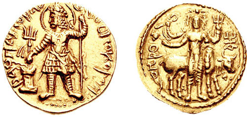
Coin of Kushan empire, King Vasudeva II
Coin of Kushan empire, King Vasudeva II anonymous · CC0 · Commons
Currency
Kushan coinage
  • Coin: Havishka (reverse) title QS:P1476,en:"Coin: Havishka (reverse) "label QS:Len,"Coin: Havishka (reverse) "label QS:Lfr,"pièce d'or de l'empire Kushan du roi Havishka"
    Coin: Havishka (reverse) title QS:P1476,en:"Coin: Havishka (reverse) "label QS:Len,"Coin: Havishka (reverse) "label QS:Lfr,"pièce d'or de l'empire Kushan du roi Havishka" anonymous · CC0 · Commons
  • Coin of Kushan empire, King Vasudeva I
    Coin of Kushan empire, King Vasudeva I anonymous · CC0 · Commons
  • Coin of Kushan King Vima Kadphises
    Coin of Kushan King Vima Kadphises anonymous · CC0 · Commons

Wars and Battles

Achievements and Monuments

The Kushans adopted elements of the Hellenistic culture of Bactria. They adopted the Greek alphabet to suit their own language (with the additional development of the letter Þ "sh", as in "Kushan") and soon began minting coinage on the Greek model. On their coins they used Greek language legends combined with Pali legends (in the Kharosthi script), until the first few years of the reign of Kanishka. After the middle of Kanishka's reign, they used Kushan language legends (in an adapted Greek script), combined with legends in Greek (Greek script) and legends in Prakrit (Kharoshthi script).

Read more

Interestingly there is evidence for the collaboration between Greek populations and the Kushans in the 2nd century AD. Apparently the main architect of the Kushan temple at Surkh Kotal was a Greek named Palamedes.

From Wikipedia: Kushan Empire · Culture (CC BY-SA 4.0)

Decline and Fall

Ended
259 CE
Succeeded by
Kidarites
Succeeded by
Gupta Empire

Ancient States of Persia and Afghanistan: Frequently Asked Questions

Which states existed in Persia and Afghanistan in this period?

This page maps 5 states of Persia and Afghanistan founded between 3200 BCE and 238 CE: Elam, Median Kingdom, Atropatene, Parthian Empire, Western Kushans.

Which was the largest of the Ancient States of Persia and Afghanistan?

Parthian Empire had the largest mapped extent, about 3,053,740 km².

Which of the Ancient States of Persia and Afghanistan lasted longest?

Elam lasted longest, 3200 BCE – 601 BCE.

Sources

  • Reading text: Wikipedia articles on the group and each state, condensed (CC BY-SA 4.0).
  • Facts, rulers and wars: Wikidata (CC0).
  • Borders: Cliopatria, Seshat Global History Databank (CC BY 4.0).
  • Pictures: Wikimedia Commons; the author and licence are under each picture.

Largest state by mapped extent: Parthian Empire.