Skip to content
YearMaps
8 states555 CE – 1546 CE

Medieval States of Mesoamerica and the Caribbean: Map & History

8 states of Mesoamerica and the Caribbean on one map, from 555 CE to 1546 CE.The largest, Crown of Castile, covered about 535,551 km²; the longest-lived, Later Mayan City-States, lasted 850 CE – 1546 CE. Each has its own section below with its rulers, capitals, wars and pictures where the records hold them.

El Tajín 1
Unknown author · CC BY-SA 2.0 · Commons
El Castillo, Chichén Itzá
Unknown author · CC BY-SA 3.0 · Commons
Toltec Gallery, INAH, National Museum of Anthropology, Mexico City. Complete indexed photo collection at WorldHistoryPics.com.
Gary Todd · CC0 · Commons
A nice view of numerous fine buildings with exterior balconies in Madrid, Spain.
Dmitry Dzhus from London · CC BY 2.0 · Commons
Base map
555 AD
1330 AD
1546 AD
555 AD
800 AD
1000 AD
1100 AD
1300 AD
1546 AD
Epochs:
↗
↗
↗
↗
↗
↗
↗
↗

Each state in its own colour. Move the timeline to see which existed in any year from 555 AD to 1546; select a territory to read about it. Borders: Cliopatria / Seshat (CC BY 4.0).

The Medieval States of Mesoamerica and the Caribbean Compared

StateYearsCapitalLargest extentRulers
Classic Veracruz Culture555 CE – 1235 CE–18,504 km²–
Later Mayan City-States850 CE – 1546 CE–187,745 km²1
Toltec875 CE – 1187 CE–5,605 km²1
Puebloans - Aztec Regional System1152 CE – 1304 CE–8,739 km²–
Texcoco1202 CE – 1428 CE–2,632 km²–
Crown of Castile1236 CE – 1515 CEMadrid (1561–1601; 1606–1716), Valladolid (1601–1606)[a]535,551 km²15
Michoacán1305 CE – 1533 CEMorelia74,593 km²–
Tenochtitlan1326 CE – 1428 CETenochtitlan2,381 km²17

Timeline of the Medieval States of Mesoamerica and the Caribbean

When each state existed, 555 CE to 1546 CE. Select a year to see the map then.

  1. Classic Veracruz Culture
    555 CE – 1235 CE
  2. Later Mayan City-States
    850 CE – 1546 CE
  3. Toltec
    875 CE – 1187 CE
  4. Puebloans - Aztec Regional System
    1152 CE – 1304 CE
  5. Texcoco
    1202 CE – 1428 CE
  6. Crown of Castile
    1236 CE – 1515 CE
  7. Michoacán
    1305 CE – 1533 CE
  8. Tenochtitlan
    1326 CE – 1428 CE

The 8 States

Classic Veracruz Culture

555 CE – 1235 CE · 18,504 km²

El Tajín 1
El Tajín 1 Unknown author · CC BY-SA 2.0 · Commons

Classic Veracruz culture (or Gulf Coast Classic culture) refers to a cultural area in the north and central areas of the present-day Mexican state of Veracruz, a culture that existed from roughly 100 to 1000 CE, or during the Classic era. El Tajin was the major center of Classic Veracruz culture; other notable settlements include Higueras, Zapotal, Cerro de las Mesas, Nopiloa, and Remojadas, the latter two important ceramics centers. The culture spanned the Gulf Coast between the Pánuco River on the north and the Papaloapan River on the south.

From Wikipedia: Classic Veracruz culture (CC BY-SA 4.0)

Government, Society and Religion

Little is known concerning Classic Veracruz religion and inferences have to be made from better-known Mesoamerican religions such as those of the Aztec, Mixtec, and Maya. Only some of the many deity figures known from these religions have been recognized with any certainty. Large ceramic figures show a stooped, very old man representing the Mesoamerican fire god. Equally large ceramic statues show female earth goddesses with snake girdles connected to the site of El Zapotal. Based on their closed eyes and wide open mouths, and also on the nearby shrine of a death god and on the surrounding burials, the latter have been identified as deified women who died in child birth, more or less corresponding to the much later Aztec cihuateteo ('female gods') also known from the Codex Borgia.

From Wikipedia: Classic Veracruz culture · Religion (CC BY-SA 4.0)

Achievements and Monuments

The art of Classic Veracruz is rendered with extensive and convoluted banded scrolls that can be seen both on monumental architecture and on portable art, including ceramics and even carved bones. At least one researcher has suggested that the heads and other features formed by the scrolls are a Classic Veracruz form of pictographic writing. This scrollwork may have grown out of similar styles found in Chiapa de Corzo and Kaminaljuyu.

Read more

In addition to the scrollwork, the architecture is known for its remarkable ornamentation, such as that seen on the Pyramid of Niches at El Tajin. This ornamentation produces dramatic contrasts of light and shadow, what art historian George Kubler called a "bold chiaroscuro".

While Classic Veracruz culture shows influences from Teotihuacan and the Maya, neither of these cultures are its direct antecedents.

From Wikipedia: Classic Veracruz culture · Art (CC BY-SA 4.0)

Later Mayan City-States

850 CE – 1546 CE · 187,745 km²

El Castillo, Chichén Itzá
El Castillo, Chichén Itzá Unknown author · CC BY-SA 3.0 · Commons

The Maya civilization was a Mesoamerican civilization that existed from antiquity to the early modern period. Known by its ancient temples and glyphs (script), the civilization is also noted for its art, architecture, mathematics, calendar, and astronomical system. The Maya script is the most sophisticated and highly developed writing system in the pre-Columbian Americas. The Maya civilization developed in the Maya Region, an area that today comprises southeastern Mexico, all of Guatemala and Belize, and the western portions of Honduras and El Salvador.

From Wikipedia: Maya civilization (CC BY-SA 4.0)

Rulers

Government, Society and Religion

Unlike the Aztecs and the Inca, the Maya political system never integrated the entire Maya cultural area into a single state or empire. Rather, throughout its history, the Maya area contained a varying mix of political complexity that included both states and chiefdoms. These polities fluctuated greatly in their relationships with each other and were engaged in a complex web of rivalries, periods of dominance or submission, vassalage, and alliances. At times, different polities achieved regional dominance, such as Calakmul, Caracol, Mayapan, and Tikal. The first reliably evidenced polities formed in the Maya lowlands in the 9th century BC.

Read more

During the Late Preclassic, the Maya political system coalesced into a theopolitical form, where elite ideology justified the ruler's authority, and was reinforced by public display, ritual, and religion.

From Wikipedia: Maya civilization · Politics (CC BY-SA 4.0)

Religion
Maya religion, Multiple image

Economy and Trade

Trade was a key component of Maya society, and in the development of the Maya civilization. The cities that grew to become the most important usually controlled access to vital trade goods, or portage routes. Cities such as Kaminaljuyu and Qʼumarkaj in the Guatemalan Highlands, and Chalchuapa in El Salvador, variously controlled access to the sources of obsidian at different points in Maya history. The Maya were major producers of cotton, which was used to make the textiles to be traded throughout Mesoamerica. The most important cities in the northern Yucatán Peninsula controlled access to the sources of salt. In the Postclassic, the Maya engaged in a flourishing slave trade with wider Mesoamerica.

Read more

The Maya engaged in long-distance trade across the Maya region, and across greater Mesoamerica and beyond.

From Wikipedia: Maya civilization · Trade (CC BY-SA 4.0)

Wars and Battles

Warfare was prevalent in the Maya world. Military campaigns were launched for a variety of reasons, including the control of trade routes and tribute, raids to take captives, scaling up to the complete destruction of an enemy state. Little is known about Maya military organization, logistics, or training. Warfare is depicted in Maya art from the Classic period, and wars and victories are mentioned in hieroglyphic inscriptions. Unfortunately, the inscriptions do not provide information upon the causes of war, or the form it took. In the 8th–9th centuries, intensive warfare resulted in the collapse of the kingdoms of the Petexbatún region of western Petén.

Read more

The rapid abandonment of Aguateca by its inhabitants has provided a rare opportunity to examine the remains of Maya weaponry in situ.

From Wikipedia: Maya civilization · Warfare (CC BY-SA 4.0)

Achievements and Monuments

Maya art is essentially the art of the royal court. It is almost exclusively concerned with the Maya elite and their world. Maya art was crafted from both perishable and non-perishable materials, and served to link the Maya to their ancestors. Although surviving Maya art represents only a small proportion of the art that the Maya created, it represents a wider variety of subjects than any other art tradition in the Americas. Maya art has many regional styles, and is unique in the ancient Americas in bearing narrative text. The finest surviving Maya art dates to the Late Classic period.

Read more

The Maya exhibited a preference for the colour green or blue-green, and used the same word for the colours blue and green. Correspondingly, they placed high value on apple-green jade, and other greenstones, associating them with the sun-god Kʼinich Ajau.

From Wikipedia: Maya civilization · Art (CC BY-SA 4.0)

Decline and Fall

During the 9th century AD, the central Maya region suffered major political collapse, marked by the abandonment of cities, the ending of dynasties, and a northward shift in activity. No universally accepted theory explains this collapse, but it likely had a combination of causes, including endemic internecine warfare, overpopulation resulting in severe environmental degradation, and drought. During this period, known as the Terminal Classic, the northern cities of Chichen Itza and Uxmal showed increased activity. Major cities in the northern Yucatán Peninsula were inhabited long after the cities of the southern lowlands ceased to raise monuments.

Read more

Classic Maya social organization was based on the ritual authority of the ruler, rather than central control of trade and food distribution.

From Wikipedia: Maya civilization · History: Classic Maya collapse (CC BY-SA 4.0)

Ended
1546 CE

Toltec

875 CE – 1187 CE · 5,605 km²

Toltec Gallery, INAH, National Museum of Anthropology, Mexico City. Complete indexed photo collection at WorldHistoryPics.com.
Toltec Gallery, INAH, National Museum of Anthropology, Mexico City. Complete indexed photo collection at WorldHistoryPics.com. Gary Todd · CC0 · Commons

The Toltec culture was a pre-Columbian Mesoamerican culture that ruled a state centered in Tula, Hidalgo, Mexico, during the Epiclassic and the early Post-Classic period of Mesoamerican chronology, reaching prominence from 950 to 1150 AD. The later Aztec culture considered the Toltec to be their intellectual and cultural predecessors and described Toltec culture emanating from Tōllān [ˈtoːlːãːn̥] (Nahuatl for Tula) as the epitome of civilization. In the Nahuatl language the word Tōltēkatl [toːɬˈteːkat͡ɬ] (singular) or Tōltēkah [toːɬˈteːkaḁ] (plural) came to take on the meaning "artisan".

From Wikipedia: Toltec (CC BY-SA 4.0)

Origins and Founding

While the exact origins of the culture are unclear, it likely developed from a mixture of the Nonoalca people from the southern Gulf Coast and a group of sedentary Chichimeca from northern Mesoamerica. The former of these is believed to have composed the majority of the new culture and were influenced by the Mayan culture. During Teotihuacan's apogee in the Early Classic period, these people were tightly integrated into the political and economic systems of the state and formed large settlements in the Tula region, most notably Villagran and Chingu.

Read more

Beginning around 650 AD, the majority of these settlements were abandoned as a result of Teotihuacan's decline. The Coyotlatelco rose as the dominant culture in the region. It is with the Coyotlatelco that Tula, as it relates to the Toltec, was founded along with a number of hilltop communities.

From Wikipedia: Toltec · Origins of society at Tula (CC BY-SA 4.0)

Founded
875 CE

Rulers

Government, Society and Religion

Languages
Nahuatl, Otomi

Achievements and Monuments

At its height, Tula Grande had an estimated population of as many as 60,000 and covered 16 square kilometers of hills, plains, valleys, and marsh. Some of the most prominent examples of the Toltec material culture at the site include pyramids, ball-courts, and the Atlantean figures on top of Pyramid B. Various civic buildings surrounding a central plaza are especially distinctive, as excavations show the use of columns inside these buildings and in surrounding colonnades. One of these buildings, known as Building 3, is argued to have been a symbolically powerful building for the Toltec due to its reference in architecture to the historic and mythic homes of the people's ancestors.

Read more

The physical layout of the broader plaza also partakes in referencing a shared past; its sunken colonnaded hall units are incredibly similar to those at cities of Tula's ancestral peoples.

From Wikipedia: Toltec · Archaeology: Material culture at Tula Grande (CC BY-SA 4.0)

Puebloans - Aztec Regional System

1152 CE – 1304 CE · 8,739 km²

The Ancestral Puebloans, also known as Ancestral Pueblo peoples or the Basketmaker-Pueblo culture, were an ancient Native American culture of Pueblo peoples spanning the present-day Four Corners region of the United States, comprising southeastern Utah, northeastern Arizona, northwestern New Mexico, and southwestern Colorado. They are believed to have developed, at least in part, from the Oshara tradition, which developed from the Picosa culture.

From Wikipedia: Ancestral Puebloans (CC BY-SA 4.0)

Origins and Founding

Founded
1152 CE
Preceded by
Oshara Tradition

Wars and Battles

Environmental stress may have caused changes in social structure, leading to conflict and warfare. Near Kayenta, Arizona, Jonathan Haas of the Field Museum in Chicago has been studying a group of Ancestral Puebloan villages that relocated from the canyons to the high mesa tops during the late 13th century. Haas believes that the reason to move so far from water and arable land was a defense against enemies. He asserts that isolated communities relied on raiding for food and supplies, and that internal conflict and warfare became common in the 13th century.

From Wikipedia: Ancestral Puebloans · History: Warfare (CC BY-SA 4.0)

Achievements and Monuments

The Ancestral Puebloan culture is perhaps best known for the stone and earth dwellings its people built along cliff walls, particularly during the Pueblo II and Pueblo III eras, from about 900 to 1350 CE in total. The best-preserved examples of the stone dwellings are now protected within United States' national parks, such as Navajo National Monument, Chaco Culture National Historical Park, Mesa Verde National Park, Canyons of the Ancients National Monument, Aztec Ruins National Monument, Bandelier National Monument, Hovenweep National Monument, and Canyon de Chelly National Monument.

Read more

These villages, called pueblos by Spanish colonists, were accessible only by rope or through rock climbing. These astonishing building achievements had modest beginnings. The first Ancestral Puebloan homes and villages were based on the pit-house, a common feature in the Basketmaker periods.

From Wikipedia: Ancestral Puebloans · Cultural characteristics (CC BY-SA 4.0)

Texcoco

1202 CE – 1428 CE · 2,632 km²

Texcoco is mapped in the atlas for 1202 CE – 1428 CE, with a peak mapped extent of about 2,632 km².

Crown of Castile

1236 CE – 1515 CE · Capital: Madrid (1561–1601; 1606–1716), Valladolid (1601–1606)[a] · 535,551 km²

A nice view of numerous fine buildings with exterior balconies in Madrid, Spain.
A nice view of numerous fine buildings with exterior balconies in Madrid, Spain. Dmitry Dzhus from London · CC BY 2.0 · Commons

The Crown of Castile, also known as the Crown of Castile and León, was a medieval polity in the Iberian Peninsula that formed in 1230 as a result of the third and definitive union of the crowns and, some decades later, the parliaments of the kingdoms of Castile and León upon the accession of the then Castilian king, Ferdinand III, to the vacant Leonese throne. It continued to exist as a separate entity after the personal union in 1479 of the crowns of Castile and Aragon with the marriage of the Catholic Monarchs up to the promulgation of the Nueva Planta decrees by Philip V in 1716.

From Wikipedia: Crown of Castile (CC BY-SA 4.0)

Origins and Founding

Founded
1236 CE
Preceded by
Kingdom of Leon

Capitals

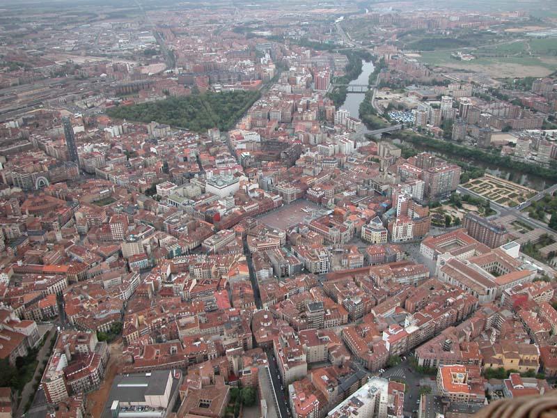
Valladolid desde el aire
Valladolid desde el aire User:Queninosta · CC BY-SA 3.0 · Commons
Madrid
Capital
Valladolid
Capital

Rulers

Government, Society and Religion

Almost immediately after the union of the two kingdoms under Ferdinand III, the parliaments of Castile and León were united. It was divided into three estates, which corresponded with the nobility, the church and the cities, and included representation from Castile, León, Galicia, Toledo, and the Basque Provinces. Initially the number of cities represented in the Cortes varied over the next century, until John I permanently set those that would be allowed to send representatives (procuradores): Burgos, Toledo, León, Sevilla, Córdoba, Murcia, Jaén, Zamora, Segovia, Ávila, Salamanca, Cuenca, Toro, Valladolid, Soria, Madrid, and Guadalajara (with Granada added after its conquest in 1492).

Read more

Under Alfonso X, most sessions of the Cortes of both kingdoms were held jointly.

From Wikipedia: Crown of Castile · History: Union of the Cortes and the legal code (CC BY-SA 4.0)

Government
Feudal monarchy subject to fueros
Languages
Basque, Galician, Astur-Leonese, Mozarabic, Andalusian Arabic, Judaeo-Spanish, Guanche
Religion
Official religion: Roman Catholicism, Minority religions: Islam, Sephardic Judaism

Coins, Currency and Symbols

Anverso Moneda 8 Maravedís de Felipe III (1607) Acuñada en Segovia
Anverso Moneda 8 Maravedís de Felipe III (1607) Acuñada en Segovia Cebeira · Public domain · Commons
Currency
Spanish maravedí, Spanish real

Wars and Battles

Henry IV unsuccessfully tried to re-establish the peace with the nobility that his father, John II, had shattered. When his second wife, Joan of Portugal, gave birth to Infanta Joanna, it was claimed that she was the result of an affair of the Queen with Beltrán de la Cueva, one of the King's chief ministers.

Read more

The King, besieged by riots and the demands of the nobles, had to sign a treaty in which he named as his successor his half-brother Alfonso, leaving Infanta Joanna out of the line of succession. After the death of Alfonso in an accident, Henry IV signed the Treaty of the Bulls of Guisando with his half-sister Isabella I in which he named her heiress in return for her marrying a prince chosen by him.

From Wikipedia: Crown of Castile · History: Second Conflict of Succession (CC BY-SA 4.0)

Achievements and Monuments

  • Torre Dorada
    Torre DoradaPrint made by: Nicolas Guérard I After: Felipe Pallota Published by: Nicolas de Fer · Public domain · Commons

Decline and Fall

Ended
1515 CE
Last recorded ruler
Charles V
Succeeded by
Kingdom of Spain

Michoacán

1305 CE – 1533 CE · Capital: Morelia · 74,593 km²

Iglesia de Cristo Rey en Yurécuaro, Michoacán
Iglesia de Cristo Rey en Yurécuaro, Michoacán Henryficar · CC BY-SA 4.0 · Commons

Michoacán, formally Michoacán de Ocampo, officially the Free and Sovereign State of Michoacán de Ocampo, is one of the 31 states which, together with Mexico City, compose the Federal Entities of Mexico. The state is divided into 113 municipalities and its capital city is Morelia (formerly called Valladolid). The city was named after José María Morelos, a native of the city and one of the main heroes of the Mexican War of Independence. Michoacán is located in western Mexico, and has a stretch of coastline on the Pacific Ocean to the southwest.

From Wikipedia: Michoacán (CC BY-SA 4.0)

Origins and Founding

The population sizes of the various language speakers in the Pátzcuaro basin differed significantly by c. 1200 AD, and among them the Nahuatl-speaking Chichimecs, that is the Uacúsecha of Pátzcuaro city, were small in number. Competition between the elites of these Chichimecs for access to basic resources led to several wars which resulted in the concentration of political and economic power among the Uacúsecha, with the warrior-leader Tariácuri uniting the various polities of the Pátzcuaro basin into a single state over the course of c. 1300 to c. 1350 AD.

Read more

After Tiariacuri's death, his son and his nephews continued to expand the state he founded outside of the Pátzcuaro basin, and initiated the political and economic changes which saw the foundation of the Purépecha Empire.

From Wikipedia: Michoacán · History: Formation of the Purépecha Empire (CC BY-SA 4.0)

Founded
1305 CE

Government, Society and Religion

Michoacán is the seventh most populated state in Mexico and the average resident has a life expectancy of 73.3 years. It is estimated that each year about 40,000 people immigrate to the state while 78,000 leave, leading to population loss. Of those who leave, about one third go to other places in Mexico and the rest to other countries, principally the United States. The cities with the densest populations are Morelia, Uruapan and Zamora. The majority of the population are mestizos; meaning that they are part indigenous, part European (mainly from Spain), and some African. Michoacán is one of the most Catholic regions in Mexico.

Read more

Charreada is an important sport in the state. It celebrates the mestizo culture and heritage of Michoacán; in which the Spaniards employed the indigenous people as vaqueros or ranchers to herd cattle.

From Wikipedia: Michoacán · Demographics (CC BY-SA 4.0)

Economy and Trade

Agriculture occupies over a million hectares of land in the state or 20% of the land area. Three-fifths of this agriculture occurs only during the rainy season. Irrigation farming is restricted to areas such as the Apatzingán Valley, the Bajío area of Michoacán, the Zamora Valley and some others. Principal crops include corn, sorghum, avocados, strawberries, peaches, wheat, limes, sugar cane and mangos. While corn accounts for 43% of the crops harvested, Michoacán is the largest producer of avocados in Mexico and in the world. 43% of farmland in the territory is dedicated to the raising of livestock, including cattle, domestic fowl, sheep, goats and pigs. In 2007, the state's production of meat, dairy and eggs was valued at over four billion pesos.

From Wikipedia: Michoacán · Economy: Agriculture (CC BY-SA 4.0)

Coins, Currency and Symbols

  • Escudo del Estado de Michoacán
    Escudo del Estado de Michoacán Gobierno de Michoacán · Public domain · Commons

Wars and Battles

President Felipe Calderón first sent troops into Michoacán to regain control of the territory and fight the current drug cartels that had power when he took office in 2006. But his efforts backfired and ended up creating more violence instead. The number of homicides increased substantially. The state of Michoacán has one of the highest murder rates in Mexico. In 2013, the criminal group, the Knights Templar Cartel, essentially controlled the state. Although they eventually lost control, excessive criminal violence persisted.

From Wikipedia: Michoacán · Crime: War on drugs (CC BY-SA 4.0)

Achievements and Monuments

The state provides public education from preschool level to high school. "Formal preschool" is offered in communities which have twenty five or more qualified students. Less formal preschools are operated in smaller communities. As of 1996, there were 5,433 primary schools serving 705,694 students with 25,485 teachers. There is a failure rate from grade to grade of about 9.7% with just under five percent leaving school permanently before finishing primary studies. The most common reason for departure is poverty. At the secondary level there are 174,354 students, which represent 22% of these eligible to attend. High school level studies are mostly geared to vocational studies and many attend via distance education. There are 24 public and private institutions of higher learning offering 49 different majors.

From Wikipedia: Michoacán · Education (CC BY-SA 4.0)

Tenochtitlan

1326 CE – 1428 CE · Capital: Tenochtitlan · 2,381 km²

Full view of Tenochtitlán
Full view of Tenochtitlán thomas kole · CC BY 4.0 · Commons

Tenochtitlan, also known as Mexico-Tenochtitlan, was a large Mexican altepetl in what is now the historic center of Mexico City. The exact date of the founding of the city is unclear, but the date 13 March 1325 was chosen in 1925 to celebrate the 600th anniversary of the city. The city was built on an island in what was then Lake Texcoco in the Valley of Mexico. The city was the capital of the expanding Aztec Empire in the 15th century until it was captured by the Tlaxcaltec and the Spanish in 1521. At its peak, it was the largest city in the pre-Columbian Americas.

From Wikipedia: Tenochtitlan (CC BY-SA 4.0)

Origins and Founding

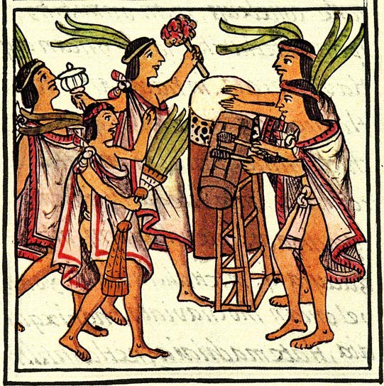
Aztec drums, Florentine Codex.
Aztec drums, Florentine Codex. Unknown author · Public domain · Commons
Founder
Mexica
Founded
1326 CE

Rulers

Government, Society and Religion

Tenochtitlan can be considered the most complex society in Mesoamerica in regard to social stratification. The complex system involved many social classes. The macehualtin were commoners who lived outside the island city of Tenochtitlan. The pipiltin were noblemen who were relatives of leaders and former leaders, and lived in the confines of the island. Cuauhipiltin, or eagle nobles, were commoners who impressed the nobles with their martial prowess, and were treated as nobles. Teteuctin were the highest class, rulers of various parts of the empire, including the king. Tlacohtin were slaves or indentured servants. Finally, the pochteca were merchants who traveled all of Mesoamerica trading. The membership of this class was based on heredity.

From Wikipedia: Tenochtitlan · Social classes (CC BY-SA 4.0)

Government
Monarchy
Languages
Classical Nahuatl
Religion
Aztec religion

Coins, Currency and Symbols

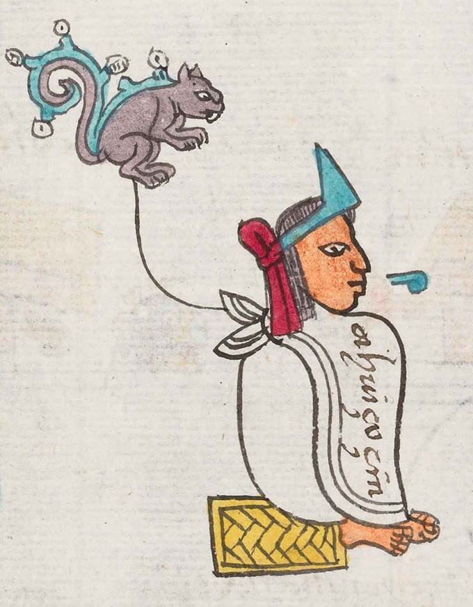
  • Tenochtitlan Glyph ZP
    Tenochtitlan Glyph ZP XcepticZP · Public domain · Commons

Wars and Battles

When Cortés and his men invaded Tenochtitlan, Moctezuma II chose to welcome Cortés as an ambassador rather than risk a war which might quickly be joined by aggrieved indigenous people.

Read more

As Cortés approached Tenochtitlan, the Tenochcah celebrated Toxcatl. At this event the most prominent warriors of each altepetl would dance in front of a huge statue of Huitzilopochtli. The Spanish leader, Pedro de Alvarado, who was left in charge, worried that the natives planned a surprise attack. He captured three natives and tortured them until they said that this was indeed planned to happen. During the festival, the Spaniards came heavily armed and closed off every exit from the courtyard so that no one would escape. This happened during their last days in Tenochtitlan.

Nobles lined each side of the city's main causeway, which extended about a league (4.83 km).

From Wikipedia: Tenochtitlan · History: Conquest (CC BY-SA 4.0)
Victories recorded
1

Decline and Fall

Ended
1428 CE
Last recorded ruler
Cuauhtémoc
Succeeded by
Mexico City

Medieval States of Mesoamerica and the Caribbean: Frequently Asked Questions

Which states existed in Mesoamerica and the Caribbean in this period?

This page maps 8 states of Mesoamerica and the Caribbean founded between 555 CE and 1326 CE: Classic Veracruz Culture, Later Mayan City-States, Toltec, Puebloans - Aztec Regional System, Texcoco, Crown of Castile, Michoacán, Tenochtitlan.

Which was the largest of the Medieval States of Mesoamerica and the Caribbean?

Crown of Castile had the largest mapped extent, about 535,551 km².

Which of the Medieval States of Mesoamerica and the Caribbean lasted longest?

Later Mayan City-States lasted longest, 850 CE – 1546 CE.

Sources

  • Reading text: Wikipedia articles on the group and each state, condensed (CC BY-SA 4.0).
  • Facts, rulers and wars: Wikidata (CC0).
  • Borders: Cliopatria, Seshat Global History Databank (CC BY 4.0).
  • Pictures: Wikimedia Commons; the author and licence are under each picture.

Largest state by mapped extent: Crown of Castile.