
UNESCO World Heritage Sites in Hungary
Hungary has 7 sites on the UNESCO World Heritage List (6 cultural and 1 natural), the first inscribed in 1987 (Budapest, including the Banks of the Danube, the Buda Castle Quarter and Andrássy Avenue). The map below plots every one of them alongside the rest of the List, and each site is written up in full further down the page.
- World Heritage Sites
- 7
- Cultural
- 6
- Natural and Mixed
- 1
- First Inscribed
- 1987
Map of World Heritage Sites in Hungary
CulturalNaturalMixedIn DangerLarge dots are in Hungary. Click a dot to read about the site.

Budapest, including the Banks of the Danube, the Buda Castle Quarter and Andrássy Avenue
Hungary · 47.4824° N, 19.0707° E · 5 km² · 2 km from Budapest
This site has the remains of monuments such as the Roman city of Aquincum and the Gothic castle of Buda, which have had a considerable influence on the architecture of various periods. It is one of the world's outstanding urban landscapes and illustrates the great periods in the history of the Hungarian capital.
Description from the UNESCO World Heritage Centre (CC BY-SA IGO 3.0).
Why Budapest, including the Banks of the Danube, the Buda Castle Quarter and Andrássy Avenue Is Listed
- (ii)
- An important interchange of human values.
- (iv)
- An outstanding example of a type of building or landscape.

Hollókő
Hungary · 47.9961° N, 19.5917° E · 1 km² · 21 km from Salgótarján
Hollókő (Hungarian: [ˈholloːkøː]) is a village in northern Hungary, located in Nógrád County. The village, which was constructed in the 13th century and developed in the 18th and 19th centuries, is a well-preserved ethnographic village of the Palóc people, with traditional wooden architecture and layout of buildings, farms, and orchards. Because of its exceptional preservation and testimony to rural life before the arrival of modern farming practices, the village was inscribed as a UNESCO World Heritage Site in 1987. Its name means "Raven-stone" in Hungarian.
Adapted from Wikipedia: Hollókő (CC BY-SA 4.0).
Why Hollókő Is Listed
- (v)
- An outstanding example of traditional human settlement or land use.
More about Hollókő
UNESCO's Description
Hollokö is an outstanding example of a deliberately preserved traditional settlement. This village, which developed mainly during the 17th and 18th centuries, is a living example of rural life before the agricultural revolution of the 20th century.
From the UNESCO World Heritage Centre (CC BY-SA IGO 3.0).
History
In the middle of the 13th century, in the aftermath of the Mongol invasion, construction of Hollókő castle first began as a means to protect the area against future attacks. At this time, the area around Hollókő was held by the Kacsics noble clan. The castle was first mentioned in records in 1310. The original village (now in ruins) was built just below the castle walls. The Ottomans captured the castle in 1552, and for the next 150 years, control alternated between Ottoman and Hungarian forces. At the end of the Ottoman era (1683), the castle and the village were finally abandoned, and the present town grew up in their place. Many of the existing houses were first built around this time.
Location
The village is located in Nógrád county, approximately 91.1 kilometres northeast of Budapest, the capital of Hungary. It lies in a valley of Cserhát Mountains, surrounded by low peaks. The natural environment is protected.
Sections adapted from Wikipedia: Hollókő (CC BY-SA 4.0).

Caves of Aggtelek Karst and Slovak Karst
Hungary, Slovakia · 48.4718° N, 20.4953° E · 567 km² · 46 km from Miskolc
The Caves of Aggtelek Karst and Slovak Karst are a series of over 1000 karst caves spread out over a total area of 55,800 ha (138,000 acres) along the border of Hungary and Slovakia. With an exceptional diversity of karst structures and complex cave systems developing from both temperate and tropical processes, the caves and surrounding areas were inscribed as a UNESCO World Heritage Site in 1995.
Adapted from Wikipedia: Caves of Aggtelek Karst and Slovak Karst (CC BY-SA 4.0).
Why Caves of Aggtelek Karst and Slovak Karst Is Listed
- (viii)
- An outstanding example of major stages of the Earth's history.
More about Caves of Aggtelek Karst and Slovak Karst
UNESCO's Description
The variety of formations and the fact that they are concentrated in a restricted area means that the 712 caves currently identified make up a typical temperate-zone karstic system. Because they display an extremely rare combination of tropical and glacial climatic effects, they make it possible to study geological history over tens of millions of years.
From the UNESCO World Heritage Centre (CC BY-SA IGO 3.0).
Background
This UNESCO World Heritage Site includes seven components, three of which are in Hungary, and four in Slovakia. In Hungary, the components include Aggtelek, Szendrő-Rudabánya Hill, and Esztramoill. The components in Slovakia are Dobšiná Ice Cave, Koniar plateau, Plešivec plateau, and a component neighbouring Silica and Jasov.
Baradla-Domica Cave complex is 21 km (13 mi) long with approximately one fourth of that on the Slovak side and the rest in Hungary. The first written mention of Baradla cave dates back to 1549 and from 1920 it serves as a tourist attraction. Ján Majko discovered Domica Cave (Slovak part of the complex) in 1926 and the tourist circuit opened to public in 1932 has more than 1,700 metres (5,600 ft).
Sections adapted from Wikipedia: Caves of Aggtelek Karst and Slovak Karst (CC BY-SA 4.0).
Key Facts
| Area | 567 km² |
|---|
Facts from Wikidata Q608090 (CC0).

Pannonhalma Archabbey
Hungary · 47.5528° N, 17.7611° E · 19 km from Győr
The Benedictine Pannonhalma Archabbey or Territorial Abbey of Saint Martin on Mount Pannonhalma (lat. Archiabbatia or Abbatia Territorialis Sancti Martini in Monte Pannoniae) is a medieval building in Pannonhalma and one of the oldest historical monuments in Hungary. Founded in 996, it is located near the town, on top of a hill (282 m). Saint Martin of Tours is believed to have been born at the foot of this hill, hence its former name, Mount of Saint Martin (Hungarian: Márton-hegy), from which the monastery occasionally took the alternative name of Márton-hegyi Apátság. It is the second largest territorial abbey in the world, after the one in Monte Cassino.
Its sights include the Basilica with the Crypt (built in the 13th century), the Cloisters, the monumental Library with 400,000 volumes, the Baroque Refectory (with several examples of trompe-l'œil) and the Archabbey Collection (the second biggest in the country). Because of the exceptional architectural evolution of the abbey over its 1000-year history and its historical importance as an international cultural and religious center, the abbey and its surroundings were inscribed on the UNESCO World Heritage List in 1996.
Adapted from Wikipedia: Pannonhalma Archabbey (CC BY-SA 4.0).
Why Pannonhalma Archabbey Is Listed
- (iv)
- An outstanding example of a type of building or landscape.
- (vi)
- A direct association with events, ideas or beliefs of universal significance.
More about Pannonhalma Archabbey
UNESCO's Description
The first Benedictine monks settled here in 996. They went on to convert the Hungarians, to found the country's first school and, in 1055, to write the first document in Hungarian. From the time of its founding, this monastic community has promoted culture throughout central Europe. Its 1,000-year history can be seen in the succession of architectural styles of the monastic buildings (the oldest dating from 1224), which still today house a school and the monastic community.
From the UNESCO World Heritage Centre (CC BY-SA IGO 3.0).
History
It was founded as the first Hungarian Benedictine monastery in 996 by Prince Géza, who designated this as a place for the monks to settle, and then it soon became the centre of the Benedictine order. The monastery was built in honour of Saint Martin of Tours. Géza's son, King Stephen I donated estates and privileges to the monastery. Astrik (Anastasius) served as its first abbot.
The oldest surviving document to use the Hungarian language, the Charter of the Tihany Benedictine Abbey, dating back to 1055, is still preserved in the library. In 1096, on his way to the holy lands as leader of one of three crusader armies, Duke Godfrey of Bouillon spent a week here negotiating his army's safe passage through Hungary from King Coloman.
Sections adapted from Wikipedia: Pannonhalma Archabbey (CC BY-SA 4.0).
Key Facts
| Established | 10th century |
|---|---|
| Area | 356 km² |
| Architectural style | Gothic architecture, baroque architecture |
Facts from Wikidata Q936285 (CC0).
Hortobágy National Park
Hungary · 47.5946° N, 21.1568° E · 748 km² · 36 km from Debrecen
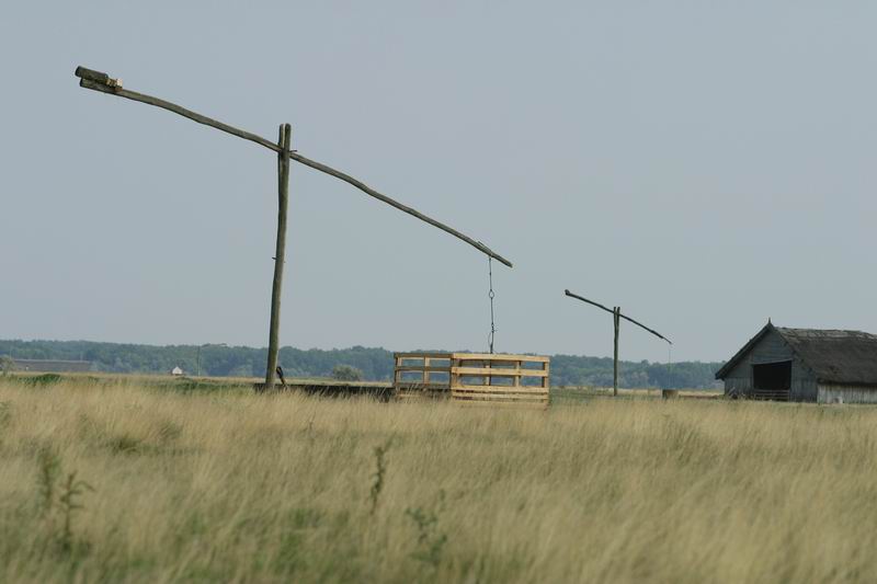
Hortobágy (Hungarian pronunciation: [ˈhortobaːɟ]) is an 800 km2 national park in eastern Hungary. The park, a part of the Alföld (Great Plain), was designated as a national park in 1973 (the first in Hungary), and elected among the World Heritage Sites in 1999. The Hortobágy is Hungary's largest protected area, and the largest semi-natural grassland in Europe.
Until recently it was believed that this alkaline steppe was formed by the clear cutting of huge forests in the Middle Ages, followed by measures to control the course of the Tisza River, allegedly resulting in the soil's current structure and pH. However, Hortobágy is much older, with alkalinization estimated to have started ten thousand years ago, when the Tisza first found its way through the Great Hungarian Plain, cutting off many streams from their sources in the Northern Mountains. The formation was finished by grazing animals and wild horses during the Ice Age, followed by domesticated animals. The site was inscribed on the UNESCO World Heritage List in 1999 because of its long cultural history (stretching back more than four millennia), its scenery, and its testimony to traditional methods of pastoralism.
Adapted from Wikipedia: Hortobágy National Park (CC BY-SA 4.0).
Why Hortobágy National Park Is Listed
- (iv)
- An outstanding example of a type of building or landscape.
- (v)
- An outstanding example of traditional human settlement or land use.
More about Hortobágy National Park
UNESCO's Description
The cultural landscape of the Hortobágy Puszta consists of a vast area of plains and wetlands in eastern Hungary. Traditional forms of land use, such as the grazing of domestic animals, have been present in this pastoral society for more than two millennia.
From the UNESCO World Heritage Centre (CC BY-SA IGO 3.0).
Key Facts
| Established | 1973 |
|---|---|
| Area | 801 km² |
Facts from Wikidata Q61757 (CC0).
Visiting Hortobágy National Park
National Park Hortobágy - The Puszta (Hungarian: Hortobágyi Nemzeti Park) is a first and biggest national park in Hungary. The park in Hajdú-Bihar County is a part of the Northern Great Plain (Alföld), and is listed on the UNESCO World Heritage site.
Travel notes adapted from Wikivoyage: Hortobágy (CC BY-SA 4.0).

Early Christian Necropolis of Pécs
Hungary · 46.0744° N, 18.2278° E · 1 km from Pécs
The Early Christian Necropolis of Pécs is a Roman cemetery and archeological site in Pécs, Hungary. Dating from the 4th century AD, the necropolis contains many decorated tombs, mausoleums, and burial chapels from the Early Christian period. It is one of the most significant Roman cemeteries outside of Italy. Because of its size, unique architecture, artistry, and testimony to the spread of Christianity in the Late Roman Empire, the necropolis was added to the UNESCO World Heritage List in 2000.
Adapted from Wikipedia: Early Christian Necropolis of Pécs (CC BY-SA 4.0).
Why Early Christian Necropolis of Pécs Is Listed
- (iii)
- A unique testimony to a cultural tradition or civilisation.
- (iv)
- An outstanding example of a type of building or landscape.
More about Early Christian Necropolis of Pécs
UNESCO's Description
In the 4th century, a remarkable series of decorated tombs were constructed in the cemetery of the Roman provincial town of Sopianae (modern Pécs). These are important both structurally and architecturally, since they were built as underground burial chambers with memorial chapels above the ground. The tombs are important also in artistic terms, since they are richly decorated with murals of outstanding quality depicting Christian themes.
From the UNESCO World Heritage Centre (CC BY-SA IGO 3.0).
History
In the 1st century AD, what would become western Hungary was incorporated into the Roman Empire as part of the province of Pannonia. Soon thereafter, the town of Sopianae was founded where modern-day Pécs stands, by colonists from the west who had intermarried with the local Illyrian-Celtic people. By the 4th century, the town had become prosperous because of its location at the crossroads of multiple trading routes. A cemetery was built to the north of the town, where it was used for Christian burials until the dissolution of the Roman Empire.
The first of the chambers was rediscovered and excavated in 1782, after the demolition of a Renaissance-era palace. Further excavations in the 20th century led by Otto Szőnyi and architect István Möller uncovered more tombs.
Description
In total, the necropolis contains 20 excavated monuments and over 500 more modest graves clustering around the major monuments. This represents one of the largest and densest collections of burial monuments in the northern and western Roman provinces. The monuments were for the wealthy families of Sopianae and served as both the burial site and the location of the burial ceremonies for these families. The necropolis has two stories: a network of underground chambers, catacombs, and crypts built out of limestone where the dead would be buried in sarcophagi or brick tombs, and above-ground chapels and mausoleums built on top.
Sections adapted from Wikipedia: Early Christian Necropolis of Pécs (CC BY-SA 4.0).
Key Facts
| Area | 0 km² |
|---|---|
| Architectural style | Early Christian architecture |
Facts from Wikidata Q927535 (CC0).
Tokaj Wine Region Historic Cultural Landscape
Hungary · 48.1500° N, 21.3500° E · 134 km² · 34 km from Nyíregyháza
The cultural landscape of Tokaj graphically demonstrates the long tradition of wine production in this region of low hills and river valleys. The intricate pattern of vineyards, farms, villages and small towns, with their historic networks of deep wine cellars, illustrates every facet of the production of the famous Tokaj wines, the quality and management of which have been strictly regulated for nearly three centuries.
Description from the UNESCO World Heritage Centre (CC BY-SA IGO 3.0).
Why Tokaj Wine Region Historic Cultural Landscape Is Listed
- (iii)
- A unique testimony to a cultural tradition or civilisation.
- (v)
- An outstanding example of traditional human settlement or land use.
World Heritage in Hungary: Quick Answers
- How many UNESCO World Heritage Sites are in Hungary?
- Hungary has 7 World Heritage Sites: 6 cultural and 1 natural.
- What was the first World Heritage Site in Hungary?
- Budapest, including the Banks of the Danube, the Buda Castle Quarter and Andrássy Avenue, inscribed in 1987. The most recent is Tokaj Wine Region Historic Cultural Landscape, inscribed in 2002.
- What are the natural World Heritage Sites in Hungary?
- Caves of Aggtelek Karst and Slovak Karst.
- Are any World Heritage Sites in Hungary in danger?
- None of the World Heritage Sites in Hungary is on UNESCO's List of World Heritage in Danger.